
Mori Atlas logo
Natural monumentThe Needles

Geographic analysis of vertical chalk strata, marine boundaries, and historic headland terrain

The Needles Natural Monument and Coastal Chalk Landscapes of the Western Isle of Wight

The Needles forms a striking row of vertical chalk sea stacks marking the western extremity of the Isle of Wight where the English Channel meets the Solent. This natural monument displays rare geological folding from the Alpine Orogeny, creating sharp profiles that descend into a protected Marine Conservation Zone. The surrounding landscape includes the high chalk downland of West High Down and the multi-coloured sands of Alum Bay, documenting both raw coastal geomorphology and historic land use.

chalk sea stacksIsle of WightEnglish Channelsea stackschalk geologycoastal lighthouse
A flat, vector-style illustration showing the Needles chalk stacks and a red and white striped lighthouse jutting out into the sea, with green coastal cliffs in the foreground and a setting sun in the background.

The Needles

Natural monument

Park overview

Structured park overview, official facts, and landscape profile for The Needles

The Needles park facts, protected area profile, and essential visitor context

Review the core facts for The Needles, including designation, size, terrain, visitor scale, habitats, and operating context in one park-focused overview.

About The Needles

The Needles occupy a singular place among British coastal landmarks, both for the geological drama of the chalk stacks themselves and for the layered history of the headland beside them. The formation rises from the western approaches to the Isle of Wight, where the chalk ridge that runs through the centre of the island slips into the sea at its most abrupt and exposed point. The result is a landscape defined as much by verticality and exposure as by colour, with bright chalk faces set against the open waters of the English Channel.

The site is approached from the cliffs above, where the Headon Warren and West High Down SSSI meets the coast. From these elevated downland viewpoints the stacks appear as a sharp, almost linear punctuation in an otherwise long, low horizon, with the lighthouse marking the seaward end of the group. The cliffs themselves support the characteristic chalk grassland and heath that give this stretch of the Isle of Wight much of its open, windswept character, and visitors typically encounter the headland on foot, by open-top bus, or by boat from Alum Bay below.

What distinguishes The Needles from many other chalk coastlines in southern England is the concentration of natural, military, and modern heritage in a compact setting. The Victorian artillery batteries, the mid-twentieth-century rocket engine testing facilities on High Down, the famous lighthouse, and the marine protected area all coexist here, each shaping how the place is read and experienced. For many visitors, the first impression is simply the stacks themselves; for those who spend time on the headland, the experience quickly expands into a wider story of geology, conservation, coastal defense, and the social history of the Isle of Wight.

Quick facts and research context for The Needles

The Needles sit off the western tip of the Isle of Wight in the English Channel, within the civil parish of Totland. Three chalk sea stacks rise roughly 30 metres above the water, with the Needles Lighthouse at the outer end of the row; the lighthouse, built in 1859, has been automated since 1994. The surrounding waters and seabed form part of the Needles Marine Conservation Zone, and the cliffs and chalk heath above lie within the Headon Warren and West High Down Site of Special Scientific Interest. The headland also contains decommissioned artillery batteries and the former High Down rocket testing site, both now in public or National Trust care.

Protection and recognition

Documented protection scope and international recognition details

The Needles Protection Status and Designated Conservation Framework

Comprehensive protected area records for The Needles outline documented conservation frameworks and mixed management classifications. Structured factual data provides clear insight into international recognition and official protection parameters.

Protection details

Protection scope
Mixed
Transboundary protection
No
Park context

Deeper park guide and search-rich context for The Needles

The Needles history, landscape, wildlife, and travel context

Explore The Needles through its history, landscape character, ecosystems, wildlife, conservation priorities, cultural context, and seasonal travel timing in a structured park guide built for atlas discovery and search intent.

Why The Needles stands out

The Needles is best known for its dramatic chalk sea stacks and its nineteenth-century lighthouse, together forming one of the most frequently photographed coastal landmarks in southern England. The near-vertical chalk strata that shape the stacks are a direct expression of the same geological folding that runs through the spine of the Isle of Wight and continues under the sea to features like Old Harry Rocks and Durdle Door on the Dorset coast. Equally distinctive is the layering of natural and human history at the site: chalk cliffs, marine habitat, Victorian coastal defenses, and mid-twentieth-century rocket testing all sit within a single small stretch of headland.
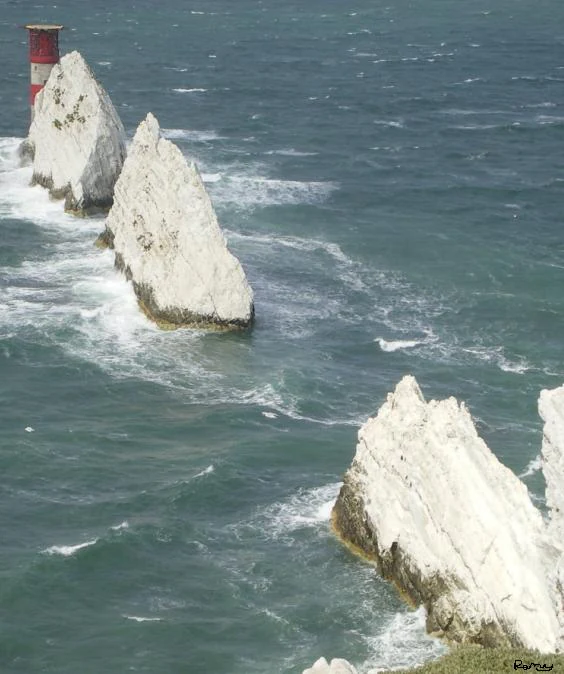
A high-angle view of the iconic Needles chalk stacks rising from the sea, with a red and white striped lighthouse situated on the outermost rock.
The Needles chalk stacks and lighthouse viewed from the Old Battery.

The Needles history and protected-area timeline

The Needles take their name from an event that occurred long after the formation itself was created. A fourth, needle-shaped stack known as Lot's Wife collapsed into the sea in 1764, and although the surviving rocks are blunt rather than pointed, the older descriptive name was already well established in the local dialect and on early maps. Place-name evidence suggests the area was referred to as early as the fourteenth century, with spellings such as 'Nedlen' in 1333 and 'les Nedeles' in 1409 showing the same root evolving across centuries.

In the 1860s the headland became a site of serious military investment, with coastal artillery batteries placed to defend the western approaches to the Solent. These batteries remained in use for nearly a century before being decommissioned in 1954. From 1956 to 1971 the same headland was repurposed for a very different kind of testing: rocket engines for the British ICBM programme were developed and fired at the High Down site, including the Black Knight and Black Arrow vehicles that later launched the Prospero X-3 satellite. The site was opened to visitors in 1982 when Prince Charles officially inaugurated the restored Needles Old Battery, and parts of the underground testing rooms have since been progressively brought back into public view.

In more recent history the location has continued to draw attention for both its nature and its climate exposure. During Storm Eunice on 18 February 2022, the highest recorded wind gust in England was provisionally measured at The Needles, reaching 122 miles per hour. The BBC featured the formation in its 2005 series Seven Natural Wonders as one of the wonders of Southern England.

The Needles landscape and geographic character

The Needles are unusual among British chalk coastlines because their strata have been folded until they stand nearly vertical, an effect of the Alpine Orogeny that compressed the region millions of years ago. Where chalk elsewhere in southern England forms rolling, smoothly sloping downs, here it forms sharp, blade-like profiles rising directly from the sea. The same chalk spine runs through the centre of the Isle of Wight from Culver Cliff in the east to the western tip, then continues beneath the English Channel to re-emerge on the Dorset coast at Ballard Cliff, Lulworth Cove, Durdle Door, and Old Harry Rocks, where the rotation of the strata from horizontal to vertical can be seen from the sea.

Above the stacks, the landscape is defined by the open chalk downland of West High Down and Headon Warren. These clifftop grasslands form a broad, exposed plateau descending steeply to the channel, with the stacks effectively marking the coastline's final, broken edge. To one side lies Alum Bay, famous for its multicoloured sands and a long-established tourist stop, and the quieter cove of Scratchell's Bay sits directly between the headland and the stacks. Just offshore, the Shingles, a shifting pebble shoal roughly three miles long, extends from the outer end of the formation and has historically been responsible for numerous shipwrecks, including HMS Assurance in the eighteenth century, HMS Pomone in the nineteenth, and the SS Varvassi in 1947.
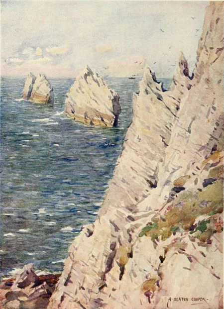
A historical watercolor painting showing the jagged white chalk sea stacks known as The Needles rising from the blue ocean.
A vintage painting of The Needles chalk stacks off the Isle of Wight.

The Needles ecosystems, habitats, and plant life

The ecological significance of The Needles extends across two distinct but linked environments. The waters and seabed around the stacks form part of the Needles Marine Conservation Zone, recognising the importance of the subtidal and seabed habitats of this stretch of the western Solent and the approaches to the English Channel. Historic wrecks on and around the stacks and the Shingles have also added artificial structure to the seabed, increasing habitat diversity in an area already shaped by strong tidal flows and shifting pebble substrates.

Above the cliff edge, the chalk cliffs and heath belong to the Headon Warren and West High Down Site of Special Scientific Interest, a designation that reflects both the geological interest of the exposed strata and the ecological character of the chalk grassland and low heath that clothe the clifftops. This combination of exposed sea cliffs, calcareous grassland, and coastal heath supports insect communities and birdlife typical of southern English chalk coasts, while the openness of the downland gives the headland its characteristic combination of wild scenery and wide horizons. Together with the marine designation, this gives The Needles a protected footprint that runs from the seabed beneath the stacks to the highest part of the clifftop plateau.
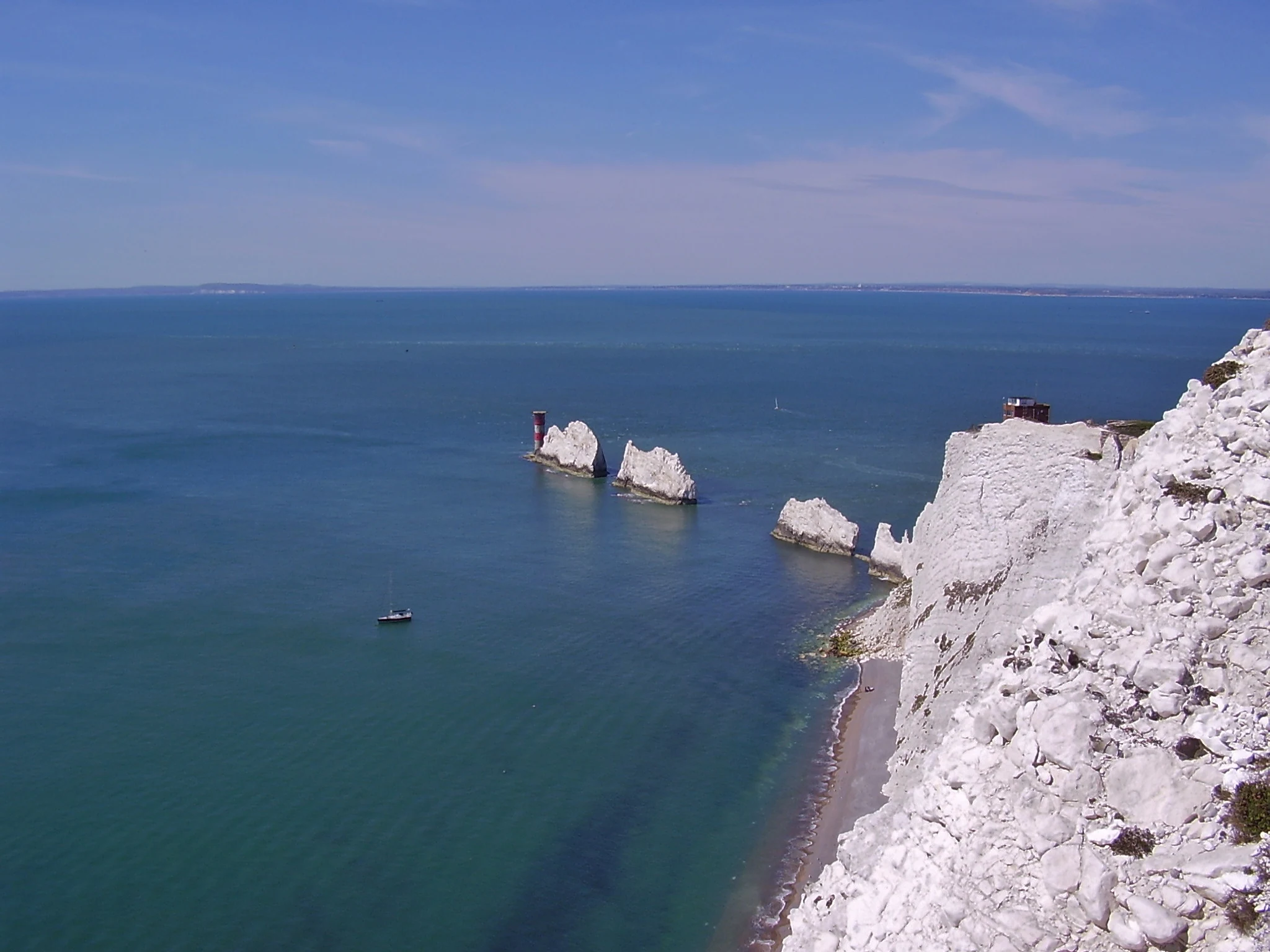
A wide angle view of the Needles chalk rock formations in the ocean, viewed from the top of the adjacent white cliffs, with a lighthouse visible on the furthest stack.
The iconic Needles chalk stacks extending into the sea from the white cliffs of the Isle of Wight.

The Needles conservation status and protection priorities

The Needles carries a strong layered conservation profile despite its small geographic footprint. Its marine conservation status comes from the Needles Marine Conservation Zone, which protects the seabed and waters of the western approaches to the Solent. Its terrestrial status comes from the Headon Warren and West High Down Site of Special Scientific Interest, which covers the chalk cliffs, grassland, and heath above the stacks. The combination is significant because it safeguards a continuous gradient from open marine habitat, through sea-cliff and coastal heath, up to the chalk downland on the clifftop.

The conservation value of the headland is closely tied to the geological conditions that shaped it. The near-vertical chalk, the exposure to salt-laden winds, and the thin, lime-rich soils all support plant communities adapted to harsh, base-rich conditions, while the adjoining marine environment is shaped by strong tidal exchange. Recognising both these systems together gives The Needles a measure of protection unusual for so compact a stretch of coast, ensuring that the geological features, the habitats, and the views themselves remain part of the protected natural heritage of southern England.

The Needles cultural meaning and human context

The Needles has been a cultural touchstone for the Isle of Wight for centuries, long before it became a packaged tourist attraction. The very name preserves a medieval dialect form, and early visitors, soldiers, and scientists have all left their mark here. The Victorian artillery batteries of the 1860s, the rocket testing program of the 1950s and 1960s, and the long-running operations of the Needles Lighthouse together tell a story of the headland as both a defensive frontier and a place of technological experimentation, set against the long backdrop of maritime traffic through the Solent.

In the modern imagination, the stacks have become shorthand for the Isle of Wight itself, appearing on postcards, souvenirs, and travel imagery across the island. The combination of a small amusement park at the top of the cliff, a chairlift down to the beach at Alum Bay, open-top 'Breezer' buses along the cliff road, and boat trips offering close-up views of the stacks has given the site a strongly visitor-facing identity. At the same time, ownership of key elements by the National Trust, the presence of a National Coastwatch Institution lookout, and the public opening of the restored Old Battery have kept the more serious historical layers easily accessible to anyone walking the headland.

Top sights and standout views in The Needles

A row of three chalk sea stacks rising about 30 metres out of the English Channel at the western tip of the Isle of Wight, with the automated Needles Lighthouse, built in 1859, at the seaward end of the group. The formation is framed by the multicoloured sands of Alum Bay, the quieter cove of Scratchell's Bay, and the open chalk downland of West High Down and Headon Warren. The seabed and waters are protected as the Needles Marine Conservation Zone, and the cliffs and heath above sit within the Headon Warren and West High Down SSSI. The same headland also contains Victorian artillery batteries and the former High Down rocket testing site used for Black Knight and Black Arrow engines.

Best time to visit The Needles

Spring and summer open up the most relaxed ways to experience The Needles, with open-top bus services running along the cliff road, the chairlift and amusement park at the top of the Alum Bay cliffs in operation, and regular boat trips leaving Alum Bay for close-up views of the stacks and lighthouse. In calmer summer weather the chalk colours read brighter against the sea and the headland's downland flowers are at their most visible.

Outside the high season, autumn and winter visits offer a wilder, emptier atmosphere, with generally fewer boats and quieter bus services, though the exposed clifftop walk to the batteries can be bracing and is officially closed to visitors in winds above force 8 on the Beaufort scale. The site is, by its nature, a place of strong weather, and the cliffs and the lighthouse take on a different kind of drama in stormy conditions; during Storm Eunice in February 2022 the location provisionally recorded the highest wind gust ever measured in England.

Monthly climate preview

Long-term representative climate data for The Needles across the twelve-month cycle

The Needles Climate Normals: Measured Monthly Temperature and Precipitation Rhythms

Representative coordinate records show measured monthly temperature variations and precipitation totals spanning twelve distinct observation periods at The Needles. Examining the complete monthly climate normals reveals deeper long-term trends in average thermal ranges and precipitation patterns.
Annual mean12 °C
7 °C17 °C
Jan
Feb
Mar
Apr
May12°
Jun14°
Jul17°
Aug17°
Sep16°
Oct14°
Nov11°
Dec
Warmest month
August

17.2 °C

Coolest month
February

7.1 °C

Wettest month
November

3.4 mm/day

Driest month
July

1.6 mm/day

Park location guide

Geography guide, regional context, and park location map for The Needles

The Needles park geography, regions, and map view in United Kingdom

Understand where The Needles sits in United Kingdom through a broader geographic reading of the surrounding landscape, nearby location context, and its mapped position within the national park landscape.

How The Needles fits into United Kingdom

The United Kingdom is a parliamentary constitutional monarchy located in northwestern Europe, consisting of four constituent countries: England, Scotland, Wales, and Northern Ireland. As a major global power with over 69 million residents, it maintains significant international influence in politics, economics, and culture.

Wider geography shaping The Needles in United Kingdom

The United Kingdom is an island nation located in northwestern Europe, surrounded by the Atlantic Ocean, North Sea, English Channel, Celtic Sea, and Irish Sea. It shares a land border with the Republic of Ireland to the west. The territory includes the island of Great Britain, the northeastern portion of Ireland, and most of the smaller British Isles islands.

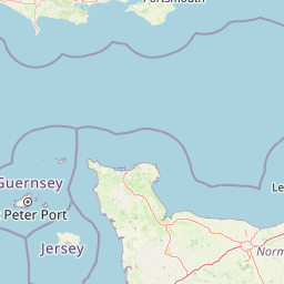
Map view of The Needles

Use this park location map to pinpoint The Needles in United Kingdom, understand its exact geographic position, and read its mapped placement within the surrounding landscape more clearly.

Pigeon | © OpenStreetMap contributors

Location context for The Needles

Isle of Wight

Explore detailed visual references of vertical chalk strata, cliff top downland, and protected coastal habitats.

The Needles Photos and Coastal Scenery: Visualising Chalk Sea Stacks and Marine Landscapes

Visual records capture the dramatic vertical chalk sea stacks and exposed clifftop downland that define the western extremity of the Isle of Wight. Detailed photography reveals the unique geological folding and marine conservation zone characteristics of this protected coastal landscape.

A high-angle view of the iconic Needles chalk stacks rising from the sea, with a red and white striped lighthouse situated on the outermost rock.

A close up aerial view of the Needles, three jagged chalk rock stacks emerging from dark sea water, with a red and white striped lighthouse standing on the edge of the nearest formation.

A historical watercolor painting showing the jagged white chalk sea stacks known as The Needles rising from the blue ocean.

A wide angle view of the Needles chalk rock formations in the ocean, viewed from the top of the adjacent white cliffs, with a lighthouse visible on the furthest stack.

Park atlas

Compare surrounding coastal landscapes and regional protected habitats

Other Parks and Protected Areas Near The Needles

Visitors exploring The Needles can continue browsing adjacent coastal reserves and protected chalk downlands in the surrounding region. Comparing nearby protected areas reveals broader geological formations and marine habitats connected to the English Channel coastline.
Watercolor painting showing a landscape with green and purple vegetation, a body of water, and distant hills.
National parkEngland
About 10 km away#1 closest

North

New Forest National Park: Historic Protected Landscape and Regional Geography in England

Mapped heathland, ancient woodlands, and pastoral traditions.

Explore New Forest National Park, a nationally significant protected area in England renowned for its unique blend of ancient royal forest history, traditional pastoral practices, and biologically rich lowland habitats. This page provides an atlas-focused view of its mapped boundaries, distinctive terrain, and geographic context within England, highlighting its value as a living landscape shaped by centuries of common grazing rights and supporting rare wildlife.

Area
566 km²
Established
2005
IUCN
V
Visitors
14.8M annual
Protected areaEngland
About 12 km away#2 closest

West

Dorset Heaths: Protected Lowland Landscapes and Regional Geography in Southern England

A comprehensive look at the Poole Basin heathland mosaic.

Spanning the Poole Basin, the Dorset Heaths offer a distinct geographic profile of acidic sands and diverse ecological mosaics. This protected area includes rare valley mires and coastal dunes, providing a clear window into the natural landscape history and ongoing conservation efforts within southern England's coastal regions.

Area
616.62 km²
Established
1998
Relief
Lowland
Water
Major water bodies
Watercolor painting of a coastline with rolling green cliffs meeting the sea, with small pink flowers in the foreground.
Protected landscapeUnited Kingdom
About 24 km away#3 closest

West

Jurassic Coast Protected Landscape: Geological Mapping and Coastal Atlas

A comprehensive look at sedimentary formations in the United Kingdom

Trace the 96-mile stretch of the Jurassic Coast, a protected landscape revealing Triassic, Jurassic, and Cretaceous rock layers. The terrain serves as a vital record of Earth history, featuring distinctive geomorphological landmarks like Chesil Beach and the towering cliffs of Golden Cap, all defined by the dynamic interaction of land and sea.

Established
2001
Relief
Upland
Climate
Temperate
Access
Easy access
A watercolor painting of a wide, soft-focus coastal scene with rolling green hills, distant islands, and calm water, depicted in muted pastel tones.
Protected areaDorset
About 24 km away#4 closest

West

Poole Harbour: Protected Area Geography and Coastal Map of Dorset

Coastal ria landscape and wetland habitat mapping

Poole Harbour stands as a prominent natural feature of the Dorset coast, defined by its shallow waters and varied estuarine terrain. This profile maps the protected landscape, including its salt marshes, seagrass meadows, and islands, offering deep geographic context for this significant southern England wetland.

Area
36 km²
Relief
Lowland
Climate
Temperate
Access
Easy access
Watercolor illustration of a coastal landscape featuring green hills, white cliffs, and a body of water
National parkSouth East England
About 39 km away#5 closest

East

South Downs National Park: A Distinctive Chalk Landscape in South East England's Atlas

Iconic chalk downland, coastal cliffs, and mapped terrain.

South Downs National Park is a premier protected landscape in South East England, celebrated for its unique chalk downland terrain and dramatic coastal formations. This page provides detailed geographic context for the park, highlighting its rolling hills, dry valleys, and ancient woodlands. Discover the park's mapped boundaries and its significance within England's protected areas, offering a structured atlas view for landscape exploration.

Area
1,627 km²
Established
2010
IUCN
V
Visitors
18M annual
Marine protected areaWest Sussex
About 80 km away#6 closest

East

Kingmere Marine Conservation Zone: Protected Marine Geography and Chalk Reef Landscapes

Submerged chalk cliff systems and rocky reefs in West Sussex

The Kingmere Marine Conservation Zone protects an unusual underwater landscape of chalk ridges and rocky outcrops within the English Channel. Stretching between Littlehampton and Worthing, this area serves as a vital spawning ground and exhibits some of the finest chalk reef features in European waters.

Area
47 km²
Established
2013
Relief
Lowland
Climate
Temperate
Watercolor painting of a wetland landscape featuring a winding river, rolling green hills, and soft-focus trees under a light sky.
Protected landscapeSomerset
About 91 km away#7 closest

Northwest

Somerset Levels Protected Landscape: Geographic Mapping and Wetland Terrain Analysis

A low-lying coastal plain and historic wetland basin in Somerset

Examine the distinct topography of the Somerset Levels, where flat horizons, pollarded willows, and ancient drainage channels create a unique English landscape. This protected area offers deep insight into prehistoric archaeology, including preserved Neolithic trackways, alongside modern wetland conservation of international significance within a rural basin.

Area
650 km²
Established
1997
Relief
Lowland
Climate
Temperate
Biosphere reserveSussex
About 107 km away#8 closest

East

Brighton and Lewes Downs Biosphere Reserve: Geography and Protected Coastal Landscapes

Chalk downlands and marine ecosystems in Sussex

The Brighton and Lewes Downs Biosphere Reserve anchors a diverse range of protected habitats from the South Downs ridges to the English Channel seafloor. This mapped record details the terrestrial chalk grasslands, coastal cliffs, and rare offshore reef systems that characterize this notable biosphere reserve in Sussex. It serves as a comprehensive geographic reference for understanding the boundary between land-based conservation and marine habitat management.

Area
295.14 km²
Established
2014
Visitors
12M annual
Relief
Upland

Common questions about visiting, size, designation, and location context for The Needles

The Needles FAQs for park facts, access, geography, and protected area context

Find quick answers about The Needles, including protected-area facts, park geography, trail and visitor context, and how the park fits into its surrounding country and regional landscape.
MoriAtlas Explorer

Continue Your Protected Areas Search Across the Global Atlas

Deepen your exploration by continuing the structured search for national parks and protected areas worldwide. Utilize the comprehensive filtering capabilities to compare different conservation landscapes and refine your understanding of global park geography. Discover more about the distribution and characteristics of protected natural areas.

Global natural geography