Volcanoes
Montaña del Valle de la Tranquilidad
436 m

Analyzing the volcanic terrain, territorial extent, and regional geography in Spain
This geographic profile covers the spatial characteristics of Timanfaya National Park located in the Canary Islands. The dataset includes a structured assessment of its 51.07 square kilometer area, boundary-derived span, and the concentration of volcanic peaks and calderas within the protected territory. Detailed spatial data supports a technical understanding of this subtropical mountain landscape.
Volcanic wilderness where fire once reshaped an island
Timanfaya National Park is a dramatic volcanic landscape occupying the southwestern portion of Lanzarote in the Canary Islands, Spain. Established in 1974, it encompasses approximately 51 square kilometers of almost entirely volcanic terrain, making it the only national park in Spain that is exclusively geological in character. The park protects one of the most significant recent volcanic formations in the Macaronesian region, shaped primarily by the spectacular eruptive period between 1730 and 1736 that buried nine villages and transformed a quarter of the island. Today, Timanfaya stands as a powerful testament to volcanic forces, with surface temperatures still reaching extreme heat at shallow depths, creating natural steam geysers that remain an active demonstration of the geothermal energy still present beneath the landscape.
Protected Island Territory of Spain within the Canary Islands
Interactive boundary geometry and recorded spatial dimensions
Mapped Volcanic Formations and Protected Terrain Classifications
Volcanoes
436 m
Volcanoes
388 m
Volcanoes
Volcanoes
366 m
Volcanoes
226 m
Volcanoes
364 m
Subtropical mountain relief and volcanic landscape categories
Volcano
Compare unique volcanic landscapes and Atlantic island protected areas across the Canary archipelago
Southwest

A rugged volcanic and geological interior landscape
Investigate the topographical intensity of Parque rural de Betancuria, home to the Betancuria Massif and unique Basal Complex exposures. This protected landscape documents a long history of geological transformation and traditional human adaptation to the arid Fuerteventura environment.
Southeast
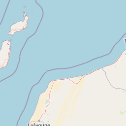
Explore the geographic context and landscape of this protected area.
Gulf of Khnifiss National Park is a designated national park offering vital insights into Western Sahara's protected landscapes. Its mapped boundaries and regional geography are crucial for understanding the park's ecological and cartographic significance within the atlas. Discover the essential characteristics that define this protected area's unique place in the natural terrain.
Southeast

Explore its mapped protected area and regional geography.
Khenifiss National Park offers a distinct entry into protected landscape exploration within the Laâyoune-Sakia El Hamra region. This park detail page provides core geographic context, focusing on its mapped boundaries and its significance as a protected natural area. Dive into the structured data that defines Khenifiss National Park, facilitating a deeper atlas-based understanding of its landscape and regional distribution.
Southwest
Exploring laurel forest strongholds and rugged ravine geography.
Parque rural de Doramas encompasses over 3,500 hectares of diverse northern Gran Canaria terrain, where steep-sided barrancos support rare laurisilva and monteverde vegetation. This protected landscape serves as a living remnant of the island's once-vast indigenous forests, offering a unique opportunity to study the relationship between human-influenced agricultural slopes and wild, humid forest refuges found deep within the island's northern flanks.
Southwest
Mapping the dramatic erosional landscapes and endemic ecosystems of central Gran Canaria.
Spanning the core of Gran Canaria, Parque rural del Nublo is a vast protected landscape characterized by its rugged volcanic topography. The area features the iconic Roque Nublo monolith, deeply incised barrancos, and a mosaic of pine forests and endemic scrubland. This territory represents a critical intersection of geological evolution and aboriginal history, containing major UNESCO-listed cultural sites within its complex highland boundaries.
West
A detailed geographic overview of the Anaga massif protected landscape.
Parque rural de Anaga preserves a dramatic landscape of volcanic plugs, deeply incised valleys, and endemic-rich cloud forests in the Canary Islands. Understand the complex terrain and protected area boundaries that define this historic massif, from its coastal cliffs to its high mountain ridges.
West
Explore protected volcanic terrain and mapped geography on Tenerife.
Teide National Park protects the highest point in Spain, Mount Teide, within a spectacular caldera and surrounding volcanic terrain on Tenerife. This national park offers a unique landscape for geographic discovery, showcasing dramatic lava flows, volcanic cones, and endemic flora. Its protected boundaries define a significant area of natural interest, making it a key landmark for atlas exploration of island geography and protected lands.
West
Coastal cliffs, volcanic barrancos, and laurel forest ecosystems.
Parque rural de Teno serves as a primary geographic anchor for northwest Tenerife, encompassing a triangular volcanic block defined by vertical sea cliffs and steep, eroded ravines. This protected landscape preserves unique biodiversity and traditional cultural architecture, offering a comprehensive look at the island's geological and ecological variety from the shoreline to the mist-prone summits.
Delve deeper into the unique atlas context of Timanfaya National Park, a protected area defined by its extraordinary volcanic terrain and ongoing geothermal activity. Understanding its mapped boundaries and landscape character provides essential geographic insight into the Canary Islands' natural heritage. Discover the specific geological narratives that make this national park a significant landmark for regional exploration and protected area study within the MoriAtlas platform.