
Sinkholes
Park geography
A detailed structural breakdown of the protected land area and natural landscapes
Reserva de la biosfera de Urdaibai Geographic Profile: Boundaries, Elevation and Terrain
The geographic scope of Reserva de la biosfera de Urdaibai encompasses 224.52 square kilometers of diverse terrain within the Basque Country of Spain. This profile details the vertical elevation range, coastal features, and environmental classifications that define the protected landscape from sea level to peaks reaching 804 meters.
An Atlantic estuary on the Basque coast, protected for its wetlands, woodlands, and migratory birds.
Urdaibai Biosphere Reserve
Urdaibai Biosphere Reserve is a protected coastal and estuarine landscape in the Busturialdea region of Biscay, in the Basque Country of northern Spain. Designated by UNESCO in 1984, it centers on the estuary of the Oka River, which flows through Gernika and empties into the Cantabrian Sea between the towns of Bermeo and Mundaka. The reserve combines a tidal estuary, broad sand flats, Atlantic cliffs and islands such as Izaro, and a ring of low green mountains including the slopes of Mount Oiz. The ecological heart of Urdaibai is its marshland, the largest and best preserved in the Basque Country and one of the most important wetland complexes on the Cantabrian and Atlantic coast of the Iberian Peninsula. Together with the Marismas de Santoña it forms a key refuge for migratory birds and an internationally recognized wintering site for waterfowl along the East Atlantic Flyway. Cantabrian oak forests of holm oak and strawberry tree, Atlantic oak woodlands, planted conifer forests, and karst limestone hills create a striking diversity of nearby habitats. Beyond its natural value, Urdaibai encompasses a deeply human landscape of pre-Roman and Roman heritage, fishing villages, surf-famous beaches, and the symbolic town of Gernika, home to the Tree of Gernika and the historic Basque parliament. The reserve balances conservation with active farming, forestry, fishing, and tourism, and is governed through a dedicated management plan and a Patronato that coordinates research, education, and sustainable development across the 22 municipalities that share its territory.
- Location
- Spain
- Park type
- Biosphere reserve
- Established
- 1984
- Area
- 224.5 km²
- Highest point
- 804 m
Location overview
Country memberships, administrative regions, and coastal geographic status
Geographic Overview and Location Profile for Reserva de la biosfera de Urdaibai
Reserva de la biosfera de Urdaibai anchors its protected territory within Spain and the Basque Country region. Administrative records verify coastal, island, and marine zone classifications for the protected area.
- Countries
- Spain
- Regions
- Basque Country
- Primary location
- Basque Country
- Geographic setting
- Coastal · Island · Marine
Boundary and coordinates
Interactive boundary geometry and derived spatial measurements
Reserva de la biosfera de Urdaibai Boundary Map and Geographic Extent
Mapped geographic outlines provide clear spatial context for the protected territory. Accompanying boundary facts detail total surface area, coordinate spans, and center points derived from spatial data.
- Boundary area
- 219.6 km²
- Boundary perimeter
- 97.1 km
- Northernmost point
- 43.4569° N
- Southernmost point
- 43.2237° N
- Easternmost point
- 2.5693° W
- Westernmost point
- 2.7721° W
- Geographic centre
- 43.3296° N, 2.6778° W
- North–south span
- 25.9 km
- East–west span
- 16.4 km
Elevation and terrain
Vertical range data and recorded natural features across the landscape
Reserva de la biosfera de Urdaibai terrain and elevation profile
Recorded elevation metrics span from zero meters at sea level up to eight hundred four meters across mixed terrain. Linked feature cards supply names, types, and spatial relationships for recorded peaks, forests, bays, and viewpoints.
- Minimum elevation
- 0 m
- Maximum elevation
- 804 m
- Highest point
- 804 m
Selected named natural features
Cave entrances
Mallokubarriko Koba I
Sinkholes
Matxibarreko zuloa
Sinkholes
Elesuko leizea III
Cave entrances
Santimamiñeko Koba
Cave entrances
Mestraituazarreko koba
Environmental setting
Temperate climate zones, mixed relief, and dominant water presence across protected landscapes
Environmental Setting and Habitat Classifications of Reserva de la biosfera de Urdaibai
Recorded landscape features and habitat types provide complementary ways to read the physical setting of Reserva de la biosfera de Urdaibai. Stored classifications connect recorded environmental categories to relevant atlas destinations where available.
- Relief
- Mixed relief
- Climate
- Temperate
- Water
- Water-dominated
- Forest cover
- Partial forest
- Seasonality
- Year-round
Landscape features
Mountains · Cliffs · Forest · Wetland · Lakes · Rivers · Coast · Beach · Dunes · Islands · Cave · Karst
Habitat types
Temperate broadleaf forest · Mediterranean forest · Wetland · Coastal habitat · Marine habitat · Dune habitat · Karst habitat
Park atlas
Compare adjacent coastal wetlands, river estuaries, and regional mountain terrain.
Other Protected Areas and Parks Near Reserva de la biosfera de Urdaibai
Browsing other protected areas near Reserva de la biosfera de Urdaibai reveals how coastal wetlands and limestone ranges connect across the regional landscape. Comparing these neighboring natural territories provides broader geographical context for northern Spain.
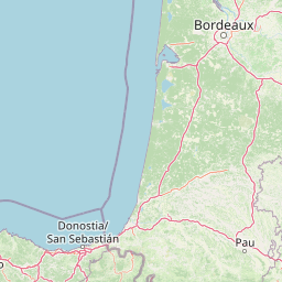
Nature reserveNouvelle-Aquitaine
About 86 km away#1 closest
East

Réserve naturelle régionale d'Errota Handia: Protected Wetland and Basque Geographic Atlas
Examining the ecological terrain of a historic French millpond reserve
Explore the structured geography of Réserve naturelle régionale d'Errota Handia, a compact but ecologically significant nature reserve in the Pyrénées-Atlantiques. This resource provides a detailed look at the park boundaries, wetland-woodland mosaic, and the historic hydraulic infrastructure that defines this unique Basque landscape, offering an essential perspective for understanding regional conservation in southwestern France.
- Area
- 0.095 km²
- Established
- 2001
- IUCN
- IV
Biosphere reserveLa Rioja
98 km away#2 closest
South

Valles del Jubera, Leza, Cidacos y Alhama: Protected Landscapes in La Rioja, Spain
A biosphere reserve featuring limestone gorges and dinosaur fossil sites
Valles del Jubera, Leza, Cidacos y Alhama forms a distinct mid-mountain region in northern Spain where four river valleys have carved deep passages into the earth. The area serves as a vital protected landscape containing rich paleontological history, thermal springs, and traditional Mediterranean forests. This atlas entry details the natural boundaries and geographic character of one of Spain's significant biosphere reserves.
- Area
- 1,196.69 km²
- Established
- 2003
Nature reserveNouvelle-Aquitaine
About 124 km away#3 closest
East
Réserve naturelle régionale du site des carrières de Tercis-les-Bains Protected Landscape
Geological stratotype and Cretaceous fossil reference site in Nouvelle-Aquitaine
This unique nature reserve in southwestern France protects a globally significant Cretaceous geological sequence within former limestone quarries. It serves as a vital scientific landmark for stratigraphy, housing extensive fossil records and structural evidence of salt-driven geology, all set within the scenic terrain of the Adour river basin.
- Area
- 0.448 km²
- Established
- 2015
- IUCN
- IV
- Relief
- Lowland
Protected landscapeCastilla y León
141 km away#4 closest
South
Sabinares del Arlanza-La Yecla: A Detailed Protected Landscape and Map of Burgos
Ancient juniper woodlands and deep limestone ravines in Castilla y León.
This protected area centers on the remarkable juniper forests and the narrow, vertical walls of the La Yecla gorge. The landscape serves as an essential habitat for cliff-nesting raptors while bridging the terrain between the Sierra de la Demanda foothills and the Arlanza River basin. The map captures the geological diversity of these limestone structures and the expansive botanical value found within this significant Spanish natural entity.
- Area
- 391.74 km²
- Established
- 2020
- IUCN
- V
- Relief
- Upland
Marine protected areaAsturias
143 km away#5 closest
Northwest
El Cachucho Marine Protected Area: Submarine Seamount and Cantabrian Sea Geography
Offshore protected landscapes and deep sea terrain mapping
El Cachucho represents a critical offshore protected area, defined by its massive seamount structure and proximity to the Asturian coastline. This marine habitat encompasses a complex array of geomorphological features, including rocky escarpments and submarine canyons that channel sediment across the narrow northern Iberian shelf, offering a detailed perspective on deep sea environmental architecture.
- Area
- 57 km²
- Relief
- Upland
- Climate
- Temperate
- Access
- Remote access
National parkSpain
151 km away#6 closest
West
Picos de Europa National Park: Dramatic Limestone Peaks and Protected Landscape Atlas
Explore Spain's historic national park and UNESCO Biosphere Reserve.
Picos de Europa National Park offers an unparalleled exploration of dramatic limestone peaks, deep glacial valleys, and extensive Atlantic forests. As Spain's oldest national park and a UNESCO Biosphere Reserve, it presents a remarkable study in karst landscape evolution and biodiversity conservation. This protected area, spanning significant territory across northern Spain, provides a rich geographic context for understanding regional natural heritage and mapped natural features.
- Area
- 671.27 km²
- Established
- 1918
- IUCN
- II
- Relief
- Mountain
National parkHautes-Pyrénées
160 km away#7 closest
East
Pyrénées National Park: Protected Landscape & Transboundary Protected Area Atlas
Discover Hautes-Pyrénées' dramatic glacial terrain and alpine environments.
Pyrénées National Park is a significant protected area in France's Hautes-Pyrénées department, renowned for its dramatic glacial cirques, high-altitude lakes, and extensive mountain landscapes. Established as a national park, it offers rich geographic context for atlas exploration, showcasing millions of years of geological formation shaped by tectonic uplift and glacial carving. This park is also notable for its transboundary conservation efforts with Spain, contributing to a broader protected region. Explore its unique terrain, from towering limestone formations to alpine meadows, and understand its place within the Pyrenean mountain range.
- Area
- 458 km²
- Established
- 1967
- IUCN
- II
- Relief
- Mountain
Nature reserveGironde
About 184 km away#8 closest
Northeast
Réservoirs de Piraillan Nature Reserve: Mapping the Coastal Ecology of the Cap Ferret Peninsula
A protected mosaic of saltwater basins and pine-forested islets in Gironde.
Explore the structured geography of Réservoirs de Piraillan, a forty-hectare classified natural reserve situated on the Cap Ferret peninsula in southwestern France. This site offers a rare contrast between historical fish reservoirs and dense maritime pine forest, providing a protected habitat for diverse bird and insect populations adjacent to the Bassin d'Arcachon. Understand the interplay between these saltwater pools and the wider coastal terrain of the Gironde department through detailed mapping and landscape data.
- Area
- 0.4 km²
- Established
- 1943
- Relief
- Lowland
- Climate
- Mediterranean
MoriAtlas Explorer
Continue Exploring the Geographic Boundaries of Reserva de la biosfera de Urdaibai
Analyze the protected ecosystems and mapped terrain of this Basque biosphere reserve through MoriAtlas. Examine how the Oka River estuary, limestone hills, and Atlantic coastal cliffs create a distinct protected zone of international importance for regional geography and conservation.
Browse next
Global natural geography
Explore related park routes
Explore MoriAtlas Global ParksBrowse All MoriAtlas ParksGlobal Park Map DiscoveryMoriAtlas: Browse All CountriesBrowse All MoriAtlas ContinentsNational Park Environment AtlasGrand Canyon National Park AtlasYellowstone National Park AtlasYosemite National Park Atlas and GeographySerengeti National Park AtlasGalápagos National Park Protected LandscapeBanff National Park Geography and AtlasKruger National Park Atlas EntryUluṟu-Kata Tjuṯa National Park AtlasExplore Uluru-Kata Tjuta National Park GeographyPlitvice Lakes National Park AtlasFiordland National Park Protected LandscapeGreat Smoky Mountains National Park AtlasAfghanistan National Parks and Protected AreasAlbania National Parks and Protected AreasAlgeria National Parks and Protected AreasAmerican Samoa National Parks and Protected AreasAndorra National Parks and Protected AreasAngola National Parks and Protected AreasAntarctica National Parks and Protected AreasAntigua and Barbuda Park List