

Mori Atlas logo
National parkWaka National Park

Detailed mapping and exploration of this national park's natural terrain.

Waka National Park: Gabon's Protected Landscape and Geographic Context

Waka National Park stands as a key protected area within Gabon, offering critical insight into the equatorial geography of Central Africa. As a designated national park, its boundaries define a significant natural landscape ripe for atlas-based discovery. This detailed entry provides context for understanding the park's geographic setting and its mapped presence within Gabon's diverse terrain.

rainforestsavannamountaincentral Africanational parkold-growth forest

Waka National Park

National park

Park overview

Structured park overview, official facts, and landscape profile for Waka National Park

Waka National Park park facts, protected area profile, and essential visitor context
Review the core facts for Waka National Park, including designation, size, terrain, visitor scale, habitats, and operating context in one park-focused overview.

About Waka National Park

Waka National Park represents an important component of Gabon's protected area network, established in 2002 to preserve the natural values of the Chaillu Massif region in central Gabon. The park encompasses approximately 1,060 square kilometers of terrain characterized by the interplay between dense tropical rainforest and more open savanna landscapes. This mosaic of habitats creates ecological diversity within a single protected area, supporting species adapted to both forest and grassland environments. The Chaillu Massif provides the geological foundation for the park, with landscape features that have developed over tens of thousands of years. The park's establishment reflects Gabon's commitment to conserving its biodiversity heritage, with management overseen by the National Agency for National Parks. Visitors and researchers to Waka encounter a landscape shaped by ancient geological processes and continuing ecological dynamics, where forest and savanna coexist in a pattern characteristic of central African highlands.

Quick facts and research context for Waka National Park

Waka National Park is located in central Gabon, within the Chaillu Massif region. The protected area spans roughly 1,060 square kilometers of terrain combining tropical rainforest and savanna habitats. Established in 2002, the park is managed by Gabon's National Agency for National Parks and holds IUCN category II designation. The landscape features ancient terrain dating back approximately 40,000 years, with the prominent Ikobe-Ikoi-Onoi rift representing a notable geological feature.

Park context

Deeper park guide and search-rich context for Waka National Park

Waka National Park history, landscape, wildlife, and travel context
Explore Waka National Park through its history, landscape character, ecosystems, wildlife, conservation priorities, cultural context, and seasonal travel timing in a structured park guide built for atlas discovery and search intent.

Why Waka National Park stands out

Waka National Park is notable for protecting a diverse mosaic of ecosystems where tropical rainforest meets savanna, a relatively rare combination in protected areas. The park's location within the Chaillu Massif provides it with mountainous terrain and older geological formations, distinguishing it from Gabon's coastal and lowland parks. The deeply incised Ikobe-Ikoi-Onoi rift adds geological significance to the park's character, while the ancient age of the landscape contributes to its ecological value as an old-growth environment.

Waka National Park history and protected-area timeline

Waka National Park was established in 2002 as part of Gabon's systematic expansion of its national park network during the early 2000s. The creation of the park reflected Gabon's broader conservation strategy to designate protected areas across diverse ecological zones, from coastal ecosystems to interior forest and mountain regions. The Chaillu Massif had long been recognized for its ecological and geographical significance, and the formal protection of the area under national park status provided institutional framework for long-term conservation. The park's establishment in the early 2000s came during a period when Gabon was developing its modern protected area management system through the National Agency for National Parks. This timing placed Waka within a cohort of newer protected areas in Gabon, designed according to contemporary conservation standards and international protected area categories.

Waka National Park landscape and geographic character

The landscape of Waka National Park is defined by its location within the Chaillu Massif, a mountainous region in central Gabon that rises above the surrounding lowland terrain. The park's terrain includes both the forested slopes and valleys of the massif as well as more open savanna areas that interrupt the continuous forest cover. A distinctive geological feature is the Ikobe-Ikoi-Onoi rift, a deeply incised valley system that breaks the general continuity of the landscape. This rift creates topographic variation and exposes older geological formations within the park. The combination of mountain terrain, forest, and savanna within a relatively compact area gives Waka a varied scenic character. The ancient geological age of the landscape, with formations dating back approximately 40,000 years, adds depth to the park's physical character beyond its immediate topography.

Waka National Park ecosystems, habitats, and plant life

Waka National Park protects a transitional ecological zone where tropical rainforest and savanna meet, creating a mosaic of habitats within the Chaillu Massif. The rainforest component represents Gabon's characteristic dense tropical forest, while the savanna portions provide open grassland environments with scattered trees. This habitat mosaic supports ecological communities adapted to both forest and savanna conditions, creating biodiversity value through the presence of species from different ecological backgrounds. The mountain setting of the park influences local climate and vegetation patterns, with elevation changes affecting temperature and moisture conditions across the terrain. The protected status of the area aims to maintain these ecological communities and the natural processes that sustain them.

Waka National Park conservation status and protection priorities

Waka National Park contributes to Gabon's conservation network by protecting a representative sample of the country's mountain and highland forest environments. The IUCN category II designation reflects the park's primary objective of preserving natural ecosystems while allowing for sustainable management. The combination of rainforest and savanna within a protected area provides ecological resilience and supports biodiversity conservation across multiple habitat types. The Chaillu Massif location adds geological conservation value, with the ancient landscape features representing natural heritage worth preserving. The park's management under the National Agency for National Parks connects it to Gabon's broader system of protected areas, contributing to national and regional conservation objectives.

Top sights and standout views in Waka National Park

Waka National Park offers visitors access to a distinctive mountain forest landscape in central Gabon, combining tropical rainforest with savanna ecosystems in the Chaillu Massif. The park protects terrain with geological features dating back approximately 40,000 years, providing a window into ancient landscape evolution. The Ikobe-Ikoi-Onoi rift represents a particularly dramatic geological feature within the park. As a relatively recent addition to Gabon's protected area network, established in 2002, Waka reflects contemporary conservation approaches to preserving central African biodiversity.

Best time to visit Waka National Park

Waka National Park can be visited throughout the year, with the dry season typically offering easier access to trail areas and clearer visibility for landscape observation. The wet season brings higher rainfall to the Chaillu Massif region, which affects trail conditions and may limit some access routes. Visitors planning trips to the park should consult current conditions and local guidance for the most suitable travel timing.
Park location guide

Geography guide, regional context, and park location map for Waka National Park

Waka National Park park geography, regions, and map view in Gabon
Understand where Waka National Park sits in Gabon through a broader geographic reading of the surrounding landscape, nearby location context, and its mapped position within the national park landscape.

How Waka National Park fits into Gabon

Gabon is a Central African country on the Atlantic coast, positioned on the equator. It gained independence from France in 1960 and is governed as a unitary presidential republic. The country has significant oil wealth and one of the highest Human Development Index rankings in Africa, though wealth distribution remains uneven.

Wider geography shaping Waka National Park in Gabon

Gabon is situated on the Atlantic coast of Central Africa, positioned along the equator. It borders Equatorial Guinea to the northwest, Cameroon to the north, and the Republic of the Congo to the east and south. The terrain includes coastal plains along the Atlantic, mountain ranges in the center (the Cristal Mountains and Chaillu Massif), and savanna zones in the east.

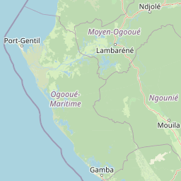
Map view of Waka National Park

Use this park location map to pinpoint Waka National Park in Gabon, understand its exact geographic position, and read its mapped placement within the surrounding landscape more clearly.

Pigeon | © OpenStreetMap contributors
Park atlas

Compare Waka National Park with other protected landscapes and mapped terrain across Gabon's central region.

Discover Related National Parks and Protected Areas Near Waka National Park, Central Gabon
After exploring Waka National Park, browse additional protected areas that share similar mountainous rainforest and savanna ecosystems in Gabon and the wider central African region. This geographic comparison offers insight into diverse conservation landscapes and regional park patterns beyond a single protected area.
Watercolor painting of a landscape with grassy areas, a lake, and distant hills under a light sky
National parkGabon

Lopé National Park: Gabon's Protected Landscape and National Park Geography

Explore mapped boundaries and natural terrain in Central Africa.

Delve into Lopé National Park, a designated national park situated in Gabon. This protected area serves as a crucial point for understanding the nation's geography and the distribution of its conservation landscapes. As an entry in the MoriAtlas, it offers a detailed view of its mapped territory and its contribution to the broader regional context of Central Africa, emphasizing its role in protected area atlas exploration.

Area
4,910 km²
Established
2002
IUCN
II
Relief
Mixed relief
National parkGabon

Birougou National Park: Mapped Protected Landscape and Regional Geography in Gabon

Explore the geographic extent and conservation context of this national park.

Birougou National Park is an important protected area situated in Gabon, offering a distinct focus for geographic and atlas-based discovery. This national park serves as a significant element within the country's network of conservation landscapes, providing a focal point for understanding mapped terrain and regional geographic patterns. Users can explore its protected boundaries and gain insight into its specific environmental context within Central Africa, making it a vital entry for atlas exploration of Gabon's natural heritage.

Area
690 km²
Established
2002
IUCN
II
Relief
Mountain
National parkGabon

Moukalaba-Doudou National Park: Gabon's Forest-Savanna Mosaic Protected Landscape

Atlas exploration of unique habitats and geographic boundaries.

Moukalaba-Doudou National Park in Gabon offers a distinctive atlas exploration experience, characterized by its remarkable combination of humid tropical rainforest and savanna grasslands. Covering a vast area, this protected landscape provides critical habitat and showcases a rare ecological transition zone within Central Africa. Understanding its mapped geography and protected-area status is key to appreciating Gabon's conservation efforts and the diverse natural terrains it preserves.

Area
4,500 km²
IUCN
II
Scope
Terrestrial
Water
Minor water
National parkGabon

Loango National Park: Gabon's Coastal Wilderness and Unique Protected Landscape

Explore savanna, forest, beach, and lagoon ecosystems in this vital national park.

Loango National Park in Gabon is a significant protected area recognized for its remarkable geographic diversity. This national park encompasses over 100 kilometers of pristine, uninhabited Atlantic coastline, rare mangrove systems, and expansive savanna plains transitioning into dense tropical forests. Its unique landscape, particularly the Iguéla Lagoon, offers rich opportunities for atlas-style exploration of coastal ecosystems and protected areas. Understanding the park's mapped boundaries and regional setting is key to appreciating its ecological importance.

Area
1,550 km²
Established
2002
IUCN
II
Relief
Lowland
National parkGabon

Pongara National Park: Protected Landscape and Geographic Exploration in Gabon

Mapped boundaries and regional natural context.

Pongara National Park is a designated national park within Gabon, offering a unique opportunity for structured exploration of protected lands. Users can investigate its specific geographic setting, understand its mapped boundaries, and appreciate its place within the regional landscape context. This entry provides a factual foundation for understanding the park's identity as a protected natural area and its contribution to Gabon's geography.

Area
929 km²
Established
2002
IUCN
II
Relief
Lowland
National parkGabon

Ivindo National Park: A Protected Rainforest Landscape in Gabon

Explore its waterfalls, diverse ecosystems, and mapped geographic context.

Ivindo National Park represents a significant protected landscape within Gabon, spanning a vast area of intact tropical rainforest. Recognized as a UNESCO World Heritage Site, the park is defined by the Ivindo River and its dramatic waterfalls, including the famous Kongou and Mingouli Falls. Its geography includes mountainous terrain and vital riverine ecosystems, supporting critical populations of forest elephants and great apes. This page offers a gateway to understanding the park's protected status, its unique natural features, and its role in the broader geography of Central Africa.

Area
3,000 km²
Established
2002
IUCN
II
Relief
Mixed relief
National parkWoleu-Ntem Province

Crystal Mountains National Park: National Park Protected Area and Geographic Context in Woleu-Ntem Province

Explore its mapped boundaries and regional landscape.

Crystal Mountains National Park is a designated national park offering critical insights into its protected landscape and geographic setting. Users can explore the mapped boundaries of this protected area, understand its regional terrain, and gain context within Woleu-Ntem Province through structured geographic data. This page provides the foundational atlas information for comprehending the park's conservation significance and natural features.

Area
1,200 km²
Established
2002
IUCN
II
Relief
Mountain
National parkEquatorial Guinea

Altos de Nsork National Park: Equatorial Guinea's Protected Landscape and Map Context

Explore the mapped boundaries of this national park.

Altos de Nsork National Park stands as a designated national park within Equatorial Guinea, offering a distinct protected landscape. This entry provides essential atlas-driven details, emphasizing its geographic setting and mapped park boundaries. Understand its regional context and its significance as part of the conservation network in Central Africa, contributing to a richer understanding of mapped natural terrains.

Area
700 km²
Established
2000
IUCN
II
Relief
Highland

Common questions about visiting, size, designation, and location context for Waka National Park

Waka National Park FAQs for park facts, access, geography, and protected area context
Find quick answers about Waka National Park, including protected-area facts, park geography, trail and visitor context, and how the park fits into its surrounding country and regional landscape.
MoriAtlas Explorer

Continue Your Protected Areas Search Across the Global Atlas

Deepen your exploration by continuing the structured search for national parks and protected areas worldwide. Utilize the comprehensive filtering capabilities to compare different conservation landscapes and refine your understanding of global park geography. Discover more about the distribution and characteristics of protected natural areas.

Global natural geography