

Mori Atlas logo
National parkWondul Range National Park

Discover the mapped boundaries and regional setting of this Australian national park.

Wondul Range National Park: Queensland's Protected Natural Landscape and Geographic Context

Wondul Range National Park stands as a protected natural landscape within Queensland, Australia. This page provides an atlas-style exploration of its geographic identity, revealing its mapped boundaries and its place within the diverse terrain of northeastern Australia. Understand the park's protected status and its contribution to the regional conservation map, offering a grounded perspective for geographic discovery.

National ParkQueenslandOpen WoodlandDarling DownsBrigalow BeltBird Watching

Wondul Range National Park

National park

Park overview

Structured park overview, official facts, and landscape profile for Wondul Range National Park

Wondul Range National Park park facts, protected area profile, and essential visitor context
Review the core facts for Wondul Range National Park, including designation, size, terrain, visitor scale, habitats, and operating context in one park-focused overview.

About Wondul Range National Park

Wondul Range National Park preserves a significant tract of open woodland in southern Queensland's Darling Downs, an area where extensive agricultural conversion has reduced natural vegetation cover. Established in 1992, the park encompasses approximately 35.55 square kilometers of woodland terrain managed by the Queensland Parks and Wildlife Service. The protected area lies within the Toowoomba Region local government area, situated roughly 209 kilometers west of Brisbane near the small town of Millmerran. The park's conservation purpose focuses on maintaining representative examples of Western Downs open woodland species, an ecosystem type that has become increasingly rare in the region due to pastoral and cropping development. Adjacent state forests including Whetstone State Forest to the south and Bulli State Forest to the west create a larger complex of protected and semi-protected land that supports ecological connectivity across this portion of the Darling Downs. The park contains no visitor facilities, reflecting its primary focus on conservation rather than intensive recreational use.

Quick facts and research context for Wondul Range National Park

Wondul Range National Park is located in southern Queensland's Darling Downs region, approximately 209 kilometers west of Brisbane near the town of Millmerran. The park covers 35.55 square kilometers of open woodland terrain and was officially designated as a national park in 1992. It is situated within the Brigalow Belt South bioregion and lies within the water catchment area of the Macintyre River and Weir Rivers. The park is bordered by Whetstone State Forest to the south and Bulli State Forest to the west. Five rare or threatened species have been identified within the park, highlighting its conservation value in a largely cleared agricultural region.

Park context

Deeper park guide and search-rich context for Wondul Range National Park

Wondul Range National Park history, landscape, wildlife, and travel context
Explore Wondul Range National Park through its history, landscape character, ecosystems, wildlife, conservation priorities, cultural context, and seasonal travel timing in a structured park guide built for atlas discovery and search intent.

Why Wondul Range National Park stands out

Wondul Range National Park is best known for its protection of open woodland ecosystems typical of the Western Downs, a landscape that has been significantly altered by agricultural activity. The park provides refuge for five rare or threatened species, making it an important conservation area in the Darling Downs region. It is recognized as a destination for bird watching and wildlife observation, with visitors coming to experience what remains of the original woodland character of this part of Queensland. The park's location within the Brigalow Belt South bioregion also connects it to broader regional biodiversity patterns.

Wondul Range National Park history and protected-area timeline

Wondul Range National Park was established in 1992 as a protected area under Queensland legislation, designated to conserve the open woodland ecosystems of the Western Downs region. The creation of the park responded to growing recognition of the ecological importance of remaining woodland patches in the Darling Downs, an area that had experienced substantial land clearing for agriculture. The Queensland Parks and Wildlife Service assumed management responsibility for the protected area, implementing conservation objectives focused on maintaining biodiversity and representative woodland communities. Prior to national park designation, the land would have existed in various tenure arrangements, and the formal protection reflected evolving state policy toward preserving remnant vegetation in productive rural landscapes.

Wondul Range National Park landscape and geographic character

Wondul Range National Park encompasses the characteristic terrain of the Darling Downs western woodlands, featuring gentle undulating landscapes typical of this part of southern Queensland. The terrain supports open woodland vegetation dominated by species adapted to the subtropical climate and seasonal rainfall patterns of the region. The park lies within the Brigalow Belt South, a bioregion characterized by rolling plains and low ridges that have been extensively modified for agriculture. The underlying landscape supports the woodland communities that the park was established to protect, with the terrain providing the physical foundation for the ecosystem types represented.

Wondul Range National Park ecosystems, habitats, and plant life

The park protects open woodland ecosystems characteristic of the Brigalow Belt South bioregion, representing what remains of the original woodland vegetation that once covered much of the Western Downs. These woodland communities support a range of native plant species adapted to the region's climate, with the protected area providing important habitat in a landscape where much of the original vegetation has been cleared for farming. The park's location within the Macintyre River and Weir Rivers catchment also connects the protected area to broader watershed values, with woodland vegetation playing roles in soil protection and water quality maintenance. Five rare or threatened species have been recorded within the park, indicating its significance as habitat in a largely agricultural landscape.

Wondul Range National Park wildlife and species highlights

Wondul Range National Park supports wildlife populations within its woodland habitats, with the protected area providing refuge for species in a region where natural habitat has been significantly reduced. The park is recognized for bird watching opportunities, with the woodland environment supporting diverse bird communities. Five rare or threatened species have been identified within the park, highlighting its conservation importance for species of concern. Wildlife observation is listed as one of the main recreational activities undertaken by visitors to the park, with the relatively unmodified woodland providing opportunities to encounter native fauna.

Wondul Range National Park conservation status and protection priorities

Wondul Range National Park serves important conservation functions in the heavily modified Darling Downs landscape. The park protects representative examples of Western Downs open woodland, an ecosystem type that has declined substantially due to agricultural development. Five rare or threatened species recorded within the park demonstrate its value as habitat for species of conservation concern. The protected area also contributes to watershed protection within the Macintyre River and Weir Rivers catchment, with woodland vegetation providing ecological services including soil stability and water quality support. The park's establishment in 1992 reflected growing recognition of the need to preserve remnant vegetation in productive agricultural regions.

Wondul Range National Park cultural meaning and human context

Wondul Range National Park is situated in the Darling Downs region of Queensland, an area with a history of European pastoral settlement and agricultural development. The park's establishment in 1992 occurred within a broader context of increasing awareness of the need to protect remnant vegetation in this productive rural landscape. The traditional Indigenous history of the area is not specifically detailed in available source material for this park.

Top sights and standout views in Wondul Range National Park

Wondul Range National Park offers visitors the opportunity to experience remaining open woodland habitats in the Western Downs, a region where natural vegetation has been extensively cleared. The park provides habitat for five rare or threatened species, making it a site of conservation significance. Bird watching and wildlife observation are the primary recreational activities, with the woodland environment supporting diverse native species. The park's location within the Brigalow Belt South bioregion connects it to broader regional biodiversity patterns, while its position within the Macintyre River and Weir Rivers catchment links it to watershed values. Adjacent state forests create a larger protected area complex extending across this portion of the Darling Downs.

Best time to visit Wondul Range National Park

The park can be visited throughout the year, with the subtropical climate of the Darling Downs influencing seasonal conditions. The cooler winter months from May to September typically offer comfortable conditions for outdoor activities, while the warmer summer period from November to March coincides with higher temperatures and potential rainfall. Visitors interested in bird watching may find different species active across seasons, and the woodland environment presents varying character throughout the year. As the park has no facilities, visitors should be prepared for a self-sufficient experience regardless of when they choose to visit.
Park location guide

Geography guide, regional context, and park location map for Wondul Range National Park

Wondul Range National Park park geography, regions, and map view in Australia
Understand where Wondul Range National Park sits in Australia through a broader geographic reading of the surrounding landscape, nearby location context, and its mapped position within the national park landscape.

How Wondul Range National Park fits into Australia

Australia is a constitutional monarchy and federal parliamentary democracy comprising six states and ten territories. With a population of nearly 28 million, it is one of the world's most urbanised countries, with most people concentrated on the eastern seaboard. The country has a high Human Development Index and is known for its cultural diversity, ancient Aboriginal heritage, and unique wildlife.

Wider geography shaping Wondul Range National Park in Australia

Australia occupies the entire Australian continent, the island of Tasmania, and numerous smaller islands. It is the world's flattest and driest inhabited continent, featuring vast deserts in the interior (the Outback), tropical rainforests along the eastern coast, and a coastline bordering the Indian and Pacific Oceans.

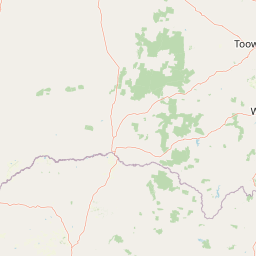
Map view of Wondul Range National Park

Use this park location map to pinpoint Wondul Range National Park in Australia, understand its exact geographic position, and read its mapped placement within the surrounding landscape more clearly.

Pigeon | © OpenStreetMap contributors

Location context for Wondul Range National Park

Queensland
Park atlas

Explore Queensland's protected areas by geographic closeness and similar open woodland landscapes.

Discover Other National Parks and Protected Areas Near Wondul Range National Park
After exploring Wondul Range National Park, browse other protected areas within Queensland's Darling Downs and the broader Brigalow Belt bioregion. This curated list allows for geographic comparison of open woodland ecosystems and provides essential regional context for conservation landscapes, helping you trace connected park geography.
National parkGoondiwindi Region

Bendidee National Park: Protected Landscape and Geographic Context

National park within the Goondiwindi Region, Australia

Bendidee National Park serves as a key protected area in the Goondiwindi Region of Australia. This detail page provides an atlas-focused perspective, detailing the park's mapped geographic extent and its significance as a natural landscape. Gain structured insights into Bendidee National Park's protected status and its place within the broader regional geography for informed exploration.

Area
9.3 km²
Established
1979
IUCN
II
Relief
Lowland
National parkQueensland

Southwood National Park: Queensland Protected Area and National Park Atlas Entry

Mapped protected landscape and regional geographic context for Southwood National Park.

Southwood National Park serves as a vital component of Queensland's protected lands network, offering a focused view for atlas exploration. Users can examine its specific mapped boundaries and understand its role within the broader geographic context of northeastern Australia. This detailed entry supports structured discovery of the park's natural landscape and its significance as a national park.

Area
71.2 km²
Established
1970
Relief
Lowland
Climate
Arid
National parkSouthern Downs Region

Sundown National Park: National Park with Mapped Protected Boundaries

Southern Downs Region's Protected Landscape Geography

Investigate Sundown National Park, a designated national park in Australia's Southern Downs Region. This resource details its protected landscape identity and geographic setting, offering precise information on its mapped boundaries and regional context for atlas exploration and understanding its conservation value.

Area
160 km²
Established
1977
IUCN
II
Relief
Mountain
National parkNew South Wales

Maryland National Park: A Detailed Map and Protected Landscape Overview

Explore the geography and mapped boundaries of this national park.

Maryland National Park represents a distinct protected area within New South Wales, Australia, offering rich geographic context for exploration. This page details its role as a national park, focusing on its mapped terrain, landscape character, and position within the regional geography. Users seeking to understand the park's protected boundaries and natural setting will find valuable atlas-style information here, providing a concrete foundation for further geographic study.

Area
9 km²
Established
1999
IUCN
Ia
Relief
Upland
National parkQueensland

Girraween National Park: Queensland's Protected National Park Landscape for Atlas Exploration

Mapped geography and protected natural terrain.

Delve into Girraween National Park, a significant protected national park located in Queensland, Australia. This detailed entry provides essential information for understanding its geographic features, mapped boundaries, and the unique natural landscape it preserves. Discover how Girraween National Park fits into the wider Australian atlas and explore its specific regional geography and protected land context.

Area
117 km²
Established
1966
IUCN
II
Relief
Mountain
Watercolor painting of a river flowing between rocky cliffs with forest in the background
National parkNew South Wales

Kwiambal National Park: New South Wales National Park with Granite Landscapes and River Confluence

Explore the dramatic scenery of MacIntyre Falls and surrounding protected terrain.

Kwiambal National Park is a significant protected area in New South Wales, Australia, celebrated for its unique granite outcrops and the spectacular confluence of the Severn and Macintyre Rivers at MacIntyre Falls. This national park provides a clear example of regional protected landscape identity, offering valuable context for atlas-driven discovery of Australia's natural geography and mapped terrain. The park's distinctive features contribute to its importance as a conservation reserve within the New England region.

Area
65.17 km²
Established
2000
IUCN
II
Scope
Terrestrial
National parkNew South Wales

Bald Rock National Park: Detailed National Park Atlas and Protected Landscape Context

Explore its mapped boundaries and natural terrain within New South Wales.

Bald Rock National Park serves as a key protected area for understanding regional geography and mapped landscapes in New South Wales. This page offers an atlas-centric view of the park, detailing its protected boundaries and providing context for its natural terrain. It is designed for users seeking structured information about national parks and their geographic significance, contributing to a comprehensive understanding of Australia's conservation lands.

Area
88.83 km²
Established
1971
IUCN
II
Relief
Mountain
National parkQueensland

Lockyer National Park: A National Park in Queensland with Distinct Geographic Features

Mapped protected boundaries and regional landscape context.

Lockyer National Park is a designated national park providing a critical lens into Queensland's varied geography and protected landscapes. Understanding this park involves exploring its mapped boundaries and how it contributes to the region's natural terrain. This entry serves as a detailed geographic context for Lockyer National Park, supporting structured discovery within the Australian state's protected areas.

Area
110.79 km²
Established
2008
IUCN
II
Relief
Mountain

Common questions about visiting, size, designation, and location context for Wondul Range National Park

Wondul Range National Park FAQs for park facts, access, geography, and protected area context
Find quick answers about Wondul Range National Park, including protected-area facts, park geography, trail and visitor context, and how the park fits into its surrounding country and regional landscape.
MoriAtlas Explorer

Continue Your Protected Areas Search Across the Global Atlas

Deepen your exploration by continuing the structured search for national parks and protected areas worldwide. Utilize the comprehensive filtering capabilities to compare different conservation landscapes and refine your understanding of global park geography. Discover more about the distribution and characteristics of protected natural areas.

Global natural geography