

Mori Atlas logo
National parkSouthwood National Park

Explore the mapped protected area and natural terrain of Southwood National Park, Queensland.

Southwood National Park: Queensland National Park Atlas and Geographic Landscape Context

Southwood National Park represents a significant protected area within the diverse geography of Queensland, Australia. As a designated national park, it offers a crucial point for exploring mapped boundaries and understanding the regional landscape context. This detailed atlas entry helps visualize its place within the natural terrain and contributes to a structured understanding of protected lands in northeastern Australia.

Brigalow-belah forestQueensland national parksDarling DownsSemi-arid woodlandsBirdwatchingGilgai depressions

Southwood National Park

National park

Park overview

Structured park overview, official facts, and landscape profile for Southwood National Park

Southwood National Park park facts, protected area profile, and essential visitor context
Review the core facts for Southwood National Park, including designation, size, terrain, visitor scale, habitats, and operating context in one park-focused overview.

About Southwood National Park

Southwood National Park occupies a significant ecological niche on the western edge of the Darling Downs, protecting relict forest communities in a region where the native vegetation has been extensively cleared for grazing and cropping. The park's scrubby forests are dominated by brigalow and belah, with an understory of species including cypress pine, poplar box, wilga bush, false sandalwood, and western teatree. These woodlands provide critical habitat for wildlife in an otherwise heavily modified landscape, serving as islands of biodiversity amidst agricultural land. The presence of large depressions known as gilgais scattered throughout the park adds to its ecological complexity, these features forming through the constant wetting and drying cycles of the region's heavy clay soils. Beyond its ecological value, Southwood holds cultural significance as the traditional land of the Bigambul people, an Aboriginal group whose connection to this landscape predates European settlement.

Quick facts and research context for Southwood National Park

Southwood National Park lies on the western Darling Downs in southern Queensland, protecting remnants of brigalow-belah forest that once covered much of this region. The park is managed by the Queensland Parks and Wildlife Service and was officially declared in 1970, though the area was previously known as Wild Horse Paradise. The landscape features scrubby forests with species including cypress pine, poplar box, and wilga bush, interspersed with distinctive gilgai depressions formed by the repeated wetting and drying of heavy clay soils. The park supports more than 92 bird species, including the wonga pigeon at the inland limit of its range.

Park context

Deeper park guide and search-rich context for Southwood National Park

Southwood National Park history, landscape, wildlife, and travel context
Explore Southwood National Park through its history, landscape character, ecosystems, wildlife, conservation priorities, cultural context, and seasonal travel timing in a structured park guide built for atlas discovery and search intent.

Why Southwood National Park stands out

Southwood National Park is best known for preserving some of the finest remaining examples of brigalow-belah forest on the Darling Downs, a vegetation type that has been drastically reduced across its former range by agricultural development. These forest remnants, characterized by a complex mix of brigalow (Acacia harpophylla) and belah (Casuarina cristata) trees, represent what few intact examples remain of this once extensive community. The park also serves as an important refuge for wildlife in a largely cleared landscape, with more than 92 bird species recorded within its boundaries.

Southwood National Park history and protected-area timeline

The area now comprising Southwood National Park was historically known as Wild Horse Paradise, reflecting its use as a gathering point for wild horses in the colonial period. European explorers Allan Cunningham and Thomas Mitchell passed through this region during their expeditions across inland Queensland, though the surrounding area developed slowly and remained sparsely settled compared to other parts of the Darling Downs. The land was eventually set aside for protection and formally established as a national park in 1970 under the management of what is now the Queensland Parks and Wildlife Service. This declaration came at a time of growing recognition of the need to preserve remaining fragments of the brigalow-belah forest, which had been systematically cleared across most of its former range.

Southwood National Park landscape and geographic character

The landscape of Southwood National Park is characterised by gentle undulating terrain supporting scrubby forest and woodland communities. The vegetation is dominated by brigalow-belah forest, a distinctive semi-arid woodland type featuring dense stands of brigalow (a tall shrub or small tree) intermingled with belah (a she-oak species). The park's floor is dotted with gilgais, which are shallow depressions formed by the swelling and shrinking of clay soils during wet and dry cycles. These depressions create microhabitats within the broader forest system and contribute to the park's ecological diversity. The overall appearance is one of semi-open woodland with a scrubby understory, typical of the western Darling Downs environment.

Southwood National Park ecosystems, habitats, and plant life

The brigalow-belah forest of Southwood represents one of the most significant vegetation types protected within the park. This community once dominated extensive areas of the Darling Downs but has been dramatically reduced by clearing for agriculture, making the remaining stands at Southwood increasingly precious. The forest supports a diverse mix of plant species including cypress pine, poplar box, wilga bush, false sandalwood, and western teatree, creating a layered ecosystem with distinct canopy and understory zones. The gilgai depressions add further ecological variety, creating different moisture regimes and supporting plant species adapted to periodic inundation. This combination of vegetation types and microhabitats forms the basis of the park's ecological character.

Southwood National Park wildlife and species highlights

Southwood National Park serves as an important wildlife refuge in a largely cleared agricultural landscape, with more than 92 bird species recorded within its boundaries. The wonga pigeon reaches the inland limit of its range in this area, making Southwood a notable location for observing this species in a semi-arid setting. The forest and woodland habitats support a variety of birdlife, while the gilgai depressions provide additional resources for wildlife, particularly during dry periods when water availability becomes limited. The park's value as a refuge is amplified by the surrounding land use, as the remnant forest patches represent critical habitat stepping stones for wildlife movement across the broader landscape.

Southwood National Park conservation status and protection priorities

Southwood National Park plays a vital conservation role by protecting some of the last remaining intact examples of brigalow-belah forest on the Darling Downs. This vegetation type has been drastically reduced across its historical range, with few substantial remnants surviving outside protected areas. The park preserves not only the forest structure but also the associated biodiversity that depends on these woodlands, including numerous bird species and other fauna. Given the extent of clearing across the Darling Downs, Southwood's protected forests represent a significant conservation asset, maintaining ecological connectivity and habitat diversity in a heavily modified region.

Southwood National Park cultural meaning and human context

Southwood National Park lies within the traditional Country of the Bigambul people, an Aboriginal Australian group with deep historical connections to the Darling Downs landscape. The area's cultural significance predates European exploration and settlement, though the specific traditional uses and practices of the Bigambul people in this particular area are not extensively documented in the available sources. European explorers Allan Cunningham and Thomas Mitchell both passed through the region during the nineteenth century, but the western Darling Downs developed slowly compared to other parts of Queensland, leaving the natural landscape relatively intact until the establishment of the national park in 1970.

Top sights and standout views in Southwood National Park

The remnant brigalow-belah forest at Southwood represents the park's most significant feature, preserving a vegetation type that has been largely eliminated from the broader Darling Downs landscape. The bird diversity, with more than 92 species recorded including the wonga pigeon at its inland range limit, demonstrates the park's ecological importance as a wildlife refuge. The gilgai depressions add visual and ecological variety to the landscape, while the park's location on the western edge of the Darling Downs places it at the transition between different environmental zones.

Best time to visit Southwood National Park

The cooler months from autumn through spring typically offer the most comfortable conditions for exploring Southwood National Park, with milder temperatures making extended walks through the woodland more pleasant. Winter and early spring can bring pleasant weather, though the semi-arid climate means conditions can vary significantly between years. The park's wildlife viewing opportunities remain available throughout the year, though bird activity may be more concentrated around water sources during dryer periods.
Park location guide

Geography guide, regional context, and park location map for Southwood National Park

Southwood National Park park geography, regions, and map view in Australia
Understand where Southwood National Park sits in Australia through a broader geographic reading of the surrounding landscape, nearby location context, and its mapped position within the national park landscape.

How Southwood National Park fits into Australia

Australia is a constitutional monarchy and federal parliamentary democracy comprising six states and ten territories. With a population of nearly 28 million, it is one of the world's most urbanised countries, with most people concentrated on the eastern seaboard. The country has a high Human Development Index and is known for its cultural diversity, ancient Aboriginal heritage, and unique wildlife.

Wider geography shaping Southwood National Park in Australia

Australia occupies the entire Australian continent, the island of Tasmania, and numerous smaller islands. It is the world's flattest and driest inhabited continent, featuring vast deserts in the interior (the Outback), tropical rainforests along the eastern coast, and a coastline bordering the Indian and Pacific Oceans.

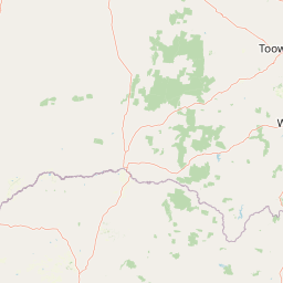
Map view of Southwood National Park

Use this park location map to pinpoint Southwood National Park in Australia, understand its exact geographic position, and read its mapped placement within the surrounding landscape more clearly.

Pigeon | © OpenStreetMap contributors

Location context for Southwood National Park

Queensland
Park atlas

Trace the geographic spread of protected areas and compare conservation landscapes across the Darling Downs region.

Explore Other National Parks and Protected Areas Near Southwood National Park, Darling Downs
After exploring Southwood National Park's unique brigalow-belah forests, browse other national parks and protected areas within Queensland's Darling Downs region. This geographic overview reveals the distribution of conservation landscapes, enabling comparison of diverse woodland types and regional protected area spread.
National parkGoondiwindi Region

Bendidee National Park: Protected Landscape and Geographic Context

National park within the Goondiwindi Region, Australia

Bendidee National Park serves as a key protected area in the Goondiwindi Region of Australia. This detail page provides an atlas-focused perspective, detailing the park's mapped geographic extent and its significance as a natural landscape. Gain structured insights into Bendidee National Park's protected status and its place within the broader regional geography for informed exploration.

Area
9.3 km²
Established
1979
IUCN
II
Relief
Lowland
National parkQueensland

Erringibba National Park National Park: A Protected Landscape in Queensland's Atlas

Mapped boundaries and regional geographic context for this protected area.

Erringibba National Park, designated as a national park in Queensland, Australia, offers specific insights into protected landscapes and their geographic significance. This entry focuses on understanding the park's mapped features and its contribution to the regional atlas. Users can explore its identity as a protected area, providing a foundation for comprehending its natural landscape within the broader context of Queensland's diverse geography. This is essential for anyone seeking detailed geographic context on Australia's protected natural areas.

Area
8.77 km²
Established
1999
IUCN
II
Relief
Lowland
National parkQueensland

Alton National Park: Discover Protected Landscape and Geographic Setting in Queensland

Explore the mapped boundaries and regional context of this national park.

Alton National Park is a key protected natural landscape within Queensland, Australia. This dedicated page focuses on its identity as a national park, providing clear geographic context and mapped outlines. Explore how Alton National Park contributes to the protected areas of northeastern Australia, offering valuable insights for atlas-based discovery of diverse terrains and conservation landscapes.

Area
5.58 km²
Established
1973
IUCN
II
Relief
Lowland
National parkQueensland

Wondul Range National Park: Queensland Protected Area and Landscape Mapping

Discover the geographic context and mapped boundaries.

Wondul Range National Park offers a unique protected landscape within Queensland, Australia, serving as a key point for geographic and atlas-based exploration. Delve into its specific regional context, understand its mapped park boundaries, and appreciate its role as a designated national park. This entry provides detailed insights into its natural geography and protected-area significance for comprehensive landscape discovery.

Area
35.55 km²
Established
1992
IUCN
II
Scope
Terrestrial
Watercolor painting of a river flowing between rocky cliffs with forest in the background
National parkNew South Wales

Kwiambal National Park: New South Wales National Park with Granite Landscapes and River Confluence

Explore the dramatic scenery of MacIntyre Falls and surrounding protected terrain.

Kwiambal National Park is a significant protected area in New South Wales, Australia, celebrated for its unique granite outcrops and the spectacular confluence of the Severn and Macintyre Rivers at MacIntyre Falls. This national park provides a clear example of regional protected landscape identity, offering valuable context for atlas-driven discovery of Australia's natural geography and mapped terrain. The park's distinctive features contribute to its importance as a conservation reserve within the New England region.

Area
65.17 km²
Established
2000
IUCN
II
Scope
Terrestrial
National parkQueensland

Bunya Mountains National Park: Queensland's Protected National Park Landscape

Mapped terrain and regional geography within Queensland.

Investigate Bunya Mountains National Park as a primary protected area within Queensland, Australia. This entry provides essential context for its landscape character, geographic placement, and its role in the national atlas of conservation lands. Understanding its mapped boundaries and unique terrain helps delineate its specific contribution to the protected geography of northeastern Australia.

Area
117 km²
Established
1908
IUCN
II
Relief
Mountain
National parkSouthern Downs Region

Sundown National Park: National Park with Mapped Protected Boundaries

Southern Downs Region's Protected Landscape Geography

Investigate Sundown National Park, a designated national park in Australia's Southern Downs Region. This resource details its protected landscape identity and geographic setting, offering precise information on its mapped boundaries and regional context for atlas exploration and understanding its conservation value.

Area
160 km²
Established
1977
IUCN
II
Relief
Mountain
National parkToowoomba Region

The Palms National Park: National Park Atlas and Mapped Landscape Context

Explore its geographic setting and protected area features.

The Palms National Park, designated as a national park within Australia's Toowoomba Region, provides a specific focus for atlas-based geographic exploration. Understanding this protected area involves appreciating its unique landscape characteristics and its position within the broader regional geography. This entry highlights the park's mapped boundaries and its role in a structured overview of natural landscapes, offering valuable context for researchers and explorers focused on protected lands.

Area
0.124 km²
Established
1950
IUCN
II
Relief
Lowland

Common questions about visiting, size, designation, and location context for Southwood National Park

Southwood National Park FAQs for park facts, access, geography, and protected area context
Find quick answers about Southwood National Park, including protected-area facts, park geography, trail and visitor context, and how the park fits into its surrounding country and regional landscape.
MoriAtlas Explorer

Continue Your Protected Areas Search Across the Global Atlas

Deepen your exploration by continuing the structured search for national parks and protected areas worldwide. Utilize the comprehensive filtering capabilities to compare different conservation landscapes and refine your understanding of global park geography. Discover more about the distribution and characteristics of protected natural areas.

Global natural geography