

Mori Atlas logo
National parkErringibba National Park

Explore the geographic setting and protected boundaries of Erringibba National Park.

Erringibba National Park: Queensland's National Park for Mapped Protected Landscape Discovery

Erringibba National Park stands as a significant protected area within Queensland, Australia, offering a unique lens for geographic exploration. As a designated national park, it represents a distinct natural landscape whose mapped boundaries contribute to the broader atlas of Australian protected lands. This page provides context for understanding the park's place within Queensland's diverse geography, aiding users in comprehending its protected-area identity and landscape characteristics through map-driven discovery.

National ParkQueenslandBrigalow WoodlandEndangered EcosystemsDarling DownsProtected Area

Erringibba National Park

National park

Park overview

Structured park overview, official facts, and landscape profile for Erringibba National Park

Erringibba National Park park facts, protected area profile, and essential visitor context
Review the core facts for Erringibba National Park, including designation, size, terrain, visitor scale, habitats, and operating context in one park-focused overview.

About Erringibba National Park

Erringibba National Park represents a conserved remnant of the once-extensive brigalow and belah woodlands that characterised the Darling Downs region's clay plains before widespread European settlement. The park was formally established in 1999 as a protected area managed by the Queensland Parks and Wildlife Service, with the specific aim of preserving these endangered ecosystems that have survived only in isolated patches across the landscape. The surrounding region has been heavily transformed by agricultural activities, particularly cropping and livestock grazing, leaving the park as a critical refuge for native vegetation that has been eliminated from most of the surrounding countryside. The park's location within the Condamine River catchment connects it to broader hydrological systems in southern Queensland, though the landscape itself is flat and largely lacking in prominent topographic features.

Quick facts and research context for Erringibba National Park

Erringibba National Park is situated in southern Queensland, Australia, near Glenmorgan in the Darling Downs region. The 8.77 square kilometre park was established in 1999 by the Queensland Parks and Wildlife Service. The landscape consists of flat clay plains supporting open forest communities dominated by brigalow (Acacia harpophylla) and belah (Casuarina cristata). The park protects two endangered ecosystem types that have been largely eliminated from the surrounding agricultural landscape. Four rare or threatened species have been recorded within the park boundaries.

Park context

Deeper park guide and search-rich context for Erringibba National Park

Erringibba National Park history, landscape, wildlife, and travel context
Explore Erringibba National Park through its history, landscape character, ecosystems, wildlife, conservation priorities, cultural context, and seasonal travel timing in a structured park guide built for atlas discovery and search intent.

Why Erringibba National Park stands out

Erringibba National Park is best known for its role in protecting two endangered woodland ecosystems that were once widespread across the Queensland clay plains but are now critically diminished. The park conserves brigalow open forest dominated by Acacia harpophylla and Casuarina cristata on Cainozoic clay plains, as well as poplar gum (Eucalyptus populnea) open forest and woodland with associated brigalow and belah. These vegetation communities have been mostly cleared for agriculture across the broader Brigalow Belt, making the park's remaining examples particularly significant for biodiversity conservation.

Erringibba National Park history and protected-area timeline

Erringibba National Park was established in 1999 as part of Queensland's protected area network expansion during the late 1990s. The park's creation reflected growing recognition of the conservation significance of the brigalow belt woodlands, which had suffered extensive clearing across their former range. The decision to protect this particular area was motivated by the presence of relatively intact examples of two endangered ecosystem types that had been largely cleared from private land across the region. The Queensland Parks and Wildlife Service assumed management responsibility for the park, implementing protection measures aimed at maintaining the integrity of the remaining woodland communities and the species they support.

Erringibba National Park landscape and geographic character

The terrain of Erringibba National Park is characterised by flat, gently undulating clay plains typical of the western Darling Downs. The average elevation of the park is approximately 294 metres above sea level, with minimal topographic variation across its 8.77 square kilometre extent. The landscape supports open forest and woodland vegetation, with the canopy dominated by brigalow (Acacia harpophylla) and belah (Casuarina cristata) trees. These species form distinctive woodland communities that are adapted to the clay-rich soils of the region. The flat topography and the interconnected nature of the vegetation communities create a relatively uniform landscape character across the park.

Erringibba National Park ecosystems, habitats, and plant life

The ecological significance of Erringibba National Park lies in its preservation of endangered vegetation communities that have been extensively cleared from the broader Brigalow Belt South bioregion. The park protects two distinct ecosystem types: shrubby open forest dominated by Acacia harpophylla and Casuarina cristata on Cainozoic clay plains, and open forest to woodland of Eucalyptus populnea with associated brigalow and belah on similar terrain. These communities represent the remnants of once-extensive woodlands that covered much of the Queensland clay plains before agricultural development transformed the landscape. The park provides crucial habitat for native species in a landscape where most native vegetation has been removed.

Erringibba National Park wildlife and species highlights

Four rare or threatened species have been identified within Erringibba National Park, highlighting the importance of the protected area for biodiversity conservation. The park's woodland communities provide habitat for various native fauna species that depend on the intact vegetation cover and the resources it provides. While the source material does not specify the exact species present, the presence of threatened species indicates the ecological value of preserving these remnant woodland areas. The park serves as a refuge for wildlife in a region where extensive land clearing has eliminated much of the original habitat.

Erringibba National Park conservation status and protection priorities

Erringibba National Park plays a vital conservation role by protecting two endangered ecosystem types that have been mostly cleared from the Queensland landscape for agricultural purposes. The brigalow and belah open forest communities that the park preserves represent some of the last remaining examples of these vegetation types in relatively intact condition. These ecosystems are recognised as endangered due to the extensive clearing across their former range, with the Brigalow Belt South bioregion having been transformed by farming and grazing activities. The park contributes to the preservation of biodiversity by maintaining habitat for rare and threatened species and preserving the ecological character of the Darling Downs region.

Top sights and standout views in Erringibba National Park

Erringibba National Park protects some of the last remaining intact examples of brigalow and belah woodland in the Queensland Darling Downs. The park's conservation focus on two endangered ecosystem types makes it significant for regional biodiversity. The flat clay plain landscape supports distinctive open forest communities that have been mostly eliminated from surrounding agricultural land. The park provides ecological connectivity within the broader Brigalow Belt South landscape and supports at least four threatened species.

Best time to visit Erringibba National Park

Erringibba National Park can be visited year-round given its location in southern Queensland. The cooler winter months from May to September typically offer more comfortable conditions for exploring the park, with milder daytime temperatures and lower humidity. Summer months can be hot and humid in the Darling Downs region. The park's small size and the nature of its attractions mean that seasonal variations in scenery are relatively subtle compared to more climatically diverse parks.
Park location guide

Geography guide, regional context, and park location map for Erringibba National Park

Erringibba National Park park geography, regions, and map view in Australia
Understand where Erringibba National Park sits in Australia through a broader geographic reading of the surrounding landscape, nearby location context, and its mapped position within the national park landscape.

How Erringibba National Park fits into Australia

Australia is a constitutional monarchy and federal parliamentary democracy comprising six states and ten territories. With a population of nearly 28 million, it is one of the world's most urbanised countries, with most people concentrated on the eastern seaboard. The country has a high Human Development Index and is known for its cultural diversity, ancient Aboriginal heritage, and unique wildlife.

Wider geography shaping Erringibba National Park in Australia

Australia occupies the entire Australian continent, the island of Tasmania, and numerous smaller islands. It is the world's flattest and driest inhabited continent, featuring vast deserts in the interior (the Outback), tropical rainforests along the eastern coast, and a coastline bordering the Indian and Pacific Oceans.

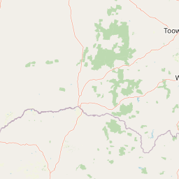
Map view of Erringibba National Park

Use this park location map to pinpoint Erringibba National Park in Australia, understand its exact geographic position, and read its mapped placement within the surrounding landscape more clearly.

Pigeon | © OpenStreetMap contributors

Location context for Erringibba National Park

Queensland
Park atlas

Trace the regional spread of protected landscapes across the Darling Downs bioregion and Queensland's Brigalow Belt.

Explore Other National Parks and Protected Areas Near Erringibba National Park in Queensland
After exploring Erringibba National Park, browse other national parks and protected areas across Queensland's Darling Downs region, focusing on similar remnant woodland ecosystems. Compare adjacent protected landscapes and trace the geographic spread of critical conservation efforts within the broader Brigalow Belt bioregion and beyond.
National parkQueensland

Southwood National Park: Queensland Protected Area and National Park Atlas Entry

Mapped protected landscape and regional geographic context for Southwood National Park.

Southwood National Park serves as a vital component of Queensland's protected lands network, offering a focused view for atlas exploration. Users can examine its specific mapped boundaries and understand its role within the broader geographic context of northeastern Australia. This detailed entry supports structured discovery of the park's natural landscape and its significance as a national park.

Area
71.2 km²
Established
1970
Relief
Lowland
Climate
Arid
National parkQueensland

Alton National Park: Discover Protected Landscape and Geographic Setting in Queensland

Explore the mapped boundaries and regional context of this national park.

Alton National Park is a key protected natural landscape within Queensland, Australia. This dedicated page focuses on its identity as a national park, providing clear geographic context and mapped outlines. Explore how Alton National Park contributes to the protected areas of northeastern Australia, offering valuable insights for atlas-based discovery of diverse terrains and conservation landscapes.

Area
5.58 km²
Established
1973
IUCN
II
Relief
Lowland
National parkGoondiwindi Region

Bendidee National Park: Protected Landscape and Geographic Context

National park within the Goondiwindi Region, Australia

Bendidee National Park serves as a key protected area in the Goondiwindi Region of Australia. This detail page provides an atlas-focused perspective, detailing the park's mapped geographic extent and its significance as a natural landscape. Gain structured insights into Bendidee National Park's protected status and its place within the broader regional geography for informed exploration.

Area
9.3 km²
Established
1979
IUCN
II
Relief
Lowland
National parkQueensland

Wondul Range National Park: Queensland Protected Area and Landscape Mapping

Discover the geographic context and mapped boundaries.

Wondul Range National Park offers a unique protected landscape within Queensland, Australia, serving as a key point for geographic and atlas-based exploration. Delve into its specific regional context, understand its mapped park boundaries, and appreciate its role as a designated national park. This entry provides detailed insights into its natural geography and protected-area significance for comprehensive landscape discovery.

Area
35.55 km²
Established
1992
IUCN
II
Scope
Terrestrial
National parkQueensland

Bunya Mountains National Park: Queensland's Protected National Park Landscape

Mapped terrain and regional geography within Queensland.

Investigate Bunya Mountains National Park as a primary protected area within Queensland, Australia. This entry provides essential context for its landscape character, geographic placement, and its role in the national atlas of conservation lands. Understanding its mapped boundaries and unique terrain helps delineate its specific contribution to the protected geography of northeastern Australia.

Area
117 km²
Established
1908
IUCN
II
Relief
Mountain
National parkQueensland

Thrushton National Park: Queensland's Mulga Lands National Park and Protected Landscape

Explore the semi-arid terrain and mapped conservation boundaries.

Thrushton National Park represents a crucial protected landscape within Queensland's Mulga Lands, preserving vast expanses of dense mulga scrub, spinifex sandplains, and dry woodlands. As a National Park, it offers a unique window into the semi-arid ecology of inland Australia, characterized by its subtly undulating terrain and sandy soils. This atlas-focused exploration highlights the park's distinctive vegetation communities and its regional geographic significance, providing a factual base for understanding this vital conservation area.

Area
256.52 km²
Established
1990
IUCN
II
Scope
Terrestrial
National parkQueensland

Beeron National Park: National Park Protected Landscape in Queensland, Australia

Discover its geographic context and mapped natural terrain.

Delve into Beeron National Park, a distinct national park located in Queensland, Australia. This protected area offers a unique perspective on the region's natural landscapes and geography. By examining its mapped boundaries and its position within Queensland's broader environmental context, users can gain a structured understanding of this significant conservation landscape.

Area
70.5 km²
Established
2009
IUCN
II
Scope
Terrestrial
National parkToowoomba Region

The Palms National Park: National Park Atlas and Mapped Landscape Context

Explore its geographic setting and protected area features.

The Palms National Park, designated as a national park within Australia's Toowoomba Region, provides a specific focus for atlas-based geographic exploration. Understanding this protected area involves appreciating its unique landscape characteristics and its position within the broader regional geography. This entry highlights the park's mapped boundaries and its role in a structured overview of natural landscapes, offering valuable context for researchers and explorers focused on protected lands.

Area
0.124 km²
Established
1950
IUCN
II
Relief
Lowland

Common questions about visiting, size, designation, and location context for Erringibba National Park

Erringibba National Park FAQs for park facts, access, geography, and protected area context
Find quick answers about Erringibba National Park, including protected-area facts, park geography, trail and visitor context, and how the park fits into its surrounding country and regional landscape.
MoriAtlas Explorer

Continue Your Protected Areas Search Across the Global Atlas

Deepen your exploration by continuing the structured search for national parks and protected areas worldwide. Utilize the comprehensive filtering capabilities to compare different conservation landscapes and refine your understanding of global park geography. Discover more about the distribution and characteristics of protected natural areas.

Global natural geography