
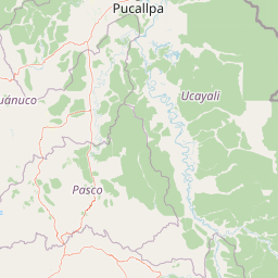
Rivers
Park geography
Mapped boundaries, terrain elevation profiles, and regional physical landscape data
Comprehensive Geographic Profile of Yanachaga–Chemillén National Park in the Pasco Region
This structured geographic profile details the physical scope and environmental characteristics of Yanachaga–Chemillén National Park. Examine the 1220 square kilometer territory, which spans from 460 to 3643 meters in elevation through mountain, canyon, and forest systems. Data includes the recorded regional location, boundary perimeter, and distribution of internal water and natural features.
Related tags
Cloud ForestPleistocene RefugeBirdwatchingPeruPasco Region
Peru's cloud forest sanctuary preserving Amazonian biodiversity in a Pleistocene refuge
Yanachaga, Chemillén National Park
Yanachaga–Chemillén National Park is a protected area located in the Pasco Region of central Peru, established in 1986 to preserve the rainforests and cloud forests of the Yanachaga mountain range. The park encompasses approximately 122,000 hectares of rugged mountain terrain, with elevations ranging from 460 to 3,643 meters above sea level. This extraordinary altitudinal span, combined with the region's complex topography of deep canyons and steep forested slopes, creates a remarkable diversity of ecological formations within a relatively compact geographic area. The park is recognized as a Pleistocene refuge, meaning it harbors relict forests that survived the severe climatic fluctuations of the Pleistocene epoch, explaining the exceptional biological diversity found within its boundaries. The Yanachaga–Chemillén area represents one of the most biologically significant protected regions in central Peru, providing crucial habitat for numerous species, including several that are endemic to this particular biogeographic zone.
- Location
- Peru
- Park type
- National park
- Established
- 1986
- Area
- 1,220 km²
- Highest point
- 3,643 m
Location overview
Administrative boundaries and regional placement in South America
Mapping the Geography of Yanachaga Chemillen National Park
Yanachaga Chemillen National Park is situated within the Pasco Region with recorded ties to Peru and Argentina. Map records confirm a purely interior, mainland territory with no coastal or marine boundaries.
- Countries
- Peru
- Regions
- Pasco Region
- Primary location
- Pasco Region
- Geographic setting
- Inland
Boundary and coordinates
Mapped perimeter geometry, geographic span, and area measurements
Yanachaga–Chemillén National Park Boundary Map and Spatial Extent
Interactive boundary mapping outlines the spatial footprint for spatial context. Accompanying factual metrics detail the recorded area spanning twelve hundred twenty square kilometers alongside coordinate limits.
- Boundary area
- 1,134.4 km²
- Boundary perimeter
- 215.6 km
- Northernmost point
- 10.1664° S
- Southernmost point
- 10.6084° S
- Easternmost point
- 75.1208° W
- Westernmost point
- 75.6809° W
- Geographic centre
- 10.3699° S, 75.4027° W
- North–south span
- 48.9 km
- East–west span
- 61.3 km
Elevation and terrain
Vertical range data and recorded natural features across protected mountain terrain
Yanachaga–Chemillén National Park Elevation Profile and Mapped Terrain Features
Recorded elevation ranges span from four hundred sixty meters to three thousand six hundred forty-three meters across mountain terrain. Mapped natural feature cards detail rivers, streams, and peaks located within the protected area boundaries.
- Minimum elevation
- 460 m
- Maximum elevation
- 3,643 m
- Highest point
- 3,643 m
Selected named natural features
Rivers
Rio Huancabamba
Peaks
Abra la Esperanza
3,600 m
Rivers
Chuchuras
Streams
Quebrada La Esperanza
Streams
Yanachaga
Environmental setting
Analysis of tropical relief, forest cover, and habitat classifications
Yanachaga–Chemillén National Park Environmental Setting and Landscape Classifications
Stored classifications combine mountain relief, tropical climate zones, and forest cover into complementary categories for physical terrain analysis. Recorded attributes connect directly to corresponding atlas destinations and regional environmental data.
- Relief
- Mountain
- Climate
- Tropical
- Water
- Major water bodies
- Forest cover
- Dense forest cover
- Seasonality
- Year-round
Landscape features
Mountains · Forest · Canyon · Cliffs · Rivers · Grassland
Habitat types
Tropical forest · Montane forest · Alpine meadow
Park atlas
Compare protected landscapes and trace their geographic spread across Peru's central cloud forest and mountain regions.
Explore Nearby National Parks and Protected Areas Surrounding Yanachaga–Chemillén National Park
Continue your exploration from Yanachaga–Chemillén National Park by browsing other national parks and protected areas located in Peru's Pasco Region and adjacent Andean ecosystems. Deepen your understanding of regional park geography, comparing diverse mountain forests, cloud forest biomes, and connected conservation landscapes.

Protected areaPasco Region
Park boundaries overlap#1 closest
Southeast

San Matías, San Carlos Protection Forest: Geographic Boundaries and Protected Landscape Context
A vital watershed corridor in the Pasco Region of central Peru.
San Matías, San Carlos Protection Forest protects fragile mountain soils and downstream infrastructure from erosion and flooding. Stretching from 300 to 2,250 metres in elevation, the reserve supports a continuous block of highland habitat that serves as a bridge between the Peruvian Yungas and Ucayali moist forest ecoregions, while acting as a cornerstone of the Oxapampa-Asháninka-Yánesha Biosphere Reserve.
- Area
- 1,458 km²
- Established
- 1987
- IUCN
- VI
- Relief
- Mountain
Protected areaOxapampa Province
Park boundaries overlap#2 closest
Northeast
Yanesha Communal Reserve: Geography and Protected Area Context in Oxapampa Province
A vital transition zone between the Andes and the Amazon
Gain insight into the physical character of Yanesha Communal Reserve, where humid tropical forests and river channels converge to form a complex ecosystem. This protected area offers a look at how sustainable land use and conservation intersect within the Palcazu River basin. Browse the geographic boundaries and mapped landscape features that define this essential region in central Peru.
- Area
- 347.45 km²
- Established
- 1988
- IUCN
- VI
- Scope
- Terrestrial
Wildlife reservePeru
51 km away#3 closest
Northeast
El Sira Communal Reserve: Geographic Profile and Protected Landscape Context in Peru
Analyzing the Sira Mountain range and regional watershed boundaries
El Sira Communal Reserve sits at the intersection of the Andes and the Amazon, protecting a vast mosaic of habitats across Huánuco, Pasco, and Ucayali. Its geography is defined by deep river valleys, mountain ridges, and a significant altitudinal range that supports diverse wildlife communities. This resource provides a detailed look at the boundaries, terrain, and ecological importance of this major Peruvian protected area.
- Area
- 6,164.13 km²
- Established
- 2001
- IUCN
- VI
- Relief
- Mountain
National parkHuánuco Region
91 km away#4 closest
Northwest
Tingo María National Park: National Park Protected Landscape in Huánuco Region, Peru
Atlas exploration of park boundaries and regional geography.
Investigate Tingo María National Park, a key protected area situated in the Huánuco Region of Peru. This national park designation signifies its importance for understanding the country's natural landscapes and mapped geography. Explore its protected territory and discover its place within the regional atlas.
- Area
- 47.778 km²
- Established
- 1965
- IUCN
- II
- Relief
- Mountain
Nature reservePeru
118 km away#5 closest
West
Cordillera Huayhuash Reserved Zone: Protected Mountain Geography and Andean Watersheds
High-altitude glacial terrain in central Peru
Cordillera Huayhuash Reserved Zone comprises a dense concentration of glacial peaks and highland basins. As a major source of water for both the Pacific coast and the Amazon, this protected area represents a unique geographic crossroads where ice fields and alpine puna support critical regional ecosystems in the heart of the Andes.
- Area
- 675.9 km²
- Established
- 2002
- Relief
- Mountain
- Climate
- Alpine
Protected landscapeLima Region
134 km away#6 closest
South
Nor Yauyos-Cochas Landscape Reserve: Mapped Geography and Protected Andean Terrain
High-altitude glacial landscape and karst geology
Investigate the high-Andean environment of Nor Yauyos-Cochas Landscape Reserve, a protected area in the Lima Region spanning glacial lakes and deep valleys. Focus on the topographic diversity of the Pariacaca massif and the global significance of its subterranean karst features. This atlas provides a detailed spatial look at how these high-elevation ecosystems and traditional cultural landscapes integrate into the broader Peruvian geography.
- Area
- 2,212.68 km²
- Established
- 2001
- IUCN
- V
- Relief
- Mountain
National parkPeru
143 km away#7 closest
North
Cordillera Azul National Park: A National Park for Geographic Discovery in Peru
Explore Peru's protected landscape and regional map context.
Cordillera Azul National Park serves as a dedicated entry point for understanding Peru's protected natural areas through a geographic lens. This park's identity is tied to its specific mapped boundaries and its contribution to the nation's diverse terrain. Focusing on Cordillera Azul National Park allows for detailed atlas exploration of its unique landscape context within western South America, providing factual data for geographic understanding.
- Area
- 13,531.9 km²
- Established
- 2001
- IUCN
- II
- Relief
- Mountain
National parkPeru
148 km away#8 closest
Southeast
Otishi National Park: A Protected National Park Landscape in Peru's Geography
Explore the mapped boundaries and regional landscape of Otishi National Park.
Otishi National Park represents a significant protected area within Peru, offering a unique lens through which to explore regional geography and conservation landscapes. As a designated national park, it highlights the mapped boundaries and the natural terrain that defines this part of South America. Understanding Otishi National Park provides essential context for regional park discovery and the broader atlas of protected lands in Peru.
- Area
- 3,059.73 km²
- Established
- 2003
- IUCN
- II
- Relief
- Mountain
MoriAtlas Explorer
Continue exploring the protected geography and mapped landscapes of Yanachaga–Chemillén National Park
Deepen your understanding of Yanachaga–Chemillén National Park by delving into its specific geographic context and protected landscape features. This entry point facilitates structured exploration of its unique terrain, diverse ecosystems, and significance as a Pleistocene refuge within the Pasco Region's atlas. Continue your discovery to grasp the full scope of this protected natural area and its place within Peru's conservation geography.
Browse next
Global natural geography
Explore related park routes
Explore MoriAtlas Global ParksBrowse All MoriAtlas ParksGlobal Park Map DiscoveryMoriAtlas: Browse All CountriesBrowse All MoriAtlas ContinentsNational Park Environment AtlasGrand Canyon National Park AtlasYellowstone National Park AtlasYosemite National Park Atlas and GeographySerengeti National Park AtlasGalápagos National Park Protected LandscapeBanff National Park Geography and AtlasKruger National Park Atlas EntryUluṟu-Kata Tjuṯa National Park AtlasExplore Uluru-Kata Tjuta National Park GeographyPlitvice Lakes National Park AtlasFiordland National Park Protected LandscapeGreat Smoky Mountains National Park AtlasAfghanistan National Parks and Protected AreasAlbania National Parks and Protected AreasAlgeria National Parks and Protected AreasAmerican Samoa National Parks and Protected AreasAndorra National Parks and Protected AreasAngola National Parks and Protected AreasAntarctica National Parks and Protected AreasAntigua and Barbuda Park List