

Mori Atlas logo
National parkZapatera Archipelago National Park

Mapping the protected boundaries and regional geography of this vital Nicaraguan national park.

Zapatera Archipelago National Park: Nicaragua National Park Atlas and Protected Landscape

Zapatera Archipelago National Park represents a significant protected area within Nicaragua's diverse geography. As a national park, it offers critical insights into the region's natural landscapes and mapped terrain. This entry provides essential context for understanding the park's place within the atlas, focusing on its protected boundaries and its role in the broader geographic framework of Central America.

volcanic islandsLake NicaraguaCentral Americanational parkprotected areaisland ecosystems

Zapatera Archipelago National Park

National park

Park overview

Structured park overview, official facts, and landscape profile for Zapatera Archipelago National Park

Zapatera Archipelago National Park park facts, protected area profile, and essential visitor context

Review the core facts for Zapatera Archipelago National Park, including designation, size, terrain, visitor scale, habitats, and operating context in one park-focused overview.

About Zapatera Archipelago National Park

Zapatera Archipelago National Park protects a group of volcanic islands situated in Lake Nicaragua, the massive freshwater lake that dominates southwestern Nicaragua and forms part of the country's most significant hydrological system. The archipelago includes Zapatera Island as the largest and most prominent landmass, Isla el Muerto as a secondary island, and several smaller islets that complete the island cluster. These islands were formed through volcanic processes and their terrain reflects the geological history of volcanic activity in the Lake Nicaragua basin. The park's designation as a national park reflects Nicaragua's commitment to preserving the natural heritage represented by these islands, including their unique ecosystems, scenic values, and biodiversity. The lake setting creates a distinctive protected-area character, with the islands functioning as freshwater archipelago habitats rather than the coastal or mountain environments that dominate many other Central American protected areas.

Quick facts and research context for Zapatera Archipelago National Park

Zapatera Archipelago National Park is situated in the southern portion of Lake Nicaragua in southwestern Nicaragua. The protected area encompasses Zapatera Island as its primary landmass, along with the smaller Isla el Muerto and additional islets. The islands are of volcanic origin, rising from the waters of Central America's largest lake. The park is part of Nicaragua's system of protected areas designed to preserve the ecological and scenic values of the archipelago.

Protection and recognition

Verifying the documented conservation framework and official management scope within the archipelago.

Zapatera Archipelago National Park Protected Area Designation and Recognition Status

Protected-area status for Zapatera Archipelago National Park encompasses a mixed designation scope designed to safeguard both terrestrial and aquatic island ecosystems. Reviewing official database records provides essential geographic context for understanding regional conservation frameworks and island boundary limits.

Protection details

Protection scope
Mixed
Transboundary protection
No
Park context

Deeper park guide and search-rich context for Zapatera Archipelago National Park

Zapatera Archipelago National Park history, landscape, wildlife, and travel context

Explore Zapatera Archipelago National Park through its history, landscape character, ecosystems, wildlife, conservation priorities, cultural context, and seasonal travel timing in a structured park guide built for atlas discovery and search intent.

Why Zapatera Archipelago National Park stands out

Zapatera Archipelago National Park is best known for its volcanic island setting within Lake Nicaragua. The archipelago stands out as a lake-based protected area featuring islands of volcanic origin, distinct from Nicaragua's more common continental mountain and forest protected zones. Zapatera Island serves as the park's central focus, with its natural landscapes and island ecosystems providing the primary basis for the park's protected status and ecological significance.

Zapatera Archipelago National Park history and protected-area timeline

The specific establishment date and administrative history of Zapatera Archipelago National Park are not detailed in the available source material. The park exists as part of Nicaragua's broader framework of national parks and protected areas, which began developing substantially in the late twentieth century as the country established its system of environmental protection. The archipelago itself has historical significance as part of the Lake Nicaragua region, though detailed records of the park's creation and evolution are not provided in the current source.

Zapatera Archipelago National Park landscape and geographic character

The landscape of Zapatera Archipelago National Park is defined by its island setting within Lake Nicaragua. The islands feature volcanic terrain with elevations rising from the lake surface, creating a contrast between the open waters of the lake and the landforms of the islands. The terrain includes the characteristic shapes of volcanic islands, with slopes and ridgelines that mark the islands' geological origins. The surrounding lake waters form an essential part of the park's landscape character, with the archipelago appearing as a cluster of green islands set against the expanse of Central America's largest lake. The islets and smaller landforms add to the diversity of the island group.

Zapatera Archipelago National Park ecosystems, habitats, and plant life

The nature of Zapatera Archipelago National Park reflects its unique position as a lake-based island ecosystem. The islands support vegetation communities adapted to the island environment and the lacustrine setting. The freshwater lake environment surrounding the islands provides habitat conditions distinct from terrestrial or coastal ecosystems, while the islands themselves offer terrestrial habitats for various species. The combination of island land environments with the extensive lake ecosystem creates a diverse natural setting within the protected area.

Zapatera Archipelago National Park wildlife and species highlights

Specific wildlife details for Zapatera Archipelago National Park are not provided in the available source material. The island and lake setting would be expected to support birdlife associated with freshwater habitats and island environments, as well as terrestrial species adapted to the island ecosystems. However, detailed records of specific wildlife present in the park are not available from the current source.

Zapatera Archipelago National Park conservation status and protection priorities

Zapatera Archipelago National Park functions as a protected area within Nicaragua's national park system. The park's conservation purpose centers on preserving the volcanic island ecosystems and the natural values of the archipelago within Lake Nicaragua. The protected status provides legal framework for maintaining the islands' ecological integrity and preventing activities that could degrade their natural features. As a national park, it represents the country's recognition of the archipelago's significance as a natural area worthy of formal protection.

Zapatera Archipelago National Park cultural meaning and human context

The Zapatera Archipelago carries cultural significance within the context of Lake Nicaragua's regional history. The islands are named Zapatera, a name with roots in the region's Spanish colonial history and potentially reflecting historical uses or perceptions of the islands. The Lake Nicaragua basin has been an area of human settlement and activity for centuries, with the islands forming part of the cultural landscape of the region. While detailed indigenous heritage information is not provided in the current source, the lake and its islands have been part of the cultural geography of southwestern Nicaragua.

Top sights and standout views in Zapatera Archipelago National Park

Zapatera Archipelago National Park's primary highlight is its distinctive character as a volcanic island archipelago protected within a freshwater lake. The park offers a protected-area experience centered on island environments rather than the continental forests or coastal zones that dominate much of Central America's protected lands. The visual contrast between the lake's waters and the volcanic island landscapes provides a unique scenic quality. The archipelago's composition of multiple islands and islets creates a varied landscape within a compact area.

Best time to visit Zapatera Archipelago National Park

Specific guidance on the best time to visit Zapatera Archipelago National Park is not provided in the available source material. Visitors to Lake Nicaragua and the islands would generally experience the tropical climate characteristic of southwestern Nicaragua, with considerations related to the wet and dry seasons typical of the region affecting travel conditions.
Monthly climate preview

Long term average temperature and precipitation measurements by month in Nicaragua

Zapatera Archipelago National Park Climate Normals and Annual Weather Patterns

Zapatera Archipelago National Park records mean monthly temperatures ranging between 26.98 degrees Celsius and 29.39 degrees Celsius alongside distinct precipitation variations across the representative coordinate. Reviewing the complete twelve month climate profile provides deeper context into historical temperature bounds and monthly rainfall distribution.
Annual mean28 °C
27 °C29 °C
Jan27°
Feb28°
Mar28°
Apr29°
May29°
Jun28°
Jul28°
Aug28°
Sep28°
Oct27°
Nov27°
Dec27°
Warmest month
April

29.4 °C

Coolest month
January

27 °C

Wettest month
October

7.8 mm/day

Driest month
January

0.1 mm/day

Park location guide

Geography guide, regional context, and park location map for Zapatera Archipelago National Park

Zapatera Archipelago National Park park geography, regions, and map view in Nicaragua

Understand where Zapatera Archipelago National Park sits in Nicaragua through a broader geographic reading of the surrounding landscape, nearby location context, and its mapped position within the national park landscape.

How Zapatera Archipelago National Park fits into Nicaragua

Nicaragua is a Central American country spanning 130,375 km² with a population of approximately 6.7 million. It borders Honduras, Costa Rica, the Caribbean Sea, and the Pacific Ocean. The official language is Spanish, and the currency is the Córdoba. Known for its agricultural productivity and cultural diversity, Nicaragua has a history dating back to indigenous civilizations before Spanish conquest in the 16th century.

Wider geography shaping Zapatera Archipelago National Park in Nicaragua

Nicaragua occupies a strategic position in Central America, bordered by Honduras to the north, the Caribbean Sea to the east, Costa Rica to the south, and the Pacific Ocean to the west. The country also shares maritime borders with El Salvador and Colombia. The terrain includes coastal plains, volcanic highlands, and interior valleys. Lake Managua and Lake Nicaragua are major freshwater bodies.

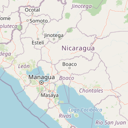
Map view of Zapatera Archipelago National Park

Use this park location map to pinpoint Zapatera Archipelago National Park in Nicaragua, understand its exact geographic position, and read its mapped placement within the surrounding landscape more clearly.

Pigeon | © OpenStreetMap contributors
Park atlas

Compare surrounding protected areas, tracing the regional spread of island ecosystems and Central American landscapes.

Discover Other National Parks Near Zapatera Archipelago National Park and Lake Nicaragua

After exploring Zapatera Archipelago National Park, continue your discovery by browsing nearby protected areas and similar island ecosystems across Central America. Compare their unique volcanic landscapes, lacustrine environments, and conservation profiles to understand the regional geography of protected lands.
Nature reserveNicaragua
About 24 km away#1 closest

Northwest

Laguna de Apoyo Nature Reserve: Geographic Profile and Protected Volcanic Caldera

A study of volcanic lake hydrology and tropical dry forest terrain.

Laguna de Apoyo Nature Reserve is a prominent protected landscape in Nicaragua, centered on a deep crater lake of volcanic origin. This nature reserve protects a circular caldera filled by an endorheic lake, ringed by diverse tropical dry forest. The area serves as a significant site for understanding geological landforms and the specialized freshwater biodiversity found within its sheltered basin.

Area
35 km²
Established
1991
IUCN
IV
Relief
Mixed relief
National parkNicaragua
About 45 km away#2 closest

Northwest

Masaya Volcano National Park: Nicaragua National Park Atlas & Landscape Context

Explore the mapped boundaries of this unique volcanic terrain.

Masaya Volcano National Park offers a distinct focus for atlas exploration within Nicaragua's broader geographic framework. This page details the park's identity as a protected landscape, highlighting its volcanic terrain and mapped features. Understand its significance within the national park system and its contribution to the mapped natural heritage of Central America.

IUCN
II
Relief
Mountain
Access
Access unknown
Nature reserveManagua Department
About 50 km away#3 closest

Northwest

Chocoyero-El Brujo Natural Reserve: Geographic Overview and Protected Landscape Mapping

Tropical ravine forest and critical watershed in Managua Department.

This nature reserve protects a vital intersection of tropical forest and steep ravine terrain. Centered on the iconic El Brujo and Chocoyero waterfalls, the area acts as a crucial watershed and nesting ground for green parakeet colonies. The compact, vertical landscape provides a unique look at how small protected areas maintain biodiversity and regional water security near the capital of Nicaragua.

Area
1.8 km²
Established
1993
Visitors
10K annual
Relief
Upland
National parkGuanacaste Province
About 77 km away#4 closest

South

Santa Rosa National Park: Guanacaste Province National Park Protected Area

Mapped natural landscape and regional geography.

Santa Rosa National Park is a vital protected area within Costa Rica's Guanacaste Province. This detail page offers an atlas-focused view of the park, highlighting its geographic setting and mapped boundaries. It serves as a primary resource for understanding the park's protected landscape identity and its contribution to regional conservation geography, supporting structured exploration for users interested in natural areas.

Area
815.31 km²
Established
1966
IUCN
II
Climate
Tropical
National parkGuanacaste Province
About 80 km away#5 closest

South

Guanacaste National Park: A Protected Landscape within Guanacaste Province's Geography

Explore mapped park boundaries and regional natural landscape context.

Delve into the protected landscape of Guanacaste National Park, a significant national park located within Guanacaste Province. This entry provides a focused view of its geographic features, mapped protected areas, and its role within the regional terrain. Understand the park's specific natural landscape character and its placement in the broader atlas of conservation lands.

Area
340 km²
Established
1991
IUCN
II
Relief
Mixed relief
National parkGuanacaste Province
About 118 km away#6 closest

Southeast

Rincón de la Vieja National Park: Costa Rican National Park Atlas Entry

Mapped protected landscape and regional geography.

Gain a structured understanding of Rincón de la Vieja National Park as a key protected area within Guanacaste Province. This detail page offers an atlas-focused perspective, highlighting its mapped boundaries and regional geographic significance. Explore how this national park contributes to the protected landscapes of Costa Rica, providing essential context for geographic discovery.

Area
141.61 km²
Established
1973
IUCN
II
Climate
Tropical
National parkCosta Rica
About 129 km away#7 closest

Southeast

Miravalles Jorge Manuel Dengo National Park: Costa Rica National Park Geographic Context

Mapped protected landscape and regional park geography.

Miravalles Jorge Manuel Dengo National Park offers a focused lens for understanding protected natural areas within Costa Rica. Explore its specific geographic footprint and the surrounding regional context to appreciate its significance as a mapped protected landscape. This detailed view supports a structured discovery of the park's identity, helping users grasp its place within the national atlas.

Area
43 km²
Established
2019
IUCN
II
Relief
Mountain
Nature reserveNicaragua
About 133 km away#8 closest

North

Cerro Pancasan Natural Reserve: Geographic Overview of a Nicaraguan Protected Forest Hill

Exploring mountain-slope terrain and regional watershed conservation

As a significant hill reserve in western Nicaragua, Cerro Pancasan Natural Reserve protects essential tropical forest cover against agricultural encroachment. This entry provides a detailed look at the reserve's topography, its role in maintaining regional stream flow, and its place within the country-wide SINAP network of protected land.

Scope
Terrestrial

Common questions about visiting, size, designation, and location context for Zapatera Archipelago National Park

Zapatera Archipelago National Park FAQs for park facts, access, geography, and protected area context

Find quick answers about Zapatera Archipelago National Park, including protected-area facts, park geography, trail and visitor context, and how the park fits into its surrounding country and regional landscape.
MoriAtlas Explorer

Continue Your Protected Areas Search Across the Global Atlas

Deepen your exploration by continuing the structured search for national parks and protected areas worldwide. Utilize the comprehensive filtering capabilities to compare different conservation landscapes and refine your understanding of global park geography. Discover more about the distribution and characteristics of protected natural areas.

Global natural geography
