


Mori Atlas logo
Nature reserveAbberton Reservoir

Examining the mapped boundaries, layered reservoir terrain, and regional habitat context

Abberton Reservoir: A Comprehensive Geographic Atlas of a Major Essex Protected Wetland

Abberton Reservoir serves as a significant freshwater landscape and protected wetland site located in Essex, England. This data-driven entry explores its geometric structure, including the main reservoir body and surrounding marginal habitats created through extensive shoreline restoration. Gain insights into the site's role as a primary waterbird sanctuary, its unique wartime heritage, and its position within the gently undulating claylands of the East of England.

freshwater reservoirRamsar wetlandSite of Special Scientific InterestSpecial Protection Areawintering wildfowlwaterbird sanctuary
A flat-style digital illustration of a large reservoir surrounded by green hills, forests, and steep cliff edges with a small boat on the water.

Abberton Reservoir

Nature reserve

Park overview

Structured park overview, official facts, and landscape profile for Abberton Reservoir

Abberton Reservoir park facts, protected area profile, and essential visitor context

Review the core facts for Abberton Reservoir, including designation, size, terrain, visitor scale, habitats, and operating context in one park-focused overview.

About Abberton Reservoir

Abberton Reservoir is a large pumped storage reservoir in eastern England, set in the dry landscape of Essex within a few kilometres of both Colchester and the North Sea coast. With a surface on the order of 700 hectares it is the biggest freshwater body in the county, supplied mainly by water pumped from the River Stour to the north-east and, since 2013, supplemented from the River Great Ouse in Norfolk. Its primary role is to provide drinking water for around 750,000 people across Essex and north-east London, but it is equally valued as one of the most important wetlands in Britain for waterbirds.

Created between 1935 and 1939 by damming the Layer Brook, the reservoir was one of a series of grand water-supply schemes that reshaped the driest parts of England during the early twentieth century. A lengthy London Clay core anchors the dam wall, and topsoil stripped from the basin was used to shape its edges. The reservoir has been progressively improved for wildlife, most dramatically between 2010 and 2013, when about 12 kilometres of the original concrete apron and perimeter road were broken up, the banks were reprofiled for waterbirds, and around 200 hectares of adjacent land were brought into active nature management.

Conservation has become inseparable from the reservoir's identity. It is a Ramsar wetland internationally important for wintering wildfowl, a national Site of Special Scientific Interest, and a Special Protection Area under the European Union Birds Directive. The site appears in the classic two-volume A Nature Conservation Review, which catalogued Britain's most important wildlife sites. Today the layered partnerships between Essex and Suffolk Water, the Essex Wildlife Trust and visiting researchers underpin an active programme of bird ringing, habitat management and recreational access that has run for decades.

Visitors encounter a working reservoir that doubles as a major wildlife attraction. The Essex Wildlife Trust runs the Abberton Reservoir Nature Discovery Park on the Layer de la Haye causeway, with a visitor centre, café, shop and bird hides, while public footpaths and viewing screens give access to the wider waterbody and its margins.

Quick facts and research context for Abberton Reservoir

Abberton Reservoir sits in Essex just south-west of Colchester and within easy reach of the Essex coast. It is the largest freshwater body in the county and is operated as a pumped storage reservoir supplying water to Essex and north-east London.

The site is managed by Essex and Suffolk Water, part of the Northumbrian Water Group, and is supported by the Essex Wildlife Trust, which runs the Abberton Reservoir Nature Discovery Park and visitor facilities at the north end of the Layer de la Haye causeway. A major expansion completed in 2013 lifted capacity to around 41,000 megalitres, reprofiled banks for wildlife, and added a transfer link from the River Great Ouse in Norfolk via the River Stour.

Protection and recognition

Documented terrestrial protection history and official Ramsar and Natura 2000 listings

Abberton Reservoir Protection Status and International Recognition Data

Abberton Reservoir features documented terrestrial protection status established in 1981 alongside official international designations including Ramsar and Natura 2000 listings. Structured records outline the official recognition history and conservation framework associated with the protected area.

International recognition

Protection details

Protection scope
Terrestrial
Designated year
1981
Transboundary protection
No
Park context

Deeper park guide and search-rich context for Abberton Reservoir

Abberton Reservoir history, landscape, wildlife, and travel context

Explore Abberton Reservoir through its history, landscape character, ecosystems, wildlife, conservation priorities, cultural context, and seasonal travel timing in a structured park guide built for atlas discovery and search intent.

Why Abberton Reservoir stands out

Abberton Reservoir is best known as one of the most important inland waterbird sites in Britain, regularly holding around 35,000 wintering wildfowl and more in severe weather. It is of international importance for wintering gadwalls, shovelers and Eurasian wigeons, and was the first inland tree-nesting colony of great cormorants in England. The reservoir is also closely associated with the famous Dam Busters raid of 1943. RAF No. 617 Squadron used Abberton as a low-level practice site for the bouncing bomb attacks that destroyed the Möhne and Eder dams in the Ruhr.
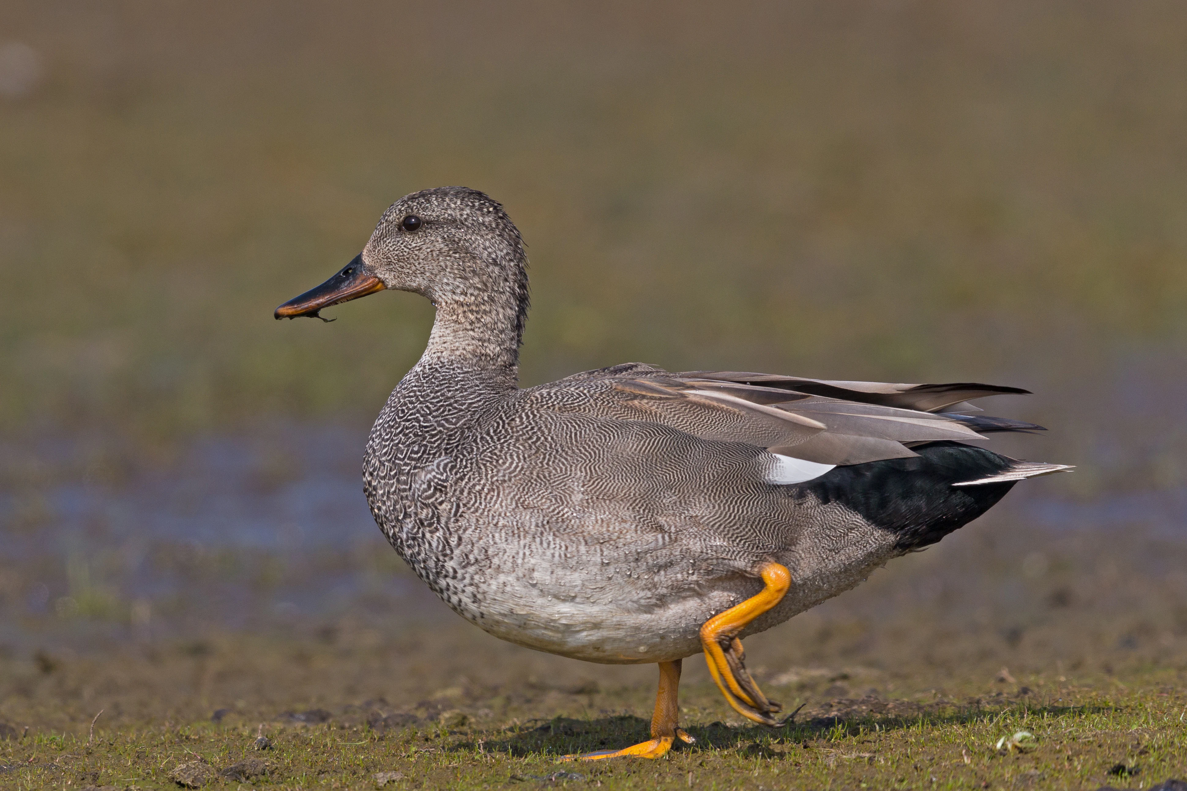
A medium-sized grey duck, the Gadwall, stands on a brown muddy bank with its head facing left and one leg slightly lifted.
A Gadwall, Anas strepera, stands on the muddy shore of Abberton Reservoir.

Abberton Reservoir history and protected-area timeline

The story of Abberton Reservoir begins with Essex's chronic water shortage. As one of the driest counties in England, Essex relied heavily on the chalk aquifer beneath it. The South Essex Waterworks Company, founded in 1861, drilled ever-deeper wells and boreholes to supply towns from East Ham to Brentwood, but by the First World War that supply was no longer keeping up with demand. The South Essex Waterworks Act 1928 authorised a reservoir scheme, and a follow-up act in 1935 approved the pipelines, pumping stations and treatment works needed to make it real.

Construction took place between 1935 and 1939 on what had been farmland with a couple of small woods. Engineers dammed the Layer Brook and built a 690-metre dam wall using the underlying London Clay as an impermeable puddle clay core, sandwiched between layers of soil and gravel. Topsoil stripped from the basin was reused to shape the reservoir's edges, and a concrete apron was laid along most of the 17.7-kilometre perimeter. The reservoir originally held around 25,000 megalitres when it was first filled in 1939.

Almost immediately, the reservoir became a wartime site. The Ministry of Defence feared it could be used by German seaplanes in a possible invasion, and 312 naval mines were anchored in a grid across the water, with steel cables strung near the pumping station to protect it. When war began, the RAF's No. 617 Squadron used Abberton as a practice site for the bouncing bomb attacks later carried out against the Möhne and Edersee dams in the Ruhr in May 1943. Avro Lancaster bombers flew repeated low-level runs over the reservoir, and the final rehearsal took place on the night of 14 May 1943, two nights before the real raid. A blue plaque installed in 2025 now commemorates the reservoir's role in the Dam Busters story.

In the post-war decades, growing demand led to a major expansion. Beginning around 2007, Essex and Suffolk Water, part of the Northumbrian Water Group, undertook a £140 million scheme completed in 2013 that raised the banks and increased capacity to about 41,000 megalitres, while replacing the original Stour pipeline with a higher-capacity route taking water from Wormingford. A second key element was a transfer system bringing water from the River Great Ouse in Norfolk via a new 15.5-kilometre tunnel to Wixoe and on through the Stour, allowing the reservoir to draw on water 141 kilometres away in dry years.

Abberton Reservoir landscape and geographic character

Abberton Reservoir lies on the gently undulating claylands of north-east Essex, only a short distance inland from the coastal flats of the Blackwater and Colne estuaries. The dam wall blocks the small Layer Brook, creating a broad, shallow artificial lake divided into three sections by the Layer Breton and Layer de la Haye causeways. The eastern Main section is the largest and deepest, while the Central and Western sections are smaller and separated from the main body by road causeways.

Originally the Main section was ringed by a concrete apron and perimeter road that gave the reservoir an engineered, geometric shoreline. The 2010 to 2013 expansion deliberately broke up about 12 kilometres of that apron, reprofiling the edges into irregular muddy margins that grade gently into reeds, wet grassland and damp cultivated fields. Bordering habitats around the smaller Western section retain natural reedbeds and willow stands, giving the wider site a layered character of open water, marsh, damp meadow and farmland rather than a single uniform shoreline.

The surrounding landscape is a mix of arable fields, hedgerows and small woods, with the nearby villages of Abberton, Layer de la Haye and Layer Breton framing the view. From the causeways and public footpaths, the water opens out across a wide, quiet horizon backed by gentle rises and, on clear days, hints of the East Anglian skyline to the north.
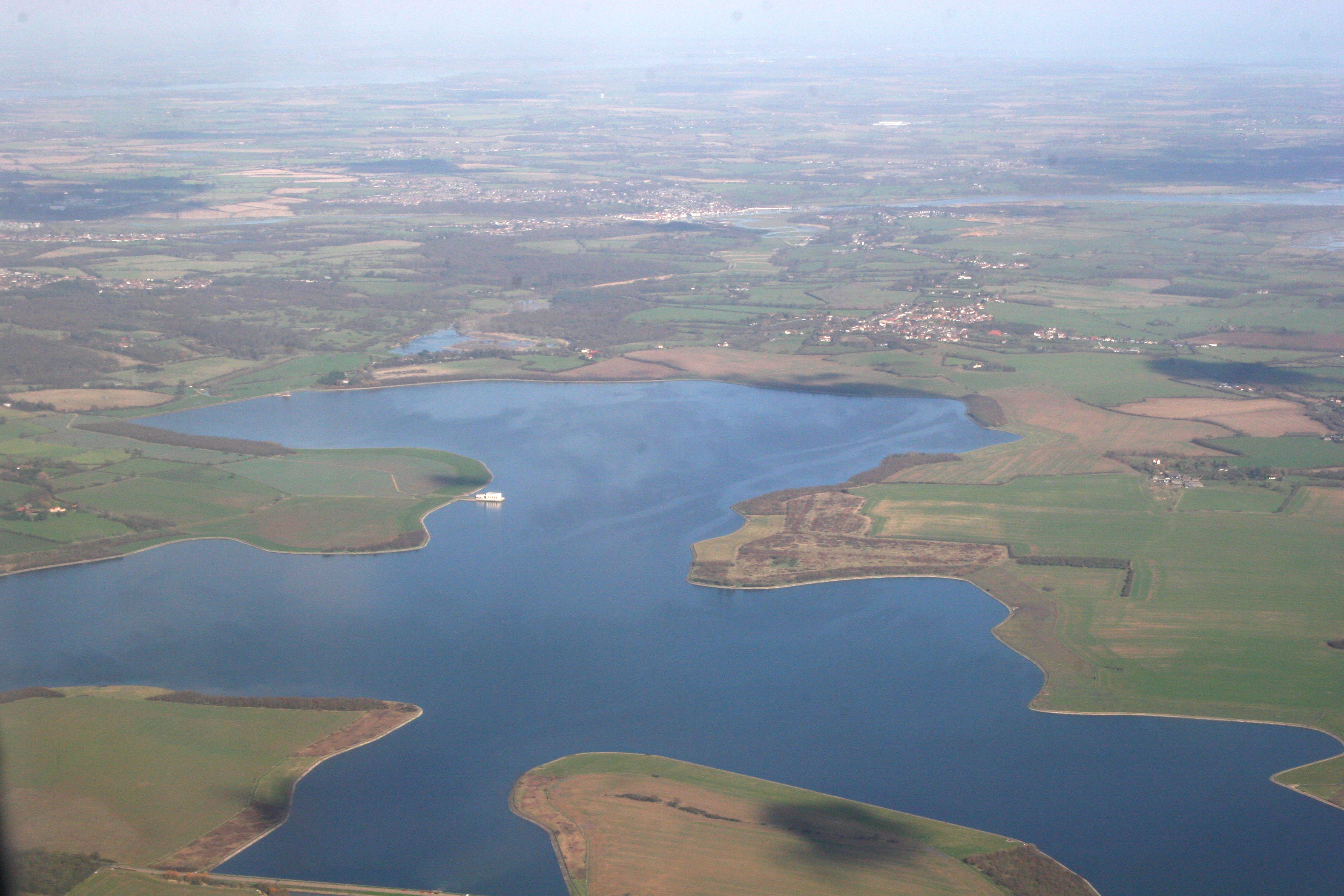
An aerial view of the Abberton Reservoir showing the expansive blue body of water surrounded by green and brown agricultural fields.
Aerial view of Abberton Reservoir and the surrounding Essex landscape.

Abberton Reservoir ecosystems, habitats, and plant life

Ecologically, Abberton is best understood as a freshwater wetland complex set within an intensely farmed coastal county. The three reservoir sections support subtly different habitats: the smaller Western and Central basins are fringed by common reed and willow that give way to damp grassland and cultivated fields, while the larger Main section combines open water with newly created muddy margins and pools.

The 2013 expansion deliberately turned much of the former concrete edge into a mosaic of pools, scrapes and marshland, particularly west of the Layer de la Haye causeway. A blocked culvert allows the Western section's water levels to be managed independently, creating attractive conditions for breeding waders and wildfowl. Across the wider reserve, damp grassland, scrub margins and small woods add terrestrial habitats so that species can move between water, bank and field without crossing intensively managed land.

Although Abberton is a man-made reservoir, it now functions ecologically like a rich coastal freshwater lake. Inland from saltmarshes and tidal mudflats, it offers large open water in a dry region, drawing enormous flocks of ducks, geese and waders as well as breeding herons, egrets and reedbed warblers. Long-running bird ringing has built up detailed knowledge of population dynamics, and recoveries of ringed ducks have set national longevity records for ten species, including wigeon and gadwall.

Abberton Reservoir wildlife and species highlights

Abberton's birdlife is what most visitors come for. The reservoir is internationally important for wintering gadwalls, northern shovelers and Eurasian wigeons, and nationally important for mute swans, Eurasian teal, common pochards, tufted ducks, goldeneyes, coots and great crested grebes. In severe winters it can hold well over 40,000 individual wildfowl, the highest count for any inland water body in the United Kingdom, and many ducks also moult on the water during their stay.

Breeding birds are equally distinctive. Abberton became the first inland tree-nesting colony of great cormorants in England in 1981, by 1993 held 584 pairs, and now supports around 180 breeding pairs as well as little egrets and, since 2020, cattle egrets. Around 20 pairs each of Cetti's warblers and common nightingales breed on site, while typical farmland species such as corn buntings, yellowhammers and western barn owls nest in the protected margins. Up to eight pairs of little ringed plovers use the reprofiled muddy shorelines in summer, and winter brings regular bitterns in the Western section and hunting hen harriers, merlins, peregrine falcons and western marsh harriers over the bordering grassland.

Rarities add to the site's pull, reflecting its proximity to the coast. Highlights include Britain's first canvasback (1997 to 2001), a lesser scaup (2004 to 2005), a blue-winged teal (1996), regular smews and long-tailed ducks, and occasional red-footed falcons, Caspian, whiskered and white-winged black terns, Bonaparte's gulls, Franklin's gull and ortolan buntings. Beyond birds, otters patrol the edges, water voles and brown hares occupy the damp grassland, eight bat species have been recorded, and amphibians include the great crested newt. Two rare weevils, Rhynchites auratus and the fungus specialist Anthribus fasciatus, are also present, although American signal crayfish have become an invasive concern.

Abberton Reservoir conservation status and protection priorities

Abberton Reservoir is one of the most heavily designated freshwater sites in eastern England. It was first recognised internationally when it became a Ramsar wetland in 1981, followed by confirmation as a Site of Special Scientific Interest in 1988. In 1991 it was classified as a Special Protection Area under the European Union Birds Directive, explicitly because of its overwintering golden plovers, gadwalls, shovelers and teals, and its breeding cormorants, with substantial numbers of black-tailed godwits, lapwings, coots, goldeneyes, tufted ducks, pochards, pintails, wigeons and great crested grebes also cited.

The site also features in the classic A Nature Conservation Review, the landmark 1970s survey that catalogued Britain's most important wildlife areas. Today its protection rests on a layered partnership: Essex and Suffolk Water owns and manages the working reservoir, the Essex Wildlife Trust runs the Abberton Reservoir Nature Discovery Park at the Layer de la Haye causeway, and statutory designations protect the water itself and the surrounding land brought into conservation management during the 2013 expansion.

Conservation work has reshaped the physical reservoir itself. The breaking up of 12 kilometres of concrete apron and the reprofiling of banks created new muddy margins, pools and marshland that benefit breeding waders and wintering ducks. Concerns remain about non-native signal crayfish, which can displace native white-clawed crayfish and burrow into the banks of the Layer Brook, increasing sediment input into the reservoir.

Abberton Reservoir cultural meaning and human context

Abberton Reservoir sits in a quiet corner of rural Essex defined by small villages, medieval churches and centuries of agricultural land use. The villages of Abberton, Layer de la Haye and Layer Breton still anchor the landscape around the water, and St Andrew's Church in Abberton remains a familiar landmark visible from parts of the reservoir. The site's history as former farmland is preserved in the name of Layer Breton Causeway and in the patchwork of damp meadows and small woods that ring the water.

The reservoir's most resonant cultural association is with the Dam Busters raid of May 1943. RAF No. 617 Squadron used Abberton as a low-level practice site for the bouncing bomb attacks on the Möhne and Edersee dams in the Ruhr, and the final full-dress rehearsal took place on the night of 14 May 1943. A blue plaque installed at the reservoir in 2025 now commemorates that wartime chapter, ensuring the Dam Busters story remains visible to modern visitors who come mainly for the wildlife.

Top sights and standout views in Abberton Reservoir

Abberton combines a vital water-supply role with three layers of conservation designation and a striking wartime heritage. Its location, only a short distance from the Essex coast, helps explain why it can support such huge wintering flocks of wildfowl, while its 2013 redesign turned a working concrete-edged reservoir into a mosaic of open water, marsh and damp grassland that benefits waders, breeding birds and amphibians alike.

Best time to visit Abberton Reservoir

Most visitors come to Abberton for its birdlife, and winter is by far the most rewarding season. From November through February the reservoir can hold tens of thousands of wildfowl, including internationally important numbers of gadwalls, shovelers and wigeons, and cold weather often pushes totals well above 40,000 birds, with regular bitterns in the Western section and raptors hunting the surrounding fields.

Spring and early summer bring a different character, with breeding cormorants at the first inland tree-nesting colony of its kind in England, displaying great crested grebes on the open water, and little ringed plovers on the recently reprofiled muddy margins. Late spring can also produce scarce migrants such as terns and red-footed falcons, making May a particularly exciting month for experienced birders. Autumn sees returning waterfowl gathering again and the chance of unusual visitors dropped in from the nearby coast.
Monthly climate preview

Long-term representative point measurements tracking monthly temperature and precipitation rhythms in Essex

Abberton Reservoir Climate Normals, Annual Temperature and Precipitation Profiles

Historical climate normals for Abberton Reservoir record measured monthly temperature ranges alongside consistent daily precipitation averages. Detailed twelve-month datasets expand these baseline patterns into a complete comparative profile for the protected area.
Annual mean10 °C
4 °C17 °C
Jan
Feb
Mar
Apr
May12°
Jun15°
Jul17°
Aug17°
Sep15°
Oct11°
Nov
Dec
Warmest month
July

17.3 °C

Coolest month
January

4.1 °C

Wettest month
November

2.3 mm/day

Driest month
March

1.5 mm/day

Park location guide

Geography guide, regional context, and park location map for Abberton Reservoir

Abberton Reservoir park geography, regions, and map view in United Kingdom

Understand where Abberton Reservoir sits in United Kingdom through a broader geographic reading of the surrounding landscape, nearby location context, and its mapped position within the national park landscape.

How Abberton Reservoir fits into United Kingdom

The United Kingdom is a parliamentary constitutional monarchy located in northwestern Europe, consisting of four constituent countries: England, Scotland, Wales, and Northern Ireland. As a major global power with over 69 million residents, it maintains significant international influence in politics, economics, and culture.

Wider geography shaping Abberton Reservoir in United Kingdom

The United Kingdom is an island nation located in northwestern Europe, surrounded by the Atlantic Ocean, North Sea, English Channel, Celtic Sea, and Irish Sea. It shares a land border with the Republic of Ireland to the west. The territory includes the island of Great Britain, the northeastern portion of Ireland, and most of the smaller British Isles islands.

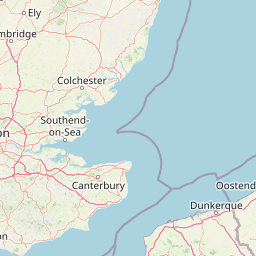
Map view of Abberton Reservoir

Use this park location map to pinpoint Abberton Reservoir in United Kingdom, understand its exact geographic position, and read its mapped placement within the surrounding landscape more clearly.

Pigeon | © OpenStreetMap contributors

Location context for Abberton Reservoir

Essex

Visual reference of waterbird habitats, shorelines, and wetland terrain

Abberton Reservoir Photos, Scenery, and Protected Landscape Views

Visual documentation reveals the engineered shorelines, expansive open water, and surrounding wetland habitats of Abberton Reservoir. Examining these protected landscapes provides clear insight into the terrain, waterfowl sanctuaries, and characteristic Essex scenery.

A medium-sized grey duck, the Gadwall, stands on a brown muddy bank with its head facing left and one leg slightly lifted.

A single-story building with dark siding and a grey tiled roof serving as a visitor centre, featuring a gable entrance with a visible Essex Wildlife Trust sign.

An aerial view of the Abberton Reservoir showing the expansive blue body of water surrounded by green and brown agricultural fields.

Park atlas

Compare regional wetland reserves and surrounding conservation areas across Essex

Parks Near Abberton Reservoir and Related Protected Landscapes in Eastern England

Browsing other parks near Abberton Reservoir reveals connected wetland habitats and regional protected landscapes across the surrounding countryside. Continuing through these comparable sites provides broader geographic context for the freshwater reserves of eastern England.
Nature reserveEssex
1.8 km away#1 closest

East

Colne Estuary Nature Reserve: Geography and Protected Landscapes of the Essex Coast

Coastal wetlands, saltmarsh zones, and geological formations

Colne Estuary represents a massive tidal landscape in Essex characterized by the interaction between fluvial and marine systems. Covering over 2,900 hectares, this site protects diverse habitats including intertidal mudflats, active saltmarshes, and transitional zones that support wintering waterbirds. The area remains a key reference for studying coastal accretion and Quaternary geology in the East of England.

Area
29.152 km²
Established
1989
Relief
Lowland
Climate
Temperate
Marine protected areaEssex
About 13 km away#2 closest

Southeast

Blackwater, Crouch, Roach and Colne Estuaries Marine Conservation Zone Geography and Map

A comprehensive look at England's largest inshore marine protected area.

Covering 284 square kilometers of the Essex coast, this marine conservation zone integrates four tidal estuaries and North Sea coastal frontage into a single protected system. Recognized for its unique native oyster beds and vast intertidal mudflats, the area provides essential habitat for waterfowl. Explore the mapped terrain and overlapping conservation boundaries that define this vital estuarine landscape.

Area
284 km²
Relief
Lowland
Climate
Temperate
Scope
Marine
Nature reserveSuffolk
About 38 km away#3 closest

Northeast

Martlesham Wilds Nature Reserve: Suffolk Wetland and Protected Landscape Geography

Examining the ecological corridor along the River Deben estuary

Martlesham Wilds represents a significant lowland rewilding effort in eastern England. The 117 hectare reserve, managed by the Suffolk Wildlife Trust, creates a vital connection between ancient woodlands, tidal marshes, and freshwater wetland scrapes. Explore the geographic layout and protected boundaries of this developing sanctuary on the Deben Estuary.

Area
1.17 km²
Established
2023
Relief
Lowland
Climate
Temperate
Watercolor painting showing grassy wetlands and distant hills with a sunset sky
National parkUnited Kingdom
77 km away#4 closest

Northeast

The Broads National Park: Wetland Landscape, Rivers, and Regional Geography Atlas

Explore mapped waterways and protected reedbed ecosystems.

The Broads National Park offers a singular protected wetland landscape with over 200 kilometers of navigable waterways across its numerous shallow lakes, or 'broads.' Shaped by medieval peat excavations and natural processes, this area presents a unique geography of reedbeds and grazing marshes, punctuated by historic windmills. Discover the mapped extent of this protected landscape, its river systems, and its vital role in regional geography through structured atlas data.

Area
303 km²
Established
1989
IUCN
V
Relief
Lowland
Nature reserveSurrey
About 100 km away#5 closest

West

Wraysbury Reservoir: An Engineered Nature Reserve and Vital Wetland Habitat in Surrey

Examining infrastructure, ecology, and sonar testing geography.

Wraysbury Reservoir stands as a unique example of late-twentieth-century industrial landscape design, serving as both a primary London water resource and a protected Ramsar wetland. Its earthen embankments enclose a specialized environment where sonar research and ecological conservation coexist within the wider context of the Thames Valley. This record details the site's boundaries, its function as a wintering bird refuge, and its specialized role in UK marine testing.

Area
2.05 km²
Established
1970
Relief
Lowland
Climate
Temperate
Watercolor illustration of a coastal landscape featuring green hills, white cliffs, and a body of water
National parkSouth East England
115 km away#6 closest

Southwest

South Downs National Park: A Distinctive Chalk Landscape in South East England's Atlas

Iconic chalk downland, coastal cliffs, and mapped terrain.

South Downs National Park is a premier protected landscape in South East England, celebrated for its unique chalk downland terrain and dramatic coastal formations. This page provides detailed geographic context for the park, highlighting its rolling hills, dry valleys, and ancient woodlands. Discover the park's mapped boundaries and its significance within England's protected areas, offering a structured atlas view for landscape exploration.

Area
1,627 km²
Established
2010
IUCN
V
Visitors
18M annual
Nature reserveNorthamptonshire
About 115 km away#7 closest

Northwest

Summer Leys Nature Reserve: Geographic Context and Mapped Wetland Boundaries in Northamptonshire

Wetland ecosystems and industrial land reclamation in the Upper Nene Valley

Summer Leys is an important nature reserve and protected wetland complex in Northamptonshire. Defined by its history as a gravel extraction site, the landscape now features open lagoons, reed-fringed pools, and vital grassland habitats. This site provides a critical study in how former industrial terrain is repurposed for ecological conservation and avian biodiversity within the regional landscape of the English East Midlands.

Area
0.5 km²
Relief
Lowland
Climate
Temperate
Access
Easy access
A horizontal watercolor painting showing a soft landscape with green vegetation, pink accents, and a winding body of water leading towards distant hills.
Nature reserveFrance
About 120 km away#8 closest

Southeast

Réserve naturelle régionale du mont de Couple: Protected Chalk Escarpment and Coastal Viewpoint

A limestone ridge sanctuary in the northern French Boulonnais region

Spanning a rare chalk cuesta in northern France, this protected area balances ecological conservation with distinct geological features. The reserve provides critical habitat for orchids and protected flora while serving as a strategic viewpoint across the Straits of Dover and the surrounding Opal Coast terrain.

Area
0.136 km²
Established
1997
Relief
Upland
Climate
Temperate

Common questions about visiting, size, designation, and location context for Abberton Reservoir

Abberton Reservoir FAQs for park facts, access, geography, and protected area context

Find quick answers about Abberton Reservoir, including protected-area facts, park geography, trail and visitor context, and how the park fits into its surrounding country and regional landscape.
MoriAtlas Explorer

Continue Your Protected Areas Search Across the Global Atlas

Deepen your exploration by continuing the structured search for national parks and protected areas worldwide. Utilize the comprehensive filtering capabilities to compare different conservation landscapes and refine your understanding of global park geography. Discover more about the distribution and characteristics of protected natural areas.

Global natural geography



