Mori Atlas logo
Protected areaAilinginae Atoll

Analyzing the low-lying coral landscape, lagoon boundaries, and regional Ralik Chain context

Ailinginae Atoll Protected Area: Mapping the Geography of a Remote Marshall Islands Coral Atoll

Ailinginae Atoll represents a distinct protected coral landscape at the northern edge of the Ralik Chain within the Marshall Islands. This uninhabited atoll consists of a narrow ring of islets encircling a large interior lagoon, with a significant disproportion between its emerged land mass and enclosed water surface. The geography is defined by its extreme flatness, with natural elevations rarely exceeding three meters, and its long-standing status as a preserved environmental zone within the broader Pacific reef network.

coral atolluninhabited islandRalik ChainMarshall Islandsnuclear testing historyCastle Bravo legacy

Ailinginae Atoll

Protected area

Park overview

Structured park overview, official facts, and landscape profile for Ailinginae Atoll

Ailinginae Atoll park facts, protected area profile, and essential visitor context

Review the core facts for Ailinginae Atoll, including designation, size, terrain, visitor scale, habitats, and operating context in one park-focused overview.

About Ailinginae Atoll

Ailinginae Atoll is a small, low coral atoll in the central-western Pacific Ocean, part of the Marshall Islands and more specifically the northernmost member of the Ralik Chain. From above, it appears as a thin ring of tiny islets and reef enclosing a broad blue lagoon, a morphology typical of Oceanic atolls formed on subsided volcanic foundations. The atoll's dry land is dominated by scrub, grasses, and scattered stands of Pisonia grandis trees that together support a modest tropical flora of around 29 recorded plant species.

Although physically small and ecologically modest, Ailinginae carries an outsized historical significance. It was one of several Marshallese atolls whose residents were displaced in 1954 following the Castle Bravo thermonuclear test at Bikini Atoll, and it has remained uninhabited ever since. The resulting absence of permanent settlement distinguishes it from most other Marshallese atolls and makes it a quiet, essentially unoccupied island system within the wider Marshall Islands reef network.

Traversing the atoll is shaped almost entirely by the sea. The two passages into the lagoon, Mogiri Pass and Eniibukku Pass, are the principal gateways between the open ocean and the interior waters of the atoll; they are relatively narrow, and the surrounding reef structure remains a defining feature of the island's geography. Together with adjacent atolls such as Rongelap, Utirik, and Bikini, Ailinginae sits at the heart of one of the most internationally recognized Pacific regions, where questions of nuclear testing, environmental remediation, climate-driven sea-level rise, and indigenous Marshallese identity intersect on remote and fragile coral landscapes.

Quick facts and research context for Ailinginae Atoll

Ailinginae Atoll lies in the northwestern Ralik Chain of the Marshall Islands, west of Rongelap Atoll and south of Bikini Atoll. It is a classic low coral atoll of 25 islets ringing a roughly 106 square kilometer lagoon, with total dry land area of only about 2.8 square kilometers and a maximum elevation of approximately 3 meters.

The atoll is politically part of the Republic of the Marshall Islands but has had no permanent population since 1954, when residents were evacuated in response to radioactive fallout from the U.S. Castle Bravo test at neighboring Bikini Atoll. Its two lagoon passages, Mogiri Pass and Eniibukku Pass, serve as the principal natural connections between the open Pacific and the interior lagoon.

Park context

Deeper park guide and search-rich context for Ailinginae Atoll

Ailinginae Atoll history, landscape, wildlife, and travel context

Explore Ailinginae Atoll through its history, landscape character, ecosystems, wildlife, conservation priorities, cultural context, and seasonal travel timing in a structured park guide built for atlas discovery and search intent.

Why Ailinginae Atoll stands out

Ailinginae is most widely recognized as an uninhabited Pacific atoll whose former population was evacuated in 1954 due to fallout from the Castle Bravo nuclear test at Bikini Atoll. This nuclear history gives the atoll a distinctive identity even among the many remote Marshallese reefs. Beyond that legacy, the atoll is also known for the pronounced contrast between its tiny emerged land area and its very large enclosed lagoon, and for its position at the northern tip of the Ralik Chain, close to Rongelap, Bikini, and Utirik. That neighborhood places Ailinginae firmly within the arc of Marshall Islands most affected by 20th-century geopolitical and nuclear history.
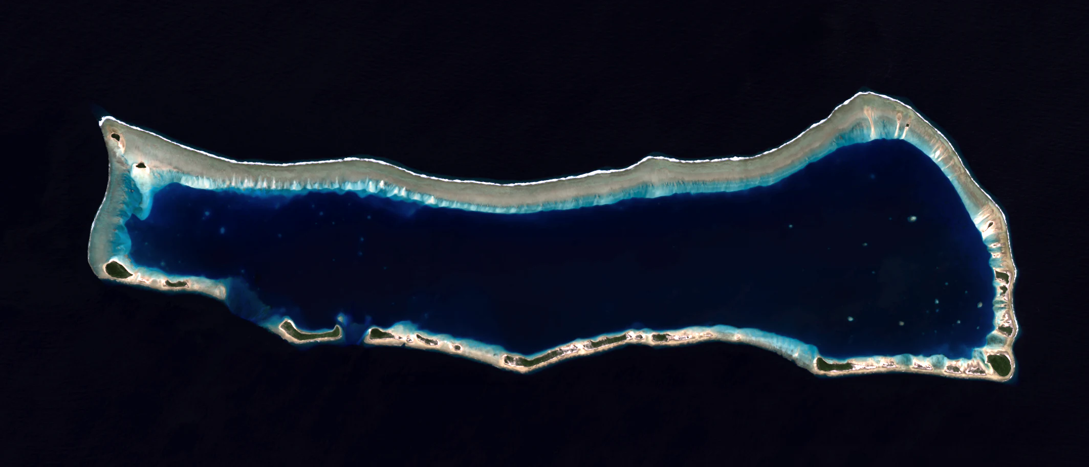
Top-down satellite view of Ailinginae Atoll, a coral ring structure surrounding a dark blue lagoon, set against a black background.
A satellite view of Ailinginae Atoll in the Marshall Islands, showing its elongated shape and central lagoon.

Ailinginae Atoll history and protected-area timeline

The recorded European history of Ailinginae Atoll begins on 1 January 1528, when the Spanish navigator Álvaro de Saavedra made the first known Western sighting of the atoll during his Pacific crossing. Together with Utirik Atoll and Rongelap Atoll, Ailinginae was later charted collectively as the 'Islas de los Reyes', or Islands of the Three Wise Kings, in reference to the proximity of the sighting to the Christian feast of Epiphany.

During the late colonial period, Ailinginae was claimed by the German Empire as part of its broader assertion over the Marshall Islands in 1885. After the First World War, control of the islands passed to the Empire of Japan under the League of Nations South Seas Mandate. Following the Second World War, Ailinginae came under United States administration as part of the Trust Territory of the Pacific Islands, a status it held until the Republic of the Marshall Islands became independent in 1986.

The most consequential event in Ailinginae's modern history was the 1954 Castle Bravo thermonuclear test, conducted at Bikini Atoll to the northwest. In the aftermath, fear of radioactive contamination led to the evacuation of the atoll's small Marshallese population, and Ailinginae has remained uninhabited since that displacement. This history places the atoll firmly within the wider story of U.S. nuclear testing in the Marshall Islands and the long-term displacement of Marshallese communities from their home atolls.

Ailinginae Atoll landscape and geographic character

Ailinginae's landscape is the textbook form of a low Oceanic coral atoll, with a scattering of small islets and reef segments rising barely above sea level and encircling a large interior lagoon. The total emerged area is only about 2.8 square kilometers, but this thin land rim encloses a lagoon of roughly 106 square kilometers, producing a striking disproportion between land and enclosed water.

The highest natural point on the atoll sits at only about 3 meters above sea level, leaving the entire landscape exposed to the ocean that surrounds it. The ocean-facing side of the ring is shaped by reef and surf, while the lagoon side offers calmer, sheltered waters. Two relatively narrow passages, Mogiri Pass and the smaller Eniibukku Pass, connect the lagoon with the open Pacific and effectively define the practical entry points into the atoll for any vessel approaching from outside.

Ailinginae Atoll ecosystems, habitats, and plant life

Ecologically, Ailinginae is a small and relatively simple atoll ecosystem, shaped by coral, sand, salt spray, and the limited fresh water available on such low islands. Vegetation on the islets is dominated by scrub, low grasses, and scattered groves of Pisonia grandis, a tropical tree commonly associated with seabird nesting habitats across Pacific atolls. The recorded flora of roughly 29 plant species reflects both the restricted habitat area and the influence of salt, wind, and periodic drought.

As an uninhabited atoll surrounded by productive reef and lagoon habitat, Ailinginae also offers potential value for seabirds, reef fish, and other typical Pacific atoll fauna. Its small total area and minimal elevation, however, mean that the broader ecosystem is closely tied to the condition of the surrounding reef and the lagoon that dominates the atoll's geography.

Ailinginae Atoll wildlife and species highlights

Ailinginae is not widely documented in terms of detailed terrestrial wildlife, and primary sources emphasize the atoll's vegetation more than its fauna. As is typical for low, scrub-vegetated Pacific atolls, its wildlife profile would be expected to include nesting seabirds associated with Pisonia grandis stands, shore-dwelling crabs and mollusks along the reef rim, and reef-associated fish within the enclosed lagoon.

Because the atoll has had no permanent human population for decades, the surrounding marine environment is comparatively undisturbed by onshore activity, although historical nuclear fallout in the broader region remains a relevant consideration for understanding the ecological context. Detailed species inventories for Ailinginae specifically are limited in available sources.

Ailinginae Atoll conservation status and protection priorities

Ailinginae occupies a distinctive position within the conservation and environmental history of the Marshall Islands. Its removal from continuous human habitation in 1954 after the Castle Bravo test at Bikini Atoll has left the atoll essentially uninhabited, which in practice has meant very limited direct human pressure on its terrestrial ecosystem in the intervening decades. The reef and lagoon remain its most prominent natural assets.

At the same time, Ailinginae is part of a wider Marshallese atoll group whose environment was shaped by mid-20th-century nuclear testing. Questions of residual contamination, ecological recovery, and the relationship between displaced communities and their ancestral lands continue to inform conservation and policy discussions in the region. The atoll's small size, low elevation, and exposure to sea-level rise add a climate dimension to its long-term conservation profile.

Ailinginae Atoll cultural meaning and human context

Ailinginae Atoll has been part of the cultural homeland of the Marshallese people, who lived on and used the atoll's islets and lagoon before the 1954 evacuation. The displacement of Ailinginae's residents placed them within the broader Marshallese experience of displacement from ancestral atolls during the era of U.S. nuclear testing in the Pacific. Today, the atoll itself is uninhabited, but its name remains part of Marshallese geographic and oral tradition alongside neighboring atolls such as Rongelap, Utirik, and Bikini.

The early Spanish name 'Islas de los Reyes', applied collectively to Ailinginae, Utirik, and Rongelap, also reflects how European contact inserted outside religious and navigational references into the broader mapping of this part of the Marshall Islands.

Top sights and standout views in Ailinginae Atoll

Ailinginae's strongest point of distinction is the contrast between its very small land area and its very large enclosed lagoon, encircled by a narrow ring of low coral islets. Its present uninhabited status, a consequence of the 1954 Castle Bravo evacuation, sets it apart from virtually all other inhabited Marshallese atolls and gives it a unique identity within the Ralik Chain.

Two named lagoon passages, Mogiri Pass and Eniibukku Pass, define how the atoll connects to the surrounding Pacific, while its northernmost position in the Ralik Chain places it close to Rongelap and Bikini Atoll, anchoring it firmly within the cluster of Marshall Islands most associated with 20th-century nuclear history.

Best time to visit Ailinginae Atoll

Ailinginae lies within a tropical Pacific climate where temperatures remain warm year-round, with daytime averages in the high 20s Celsius and only modest variation between seasons. The principal seasonal distinction is rainfall: the wettest period runs from September through November, when conditions may produce heavier showers and the typical tropical squalls that pass over the atoll.

For general familiarity with the atoll's conditions, the drier, less rainy months outside the September to November wet season tend to present more settled weather, while still preserving the warm temperatures typical of the Marshalls. As an uninhabited atoll, Ailinginae is not oriented around conventional visitor seasons, and any engagement with it depends primarily on broader Pacific weather patterns and marine conditions.

Monthly climate preview

Long-term representative records tracking monthly averages across the Marshall Islands

Ailinginae Atoll Climate Normals, Annual Temperature and Precipitation Rhythm

Representative coordinate data reveals stable annual temperatures paired with distinct monthly precipitation variations across Ailinginae Atoll. Examining the complete twelve-month climatology profile provides deeper insight into measured long-term normals and seasonal shifts.
Annual mean28 °C
27 °C28 °C
Jan27°
Feb27°
Mar27°
Apr27°
May28°
Jun28°
Jul28°
Aug28°
Sep28°
Oct28°
Nov28°
Dec28°
Warmest month
October

28.1 °C

Coolest month
February

26.9 °C

Wettest month
October

5.3 mm/day

Driest month
February

0.9 mm/day

Park location guide

Geography guide, regional context, and park location map for Ailinginae Atoll

Ailinginae Atoll park geography, regions, and map view in Marshall Islands

Understand where Ailinginae Atoll sits in Marshall Islands through a broader geographic reading of the surrounding landscape, nearby location context, and its mapped position within the national park landscape.

How Ailinginae Atoll fits into Marshall Islands

The Marshall Islands is a sovereign island nation in Oceania, located in the Micronesia region of the Northwestern Pacific Ocean. The territory consists of 29 coral atolls and five main islands plus over 1,200 very small ones, divided across two island chains: Ratak in the east and Ralik in the west. The country gained independence from the United States in 1979 and maintains a Compact of Free Association with the US. It is notable for having the highest proportion of water to land of any sovereign state, at 98.62%.

Wider geography shaping Ailinginae Atoll in Marshall Islands

The Marshall Islands is located in the Micronesia region of the Northwestern Pacific Ocean, west of the International Date Line and north of the equator. The territory is composed of 29 coral atolls and five main islands, plus approximately 1,220 very small islets, divided into two island chains: Ratak (eastern) and Ralik (western). Maritime boundaries are shared with Wake Island to the north, Kiribati to the southeast, Nauru to the south, and the Federated States of Micronesia to the west.

Map view of Ailinginae Atoll

Use this park location map to pinpoint Ailinginae Atoll in Marshall Islands, understand its exact geographic position, and read its mapped placement within the surrounding landscape more clearly.

Pigeon | © OpenStreetMap contributors

Visualizing remote coral reefs, low-lying islets, and enclosed lagoon habitats.

Ailinginae Atoll Photos and Protected Landscape Scenery

Visual documentation reveals the stark geography, coral reef boundaries, and sparse vegetation of Ailinginae Atoll across the Ralik Chain. Photographic records provide clear visual context for understanding the flat terrain, lagoon passages, and uninhabited character of this Pacific protected area.

Top-down satellite view of Ailinginae Atoll, a coral ring structure surrounding a dark blue lagoon, set against a black background.

An overhead satellite image of Ailinginae Atoll showing a ring of coral islands and reefs enclosing a deep blue central lagoon, surrounded by the dark blue open ocean.

Park atlas

Compare surrounding reef ecosystems and regional park geography across the Pacific

Exploring Other Parks Near Ailinginae Atoll and Regional Protected Areas

Browse other protected areas and coral atolls located within the surrounding regional geography. Extending the park comparison reveals broader patterns across remote Pacific conservation landscapes and reef systems.
A minimalist watercolor painting featuring soft, light green hills in the foreground and faded, purple-toned mountains in the distant background, all set against a white backdrop.
Protected areaMarshall Islands
About 52 km away#1 closest

East

Rongelap Atoll Protected Area: Geography, Reef Structure, and Marshall Islands Context

Coral atoll terrain in the Pacific Ralik Chain

Located in the Ralik Chain of the Marshall Islands, Rongelap Atoll consists of 61 low-lying coral motus that enclose a lagoon covering 2,600 square kilometers. The atoll serves as a significant geographic study area, known for its distinct reef-built structure and its enduring role in Pacific history. This protected area continues to represent the ecological and cultural complexity of the Micronesian archipelago.

Area
21 km²
Relief
Lowland
Climate
Tropical
Access
Remote access
Protected areaMarshall Islands
About 123 km away#2 closest

East

Rongerik Atoll Protected Area: Mapping the Marshall Islands Coral Landscape

Remote coral atoll geography and lagoon structures in the Ralik Chain.

Rongerik Atoll presents a textbook example of Pacific atoll geography, where a cluster of small islets encloses an expansive lagoon. As a protected area located in the remote Marshall Islands, this site serves as a vital point of study for understanding coral reef systems and the isolated island terrain of the Ralik Chain. The landscape provides clear insights into the physical contrast between narrow coral landmasses and the deep interior waters characteristic of the region.

Area
1.68 km²
Relief
Lowland
Climate
Tropical
Access
Remote access
A pale, soft watercolor illustration depicting distant islands or atoll ridges across a calm lagoon, with silhouetted palm trees in the foreground on the left and right.
Protected areaMarshall Islands
About 311 km away#3 closest

Southeast

Kwajalein Atoll Protected Area and Marshall Islands Geographic Landscape Mapping

Pacific coral atoll structure and lagoon geography

Kwajalein Atoll represents a mature coral formation encompassing an immense lagoon within the Ralik Chain. The landscape consists of low-lying islets and interconnected reef structures that define the maritime geography of the Marshall Islands. This assessment provides a focus on the structural, mapped, and physical attributes that distinguish this protected site within the wider Pacific regional context.

Area
16.4 km²
Relief
Lowland
Climate
Tropical
Access
Highly restricted
Watercolor painting of a landscape showing a body of water surrounded by green land with trees and distant hills, with soft pink and purple washes on the sides
Protected areaMarshall Islands
About 337 km away#4 closest

Southeast

Likiep Atoll: A Mapped Protected Area in the Marshall Islands Ratak Chain

Coral atoll geography and historical colonial landscape features

Likiep Atoll consists of 65 islands encircling a 424 square kilometer lagoon. As a protected area in the Marshall Islands, it offers insight into low lying atoll topography, unique marine environments, and the cultural remnants of successive colonial administrations.

Area
10.26 km²
Relief
Lowland
Climate
Tropical
Access
Remote access
Protected areaMarshall Islands
About 405 km away#5 closest

East

Ailuk Atoll Protected Area: Geography and Mapped Coral Landscapes in the Marshall Islands

Pacific atoll terrain, lagoon systems, and island geography

Study the geographic composition of Ailuk Atoll, featuring its classic ring of coral islets, deep-water reef passes, and vast central lagoon. This protected area offers insight into the subsidence-driven formation of Marshallese island chains and the enduring human reliance on traditional maritime navigation within a fragile Pacific ecosystem.

Area
5.4 km²
Relief
Lowland
Climate
Tropical
Access
Remote access
Protected areaMarshall Islands
About 431 km away#6 closest

East

Bikar Atoll Protected Area: Geographic Overview of a Remote Marshall Islands Coral Atoll

A pristine, uninhabited coral sanctuary and critical Pacific marine habitat.

Bikar Atoll is a remote, diamond-shaped coral ring located in the Ratak Chain of the Marshall Islands. Defined by its shallow lagoon, continuous reef structure, and arid islets, the atoll serves as a vital nesting site for seabirds and green turtles. This protected area remains one of the most ecologically undisturbed sites in the Pacific, offering rare insight into natural atoll morphology and island conservation.

Area
0.5 km²
Established
2025
Relief
Lowland
Climate
Tropical
Protected areaMarshall Islands
About 472 km away#7 closest

Northeast

Bokak Atoll Protected Area: Mapping the Northern Ratak Chain of the Marshall Islands

A remote coral atoll with a rare perched lagoon and pristine reef ecosystem

Bokak Atoll represents a primary example of an undisturbed central Pacific coral atoll, defined by its lack of introduced species and its striking perched lagoon. The landscape consists of low coral islets along a crescent reef, creating a specialized habitat for seabird colonies and stony coral reefs. This geographic overview examines the atoll's isolation and its status as a critical protected natural area within the wider Marshall Islands territory.

Area
129 km²
Relief
Lowland
Climate
Tropical
Access
Remote access
Protected areaMarshall Islands
About 645 km away#8 closest

South

Namdrik Atoll Protected Area: Geography and Coastal Ecosystems in the Marshall Islands

A remote Ramsar-recognized coral atoll and marine wetland.

Namdrik Atoll is a distinctive coral atoll within the Ralik Chain of the Marshall Islands, recognized for its exceptional mangrove forests and protected marine ecosystems. This area consists of two wooded islands enclosing a large lagoon without navigable passes, creating an isolated habitat for sea turtles and diverse reef life. Explore the geography of this small, ecologically significant protected land that represents the unique environmental character of the central Pacific.

Area
2.8 km²
Established
2012
Relief
Lowland
Climate
Tropical

Common questions about visiting, size, designation, and location context for Ailinginae Atoll

Ailinginae Atoll FAQs for park facts, access, geography, and protected area context

Find quick answers about Ailinginae Atoll, including protected-area facts, park geography, trail and visitor context, and how the park fits into its surrounding country and regional landscape.
MoriAtlas Explorer

Continue Your Protected Areas Search Across the Global Atlas

Deepen your exploration by continuing the structured search for national parks and protected areas worldwide. Utilize the comprehensive filtering capabilities to compare different conservation landscapes and refine your understanding of global park geography. Discover more about the distribution and characteristics of protected natural areas.

Global natural geography