

Mori Atlas logo
Nature reserveAldermen Islands

A remote archipelago of ancient lava domes forming a vital refuge off the Coromandel Peninsula

Aldermen Islands Nature Reserve: Exploring the Volcanic Geography and Protected Coastal Terrain

The Aldermen Islands rise as a rugged group of rocky islets from the Pacific waters southeast of Mercury Bay. As a protected nature reserve, the landscape preserves the remnants of ancient volcanic lava domes, now covered in dense coastal forest. This archipelago provides a critical, undisturbed habitat for rare native species in the North Island region, representing a distinct fragment of New Zealand geological history.

island groupnature reservecoastal forestvolcanic remnantstuatara habitatCoromandel Peninsula

Aldermen Islands

Nature reserve

Park overview

Structured park overview, official facts, and landscape profile for Aldermen Islands

Aldermen Islands park facts, protected area profile, and essential visitor context

Review the core facts for Aldermen Islands, including designation, size, terrain, visitor scale, habitats, and operating context in one park-focused overview.

About Aldermen Islands

The Aldermen Islands occupy a distinctive position in the maritime landscape off the northeast of New Zealand's North Island. Situated in Mercury Bay and lying east of the Coromandel Peninsula, the islands form a small, rugged archipelago that has long stood apart from the mainland coast. Their isolation, combined with their forested terrain and protected status, has shaped them into one of the more ecologically important small-island reserves in the region.

Geologically, the islands are the eroded remnants of Pliocene or Early Pleistocene lava domes that belong to the Whitianga Group. At the height of the Last Glacial Maximum, around 18,000 years ago, these volcanic features stood as hills on a vast coastal plain, separated from today's coastline by more than 100 metres of sea-level difference. As seas rose following the end of the ice age, the hills were gradually cut off from the mainland, eventually becoming the present-day island group. The Tairua River, which today reaches the coast well to the west, once flowed around the southern side of these features before discharging into the Pacific.

Ecologically, the Aldermen Islands are perhaps best understood as a refuge rather than a scenic destination. The forested slopes and rocky shores support populations of rare and endemic species, with the tuatara standing out as the most notable resident. Because the islands are uninhabited and access is restricted by permit, they retain a degree of natural character that is unusual among New Zealand's coastal landforms. Their appeal lies not in scale or spectacle but in their combination of ancient geology, isolation, and intact native ecosystems.

Quick facts and research context for Aldermen Islands

The Aldermen Islands are a small uninhabited island group located off the Coromandel Peninsula in New Zealand's North Island. They lie in Mercury Bay, southeast of the mainland, and are administered as a protected nature reserve. The islands have a combined area of approximately 133 hectares and host native coastal forest along with rare species such as the tuatara. Public access is restricted by permit, reflecting the islands' conservation status.

Protection and recognition

Analysis of mixed protected area designation and international recognition data

Aldermen Islands Protection Status and Documented Conservation Scope

Aldermen Islands conservation records outline mixed protection status across the protected area designation and regional framework. Documented governance metrics compile available administrative scope and recognition data without external assumptions.

Protection details

Protection scope
Mixed
Transboundary protection
No
Park context

Deeper park guide and search-rich context for Aldermen Islands

Aldermen Islands history, landscape, wildlife, and travel context

Explore Aldermen Islands through its history, landscape character, ecosystems, wildlife, conservation priorities, cultural context, and seasonal travel timing in a structured park guide built for atlas discovery and search intent.

Why Aldermen Islands stands out

The Aldermen Islands are best known as a remote forested nature reserve that shelters rare native wildlife, most notably the tuatara. They are also recognized for their geological origin as the eroded remnants of ancient lava domes rising from the sea off the Coromandel coast.
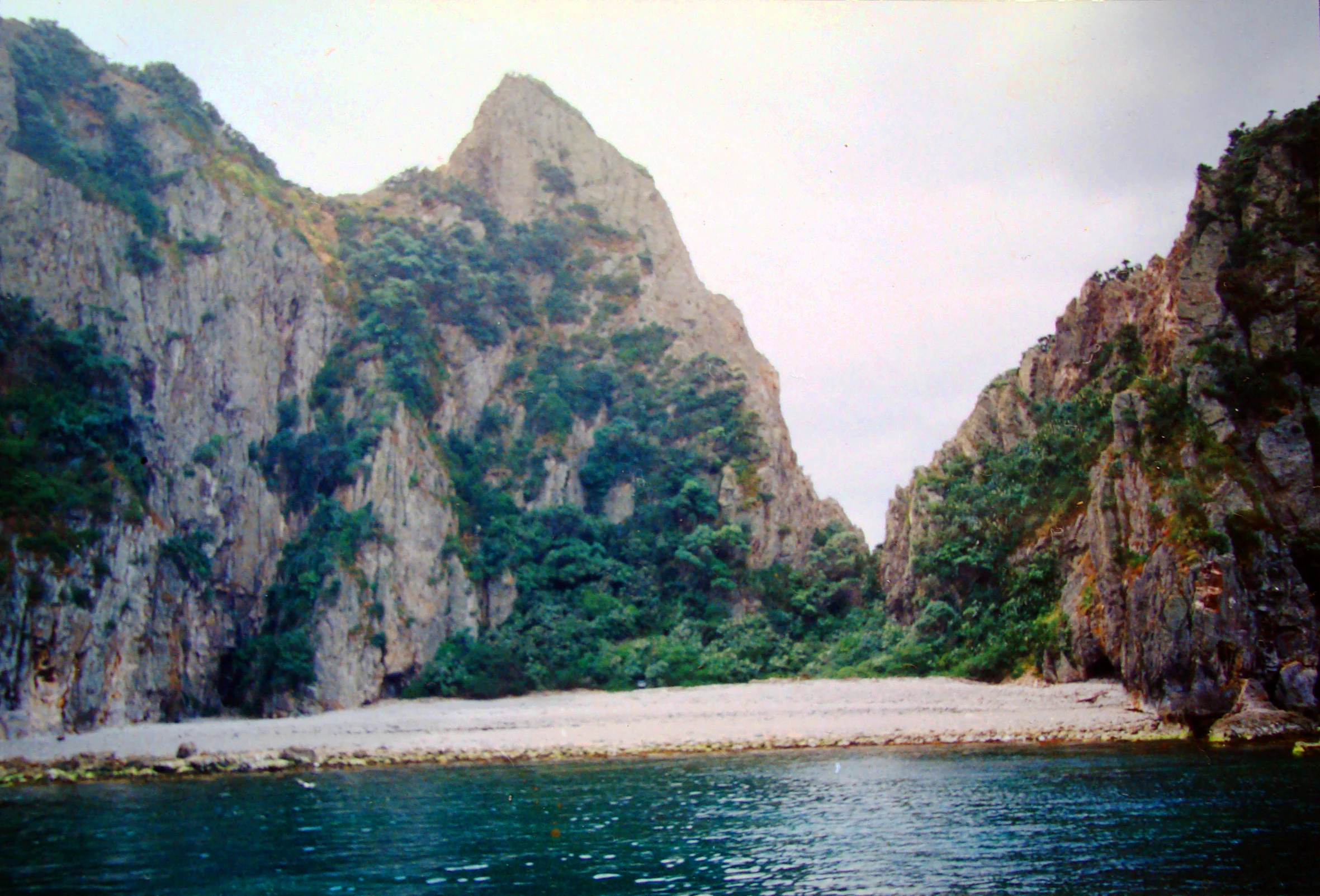
A view from the water looking at a sandy beach nestled between steep, rocky cliffs covered in green vegetation, with a prominent peak in the center.
A bay with a sandy beach surrounded by steep rocky cliffs and vegetation on the Aldermen Islands.

Aldermen Islands history and protected-area timeline

The islands were named 'the Court of Aldermen' by Captain James Cook and his crew on 3 November 1769, shortly after they had named Mayor Island nearby. The naming reflects the British maritime tradition of the time and gives the group its enduring English identity.

Beyond this early European naming, the islands' more recent history is defined by their protection. Designated as a forested nature reserve, the group has been managed primarily for conservation rather than settlement or industry. Their uninhabited status and permit-only access reflect a deliberate policy of limiting human impact in order to preserve the islands' ecological values, particularly the populations of rare native species that depend on relatively undisturbed habitat.

Aldermen Islands landscape and geographic character

The Aldermen Islands form a compact archipelago of rocky islets rising from the sea off the Coromandel coast. The four main islands, including Hongiora, Middle, Ruamahuanui, and Ruamahuaiti, dominate the group, while smaller features such as Big Hump, Little Hump, Nga Horo Island, Half Island, and The Spire add further complexity to the outline of the reserve.

The terrain is steep and irregular, shaped by the long erosion of ancient lava domes. Coastal forests blanket much of the available land, and the surrounding waters of Mercury Bay frame the islands with a Pacific maritime setting. The visual character of the group is one of rugged, forested silhouettes rising abruptly from the sea, with cliffs and rocky shores rather than long beaches.

Aldermen Islands ecosystems, habitats, and plant life

The ecological profile of the Aldermen Islands is dominated by coastal forest and the isolation-driven patterns typical of New Zealand's offshore reserves. With no permanent human population and limited access, the islands retain native vegetation cover across most of their area, providing habitat for species that have declined on the mainland.

The reserve forms part of a network of protected islands along the northeastern coast of the North Island that serve as refuges for endemic flora and fauna. The combination of rocky terrain, forest cover, and maritime climate supports vegetation communities adapted to salt-exposed conditions as well as more sheltered interior slopes. The islands' ecological value lies less in species richness than in the integrity of those habitats and the persistence of species that depend on predator-free, undisturbed environments.

Aldermen Islands wildlife and species highlights

The most prominent resident species of the Aldermen Islands is the tuatara, an ancient reptile endemic to New Zealand and the sole surviving member of an otherwise extinct order. Tuatara populations on offshore islands such as the Aldermens are of significant conservation interest, as they often represent genetically and demographically important populations isolated from mainland predators.

Beyond the tuatara, the islands provide habitat for native birdlife and other fauna typical of New Zealand's coastal forest reserves. The combination of forested cover, rocky terrain, and freedom from introduced predators supports a community that contrasts with the more modified ecosystems of the nearby Coromandel Peninsula mainland.

Aldermen Islands conservation status and protection priorities

Conservation is central to the identity of the Aldermen Islands. The group is administered as a forested nature reserve, and access is restricted to permit holders only, a measure designed to limit disturbance to native species and habitats. This restricted-access regime reflects the ecological vulnerability of the islands and the importance of maintaining their value as a refuge for rare wildlife.

The islands' conservation significance is heightened by their role in protecting the tuatara and other native species that have been lost from much of the mainland. Their isolation, combined with active protection, gives them a distinct role within the broader network of New Zealand offshore reserves managed for biodiversity preservation.

Aldermen Islands cultural meaning and human context

The Aldermen Islands carry historical significance through their naming by Captain James Cook during his 1769 voyage, when the group and nearby Mayor Island were given names reflecting civic British titles. This early European encounter established the English identity of the islands that persists today, while the islands themselves remain uninhabited and largely outside everyday cultural life.

Top sights and standout views in Aldermen Islands

The Aldermen Islands combine several qualities that make them distinctive among New Zealand's protected areas: a remote island setting off the Coromandel Peninsula, ancient volcanic origins as eroded lava domes, and an established role as a refuge for rare native wildlife such as the tuatara.

Their protected status as a forested nature reserve, together with permit-only access, ensures that the islands retain the ecological character that defines their significance. Although small in area and absent of visitor infrastructure, the Aldermens offer a clear example of how isolation and conservation management together preserve a living fragment of New Zealand's natural heritage.

Best time to visit Aldermen Islands

The Aldermen Islands can be considered primarily in terms of natural conditions rather than tourism seasons, as access is restricted by permit. Weather off the Coromandel coast is generally milder in the warmer months, when calmer seas and longer daylight hours make any permitted visits more feasible, while winter tends to bring rougher conditions that make small-island approaches more difficult. Wildlife observation and natural-history interest are relatively stable year-round, given the islands' protected status.

Monthly climate preview

Long-term representative point measurements tracking annual weather by month

Aldermen Islands Climate Normals, Average Temperature and Monthly Precipitation

Historical data records the annual temperature and precipitation rhythm across measured representative coordinates for Aldermen Islands. Reviewing these long-term monthly normals establishes foundational context before examining the complete twelve-month climate profile.
Annual mean16 °C
13 °C20 °C
Jan19°
Feb20°
Mar19°
Apr18°
May16°
Jun14°
Jul13°
Aug13°
Sep14°
Oct15°
Nov16°
Dec18°
Warmest month
February

20.2 °C

Coolest month
August

13.2 °C

Wettest month
July

4.1 mm/day

Driest month
November

2.1 mm/day

Park location guide

Geography guide, regional context, and park location map for Aldermen Islands

Aldermen Islands park geography, regions, and map view in New Zealand

Understand where Aldermen Islands sits in New Zealand through a broader geographic reading of the surrounding landscape, nearby location context, and its mapped position within the national park landscape.

How Aldermen Islands fits into New Zealand

New Zealand is an island nation in the southwestern Pacific Ocean comprising two main islands and numerous smaller islands. Located east of Australia across the Tasman Sea, it features varied topography with the Southern Alps running along the South Island and volcanic terrain on the North Island. The country was settled by Maori people between 1280 and 1350, followed by European exploration beginning in 1642, and became a Dominion in 1907 before gaining full independence in 1947.

Wider geography shaping Aldermen Islands in New Zealand

New Zealand lies in the southwestern Pacific Ocean, east of Australia across the Tasman Sea. The country consists of two main islands, the North Island and South Island, plus over 600 smaller islands. The North Island features volcanic plateaus and hills while the South Island is dominated by the Southern Alps mountain range. The country has a long coastline and is surrounded by the Pacific Ocean.

Map view of Aldermen Islands

Use this park location map to pinpoint Aldermen Islands in New Zealand, understand its exact geographic position, and read its mapped placement within the surrounding landscape more clearly.

Pigeon | © OpenStreetMap contributors

Examine the rugged terrain, coastal forests, and volcanic islets of the reserve

Aldermen Islands Photos and Landscape Scenery Visual Exploration

Visual documentation captures the steep volcanic topography and dense coastal forests defining the Aldermen Islands archipelago. Photographic records reveal the remote protected landscape, illustrating habitat conditions across rocky shores and offshore islets.

A view from the water looking at a sandy beach nestled between steep, rocky cliffs covered in green vegetation, with a prominent peak in the center.

Park atlas

Compare adjacent coastal landscapes and remote island reserves in the surrounding region

Exploring Other Parks and Protected Areas Near Aldermen Islands

Browse nearby protected landscapes and related island reserves to continue comparing regional conservation areas after viewing Aldermen Islands. Expanding the geographic scope reveals connected coastal geography and offshore sanctuaries across the wider maritime territory.
Protected areaWaikato Region
About 38 km away#1 closest

West

Coromandel Forest Park: Geography and Protected Area Overview in Waikato, NZ

Native bushland, valley systems, and conservation geography.

Coromandel Forest Park comprises an expansive system of forested hills and valleys covering the heart of the Coromandel Peninsula. This protected area features dense native ecosystems, ranging from the accessible Kauaeranga Valley to the ecologically significant southern blocks. Use this atlas perspective to understand the terrain, boundaries, and conservation value of this essential Waikato Region landscape.

Area
718.99 km²
Established
1971
Relief
Upland
Climate
Temperate
Nature reserveNew Zealand
About 45 km away#2 closest

North

Mercury Islands Nature Reserve: Volcanic Landscapes and Protected Island Geography

A coastal island group off the Coromandel Peninsula, New Zealand

The Mercury Islands form a structured volcanic chain characterized by dramatic cliffs, sheltered coves, and critical pest-free ecosystems. This protected area holds international significance for its seabird colonies and the well-preserved archaeological sites associated with early Māori history across the islands.

Established
1769
Relief
Upland
Access
Remote access
Scope
Mixed
Wildlife reserveNew Zealand
About 66 km away#3 closest

Northwest

Cuvier Island Wildlife Reserve: Volcanic Geography and Conservation Sanctuary

Protected island terrain in New Zealand's Hauraki Gulf

Cuvier Island is a rugged, forested volcanic landmass serving as a protected wildlife sanctuary. This uninhabited site plays an essential role in New Zealand island restoration efforts, acting as a habitat for vulnerable seabirds and representing a unique intersection of volcanic topography and focused environmental recovery.

Area
1.95 km²
Relief
Upland
Access
Highly restricted
Scope
Mixed
Regional parkWaikato Region
About 70 km away#4 closest

West

Waharau Regional Park: Protected Coastal Forest and Hunua Ranges Gateway

Geographic landscape transition in the Waikato region

This protected area offers a deep look into the transition from native forest hill country to estuarine environments along the Firth of Thames. Spanning 170 hectares, it serves as a functional geographic corridor between the Hunua Ranges and the Hauraki Gulf, showcasing layered history and varied topography within the Waikato region.

Area
1.7 km²
Established
1979
Relief
Upland
Climate
Temperate
Nature reserveAuckland Region
About 80 km away#5 closest

West

Rotoroa Island Nature Reserve: Mapping the Geography of this Hauraki Gulf Sanctuary

A vital protected island terrain for native species and reforestation

Rotoroa Island serves as a managed conservation landscape within the Hauraki Gulf, defined by its role as a pest-free sanctuary for threatened bird populations and intensive native forest restoration. The island offers a distinct geography that combines maritime coastal terrain with a rich history of social welfare, preserved through intentional land management and active environmental rehabilitation efforts near the Auckland coast.

Area
0.82 km²
Established
2011
Relief
Lowland
Scope
Terrestrial
Regional parkAuckland Region
About 83 km away#6 closest

West

Waitawa Regional Park: Coastal Geography and Recreation Landscapes in Auckland

Mapped terrain along the Tāmaki Strait shoreline

Waitawa Regional Park serves as a notable example of repurposed land within the Auckland Region, featuring an open coastal landscape on the Tāmaki Strait. This protected space, formerly an industrial explosives site, now offers a unique geography of grassy tracks, beach access, and historical remnants. Its layout provides a specialized atlas view of coastal development and public land use for outdoor activity.

Area
1.88 km²
Established
2013
Relief
Upland
Climate
Temperate
Regional parkAuckland Region
About 90 km away#7 closest

West

Whakanewha Regional Park: Mapping the Protected Landscapes and Wetlands of Waiheke Island

Coastal forest and wetland geography in the Auckland Region

Whakanewha Regional Park serves as a vital protected area on Waiheke Island, known for its mature broadleaf forests and significant freshwater wetlands. The park provides a compact yet varied landscape of stream valleys and coastal ridgelines, representing a key component of the regional geography within the Hauraki Gulf, sheltered from broader environmental pressures.

Area
2.7 km²
Established
2007
Relief
Upland
Climate
Temperate
Wildlife reserveAuckland
About 103 km away#8 closest

West

Motuihe Island Wildlife Reserve: Protected Landscapes and Hauraki Gulf Geography

Ecological restoration and coastal island history near Auckland

Motuihe Island represents a significant case study in island conservation, featuring intensive native forest regeneration and successful wildlife reintroduction. The mapped landscape details an elongated island geography defined by coastal beaches, sandstone terrain, and rich archaeological layers, serving as a prominent protected reserve for the Auckland region.

Area
1.79 km²
Relief
Lowland
Climate
Subtropical
Access
Moderate access

Common questions about visiting, size, designation, and location context for Aldermen Islands

Aldermen Islands FAQs for park facts, access, geography, and protected area context

Find quick answers about Aldermen Islands, including protected-area facts, park geography, trail and visitor context, and how the park fits into its surrounding country and regional landscape.
MoriAtlas Explorer

Continue Your Protected Areas Search Across the Global Atlas

Deepen your exploration by continuing the structured search for national parks and protected areas worldwide. Utilize the comprehensive filtering capabilities to compare different conservation landscapes and refine your understanding of global park geography. Discover more about the distribution and characteristics of protected natural areas.

Global natural geography