Mori Atlas logo
Nature reserveAlte Elster und Rieke

Mapping the riverine geography, wetland mosaic, and protected habitats of the Schwarze Elster valley.

Alte Elster und Rieke Nature Reserve and the Protected Floodplain Landscapes of Brandenburg

(Naturschutzgebiet Alte Elster und Rieke)

Alte Elster und Rieke stands as a vital nature reserve within the Brandenburg region of Germany, specifically protecting a rare remaining section of the natural Schwarze Elster river floodplain. This protected area features a complex mosaic of old river arms, the lower course of the Riecke tributary, wet meadows, and riparian forest. By preserving these near-natural lowland river features, the reserve maintains essential connectivity for species such as the Eurasian beaver and diverse migratory bird populations.

floodplainwetlandriver valleylowland riverold river armwet meadow

Alte Elster und Rieke

Nature reserve

Park overview

Structured park overview, official facts, and landscape profile for Alte Elster und Rieke

Alte Elster und Rieke park facts, protected area profile, and essential visitor context

Review the core facts for Alte Elster und Rieke, including designation, size, terrain, visitor scale, habitats, and operating context in one park-focused overview.

About Alte Elster und Rieke

Alte Elster und Rieke is a compact but ecologically rich nature reserve at the southern edge of the town of Herzberg (Elster) in Brandenburg, within the Elbe-Elster district. Geographically it sits in the lowlands of the Schwarze Elster, a river whose valley was once characterized by wide, braided floodplain wetlands before large-scale hydraulic engineering reshaped it in the twentieth century.

What sets the reserve apart is precisely this legacy of regulation. As the Schwarze Elster was channelized, its former meanders and side arms were cut off from the main channel, while much of the surrounding wet grassland was drained for agriculture. Alte Elster und Rieke represents one of the few stretches where the older floodplain morphology, the connection between an old river arm and the small tributary Riecke, and a network of small standing waters and wet meadows have survived side by side. The reserve therefore preserves not only individual species but an entire, albeit reduced, lowland river floodplain system.

Ecologically, the area is structured around water. Stretches of near-natural brook, old arms, small ponds, wet meadows, reed zones, and the lower valley of the Riecke with its own sedimentation zones together create a finely varied mosaic. Around them, fragments of floodplain and wetland forest still carry the vegetation that once dominated the wider valley. More than 400 plant species, around 82 breeding bird species, eight amphibian species, several reptile species, and roughly 20 fish species have been recorded here, making the site disproportionately important for regional biodiversity.

Institutionally, the area carries protected-area code 1340 and is recorded in the World Database on Protected Areas under WDPA ID 14432. It is treated as an IUCN Category IV Habitat/Species Management Area and is integrated into Natura 2000 planning for the middle course of the Schwarze Elster, which gives it a concrete framework for ongoing habitat maintenance and species monitoring.

Quick facts and research context for Alte Elster und Rieke

Alte Elster und Rieke is a designated nature reserve in the Elbe-Elster district of Brandenburg, in eastern Germany. It lies south of Herzberg (Elster) and northwest of Bahnsdorf, straddling the Schwarze Elster between the L 67 to the west and the B 101 to the east.

The reserve covers roughly 175.6 hectares and carries the protected-area identifier 1340; its WDPA record is 14432. It was placed under protection by ordinance on 26 March 1981, with a renewed ordinance on 1 July 2007, and is managed under IUCN Category IV as a habitat and species management area. The site is embedded in the Natura 2000 management planning for the middle course of the Schwarze Elster.

Protection and recognition

Terrestrial conservation scope, establishment year, and formal designation records

Alte Elster und Rieke Protection Status and Designated Area History

Alte Elster und Rieke maintains a documented terrestrial protection status established in 2007 within the global database registry. Formal designation history and management scope provide clear baseline facts for the protected landscape.

Protection details

Protection scope
Terrestrial
Designated year
2007
Transboundary protection
No
WDPA ID
14432
Park context

Deeper park guide and search-rich context for Alte Elster und Rieke

Alte Elster und Rieke history, landscape, wildlife, and travel context

Explore Alte Elster und Rieke through its history, landscape character, ecosystems, wildlife, conservation priorities, cultural context, and seasonal travel timing in a structured park guide built for atlas discovery and search intent.

Why Alte Elster und Rieke stands out

Alte Elster und Rieke is best known for preserving one of the last near-natural sections of the formerly extensive lowland floodplain of the Schwarze Elster. The reserve's combination of an old, cut-off river arm, the lower course of the Riecke tributary, oxbow features, small ponds, wet meadows, and floodplain forest makes it a textbook example of a surviving regulated-river refuge in the North German lowlands. It is also recognized for its role in safeguarding wetland species that depend on this kind of habitat, above all the Eurasian beaver, for which the area is explicitly mentioned as an important living space. Beyond that, it supports a notably rich diversity of breeding birds, amphibians, and aquatic plants in a region where most comparable floodplain wetlands have disappeared.
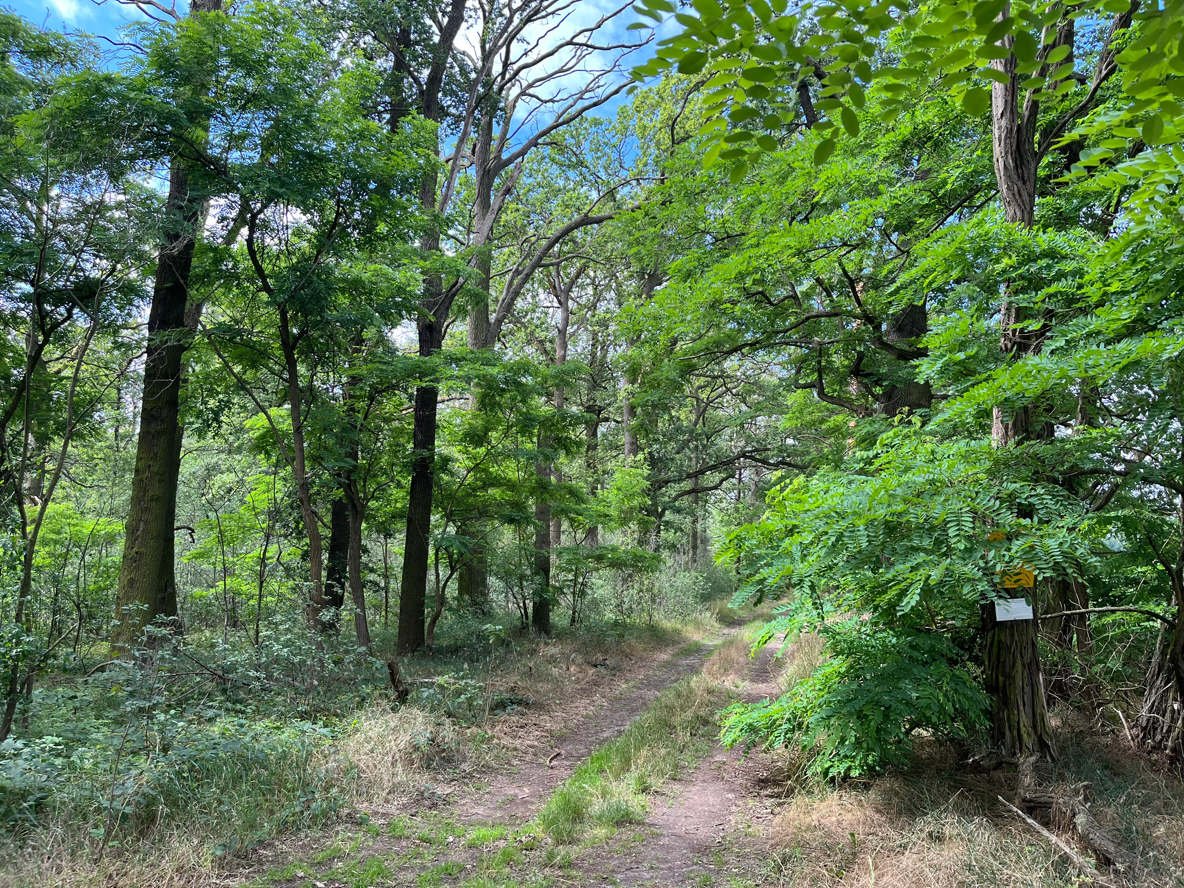
A dirt trail leads into a lush, green deciduous forest with a small trail marker attached to a tree trunk on the right.
A narrow forest path winds through the floodplain vegetation of the Alte Elster und Rieke nature reserve.

Alte Elster und Rieke history and protected-area timeline

The reserve's history is inseparable from the transformation of the Schwarze Elster during the twentieth century, when most of the river's natural floodplain sections were straightened and confined. As the main channel was regulated for flood control and land reclamation, older meanders and side arms were cut off, while the surrounding wet meadows were progressively drained and converted to farmland. What remained of the historic floodplain landscape was reduced to a scattering of smaller, disconnected wet areas.

Against this backdrop of regional habitat loss, the Alte Elster und Rieke area was recognized as a refuge that still held near-natural features: an old Elster arm, the lower course of the Riecke tributary, and the associated wet meadows and small waters. It was formally placed under nature protection by ordinance on 26 March 1981, establishing it as one of the early statutory nature reserves in what was then the GDR's southern Brandenburg landscape. A renewed ordinance on 1 July 2007 updated its protection framework and consolidated its role within Brandenburg's modern protected-area system.

In more recent decades the reserve has been integrated into the Natura 2000 network through management planning for the middle course of the Schwarze Elster, joining the broader effort to maintain and gradually restore floodplain functions along this heavily modified lowland river.

Alte Elster und Rieke landscape and geographic character

The landscape of Alte Elster und Rieke is defined by a lowland river valley at the southern edge of the North German plain. The terrain is flat to gently undulating, organized around the shallow valley of the Schwarze Elster and the lower course of its small tributary Riecke. There are no dramatic landforms; the scenery is shaped instead by the interplay of water surfaces, soft banks, and open wet grassland.

Within this gentle setting, the reserve preserves an old, partially cut-off arm of the Schwarze Elster, the near-natural lower reaches of the Riecke, and a network of small standing waters and shallow margins. Reed beds, sedge stands, and wet meadows fringe these waters, giving way to patches of floodplain and riparian woodland along the more stable banks. The surrounding agricultural land uses the higher, drained parts of the former floodplain, against which the protected wetland stands out as a clearly delineated green corridor.

Alte Elster und Rieke ecosystems, habitats, and plant life

Ecologically, Alte Elster und Rieke belongs to the lowland riparian and wetland systems characteristic of the middle course of the Schwarze Elster. The protected area is built around a small but complete suite of floodplain habitats: a near-natural stream course, old river arms, oxbow-like features and backwaters, small ponds and pools, reed- and sedge-dominated wet zones, moist meadows, and the transitional fringes of floodplain forest.

These habitats together support over 400 recorded plant species, a striking diversity for an area of its size. Characteristic wetland plants include marsh trefoil (Fieberklee), marsh gentian (Lungen-Enzian), burnet saxifrage relatives such as the Sumpf-Brenndolde, the aquatic Krebsschere, and the Wasserfeder, an indicator of clean, calcareous-influenced wetland waters. Their presence underlines the reserve's ecological value as one of the few places along the regulated Schwarze Elster where such a full range of wetland vegetation still occurs.

For animals, the value of the site lies in its structural complexity at a small scale. Old arms, side channels of the Riecke, reed beds, and wet meadows offer breeding, feeding, and sheltering conditions that have largely disappeared elsewhere in the valley. This makes the reserve a key local stronghold for wetland-dependent fauna in southern Brandenburg, including species whose regional status has become precarious since the original floodplain was fragmented.

Alte Elster und Rieke wildlife and species highlights

Alte Elster und Rieke supports a remarkably rich fauna for its size, reflecting the diversity of its wetland habitats. Among mammals, the Eurasian beaver is a flagship species and a central reason for the reserve's protection; the Eurasian otter is also recorded here. Both species depend on exactly the kind of intact riparian and wetland mosaic that the reserve preserves.

The reserve is particularly notable for its birdlife, with around 82 breeding bird species documented, including several of conservation concern such as the great reed warbler (Drosselrohrsänger), the Eurasian woodcock (Waldschnepfe), the penduline tit (Beutelmeise), the ortolan bunting (Ortolan), and the whinchat (Braunkehlchen). Their presence in a relatively small area underscores how the combination of reed, wet meadow, scrub, and woodland edges creates breeding niches that the broader, drained landscape can no longer provide.

Amphibians and reptiles are also well represented, with eight amphibian species and five reptile species recorded. Among them, the European pond turtle (Sumpfschildkröte) was last documented in 1990, marking it as a locally lost but historically characteristic wetland species. In the waters themselves, roughly 20 fish species occur, including the brook lamprey (Bachneunauge), an indicator of relatively undisturbed small watercourses. The site also hosts numerous moths, dragonflies, and beetles, adding an important invertebrate layer to its ecological identity.

Alte Elster und Rieke conservation status and protection priorities

The conservation significance of Alte Elster und Rieke lies in what it still retains of a once widespread landscape. During the twentieth century, the Schwarze Elster was regulated on a large scale: its meanders were cut off, its floodplain was narrowed, and many of its wet meadows were drained and farmed. Today only a handful of near-natural floodplain remnants remain, and Alte Elster und Rieke is one of them.

The reserve's stated purpose is the preservation and development of this floodplain area as habitat, with its near-natural stream course, old river arms, small standing waters, and wet meadows. Particular emphasis is placed on the Eurasian beaver as a target species, and on the lower course of the Riecke with its sedimentation zones and accompanying floodplain forest. The reserve thus acts as a refugium for plant and animal species that are endangered regionally or even nationally, especially those tied to wetland and floodplain conditions.

In administrative terms, the site is protected as a statutory nature reserve (Naturschutzgebiet) under the ordinances of 26 March 1981 and 1 July 2007, and is classified at the international level as an IUCN Category IV Habitat/Species Management Area. It is also integrated into Natura 2000 through the management plan for the middle course of the Schwarze Elster, which links its local conservation efforts to the broader aim of maintaining and where possible restoring floodplain functions along the river.

Top sights and standout views in Alte Elster und Rieke

Alte Elster und Rieke's strongest points of distinction are all tied to its floodplain character. It preserves a near-natural stream course and old river arms of the Schwarze Elster, the lower course of the small tributary Riecke with its sedimentation zones, and a coherent mosaic of wet meadows, small ponds, and floodplain forest on roughly 175 hectares in southern Brandenburg.

Within this landscape, the reserve concentrates an unusual density of regionally important species, from beaver and otter to about 82 breeding bird species, eight amphibians, five reptiles, around 20 fish species, and more than 400 plant species. Its formal protection status as a statutory nature reserve under both 1981 and 2007 ordinances, its IUCN Category IV classification, and its integration into Natura 2000 management of the middle Schwarze Elster together give it lasting conservation weight.

Best time to visit Alte Elster und Rieke

The reserve is a wetland landscape whose character shifts with the seasons rather than with formal opening times. Late spring into early summer is generally the period when wetland vegetation is most expressive, when reed beds and wet meadows are green, and when breeding birds are most actively present around the old river arms and along the Riecke.

In autumn, the area takes on softer tones as meadows and floodplain forest change color, and beaver and other mammals are often more visible along the quieter water edges. Winter, when the vegetation thins and the open water stands out, can make it easier to read the wider landscape structure of arms, meadows, and woodland patches, though conditions on the wet ground can be demanding.

Monthly climate preview

Long-term representative temperature ranges and monthly precipitation patterns

Alte Elster und Rieke Climate Normals and Annual Weather by Month

Alte Elster und Rieke exhibits measured annual temperature variations from sub-zero winter minimums to warm summer maximums alongside consistent monthly precipitation. Reviewing the complete twelve-month climate profile reveals detailed thermal rhythms across the representative protected coordinate.
Annual mean9 °C
-1 °C20 °C
Jan-1°
Feb
Mar
Apr
May14°
Jun18°
Jul20°
Aug20°
Sep15°
Oct
Nov
Dec
Warmest month
July

20 °C

Coolest month
January

-0.7 °C

Wettest month
July

2.6 mm/day

Driest month
April

1.1 mm/day

Park location guide

Geography guide, regional context, and park location map for Alte Elster und Rieke

Alte Elster und Rieke park geography, regions, and map view in Germany

Understand where Alte Elster und Rieke sits in Germany through a broader geographic reading of the surrounding landscape, nearby location context, and its mapped position within the national park landscape.

How Alte Elster und Rieke fits into Germany

Germany is a federal republic in Western and Central Europe with a population of over 83 million across sixteen constituent states. It is Europe's largest economy by nominal GDP and a major global exporter and importer. The capital is Berlin, and the country borders Denmark, Poland, Czech Republic, Austria, Switzerland, France, Luxembourg, Belgium, and the Netherlands.

Wider geography shaping Alte Elster und Rieke in Germany

Germany is located in Western and Central Europe, spanning 357,022 km². It borders Denmark to the north, Poland and the Czech Republic to the east, Austria and Switzerland to the south, and France, Luxembourg, Belgium, and the Netherlands to the west. The country has coastlines on the Baltic Sea and North Sea to the north, with the Alps located in the southern region.

Map view of Alte Elster und Rieke

Use this park location map to pinpoint Alte Elster und Rieke in Germany, understand its exact geographic position, and read its mapped placement within the surrounding landscape more clearly.

Pigeon | © OpenStreetMap contributors

Location context for Alte Elster und Rieke

Brandenburg

Visual exploration of floodplain habitats and wetland terrain in southern Brandenburg

Alte Elster und Rieke Photos and Landscape Scenery

Photographic documentation reveals the distinct river valley terrain, old water arms, and surviving wetland habitats of Alte Elster und Rieke. Visual records provide essential context for understanding the protected floodplain ecosystem and its rare lowland characteristics.

A dirt trail leads into a lush, green deciduous forest with a small trail marker attached to a tree trunk on the right.

Park atlas

Compare adjacent wetland reserves and surrounding lowland river geography

Explore Protected Areas and Parks Near Alte Elster und Rieke

Browsing other protected areas near Alte Elster und Rieke reveals broader regional wetland networks and remaining lowland river habitats. Comparing these connected conservation landscapes provides deeper context on floodplain ecology across the surrounding region.
Nature reserveBrandenburg
About 20 km away#1 closest

East

Lehmannsteich Nature Reserve: Geographic Atlas of Brandenburg Protected Lowlands

Atlantic wet heath and bog-hollow conservation landscapes.

Discover the complex landscape of Lehmannsteich, a 140-hectare nature reserve in Brandenburg. This protected area showcases a distinctive transition from wet heath and peat-filled sloughs to surrounding pine woodland, illustrating the rare inland habitat types found within the Elbe-Elster region.

Area
1.405 km²
Established
1981
IUCN
IV
A horizontal watercolor painting showing a soft, atmospheric wetland scene with green meadows, tall grasses, distant tree lines, and a pale pink and yellow sky.
Nature reserveBrandenburg
About 21 km away#2 closest

South

Kleine Röder Nature Reserve: Mapped Wetland Geography and Protected Landscape in Brandenburg

A vital Elbe-Mulde lowland corridor near Bad Liebenwerda

The Kleine Röder Nature Reserve functions as a major ecological link in northeastern Germany, protecting a 385 hectare mosaic of fens, wet meadows, and alluvial forests. This site is defined by its water-dominated terrain and its role as a habitat corridor in the Elbe-Mulde lowland, encompassing both rare wetland flora and the historic Kosilenzien Slavic ringwall within its official boundaries.

Area
3.65 km²
Established
2011
IUCN
IV
A soft watercolor painting of a green, marshy landscape with a winding waterway and rolling hills in the background.
Nature reserveSaxony
About 23 km away#3 closest

Southwest

Großer Teich Torgau: A Protected Saxon Reservoir and Historic Wetland Map

Exploring the medieval pond culture and nature reserve boundaries in Saxony

Located in northern Saxony, Großer Teich Torgau is a rare surviving medieval fish pond that functions as a nature reserve and flood management reservoir. This protected landscape contains shallow water zones, historic earthen dam structures, and surrounding marshlands that illustrate centuries of continuous human and natural interaction within the regional geography.

Area
1.75 km²
Established
1484
Relief
Lowland
Scope
Terrestrial
A minimalist watercolor painting showing a horizontal landscape with patches of green forest and hints of marshy or open terrain against a white background.
Protected landscapeBrandenburg
About 25 km away#4 closest

Southeast

Naturpark Niederlausitzer Heidelandschaft: A Protected Landscape in Brandenburg

Mapping the glacial remnants and industrial heritage of a German lowland nature park

Naturpark Niederlausitzer Heidelandschaft offers an insightful look into the transformation of Brandenburg lowlands, where sessile oak forests, wet meadows, and post mining residual waters create a singular ecological mosaic. This destination captures the contrast between remnants of the last ice age and the deliberate rewilding of former opencast pits, providing a deep view into regional landscape evolution.

Area
484.3 km²
Established
1996
Relief
Lowland
Climate
Temperate
A soft watercolor painting depicting a pale, hazy landscape with green grassy fields, light green trees, and distant faint mountains under a pastel sky.
Protected areaSaxony
About 25 km away#5 closest

South

Gohrischheide und Elbniederterrasse Zeithain: Geography and Protected Area Overview

Analyzing the inland dunes and dry heath landscape of the Elbe river terrace

Discover the unique geography of Gohrischheide und Elbniederterrasse Zeithain in Saxony, a protected area known for its expansive inland dunes and dry heath habitats. This region represents a rare combination of post-glacial sand landscapes and semi-open forest mosaics that reflect long-term ecological evolution and distinct regional environmental conditions.

Area
28.47 km²
Established
2011
Relief
Lowland
Climate
Temperate
Nature reserveBrandenburg
About 36 km away#6 closest

Southeast

Welkteich Nature Reserve: Brandenburg Industrial Legacy and Protected Habitat Mapping

Mapping a unique mosaic of post-mining terrain and historic pond systems

Located in the district of Oberspreewald-Lausitz, Welkteich represents a distinct example of how industrial-era mining scars and artificial ridges can evolve into protected nature reserves. The site serves as a vital ecological corridor, featuring a dense interspersion of aquatic basins, forest patches, and dry ground that provides a sanctuary for diverse species within the broader Brandenburg landscape.

Area
1.13 km²
Established
1981
IUCN
IV
Relief
Lowland
A horizontal watercolor painting showing a soft, impressionistic landscape with a winding stream, surrounding marshy vegetation, trees, and distant rolling hills in pale green and pink tones.
Nature reserveBrandenburg
About 37 km away#7 closest

Northeast

Borcheltsbusch und Brandkieten: Nature Reserve and Protected Landscape in Brandenburg

Wetland and forest mosaic on the Lower Lusatian land ridge.

Borcheltsbusch und Brandkieten is a nature reserve in Brandenburg, preserving critical moorland and forest habitats. Its geography includes the Berste river corridor and a connection to nearby protected forest zones. This site provides a clear view into the region's managed peatland and lowland forest ecosystems and their long-term conservation importance.

Area
1.42 km²
Established
1981
IUCN
IV
Scope
Terrestrial
Protected landscapeBrandenburg
About 39 km away#8 closest

East

Naturpark Niederlausitzer Landrücken: A Protected Landscape in Brandenburg, Germany

Mapped terrain, post-mining wetlands, and glacial moraine features.

Located in the Lower Lusatia region of Brandenburg, Naturpark Niederlausitzer Landrücken showcases a remarkable geological and ecological narrative. The area contrasts traditional farmsteads and the forested Rochauer Heide with a vast, water-filled mosaic of opencast mining pits. This park serves as a primary site for understanding how industrial legacies evolve into significant wildlife habitats and protected natural terrain within the German state.

Area
587 km²
Established
1997
Relief
Upland
Climate
Temperate

Common questions about visiting, size, designation, and location context for Alte Elster und Rieke

Alte Elster und Rieke FAQs for park facts, access, geography, and protected area context

Find quick answers about Alte Elster und Rieke, including protected-area facts, park geography, trail and visitor context, and how the park fits into its surrounding country and regional landscape.
MoriAtlas Explorer

Continue Your Protected Areas Search Across the Global Atlas

Deepen your exploration by continuing the structured search for national parks and protected areas worldwide. Utilize the comprehensive filtering capabilities to compare different conservation landscapes and refine your understanding of global park geography. Discover more about the distribution and characteristics of protected natural areas.

Global natural geography