

Mori Atlas logo
National parkAmami Guntō National Park

Discover the mapped boundaries and regional geography of this vital national park.

Amami Guntō National Park: Protected Landscape and Geographic Atlas Context

(Amami Guntō Kokuritsu Kōen)

Amami Guntō National Park represents a key protected area within the archipelago of Kagoshima Prefecture, Japan. This national park offers significant opportunities for exploring its unique protected landscape and its placement within the broader geographic context of the Ryukyu Islands. Understand the mapped park boundaries and regional distribution of conservation lands across this vital natural territory.

National ParkSubtropical IslandsCoral ReefsMangrove ForestsEndemic SpeciesKarst Topography

Amami Guntō National Park

National park

Park overview

Structured park overview, official facts, and landscape profile for Amami Guntō National Park

Amami Guntō National Park park facts, protected area profile, and essential visitor context
Review the core facts for Amami Guntō National Park, including designation, size, terrain, visitor scale, habitats, and operating context in one park-focused overview.

About Amami Guntō National Park

Amami Guntō National Park protects a remarkable island archipelago in the Amami Islands chain, located in the waters between Kyushu and Okinawa in southern Japan. The park encompasses eight islands that together form a distinctive subtropical protected area combining terrestrial forests, coastal landscapes, and marine environments. Established in 2017 through the elevation of a former quasi-national park, Amami Guntō represents one of Japan's newer national parks and reflects growing recognition of the islands' exceptional biodiversity value.

The park's significance extends beyond its ecological features to encompass geological diversity across its constituent islands. Each island within the park offers distinct landscape character, from the limestone karst terrain of Tokunoshima to the coastal terraces of Kikai and the coral-fringed shores of Yoron. The park includes valuable subtropical hardwood forests, particularly on Yuwandake in the Amami Ōshima and Kakeromajima area, where species such as Castanopsis sieboldii and Neolitsea aciculata create dense forest cover. The underwater environments feature coral reef systems, mangrove forests at river mouths such as the Katsushi River, and tidal flats that together form interconnected coastal ecosystems.

Quick facts and research context for Amami Guntō National Park

Amami Guntō National Park is located in the Amami Islands chain of southern Japan, spanning eight islands: Tokunoshima, Kikai, Amami (Amami Ōshima), Yoron, Okinoerabujima, Uke Island, Kakeromajima, and Yoroshima. The park covers 42,181 hectares of land and 33,082 hectares of marine area, making it one of Japan's larger national parks in terms of combined land and water protection. The park was established on March 7, 2017, succeeding the Amami Guntō Quasi-National Park that had existed since 1974. The park falls under IUCN Category II protection and is part of a broader effort to have the Amami Islands, along with Yanbaru and Iriomote, inscribed as a UNESCO World Heritage Site.

Park context

Deeper park guide and search-rich context for Amami Guntō National Park

Amami Guntō National Park history, landscape, wildlife, and travel context
Explore Amami Guntō National Park through its history, landscape character, ecosystems, wildlife, conservation priorities, cultural context, and seasonal travel timing in a structured park guide built for atlas discovery and search intent.

Why Amami Guntō National Park stands out

Amami Guntō National Park is best known for its remarkable concentration of endemic species and diverse subtropical ecosystems spanning both land and sea. The park protects the Amami rabbit, a primitive rabbit species found only on Amami Ōshima and Tokunoshima, as well as the Ryukyu spiny rat. Its marine environments feature extensive coral reef systems and mangrove forests that support complex coastal ecosystems. The park encompasses multiple island landscapes including the karst topography of Tokunoshima with its natural sea caves, the coastal terraces of Kikai, and the coral-surrounded coast of Yoron. The Amami Wildlife Center serves as an educational and research facility managed by Japan's Ministry of the Environment to support conservation of the islands' unique natural heritage.

Amami Guntō National Park history and protected-area timeline

Amami Guntō National Park traces its origins to February 15, 1974, when the Amami Guntō Quasi-National Park was established, initially covering areas on Amami Ōshima. This quasi-national park status provided a baseline level of protection for the islands' natural environments while recognition of their ecological importance continued to develop. On March 7, 2017, the area was elevated to full national park status, becoming Amami Guntō National Park and expanding to encompass parts of eight islands across multiple municipalities including Amagi, Amami, China, Isen, Kikai, Setouchi, Tatsugō, Tokunoshima, Uken, Wadomari, Yamato, and Yoron.

The designation as a national park was part of a broader conservation initiative that also included Yanbaru National Park in Okinawa. Together, these protected areas form the core of an effort to have Amami-Oshima Island, Tokunoshima Island, the northern part of Okinawa Island (Yanbaru), and Iriomote Island inscribed on the UNESCO World Heritage List. The Amami Wildlife Center, operated by Japan's Ministry of the Environment, serves as a key facility for research, education, and conservation efforts targeting the park's unique species and ecosystems.

Amami Guntō National Park landscape and geographic character

The landscape of Amami Guntō National Park is defined by its island setting and the dramatic contrast between mountainous interior terrain and coastal environments. The park's islands feature diverse geological formations that create varied scenery across relatively short distances. Tokunoshima stands out for its karst topography, characterized by limestone outcrops, sinkholes, and underground drainage systems, along with natural sea caves formed by coastal erosion. The island of Mt. Inokawa is noted for its treasure trove of endemic plants including numerous fern species.

Kikai Island displays prominent coastal terraces that mark ancient shoreline positions, while Hyakunodai Park preserves a plateau where coral reef formations have developed in what is now terrestrial terrain. Okinoerabujima features large cave systems including Shoryu Cavern and notable sea cliffs in the Minamata and Kunigamizaki areas. Yoron Island has nearly its entire coastline included within the park boundaries, surrounded by coral reefs that create exceptional underwater visibility and marine habitat complexity. The park also encompasses smaller islands including Uke Island, Kakeromajima, and Yoroshima, each contributing to the overall diversity of the island group.

Amami Guntō National Park ecosystems, habitats, and plant life

The nature of Amami Guntō National Park centers on its subtropical island ecosystems that have developed in isolation, resulting in high levels of endemism. The park encompasses three primary habitat types that together create a complex ecological mosaic: coral reefs in the marine zones, mangrove forests along sheltered coastlines and river mouths, and tidal flats that serve as crucial feeding grounds for diverse species. The terrestrial environments support subtropical hardwood forests that provide habitat for the park's endemic fauna.

The vegetation on Amami Ōshima and Kakeromajima features valuable subtropical hardwood forests dominated by species such as Castanopsis sieboldii and Neolitsea aciculata. These forests occur on slopes and in valleys, transitioning to coastal zones where mangrove species become established in the estuarine environments. The marine environments feature coral reef development that supports fish communities and other marine organisms, while the mangrove forests and tidal flats provide nurseries for juvenile fish and feeding habitat for shorebirds.

Amami Guntō National Park wildlife and species highlights

The wildlife of Amami Guntō National Park is distinguished by a high proportion of endemic species that evolved in isolation on these subtropical islands. The park protects two particularly notable mammalian species: the Amami rabbit (Pentalagus furnessii), a primitive rabbit species found only on Amami Ōshima and Tokunoshima that represents a ancient lineage separate from mainland rabbit species, and the Ryukyu spiny rat, which is also restricted to these islands.

The park supports significant bird populations including Lidth's jay, also known as Amami's jay, and the Ryukyu robin, both of which are endemic to the Amami Islands. Among reptiles and amphibians, the park is home to the Habu snake (a pit viper species), Ishikawa's frog, the Japanese warty newt (also called Anderson's crocodile newt), and the Ryūkyū scops owl. This combination of endemic mammals, birds, reptiles, and amphibians makes the park exceptionally important for biodiversity conservation in Japan and East Asia.

Amami Guntō National Park conservation status and protection priorities

Amami Guntō National Park represents a significant conservation achievement for Japan, protecting some of the nation's most biodiversity-rich island ecosystems. The park's designation as a candidate for UNESCO World Heritage status reflects international recognition of the outstanding universal value of these islands and their endemic species. The park's dual terrestrial and marine protection, encompassing 42,181 hectares of land and 33,082 hectares of sea area, provides comprehensive coverage of island ecosystems from mountain forests to coral reefs.

The Amami Wildlife Center operated by Japan's Ministry of the Environment plays a central role in conservation efforts, conducting research, public education, and species management programs. The park's establishment in 2017 marked the culmination of decades of conservation effort that began with the quasi-national park designation in 1974. Conservation challenges include managing the impacts of development pressure on these islands while maintaining the connectivity between terrestrial and marine habitats that many endemic species depend upon.

Amami Guntō National Park cultural meaning and human context

The Amami Islands have a distinct cultural identity that reflects their position between the Japanese main islands and Okinawa. The islands have historically been influenced by both Ryukyuan and mainland Japanese cultures, creating a unique regional heritage. The landscape of Amami Guntō National Park exists within this cultural context, as the protected areas span municipalities that have maintained traditional communities tied to the land and sea.

Local communities on these islands have historically depended on fishing, agriculture, and maritime activities that shape both the human landscape and the coastal environments included in the park. The relationship between island communities and their natural surroundings has evolved over generations, creating cultural practices that are intertwined with the islands' ecosystems. While the park focuses on ecological protection, this human dimension provides important context for understanding the islands' overall character and the significance of the landscapes being preserved.

Top sights and standout views in Amami Guntō National Park

The highlights of Amami Guntō National Park include its exceptional biodiversity with numerous endemic species, the diversity of island landscapes from karst terrain to coral reefs, and the comprehensive protection of both terrestrial and marine environments. The park provides opportunities to observe the rare Amami rabbit and other endemic species in their natural habitats, explore sea caves and geological formations on Tokunoshima, and experience coral reef ecosystems around Yoron. The Amami Wildlife Center offers educational programs about the islands' unique natural heritage. The park's recent establishment in 2017 and its UNESCO World Heritage candidate status underscore its significance as a conservation priority in East Asia.

Best time to visit Amami Guntō National Park

Amami Guntō National Park can be visited throughout the year due to its subtropical climate, though the summer months from June through September bring higher temperatures and increased humidity along with the potential for typhoons. Spring and autumn generally offer more comfortable conditions for outdoor exploration, with milder temperatures and lower typhoon risk. The marine environments are accessible for snorkeling and diving during the warmer months when water temperatures are suitable, though year-round interest exists in the islands' terrestrial trails and forest environments. Visitors interested in wildlife observation should consider that different species may be more active during different seasons, though the park's endemic species can be encountered throughout the year in appropriate habitats.
Park location guide

Geography guide, regional context, and park location map for Amami Guntō National Park

Amami Guntō National Park park geography, regions, and map view in Japan
Understand where Amami Guntō National Park sits in Japan through a broader geographic reading of the surrounding landscape, nearby location context, and its mapped position within the national park landscape.

How Amami Guntō National Park fits into Japan

Japan is an island nation in East Asia comprising over 14,000 islands in the Pacific Ocean. The country operates as a unitary parliamentary constitutional monarchy with Emperor Naruhito as the reigning monarch and Prime Minister Sanae Takaichi leading the government. With a population of approximately 123 million, Japan is the world's 11th most populous country and a major economic power with one of the strongest militaries, though it has constitutionally renounced its right to declare war.

Wider geography shaping Amami Guntō National Park in Japan

Japan is an island nation in the Pacific Ocean, bordered to the west by the Sea of Japan and extending from the Sea of Okhotsk in the north to the East China Sea in the south. The Japanese archipelago lies off the northeast coast of the Asian mainland. Approximately 75% of Japan's terrain is mountainous and heavily forested, with agricultural land and urbanized populations concentrated along the eastern coastal plains. The country is divided into 47 administrative prefectures and eight traditional regions.

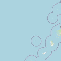
Map view of Amami Guntō National Park

Use this park location map to pinpoint Amami Guntō National Park in Japan, understand its exact geographic position, and read its mapped placement within the surrounding landscape more clearly.

Pigeon | © OpenStreetMap contributors

Location context for Amami Guntō National Park

Kagoshima Prefecture
Park atlas

Browse surrounding island geographies and compare protected landscapes across Japan's subtropical south.

Discover More National Parks and Protected Areas Near Amami Guntō National Park
Explore a curated list of national parks and protected areas located near Amami Guntō National Park, encompassing Japan's unique subtropical islands and their diverse ecosystems. Comparing these conservation landscapes provides valuable insights into regional biodiversity, shared geological features, and the spread of critical endemic species across the Amami archipelago and beyond.
National parkJapan

Kerama Shotō National Park: Okinawa's Subtropical Archipelago National Park

Mapped Coral Reefs and Island Protected Landscapes.

Kerama Shotō National Park, located in Japan's Okinawa Prefecture, offers a unique atlas exploration of marine and terrestrial protected areas. The park is globally recognized for its extensive coral reef systems, home to hundreds of coral species and crucial for marine biodiversity, including sea turtles and whales. Above the water, the park encompasses subtropical islands with rolling hills and unique flora, providing a rich contrast to its vibrant underwater environments. Discover this important addition to Japan's network of protected lands, characterized by its striking natural beauty and ecological significance.

Area
939.95 km²
Established
2014
IUCN
II
Relief
Lowland
National parkKagoshima Prefecture

Yakushima National Park: Ancient Cedar Forests and Volcanic Mountain Landscape

Discover the mapped boundaries and protected area geography.

Yakushima National Park, situated in Kagoshima Prefecture, is a prime example of protected island geography, renowned for its ancient yakusugi cedar trees and dramatic mountainous terrain. The park's protected status covers over 32,000 hectares, featuring peaks over 1,900 meters and significant biodiversity. This atlas-focused entry helps users grasp the park's unique landscape context, its position within Japan's protected areas, and the essence of its natural environment for geographic exploration.

Area
325.53 km²
Established
2012
IUCN
II
Relief
Mountain
National parkJapan

Kirishima-Kinkowan National Park: Exploring Japan's National Park Geography and Mapped Boundaries

A protected landscape within Japan's diverse terrain.

Kirishima-Kinkowan National Park represents a distinct protected area within Japan, offering critical insights for geographic exploration. This page details the park's specific mapped boundaries and its contribution to the regional landscape. Understanding this national park provides a structured entry point for exploring Japan's protected natural areas and their unique geographical characteristics through an atlas lens.

Area
365.86 km²
Established
1934
IUCN
II
Relief
Mountain
National parkNagasaki Prefecture

Saikai National Park: Japan National Park Geography and Protected Area Mapping

Explore Nagasaki Prefecture's protected natural landscapes.

Delve into the detailed geographic information and protected area context of Saikai National Park. As a national park situated in Nagasaki Prefecture, it represents a key area for understanding Japan's regional geography and its network of protected lands. This entry facilitates atlas-based discovery of the park's boundaries, its terrain, and its unique role within the mapped landscape of Kyushu.

Area
246.46 km²
Established
1955
IUCN
II
Visitors
4.6M annual
National parkNagasaki Prefecture

Unzen-Amakusa National Park: Volcanic Terrain and Island Geography

Explore Nagasaki Prefecture's Protected Landscape

Unzen-Amakusa National Park represents a significant protected area within Japan's geography, characterized by the imposing presence of Mount Unzen and the distinct maritime environment of the Amakusa islands. This national park offers an opportunity to study volcanic landscapes, coastal formations, and the rich cultural history intertwined with its natural setting. Understanding its mapped boundaries and geographic context provides valuable insight into Japan's protected lands and regional landscape diversity.

Area
282.79 km²
Established
1934
IUCN
II
Relief
Mixed relief
National parkŌita Prefecture

Aso-Kujū National Park: Ōita Prefecture's Protected Landscape Atlas

Mapped boundaries and regional geographic context for this national park.

Delve into the protected landscape of Aso-Kujū National Park, situated within the geographic region of Ōita Prefecture. This page provides detailed insight into the park's mapped terrain, its designation as a national park, and its contribution to the atlas of protected areas. Understand the park's landscape context and its significance as a conserved natural area.

Area
726.78 km²
Established
1934
IUCN
II
Relief
Mountain
National parkOkinawa Prefecture

Iriomote-Ishigaki National Park: Subtropical Island Geography and Protected Landscape Atlas

Explore the unique terrain and mapped boundaries of this national park.

Dive into the geography of Iriomote-Ishigaki National Park, a protected national park situated in Japan's Okinawa Prefecture. This page provides a detailed atlas view of its characteristic subtropical island terrain, including extensive mangrove forests, distinct limestone karst features, and surrounding marine protected areas. Understand the park's unique landscape and its significance within the broader regional geography for comprehensive exploration.

Area
1,221.5 km²
Established
1972
IUCN
II
Climate
Subtropical
National parkJeju Province

Hallasan National Park: South Korea's Highest Mountain National Park on Jeju

Volcanic Terrain and Mapped Protected Boundaries

Hallasan National Park encompasses South Korea's highest mountain, a massive shield volcano on Jeju Island. This page details the park's protected landscape, from sub-tropical forests to alpine environments, and its prominent role within Jeju Province's geography. Discover its mapped terrain and unique geological features, including the summit crater lake Baekrokdam.

Area
153.11 km²
Established
1970
IUCN
II
Relief
Mountain

Common questions about visiting, size, designation, and location context for Amami Guntō National Park

Amami Guntō National Park FAQs for park facts, access, geography, and protected area context
Find quick answers about Amami Guntō National Park, including protected-area facts, park geography, trail and visitor context, and how the park fits into its surrounding country and regional landscape.
MoriAtlas Explorer

Continue Your Protected Areas Search Across the Global Atlas

Deepen your exploration by continuing the structured search for national parks and protected areas worldwide. Utilize the comprehensive filtering capabilities to compare different conservation landscapes and refine your understanding of global park geography. Discover more about the distribution and characteristics of protected natural areas.

Global natural geography