

Mori Atlas logo
Wildlife reserveRéserve spéciale d'Ambatovaky

A rugged conservation corridor featuring complex river valleys, dense rainforests, and critical endemic habitats.

Réserve spéciale d'Ambatovaky: Protected Wildlife Reserve and Forested Landscape Map in Analanjirofo, Madagascar

Réserve spéciale d'Ambatovaky represents a vital protected landscape within the eastern escarpment of Madagascar. Spanning a rugged, densely forested terrain between the Marimbona and Simianona rivers, the reserve functions as a connective forest block in the Analanjirofo region. Its complex topography of dissected hills, cliffs, and river corridors supports diverse endemic species, including eleven documented lemur species and the rare Madagascar serpent eagle.

Madagascar reserveseastern rainforesthumid forestlowland rainforesthill forestlemur habitat

Réserve spéciale d'Ambatovaky

Wildlife reserve

Park overview

Structured park overview, official facts, and landscape profile for Ambatovaky Special Reserve

Ambatovaky Special Reserve park facts, protected area profile, and essential visitor context

Review the core facts for Ambatovaky Special Reserve, including designation, size, terrain, visitor scale, habitats, and operating context in one park-focused overview.

About Ambatovaky Special Reserve

Ambatovaky Special Reserve occupies a significant block of humid forest on the eastern side of Madagascar, in the Analanjirofo region north of the town of Fénérive and north of the coastal town of Soanierana Ivongo. It is one of the older protected areas in Madagascar, having been established in 1958, and it has long functioned as a key piece in the country's eastern rainforest conservation network.

Geographically, the reserve sits within a broader corridor of protected rainforest that hugs Madagascar's northeastern coast. To its northwest, the terrain continues into the Makira plateau and onward into Masoala National Park, while the Mananara National Park lies to its north. To its south, the landscape extends into the Zahamena Strict Nature Reserve. This pattern of contiguous or closely linked protected areas means that Ambatovaky is rarely discussed in isolation; its ecological importance is closely tied to the surrounding matrix of parks and reserves that together form one of the largest remaining blocks of eastern Malagasy rainforest.

The reserve itself is characterized by steep, broken terrain. Cliffs rise above densely vegetated valleys, and the overall relief is described as hilly and rugged, with thick forest cover extending across ridges and slopes. Two major rivers define its boundaries: the Marimbona River forms the southern limit, and the Simianona River runs along the northern edge. The rivers, the cliffs, and the dense vegetation together create a physically challenging environment that has historically limited access, which in turn has helped preserve relatively intact forest cover and the wildlife it supports.

Ecologically, Ambatovaky belongs firmly to Madagascar's eastern rainforest biome, a zone of high endemism and exceptional botanical diversity. Surveys recorded within the reserve have documented a substantial number of plant species, the great majority of which are endemic to Madagascar. This concentration of endemic plants reflects the broader biogeographic character of the eastern forests, where many lineages have evolved in isolation from the African mainland and from the drier western forests of the island.

The reserve is administered as a Madagascar Special Reserve, corresponding to IUCN Category IV, which in Madagascar's system is used for areas where habitat and species conservation is actively managed. Beyond its formal administrative status, however, Ambatovaky's broader significance lies in its role as a connective reserve, helping to maintain ecological continuity between Masoala, Mananara, and Zahamena, and contributing to the long-term viability of forest-dependent species across this part of northeastern Madagascar.

Quick facts and research context for Ambatovaky Special Reserve

Ambatovaky Special Reserve is located in the Analanjirofo region of northeastern Madagascar and is administered as a Madagascar Special Reserve under IUCN Category IV, a designation covering areas managed mainly for habitat and species conservation through active intervention.

The reserve was established in 1958 and covers a substantial area of lowland and submontane rainforest on Madagascar's eastern slope. It shares its southern limit with the Marimbona River and its northern limit with the Simianona River, while connecting to Masoala National Park via the Makira plateau to the northwest and to the Zahamena Strict Nature Reserve to the south.

Protection and recognition

Documented conservation status and administrative designation records

Réserve spéciale d'Ambatovaky Protection Status and Territorial Scope

Terrestrial protection status and documented conservation records define the baseline management framework for Réserve spéciale d'Ambatovaky. Structured data provides verified boundary records and official protection parameters for conservation analysis.

Protection details

Protection scope
Terrestrial
WDPA ID
5037
Park context

Deeper park guide and search-rich context for Ambatovaky Special Reserve

Ambatovaky Special Reserve history, landscape, wildlife, and travel context

Explore Ambatovaky Special Reserve through its history, landscape character, ecosystems, wildlife, conservation priorities, cultural context, and seasonal travel timing in a structured park guide built for atlas discovery and search intent.

Why Ambatovaky Special Reserve stands out

Ambatovaky is best known for its unusually rich lemur community within a heavily forested, topographically complex landscape. The reserve has been documented as hosting eleven lemur species, a diversity that places it among the more important primate refuges in Madagascar's eastern rainforest belt. The reserve is also closely associated with the Madagascar serpent eagle (Eutriorchis astur), one of the rarest raptors in the world, whose presence is a key indicator of the area's intact forest condition. Together, the high primate diversity and the survival of this elusive raptor give Ambatovaky a strong identity as a refuge for forest-dependent endemic wildlife rather than a single charismatic species.

Ambatovaky Special Reserve history and protected-area timeline

Ambatovaky was established as a protected area in 1958, making it part of the first generations of formal reserves created in Madagascar during the mid-twentieth century. Its original protection reflected growing recognition of the ecological value of the island's eastern humid forests, and over subsequent decades its status has been maintained as a special reserve under Madagascar's national system of protected areas.

The reserve's long history is closely tied to the larger effort to maintain a connected network of forest reserves along Madagascar's east coast. Its position between what would later become Masoala National Park to the northwest, Mananara National Park to the north, and the Zahamena Strict Nature Reserve to the south has given Ambatovaky a consistent role as a connecting landscape, rather than as an isolated pocket of protection. Over time, its rugged terrain and limited access routes have helped maintain the reserve's forest cover, even as surrounding landscapes have come under heavier pressure from agriculture and other land uses.

Ambatovaky Special Reserve landscape and geographic character

The landscape of Ambatovaky Special Reserve is defined above all by steepness and density of vegetation. The relief is highly uneven, with cliffs rising above deeply forested valleys and an overall terrain of broken, hilly country that has been described as rugged. This topography is characteristic of the eastern escarpment of Madagascar, where the central highlands fall abruptly toward the coastal plain through a belt of dissected hills and river valleys.

The reserve's hydrology is equally conspicuous in shaping its geography. The Marimbona River defines the southern edge of the protected area, while the Simianona River forms the northern limit. Between these two rivers, a dense network of smaller streams drains the interior, cutting into forested slopes and contributing to the fragmented, dissected character of the terrain. The combination of cliffs, gullies, and forest cover gives Ambatovaky a physically demanding environment, one in which movement on the ground is slow and limited.

Vegetation, as seen from a landscape perspective, is dominated by a continuous cover of humid forest. This forest extends from lowland elevations up into the hills, with no clear agricultural or settlement openings visible within the protected boundary. The visual impression is therefore one of a largely unbroken green mass, with the rivers and cliffs breaking up the otherwise uniform canopy. The visual contrast between the steep forested ridges and the river corridors is one of the defining landscape signatures of the reserve.

Ambatovaky Special Reserve ecosystems, habitats, and plant life

Ecologically, Ambatovaky belongs to Madagascar's eastern humid forest biome, one of the most botanically distinctive rainforest formations on the island. Floristic surveys undertaken in the reserve have recorded on the order of 290 plant species, with the overwhelming majority of these being endemic to Madagascar, meaning that they occur naturally nowhere else on Earth.

This high level of plant endemism reflects the evolutionary history of Madagascar's eastern forests, where long geographic isolation has produced a flora composed largely of lineages that evolved on the island itself. Within Ambatovaky, the combination of varied topography, intact forest cover, and relatively undisturbed drainage systems supports a layered vegetation structure typical of Malagasy lowland and submontane rainforest, from riverside and valley-bottom communities up through hill forests on the upper slopes.

The reserve's ecological value is closely tied to this extensive, contiguous forest cover. Unlike more fragmented protected areas, Ambatovaky offers a sizeable block of habitat that has remained connected to neighboring forested landscapes through the Makira plateau and adjacent reserves. For species that require large areas of intact forest to maintain viable populations, this continuity is a defining part of the reserve's ecological role within the broader northeastern Madagascar conservation network.

Ambatovaky Special Reserve wildlife and species highlights

Ambatovaky Special Reserve supports an unusually rich assemblage of forest-dependent wildlife for an area of its size, most notably in terms of primates and birds. The reserve has been documented as hosting eleven species of lemurs, a figure that places it among the more important lemur refuges in Madagascar's eastern forest belt. These lemur communities span a range of typical eastern rainforest groups, reflecting the diversity of niches available within the reserve's broken terrain and dense forest cover.

The reserve is also notable for its birdlife. Surveys have recorded around 110 bird species within its boundaries. Among these, the most ecologically significant record is the Madagascar serpent eagle (Eutriorchis astur), an elusive forest raptor considered one of the rarest birds of prey in the world. Its continued presence at Ambatovaky is widely regarded as an indicator of relatively intact forest conditions, since the species depends heavily on large, undisturbed tracts of humid forest for hunting and breeding.

Aquatic fauna also contributes to the reserve's wildlife profile, with surveys recording 34 species of fish in its river systems. Together, the primate, bird, and freshwater components establish Ambatovaky as a reserve whose conservation interest is driven by the breadth and richness of its fauna, rather than by the presence of any single flagship species.

Ambatovaky Special Reserve conservation status and protection priorities

From a conservation standpoint, Ambatovaky Special Reserve is one of the older formal protected areas in Madagascar, established in 1958, and it plays a distinctive role in the country's eastern rainforest conservation network. It is classed as a special reserve under Madagascar's system of protected areas and corresponds to IUCN Category IV, which in Madagascar's framework is used for areas primarily managed for the conservation of habitats and species.

The reserve's importance is closely tied to its connectivity. By linking Masoala National Park via the Makira plateau, Mananara National Park to the north, and Zahamena Strict Nature Reserve to the south, Ambatovaky helps maintain a continuous forested corridor along Madagascar's northeastern coast. This connectivity is increasingly recognized as essential for the long-term survival of wide-ranging, forest-dependent species, including lemurs and forest-specialist birds.

Its rugged terrain, dominated by cliffs, dissected hills, and dense vegetation, has historically limited access and helped protect the reserve from the more intense forms of forest degradation seen in more accessible lowland areas. The presence of globally rare species such as the Madagascar serpent eagle, along with high levels of plant endemism documented in surveys, underscores the conservation value of maintaining Ambatovaky as an intact example of eastern Malagasy humid forest, both on its own merits and as a contributor to the larger network of protected landscapes in the region.

Top sights and standout views in Ambatovaky Special Reserve

Ambatovaky stands out for the unusually high primate diversity recorded within a relatively compact forested landscape, with eleven lemur species documented in the reserve. Its bird community is similarly significant, including the globally rare Madagascar serpent eagle, while its flora includes a large majority of endemic plant species. The reserve's position at the heart of a network linking Masoala, Mananara, and Zahamena gives it added value as a connective refuge for forest-dependent wildlife, and its rugged, densely forested terrain has helped ensure that these ecological values have been preserved over decades of formal protection.

Best time to visit Ambatovaky Special Reserve

Like much of eastern Madagascar, the Ambatovaky region experiences a tropical climate with a clear distinction between a warmer, wetter season and a cooler, drier season. Visits aimed at exploring humid lowland and hill forest are generally more comfortable during the drier months, when reduced rainfall makes river crossings, ridge walks, and observation in dense forest easier.

The wetter season brings heavier rains that can make the reserve's already rugged terrain more difficult to traverse, while also raising river levels along the Marimbona and Simianona, which form the reserve boundaries. Wildlife observation, particularly of lemurs and forest birds, can be rewarding throughout much of the year, but the months around the drier period often offer more reliable conditions for active exploration of the forested interior. Visitors should generally plan for a setting that is humid, forested, and physically demanding regardless of season.

Monthly climate preview

Long-term representative temperature and precipitation averages across twelve recorded months

Réserve spéciale d'Ambatovaky Climate Normals and Annual Weather Patterns

Representative coordinate measurements reveal a distinct annual cycle of monthly temperature variations and precipitation shifts for Réserve spéciale d'Ambatovaky. Examining the complete twelve-month climatology dataset clarifies long-term meteorological normals without relying on live forecasts.
Annual mean21 °C
18 °C23 °C
Jan23°
Feb23°
Mar23°
Apr22°
May21°
Jun19°
Jul18°
Aug18°
Sep19°
Oct20°
Nov22°
Dec23°
Warmest month
February

23.3 °C

Coolest month
July

17.8 °C

Wettest month
February

12.9 mm/day

Driest month
October

2.5 mm/day

Park location guide

Geography guide, regional context, and park location map for Ambatovaky Special Reserve

Ambatovaky Special Reserve park geography, regions, and map view in Madagascar

Understand where Ambatovaky Special Reserve sits in Madagascar through a broader geographic reading of the surrounding landscape, nearby location context, and its mapped position within the national park landscape.

How Ambatovaky Special Reserve fits into Madagascar

Madagascar is an island nation in the Indian Ocean, positioned off the southeastern coast of Africa. As the world's fourth-largest island and second-largest island country, it stands out for its exceptional biodiversity, over 90% of its wildlife is endemic, making it one of 17 megadiverse countries. The population is approximately 32 million, with Antananarivo as both the capital and largest city.

Wider geography shaping Ambatovaky Special Reserve in Madagascar

Madagascar lies in the Indian Ocean off the southeastern coast of Africa, separated from the mainland by the Mozambique Channel. The island is situated approximately 400 km from the African continent. As the world's fourth-largest island, it also includes numerous smaller peripheral islands.

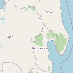
Map view of Ambatovaky Special Reserve

Use this park location map to pinpoint Ambatovaky Special Reserve in Madagascar, understand its exact geographic position, and read its mapped placement within the surrounding landscape more clearly.

Pigeon | © OpenStreetMap contributors

Location context for Ambatovaky Special Reserve

Analanjirofo
Park atlas

Discover regional forest reserves and connected landscapes across northeastern Madagascar

Explore Protected Areas and Parks Near Réserve spéciale d'Ambatovaky

Compare Réserve spéciale d'Ambatovaky with adjacent rainforest reserves and protected areas located throughout the surrounding region. Review neighboring forest habitats and examine regional conservation networks across the eastern escarpment.
National parkMadagascar
About 65 km away#1 closest

East

Mananara Nord National Park: National Park Geography and Protected Landscape Identity

Explore its mapped boundaries within Madagascar's diverse geography.

Mananara Nord National Park represents a vital protected landscape within Madagascar, offering users a direct entry point for exploring its specific geographic character. As a designated national park, it contributes significantly to the atlas of conservation lands on the island nation. This park provides a focused lens through which to examine regional geography and the mapped extent of protected natural areas, anchoring its identity within the broader context of Madagascar's unique ecological landscape.

National parkMadagascar
About 76 km away#2 closest

Northeast

Makira Natural Park: Exploring the Geography and Forested Terrain of Northeastern Madagascar

A vital protected landscape in the humid northeastern forest belt.

Makira Natural Park serves as a benchmark for integrated tropical conservation in Madagascar. Its humid evergreen forests provide a critical habitat for high lemur diversity and specialized botanical associations linked to unique geological substrates. This protected area connects to a larger regional landscape of community-managed forests, acting as a crucial buffer for the biodiversity of the northeastern coastal regions.

Area
3,724.7 km²
Established
2012
IUCN
II
Relief
Mountain
National parkAmbatosoa
About 85 km away#3 closest

Northeast

Nosy Mangabe National Park: Atlas Overview of the Ambatosoa Island Forest Reserve

Coastal rainforests and protected lemur habitats in Antongil Bay.

Nosy Mangabe stands as a prominent protected island within the Ambatosoa region of Madagascar. The island is defined by its dense lowland rainforest, dramatic bay topography, and its essential role as a sanctuary for rare primates. This overview maps the park boundary and explores the terrain, historical maritime traces, and the connection between the island and the Masoala peninsula ecosystem.

Area
90.47 km²
Established
1965
IUCN
II
Visitors
3K annual
National parkSava Region
About 89 km away#4 closest

Northeast

Masoala National Park: Explore Madagascar's Largest Protected Landscape and Marine Ecosystems

Discover the unique geographic features and rich biodiversity of this Sava Region national park.

Masoala National Park represents a critical protected landscape in Madagascar's Sava Region, spanning the vast Masoala Peninsula. The park's protected territory covers a remarkable range of ecosystems, including lowland and montane rainforests, coastal habitats, and extensive marine areas with coral reefs. Understanding the geographic scope and ecological diversity of Masoala National Park provides essential context for appreciating Madagascar's unique natural heritage and the importance of its conservation efforts.

Area
2,400 km²
Established
1997
IUCN
II
Visitors
3K annual
Wildlife reserveSofia region
About 102 km away#5 closest

West

Tampoketsa Analamaitso Reserve: Wildlife Reserve and Protected Forest Geography in Sofia Region

Ecological transition zone featuring humid and dry forest biomes

Tampoketsa Analamaitso Reserve provides a protected sanctuary for northern Madagascar's primate fauna, defined by its rare combination of humid mid-altitude and dense dry forest ecosystems. Managed for habitat conservation, the reserve remains a remote wilderness area with intact forest cover that stretches across the Sofia region. Its geographic importance lies in the ecological gradient that links distinct upland and lowland vegetation types, offering a comprehensive look at the island's diverse natural terrain.

Area
171.5 km²
Established
1958
IUCN
IV
Relief
Upland
Wildlife reserveSava
About 147 km away#6 closest

North

Réserve spéciale d'Anjanaharibe-Sud: Geography and Protected Area Landscape Overview

Deep forest terrain and mountain ridges in the Sava region

Situated in northeastern Madagascar, Réserve spéciale d'Anjanaharibe-Sud encompasses dense evergreen forests and steep mountain terrain. This protected area serves as a significant conservation landscape for rare endemic species, providing a high-elevation habitat that climbs dramatically from 500 meters to peaks above 2,000 meters across the Sava region.

Area
182.56 km²
Established
1958
IUCN
IV
Relief
Mountain
Protected landscapeAlaotra-Mangoro
About 181 km away#7 closest

Southwest

Lake Alaotra Protected Landscape: Atlas and Geographic Wetland Profile

Mapping the primary wetland basin of Madagascar's Alaotra-Mangoro region.

Lake Alaotra serves as a central protected landscape within the Alaotra-Mangoro region, featuring an extensive system of marshes, reedbeds, and freshwater zones. This profile offers a structured look at the lake's geography, its role as a critical wetland habitat, and the surrounding terrain that shapes this important Madagascar catchment area.

Area
7,223 km²
Relief
Lowland
Scope
Terrestrial
Water
Water-dominated
Watercolor painting of a mountainous landscape with green vegetation, a body of water, and distant peaks under a light sky
National parkMadagascar
About 181 km away#8 closest

North

Marojejy National Park: A Protected National Park within Madagascar's Unique Geography

Mapped landscape context and regional protected area significance.

Marojejy National Park is a distinct protected area offering rich insights into Madagascar's natural geography. As a national park, its mapped boundaries define a significant landscape that contributes to the island nation's reputation as a biodiversity hotspot. This entry provides essential context for understanding Marojejy National Park's role within the country's protected lands and its value for structured geographic atlas exploration.

Area
555 km²
Established
1998
IUCN
II
Relief
Mountain

Common questions about visiting, size, designation, and location context for Ambatovaky Special Reserve

Ambatovaky Special Reserve FAQs for park facts, access, geography, and protected area context

Find quick answers about Ambatovaky Special Reserve, including protected-area facts, park geography, trail and visitor context, and how the park fits into its surrounding country and regional landscape.
MoriAtlas Explorer

Continue Your Protected Areas Search Across the Global Atlas

Deepen your exploration by continuing the structured search for national parks and protected areas worldwide. Utilize the comprehensive filtering capabilities to compare different conservation landscapes and refine your understanding of global park geography. Discover more about the distribution and characteristics of protected natural areas.

Global natural geography