

Mori Atlas logo
Natural monumentAnalavelona

A rare subhumid ecological island rising from the semi-arid peneplain of southwestern Madagascar

Analavelona Natural Monument: Mapping the Montane Forest Massif in the Atsimo-Andrefana Region

(Monument Naturel de la Forêt Sacrée Alandraza Analavelo)

Analavelona Natural Monument forms a distinct ecological outlier in southwestern Madagascar, rising as a mountain massif to 1,325 meters above the surrounding dry peneplain. This protected area acts as a crucial refuge for subhumid montane forest, creating a mosaic of evergreen habitats, xerophilous brushland, and grasslands. The site functions as a vital water source for the region, while its isolation fosters unique biodiversity and endemism distinct from the wider Atsimo-Andrefana territory.

montane forestsubhumid forestsacred forestendemic speciesMadagascar biodiversitybiodiversity hotspot

Analavelona

Natural monument

Park overview

Structured park overview, official facts, and landscape profile for Analavelona

Analavelona park facts, protected area profile, and essential visitor context

Review the core facts for Analavelona, including designation, size, terrain, visitor scale, habitats, and operating context in one park-focused overview.

About Analavelona

Analavelona is a prominent forested massif in southwestern Madagascar, located in the Sakaraha District of the Atsimo-Andrefana region. Although it lies within a region dominated by dry lowlands and succulent woodlands, the mountain rises high enough to intercept orographic moisture from the southeast, allowing a distinctive enclave of subhumid forest to survive far from the central highland forests that constitute the main range of this ecosystem in Madagascar. The massif extends in a generally northeast to southwest orientation, with steep slopes cut by streams and a highest peak of about 1,325 meters on Mitsinjoriake.

Ecologically, Analavelona is one of the most important forest refuges in southwestern Madagascar. Its isolation, around 100 kilometers from the nearest comparable subhumid forests on the Isalo Massif, has allowed the development of local endemism. The forests here harbor plant species such as Spondias tefyi and Dalbergia hirticalyx that have very limited ranges, as well as endemic invertebrates like the Analavelona wood-millipede and the Analavelona giant pill-millipede. The massif is also an important site for birds and lemurs characteristic of Madagascar's western and southwestern forests.

Beyond its biodiversity, Analavelona carries strong cultural significance. The Bara people consider the forest, known locally as Alandraza Analavelo, to be sacred, and it plays an important role in local livelihoods as a source of timber, food, and other forest products. A community-based forest management program, supported by the Missouri Botanical Garden's Madagascar Conservation Program, has been active in the area for more than a decade. In 2015 the forest was officially designated by the Government of Madagascar as a natural monument, and it has also been proposed as a national park, reflecting both its ecological value and its cultural importance.

Quick facts and research context for Analavelona

Analavelona is a mountain massif in the Atsimo-Andrefana region of southwestern Madagascar, within the Sakaraha District and roughly northwest of the town of Sakaraha. It extends in a general northeast to southwest direction, with its highest peak, Mitsinjoriake, reaching about 1,325 meters in elevation. The massif rises above a surrounding arid peneplain and receives more orographic precipitation than the lowlands around it, which is what allows subhumid forest to persist there.

The forested area, around 44.87 square kilometers, was designated a natural monument by decree in April 2015 under the name Monument Naturel de la Forêt Sacrée Alandraza Analavelo. It is also proposed as a national park. The forest is considered sacred by the local Bara people and has been managed through a community-based program supported by the Missouri Botanical Garden.

Protection and recognition

Review official designation milestones and terrestrial management scope records

Analavelona Protection Status and Documented Conservation History

Analavelona brings together documented protection status, designation history, and management scope metrics established in 2015. Terrestrial conservation records outline the official framework governing this protected area within the regional landscape.

Protection details

Protection scope
Terrestrial
Designated year
2015
Transboundary protection
No
Park context

Deeper park guide and search-rich context for Analavelona

Analavelona history, landscape, wildlife, and travel context

Explore Analavelona through its history, landscape character, ecosystems, wildlife, conservation priorities, cultural context, and seasonal travel timing in a structured park guide built for atlas discovery and search intent.

Why Analavelona stands out

Analavelona is best known for its isolated patch of subhumid montane forest set within an otherwise dry region of southwestern Madagascar. This ecological outlier supports several endemic species, including plants and invertebrates found nowhere else and birds such as Appert's tetraka, which has only one other known population in the nearby Zombitse forests. The massif is also notable as a sacred forest of the Bara people, combining high biodiversity with strong cultural significance. Its mosaic of humid evergreen forest, sclerophyllous montane forest, xerophilous brushland, and grassland on a single elevated landform makes it a compact but unusually diverse ecological island in the southwest.

Analavelona history and protected-area timeline

The forests of Analavelona have long held cultural significance for the local Bara people, who regard the forest, called Alandraza Analavelo, as sacred and draw on it for timber, food, and other forest products. This traditional relationship laid the foundation for later formal protection efforts grounded in community stewardship rather than strict exclusion.

Modern conservation history began with the forest being designated a classified forest by the Government of Madagascar. Over more than a decade, a community-based management program assisted by the Missouri Botanical Garden's Madagascar Conservation Program has worked to protect and manage the forest in collaboration with local communities.

A formal milestone came on 28 April 2015, when Decree No. 2015-766 officially designated the area as a natural monument under the name Monument Naturel de la Forêt Sacrée Alandraza Analavelo, covering around 44.87 square kilometers. The site has also been proposed as a national park, indicating its recognition as a candidate for higher-level protected-area status in Madagascar's system.

Analavelona landscape and geographic character

Analavelona is a compact mountain massif oriented generally northeast to southwest, rising from a mostly arid peneplain in southwestern Madagascar. Its slopes are steep and incised by stream valleys, with the highest point, Mitsinjoriake, reaching about 1,325 meters. The southeastern flank receives more orographic precipitation than the surrounding lowlands, and this rainfall contrast is central to the massif's ecological character.

The surrounding lowland landscape is dominated by semi-arid conditions, with the massif itself forming a clear ecological and visual boundary against the drier peneplain. Rivers that drain the mountain, including the Fiherenana in the southeast, originate from springs on Analavelona's slopes. Within the massif, terrain varies from densely forested valleys to rocky slopes supporting xerophilous vegetation and open plateau areas with sclerophyllous forest, producing a varied topography within a relatively small geographic footprint.

Analavelona ecosystems, habitats, and plant life

The natural environment of Analavelona is defined by an unusually compressed mosaic of vegetation types. On the lower slopes, dense humid evergreen forest rises in tall, stratified stands with canopy trees such as Uapaca and Dalbergia, abundant lianas, and strangler figs. On the plateau and upper slopes, this grades into drier, sclerophyllous montane forest with a more open understory, while rocky slopes support xerophilous brushland featuring Dracaena and Aloe species. Grasslands punctuate the forest and brushland, creating a patchwork shaped by elevation, soil, and microclimate.

Ecologically, Analavelona is a southwestern outlier of Madagascar's central highland subhumid forests, surrounded at lower elevations by Madagascar succulent woodlands typical of the region. Its nearest ecological counterparts are the forests of the Isalo Massif roughly 100 kilometers to the east. The combination of varied elevation, localized rainfall, and isolation from other subhumid forest patches has produced distinct plant communities, including notable stands of large Dalbergia trees and rare species such as Spondias tefyi, which is shared only with the Zombitse forests to the southeast. Several plants, including Aloe analavelonensis, Euphorbia analavelonensis, and Pseudodicliptera humilis, are endemic to the massif.

Analavelona wildlife and species highlights

Analavelona supports a wildlife community that reflects both its subhumid forest character and its southwestern Malagasy setting. Birdlife includes species typical of Madagascar's humid forests, such as the green jery, forest fody, and spectacled tetraka, alongside Appert's tetraka, a species known from only two sites in the world: Analavelona and the nearby Zombitse forests.

The massif is also an important site for lemurs and other native mammals. Verreaux's sifaka, the ring-tailed lemur, the Zombitse sportive lemur, the pale fork-marked lemur, and the red-fronted brown lemur all occur in the forests, alongside the fossa, Madagascar's largest native carnivore. Among invertebrates, the Analavelona wood-millipede and the Analavelona giant pill-millipede are endemic to the massif, contributing to its profile as a site of narrow-range endemism.

Analavelona conservation status and protection priorities

Analavelona is one of the most important forest conservation sites in southwestern Madagascar because it preserves a relict subhumid forest landscape surrounded by much drier vegetation types. Its geographic isolation from other subhumid forest patches has allowed the persistence of species with very limited ranges, giving the site high value for biodiversity conservation in a region where dryland habitats are dominant.

Community-based management has been central to the site's conservation for more than a decade, with the Missouri Botanical Garden's Madagascar Conservation Program supporting local stewardship efforts. In 2015, the Government of Madagascar strengthened this protection by designating the area as a natural monument through Decree No. 2015-766, legally recognizing both its ecological importance and its status as the sacred Alandraza Analavelo forest of the Bara people. The site has also been proposed as a national park, signaling recognition of its potential role within Madagascar's national protected-area network.

Analavelona cultural meaning and human context

Analavelona holds significant cultural meaning for the Bara people of southwestern Madagascar, who consider the forest known as Alandraza Analavelo to be sacred. The forest is woven into local social and spiritual life and also serves practical roles as a source of timber, food, and other forest products that support everyday livelihoods.

This cultural relationship has shaped conservation at Analavelona. Rather than relying solely on government enforcement, protection efforts have been built around community-based management, reflecting the forest's importance as both a sacred landscape and a living resource. The 2015 designation of the site as a natural monument explicitly incorporates this cultural identity into its protected status.

Top sights and standout views in Analavelona

Analavelona is distinguished by the unusual combination of a subhumid montane forest rising out of an arid southwestern Malagasy landscape, a mosaic of humid evergreen, sclerophyllous, and xerophilous vegetation on a single massif, and a high level of narrow-range endemism in both plants and invertebrates. Its presence as a sacred forest of the Bara people adds a strong cultural dimension to its biodiversity value.

The site is also notable for being one of only two known locations of Appert's tetraka, a globally rare bird, and for serving as a refugium for lemur species characteristic of Madagascar's western and southwestern forests, all within a relatively compact protected area.

Best time to visit Analavelona

The climate of Analavelona is shaped by its position in southwestern Madagascar, where conditions are generally drier than in the central highlands. The southeastern slopes of the massif receive more rainfall than the surrounding peneplain, and visits during or shortly after the wetter months are likely to offer the greenest forest conditions and the most active birdlife and lemur viewing. The dry season, by contrast, may offer clearer views from the surrounding lowlands but reduced forest vitality. Travelers interested in the site's biodiversity will generally find cooler, moister conditions at higher elevations on the massif to be more rewarding than the warmer surrounding lowlands.

Monthly climate preview

Long-term representative averages tracking annual weather rhythms across the protected terrain

Analavelona Climate Normals, Monthly Temperature and Precipitation Patterns

Analavelona records measured monthly temperatures ranging from cooler mid-year minimums to hotter spring maximums alongside distinct precipitation shifts. Examining the complete twelve-month climate profile provides detailed long-term averages for thorough environmental comparison.
Annual mean23 °C
18 °C26 °C
Jan25°
Feb24°
Mar24°
Apr22°
May20°
Jun19°
Jul18°
Aug20°
Sep23°
Oct25°
Nov26°
Dec26°
Warmest month
November

26.3 °C

Coolest month
July

18.2 °C

Wettest month
January

10 mm/day

Driest month
August

0.3 mm/day

Park location guide

Geography guide, regional context, and park location map for Analavelona

Analavelona park geography, regions, and map view in Madagascar

Understand where Analavelona sits in Madagascar through a broader geographic reading of the surrounding landscape, nearby location context, and its mapped position within the national park landscape.

How Analavelona fits into Madagascar

Madagascar is an island nation in the Indian Ocean, positioned off the southeastern coast of Africa. As the world's fourth-largest island and second-largest island country, it stands out for its exceptional biodiversity, over 90% of its wildlife is endemic, making it one of 17 megadiverse countries. The population is approximately 32 million, with Antananarivo as both the capital and largest city.

Wider geography shaping Analavelona in Madagascar

Madagascar lies in the Indian Ocean off the southeastern coast of Africa, separated from the mainland by the Mozambique Channel. The island is situated approximately 400 km from the African continent. As the world's fourth-largest island, it also includes numerous smaller peripheral islands.

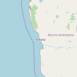
Map view of Analavelona

Use this park location map to pinpoint Analavelona in Madagascar, understand its exact geographic position, and read its mapped placement within the surrounding landscape more clearly.

Pigeon | © OpenStreetMap contributors

Location context for Analavelona

Atsimo-Andrefana
Park atlas

Compare regional protected landscapes and isolated forest habitats across southwestern Madagascar.

Explore Parks Near Analavelona and Surrounding Protected Areas

Browse national parks and protected areas near Analavelona to examine related montane enclaves and arid lowland terrain. Comparing adjacent wilderness areas provides a broader geographic view of southwestern Madagascar conservation zones.
National parkAtsimo-Andrefana
About 54 km away#1 closest

East

Zombitse-Vohibasia National Park: Protected Landscape and Regional Geographic Context

Mapped protected areas and natural terrain discovery.

Investigate Zombitse-Vohibasia National Park, a designated national park within the Atsimo-Andrefana region. This dedicated entry provides detailed geographic information, focusing on the park's mapped terrain and its contribution to the regional protected landscape. Gain insight into the park's atlas-relevant features and its specific place within Madagascar's conservation geography.

Area
363.08 km²
Established
2002
IUCN
II
Relief
Upland
National parkIhorombe Region
About 103 km away#2 closest

East

Isalo National Park: Explore Madagascar's Sandstone Canyons and Protected Landscape Geography

Discover unique geology, tapia woodlands, and regional park context.

Isalo National Park is a prominent protected area in Madagascar's Ihorombe Region, celebrated for its spectacular sandstone landscape. This national park features deep canyons, eroded rock domes, and striking runiform mountains, formed from ancient sedimentary deposits. The park preserves significant tapia woodlands and remarkable plant endemism, offering a rich context for understanding protected land distribution and Madagascar's unique geography. Its mapped terrain provides a visual atlas of natural wonders.

Area
815.4 km²
Established
1962
IUCN
II
Visitors
32.7K annual
Wildlife reserveAtsimo-Andrefana
About 108 km away#3 closest

Southeast

Beza Mahafaly Special Reserve: Atlas of the Gallery Forest and Dry Bush Landscape

Protected riparian ecosystems in the Atsimo-Andrefana region

Beza Mahafaly Special Reserve provides a concentrated look at Madagascar's rare gallery forest ecosystems. Situated within the dry, thorny spiny bush of the Atsimo-Andrefana region, the reserve protects a unique linear woodland environment. Its geography is characterized by the striking contrast between river-fed riparian corridors and the arid, undulating terrain that defines the southwestern landscape.

Area
6 km²
Established
1986
IUCN
IV
Marine protected areaMadagascar
About 122 km away#4 closest

Northwest

Velondriake Marine Protected Area: Coastal Geography and Conservation Landscape in Madagascar

A large-scale community marine reserve in southwestern Madagascar.

Velondriake protects 64,000 hectares of marine and terrestrial environment, spanning coral reefs, extensive mangroves, and inland baobab-rich spiny forests. As a focal point for regional marine management, the area showcases the intersection of coastal ecology and community governance in the western Indian Ocean. Explore the geographic boundaries and habitat features that define this significant marine protected territory along the coast of Madagascar.

Area
640 km²
Established
2006
Relief
Lowland
Climate
Tropical
National parkMadagascar
About 134 km away#5 closest

South

Tsimanampetsotsa National Park: National Park Protected Landscape and Geographic Features

Mapping the protected area boundaries and landscape context.

Delve into the protected landscape identity of Tsimanampetsotsa National Park, a designated national park. This profile focuses on its geographic significance, providing a clear view of its mapped boundaries and the surrounding natural terrain. Understand its role as a protected area within the larger atlas for comprehensive geographic exploration.

Area
432 km²
Established
1927
Relief
Mixed relief
Climate
Arid
National parkAtsimo-Andrefana
About 144 km away#6 closest

South

Tsimanampetsotsa National Park: A Geographic Overview of the Mahafaly Plateau and Spiny Forest

Protected landscapes and wetland geography in Southwestern Madagascar.

Located in the Atsimo-Andrefana region, Tsimanampetsotsa National Park protects a rare convergence of limestone sinkholes, salt-tolerant lake ecosystems, and ancient spiny forest thickets. This atlas record details the park's structural boundaries and its critical role as a site for plant endemism and prehistoric subfossil preservation within the broader Madagascar geographic context.

Area
432 km²
Established
1927
IUCN
II
Relief
Upland
Nature reserveToliara Province
About 214 km away#7 closest

North

Kirindy Forest Nature Reserve: Protected Dry Deciduous Forest in Western Madagascar

Geography, protected boundaries, and unique dry forest ecosystems

Kirindy Forest offers a detailed look into the ecology of western Madagascar. As a protected nature reserve, it shelters three species of baobab trees and diverse primate populations. Its terrain ranges from flat to gently undulating, creating a distinct visual rhythm through alternating dry and rainy seasons within the Menabe region.

Area
125 km²
Relief
Lowland
Climate
Tropical
Access
Moderate access
National parkMadagascar
About 214 km away#8 closest

North

Kirindy Mitea National Park: Madagascar National Park with Distinct Protected Landscape Identity

Explore the mapped geographic context of Kirindy Mitea National Park.

Kirindy Mitea National Park serves as a notable protected area, holding national park status within Madagascar's distinctive island geography. This entry focuses on understanding the park's unique protected landscape and its charted boundaries, offering essential context for atlas-driven exploration. Discover the geographic elements that define Kirindy Mitea National Park and its place within the broader conservation map of the region.

Area
1,563.5 km²
Established
1997
IUCN
IV
Relief
Mixed relief

Common questions about visiting, size, designation, and location context for Analavelona

Analavelona FAQs for park facts, access, geography, and protected area context

Find quick answers about Analavelona, including protected-area facts, park geography, trail and visitor context, and how the park fits into its surrounding country and regional landscape.
MoriAtlas Explorer

Continue Your Protected Areas Search Across the Global Atlas

Deepen your exploration by continuing the structured search for national parks and protected areas worldwide. Utilize the comprehensive filtering capabilities to compare different conservation landscapes and refine your understanding of global park geography. Discover more about the distribution and characteristics of protected natural areas.

Global natural geography