

Mori Atlas logo
Wildlife reserveRéserve spéciale d'Anjanaharibe-Sud

Analyzing the forest terrain and mountain ridges of this essential Madagascar wildlife reserve

Réserve spéciale d'Anjanaharibe-Sud: A Comprehensive Geographic and Protected Area Map Detail

Réserve spéciale d'Anjanaharibe-Sud is a critical protected area in northeastern Madagascar, spanning from mid-elevation humid rainforests to dramatic mountain peaks exceeding 2,000 meters. This reserve, located in the Sava region, sustains an intact forest ecosystem that serves as a vital refuge for endemic primates and a rich community of bird species. Mapping the reserve reveals steep topography and complex river systems that define this essential segment of Madagascar's protected-area network.

humid rainforestprotected forestlemur habitatendemic primatessifaka conservationmountain reserve

Réserve spéciale d'Anjanaharibe-Sud

Wildlife reserve

Park overview

Structured park overview, official facts, and landscape profile for Anjanaharibe-Sud Special Reserve

Anjanaharibe-Sud Special Reserve park facts, protected area profile, and essential visitor context

Review the core facts for Anjanaharibe-Sud Special Reserve, including designation, size, terrain, visitor scale, habitats, and operating context in one park-focused overview.

About Anjanaharibe-Sud Special Reserve

Anjanaharibe-Sud Special Reserve sits in the Sava region of northeastern Madagascar, a landscape defined by steep forested mountains and deeply dissected river valleys. The reserve lies roughly 30 kilometers from Andapa, the nearest town, and forms part of the broader chain of eastern Malagasy protected areas that anchor the island's remaining humid rainforest. Its altitudinal range is one of its defining geographic features, beginning around 500 meters and rising to peaks that exceed 2,000 meters, creating layered habitats from low and mid-elevation forest to montane conditions near the summits.

The reserve's identity is inseparable from its ecological role. It protects a substantial block of dense evergreen humid forest that is unremarkable in the global imagination but extraordinary in its biodiversity value for Madagascar. Two rivers, the Fotsialanana and the Marolakana, both tributaries of the Ankaibe, drain the reserve and maintain the moisture conditions that sustain its forest cover. Together with the better-known Marojejy National Park nearby, Anjanaharibe-Sud anchors one of the most important conservation landscapes on the island for forest-dependent primates.

Though relatively small compared with some of Madagascar's flagship national parks, Anjanaharibe-Sud carries a conservation weight far beyond its footprint. Its inclusion on Madagascar's Tentative List of World Heritage Sites reflects both its ecological integrity and the global recognition of the species it shelters. For visitors, researchers, and conservation partners, the reserve represents a quiet but vital counterpoint to Marojejy, offering additional protection for some of Madagascar's most threatened wildlife within a continuous forest matrix.

Quick facts and research context for Anjanaharibe-Sud Special Reserve

Anjanaharibe-Sud Special Reserve is a forested protected area in the Sava region of northeastern Madagascar, situated roughly 30 kilometers from Andapa. Established in 1958 and classified by IUCN as Category IV, it is administered by Madagascar National Parks and covers approximately 183 square kilometers of mid- to high-elevation humid forest. The reserve is one of only two protected sites in the world where the critically endangered silky sifaka still occurs, making it a key refuge for Madagascar's rare primates and humid-forest biodiversity.

Protection and recognition

Documented terrestrial protection scope, WDPA records, and management parameters

Protection Status and International Recognition for Réserve spéciale d'Anjanaharibe-Sud

Terrestrial protection status data and WDPA records outline the administrative framework for Réserve spéciale d'Anjanaharibe-Sud. Structured conservation parameters provide clear reference metrics regarding management scope and official designation history.

Protection details

Protection scope
Terrestrial
Transboundary protection
No
WDPA ID
5023
Park context

Deeper park guide and search-rich context for Anjanaharibe-Sud Special Reserve

Anjanaharibe-Sud Special Reserve history, landscape, wildlife, and travel context

Explore Anjanaharibe-Sud Special Reserve through its history, landscape character, ecosystems, wildlife, conservation priorities, cultural context, and seasonal travel timing in a structured park guide built for atlas discovery and search intent.

Why Anjanaharibe-Sud Special Reserve stands out

Anjanaharibe-Sud Special Reserve is most famous as one of the last strongholds of the silky sifaka, one of the rarest primates on Earth. Few protected areas in Madagascar carry the same weight for the survival of this species, and the reserve's pairing with Marojejy National Park makes it central to any discussion of silky sifaka conservation. Beyond its primate significance, the reserve is known for its dense, evergreen humid forest that climbs from around 500 meters to peaks above 2,000 meters, creating a continuous gradient of mid-altitude and montane rainforest habitats. This elevational range, combined with two perennial river systems, supports unusually rich biodiversity including the indri, aye-aye, red-bellied lemurs, and over 112 recorded bird species.

Anjanaharibe-Sud Special Reserve history and protected-area timeline

The Anjanaharibe-Sud Special Reserve was formally established in 1958 as one of the early protected areas of independent-era Madagascar, with the explicit purpose of preserving the surrounding humid forests and the wildlife they supported. Its designation predates the broader post-2003 restructuring of Madagascar's protected-area network and reflects an early recognition that the steep forested mountains north of Andapa deserved formal protection.

Today the reserve is administered by Madagascar National Parks, the national institution that manages Madagascar's flagship parks and reserves. Its inclusion on Madagascar's Tentative List of World Heritage Sites in 2008 further acknowledged its broader significance, particularly in relation to the criteria of ecological importance and biodiversity. Local stewardship efforts, including groups such as the Friends of the Anjanaharibe-Sud Special Reserve, have also contributed to the ongoing management and visibility of the protected area.

Anjanaharibe-Sud Special Reserve landscape and geographic character

The landscape of Anjanaharibe-Sud is built around the abrupt topography that characterizes northeastern Madagascar. From a base near 500 meters elevation, the terrain climbs sharply toward forested ridgelines and rocky peaks that reach beyond 2,000 meters, producing dramatic elevational relief over relatively short horizontal distances. This gradient creates a layered scenery of dense forest cover, deep valleys, and increasingly montane character at higher altitudes.

Hydrology plays an important role in shaping the reserve. The Fotsialanana and Marolakana rivers cut through the protected area as tributaries of the Ankaibe River, carving valleys into the slopes and sustaining the moisture conditions that the forest depends on. The result is a continuously forested terrain where steep hillsides, narrow valleys, and high crests blend into a single, unbroken green landscape, with little human disturbance visible across much of the reserve.

Anjanaharibe-Sud Special Reserve ecosystems, habitats, and plant life

Anjanaharibe-Sud protects a classic example of Madagascar's eastern humid rainforest, specifically a dense evergreen forest of mid-elevation character that extends upward into montane conditions at higher altitudes. The forest type, classified as dense humid evergreen sempervirent forest, is one of the most species-rich and threatened ecosystems on the island. Its continuity across the reserve helps maintain the humidity, microclimate, and habitat structure on which the area's primates and birds depend.

The elevational gradient and river systems combine to support a high diversity of ecological niches within a relatively small area. Lower slopes, mid-elevation valleys, and upper montane zones each contribute distinct vegetation and habitat conditions, while the rivers keep the understory and canopy consistently moist. This ecological layering is central to why a modest-sized reserve can sustain such a remarkable concentration of endemic species.

Anjanaharibe-Sud Special Reserve wildlife and species highlights

The reserve's wildlife profile is dominated by its primates, which include some of the rarest lemurs on Earth. It is one of only two protected areas, alongside Marojejy National Park, where the silky sifaka still survives, a species so restricted in range that its conservation status is treated as critical worldwide. The reserve also supports the indri, known for its haunting morning calls echoing through eastern Malagasy forests, as well as the unusual and nocturnal aye-aye and red-bellied lemurs.

Birdlife is similarly rich. More than 112 species have been recorded in the reserve, drawing on Madagascar's extraordinary endemic avifauna. Notable species include the Madagascar grebe, the Madagascar serpent eagle, the Madagascar rail, and the monias, a distinctive ground-dwelling mesite endemic to the island. Together with the primate fauna, this bird community reinforces the reserve's status as a key component of Madagascar's eastern rainforest biodiversity network.

Anjanaharibe-Sud Special Reserve conservation status and protection priorities

Anjanaharibe-Sud holds conservation significance that far exceeds the modest scale of its boundaries. As one of only two protected areas for the silky sifaka, it is a last-line refuge for a primate that exists nowhere else in the world, and its survival as a habitat is closely tied to the long-term prospects of the species. The reserve's dense humid forest also serves as carbon storage, watershed protection, and a buffer against fragmentation in a region where remaining forest blocks are increasingly isolated.

The reserve's formal recognition has grown over time. It is classified as a Category IV protected area under IUCN guidelines, and in 2008 it was added to Madagascar's Tentative List of World Heritage Sites under criteria related to ecological processes and biodiversity. Its management under Madagascar National Parks and the involvement of local conservation groups reflect a layered approach to stewardship, linking national institutional oversight with community-rooted protection efforts in one of the country's most ecologically sensitive regions.

Top sights and standout views in Anjanaharibe-Sud Special Reserve

Anjanaharibe-Sud draws its global significance from a single overriding reality: it is one of the last two refuges of the silky sifaka, one of the rarest primates on Earth. This alone sets the reserve apart, but its dense evergreen humid forest, its sharp rise from around 500 meters to peaks above 2,000 meters, and its position alongside Marojejy National Park make it a cornerstone of primate conservation in Madagascar.

Equally important are its quieter distinctions: a bird community of more than 112 species, including the Madagascar serpent eagle and monias; rivers such as the Fotsialanana and Marolakana that sustain the forest; and inclusion on Madagascar's Tentative List of World Heritage Sites. For travelers and researchers drawn to Madagascar's eastern rainforests, Anjanaharibe-Sud represents both a critical conservation site and a deeply forested mountain landscape of rare ecological integrity.

Best time to visit Anjanaharibe-Sud Special Reserve

Like much of northeastern Madagascar, Anjanaharibe-Sud is best experienced during the drier months, when forest trails are more manageable and wildlife observation, particularly of lemurs, tends to be more rewarding. The wetter periods make the humid forest even denser and more atmospheric, but they also bring heavier rainfall, slicker trails, and more challenging conditions for travel and primate tracking.

Cooler temperatures associated with higher elevations and the dry season also tend to make continuous forest exploration more comfortable, especially when moving between mid-altitude and montane zones. The reserve's evergreen forest retains its character year-round, so the seasonal contrast is less about dramatic landscape transformation and more about access, weather, and the ease of encounters with the reserve's rare wildlife.

Monthly climate preview

Long-term representative temperature and precipitation averages across twelve months

Réserve spéciale d'Anjanaharibe-Sud Climate Normals and Monthly Weather Patterns

Representative coordinates track measured monthly temperature ranges alongside daily precipitation averages from 1991 to 2020 at an elevation of 1045 meters. Reviewing the complete twelve-month profile reveals detailed long-term climatic shifts across the protected landscape.
Annual mean18 °C
15 °C21 °C
Jan21°
Feb21°
Mar20°
Apr19°
May18°
Jun16°
Jul15°
Aug15°
Sep16°
Oct18°
Nov19°
Dec20°
Warmest month
February

20.7 °C

Coolest month
July

15.1 °C

Wettest month
January

14.3 mm/day

Driest month
October

3.4 mm/day

Park location guide

Geography guide, regional context, and park location map for Anjanaharibe-Sud Special Reserve

Anjanaharibe-Sud Special Reserve park geography, regions, and map view in Madagascar

Understand where Anjanaharibe-Sud Special Reserve sits in Madagascar through a broader geographic reading of the surrounding landscape, nearby location context, and its mapped position within the national park landscape.

How Anjanaharibe-Sud Special Reserve fits into Madagascar

Madagascar is an island nation in the Indian Ocean, positioned off the southeastern coast of Africa. As the world's fourth-largest island and second-largest island country, it stands out for its exceptional biodiversity, over 90% of its wildlife is endemic, making it one of 17 megadiverse countries. The population is approximately 32 million, with Antananarivo as both the capital and largest city.

Wider geography shaping Anjanaharibe-Sud Special Reserve in Madagascar

Madagascar lies in the Indian Ocean off the southeastern coast of Africa, separated from the mainland by the Mozambique Channel. The island is situated approximately 400 km from the African continent. As the world's fourth-largest island, it also includes numerous smaller peripheral islands.

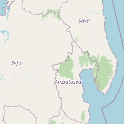
Map view of Anjanaharibe-Sud Special Reserve

Use this park location map to pinpoint Anjanaharibe-Sud Special Reserve in Madagascar, understand its exact geographic position, and read its mapped placement within the surrounding landscape more clearly.

Pigeon | © OpenStreetMap contributors

Location context for Anjanaharibe-Sud Special Reserve

Sava
Park atlas

Compare adjacent rainforest reserves and connected mountain habitats in northeastern Madagascar

Explore Parks Near Réserve spéciale d'Anjanaharibe-Sud and Surrounding Protected Landscapes

Browsing other protected areas near Réserve spéciale d'Anjanaharibe-Sud reveals connected mountain terrain and humid rainforest corridors across northeastern Madagascar. Comparing regional reserves helps place rare primate habitats and steep elevational gradients into a broader conservation context.
Watercolor painting of a mountainous landscape with green vegetation, a body of water, and distant peaks under a light sky
National parkMadagascar
About 40 km away#1 closest

Northeast

Marojejy National Park: A Protected National Park within Madagascar's Unique Geography

Mapped landscape context and regional protected area significance.

Marojejy National Park is a distinct protected area offering rich insights into Madagascar's natural geography. As a national park, its mapped boundaries define a significant landscape that contributes to the island nation's reputation as a biodiversity hotspot. This entry provides essential context for understanding Marojejy National Park's role within the country's protected lands and its value for structured geographic atlas exploration.

Area
555 km²
Established
1998
IUCN
II
Relief
Mountain
National parkSava Region
About 79 km away#2 closest

Southeast

Masoala National Park: Explore Madagascar's Largest Protected Landscape and Marine Ecosystems

Discover the unique geographic features and rich biodiversity of this Sava Region national park.

Masoala National Park represents a critical protected landscape in Madagascar's Sava Region, spanning the vast Masoala Peninsula. The park's protected territory covers a remarkable range of ecosystems, including lowland and montane rainforests, coastal habitats, and extensive marine areas with coral reefs. Understanding the geographic scope and ecological diversity of Masoala National Park provides essential context for appreciating Madagascar's unique natural heritage and the importance of its conservation efforts.

Area
2,400 km²
Established
1997
IUCN
II
Visitors
3K annual
National parkMadagascar
About 80 km away#3 closest

South

Makira Natural Park: Exploring the Geography and Forested Terrain of Northeastern Madagascar

A vital protected landscape in the humid northeastern forest belt.

Makira Natural Park serves as a benchmark for integrated tropical conservation in Madagascar. Its humid evergreen forests provide a critical habitat for high lemur diversity and specialized botanical associations linked to unique geological substrates. This protected area connects to a larger regional landscape of community-managed forests, acting as a crucial buffer for the biodiversity of the northeastern coastal regions.

Area
3,724.7 km²
Established
2012
IUCN
II
Relief
Mountain
National parkAmbatosoa
About 96 km away#4 closest

South

Nosy Mangabe National Park: Atlas Overview of the Ambatosoa Island Forest Reserve

Coastal rainforests and protected lemur habitats in Antongil Bay.

Nosy Mangabe stands as a prominent protected island within the Ambatosoa region of Madagascar. The island is defined by its dense lowland rainforest, dramatic bay topography, and its essential role as a sanctuary for rare primates. This overview maps the park boundary and explores the terrain, historical maritime traces, and the connection between the island and the Masoala peninsula ecosystem.

Area
90.47 km²
Established
1965
IUCN
II
Visitors
3K annual
Nature reserveDiana
About 103 km away#5 closest

Northwest

Réserve naturelle intégrale de Tsaratanana: Highland Massif and Protected Mountain Terrain

High-altitude geography in the Diana region of northern Madagascar

Spanning tens of thousands of hectares, the Réserve naturelle intégrale de Tsaratanana protects the highest mountain terrain in Madagascar. The landscape is defined by the crystalline Vohibory massif, creating a complex topography of deep valleys and dramatic elevation gradients that support endemic primate habitats and montane forest ecosystems.

Area
486.22 km²
Established
1927
IUCN
Ia
Wildlife reserveDiana
About 140 km away#6 closest

Northwest

Manongarivo Special Reserve: Protected Wildlife and River Landscapes in Northern Madagascar

Examining the humid forest terrain and geographic boundaries of the Diana region

Located in the Diana region, Manongarivo Special Reserve serves as a critical protected area within the northern humid rainforest system of Madagascar. The territory is defined by steep forested hills, narrow river valleys, and diverse ecological niches. By analyzing its specific topographic markers and river systems, this entry details the natural landscape and protected status of this significant biodiversity reserve.

Area
327.35 km²
Established
1956
IUCN
IV
Climate
Tropical
Wildlife reserveAnalanjirofo
About 147 km away#7 closest

South

Réserve spéciale d'Ambatovaky: Protected Forest Landscape and Wildlife Reserve in Analanjirofo

Mapping rugged terrain and endemic forest ecosystems in northeastern Madagascar.

Réserve spéciale d'Ambatovaky spans a challenging, topographically complex area of northeastern Madagascar. This wildlife reserve consists of an unbroken canopy of humid lowland and hill forests, providing a critical refuge for rare raptors and diverse primate communities within the Analanjirofo region's mountainous terrain.

Area
600.5 km²
Established
1958
IUCN
IV
Relief
Upland
National parkMadagascar
About 166 km away#8 closest

South

Mananara Nord National Park: National Park Geography and Protected Landscape Identity

Explore its mapped boundaries within Madagascar's diverse geography.

Mananara Nord National Park represents a vital protected landscape within Madagascar, offering users a direct entry point for exploring its specific geographic character. As a designated national park, it contributes significantly to the atlas of conservation lands on the island nation. This park provides a focused lens through which to examine regional geography and the mapped extent of protected natural areas, anchoring its identity within the broader context of Madagascar's unique ecological landscape.

Common questions about visiting, size, designation, and location context for Anjanaharibe-Sud Special Reserve

Anjanaharibe-Sud Special Reserve FAQs for park facts, access, geography, and protected area context

Find quick answers about Anjanaharibe-Sud Special Reserve, including protected-area facts, park geography, trail and visitor context, and how the park fits into its surrounding country and regional landscape.
MoriAtlas Explorer

Continue Your Protected Areas Search Across the Global Atlas

Deepen your exploration by continuing the structured search for national parks and protected areas worldwide. Utilize the comprehensive filtering capabilities to compare different conservation landscapes and refine your understanding of global park geography. Discover more about the distribution and characteristics of protected natural areas.

Global natural geography