Mori Atlas logo
Protected landscapeArapaho National Recreation Area

High-altitude reservoir networks and mountain forest terrain within the Grand County region

Arapaho National Recreation Area: Mapping Protected Landscapes and Colorado River Headwaters

Arapaho National Recreation Area encompasses a significant expanse of water-rich terrain in north central Colorado, centered on the Great Lakes of Colorado. Situated at the headwaters of the Colorado River and adjacent to Rocky Mountain National Park, this protected landscape features an extensive network of reservoirs and alpine forest environments. Mapped boundaries showcase the transition from the upper Colorado River valley to the rugged slopes of the Arapaho and Roosevelt National Forests, offering deep insight into the region's mountain geography and watershed connectivity.

national recreation areamountain lakesreservoirsColorado headwatersRocky Mountain gatewayContinental Divide trail

Arapaho National Recreation Area

Protected landscape

Park overview

Structured park overview, official facts, and landscape profile for Arapaho National Recreation Area

Arapaho National Recreation Area park facts, protected area profile, and essential visitor context

Review the core facts for Arapaho National Recreation Area, including designation, size, terrain, visitor scale, habitats, and operating context in one park-focused overview.

About Arapaho National Recreation Area

Arapaho National Recreation Area is a federally designated national recreation area in north central Colorado, occupying a strategic position near the headwaters of the Colorado River. The recreation area lies in Grand County, with the nearest town being Granby, and sits directly adjacent to Rocky Mountain National Park on its western flank. ANRA is administered by the United States Forest Service as a unit of the Arapaho and Roosevelt National Forests, placing it within one of the most heavily visited forested landscapes in the Colorado Rockies.

The defining feature of ANRA is its series of lakes in the upper Colorado River valley. Lake Granby, Shadow Mountain Lake, Willow Creek Reservoir, Monarch Lake, and Meadow Creek Reservoir form the core of the recreation area, while Grand Lake, the largest natural lake in Colorado, borders the area to the north and is closely associated with the ANRA experience. Together these six lakes are popularly referred to as the Great Lakes of Colorado, a designation that captures both the geography and the recreational identity of the region.

Beyond its water bodies, ANRA encompasses forested ridges, meadows, and shoreline terrain typical of the Colorado high country. Its elevation range, pine and aspen forests, and the riverine environment of the upper Colorado River give it a landscape character that blends montane and subalpine elements. The recreation area provides extensive shoreline for camping, boating, and fishing, while also supporting hiking and trail-based activities.

The recreation area's relationship to Rocky Mountain National Park is central to its profile. ANRA effectively serves as a western gateway complement to the park, offering developed lakeside recreation, reservoir-based activities, and national forest trails that connect to the broader Rocky Mountains ecosystem. The Continental Divide National Scenic Trail passes through the area, reinforcing ANRA's place within the larger network of long-distance trails that traverse the Continental Divide in Colorado. Established in 1978, ANRA remains one of the more compact yet recreation-intensive units of the National Forest System in the state.

Quick facts and research context for Arapaho National Recreation Area

Arapaho National Recreation Area is located in Grand County, Colorado, near the town of Granby and immediately west of Rocky Mountain National Park. It encompasses roughly 30,690 acres and was established in 1978 as a national recreation area managed by the United States Forest Service within the Arapaho and Roosevelt National Forests.

The recreation area is defined by its cluster of lakes and reservoirs in the upper Colorado River valley, including both large man-made reservoirs and smaller natural lakes. It is crossed by the Continental Divide National Scenic Trail and serves as a major focal point for boating, camping, and shoreline recreation in north central Colorado.

Protection and recognition

Analysis of terrestrial protected area designation and management parameters

Arapaho National Recreation Area Protection Status and Documented Conservation Scope

Terrestrial conservation frameworks establish the baseline protection status and management scope for Arapaho National Recreation Area. Documented designation metrics outline the administrative boundaries and official recognition parameters governing the protected landscape.

Protection details

Protection scope
Terrestrial
Transboundary protection
No
Park context

Deeper park guide and search-rich context for Arapaho National Recreation Area

Arapaho National Recreation Area history, landscape, wildlife, and travel context

Explore Arapaho National Recreation Area through its history, landscape character, ecosystems, wildlife, conservation priorities, cultural context, and seasonal travel timing in a structured park guide built for atlas discovery and search intent.

Why Arapaho National Recreation Area stands out

Arapaho National Recreation Area is best known as the heart of the Great Lakes of Colorado, a cluster of high-country reservoirs and lakes clustered around the headwaters of the Colorado River. The grouping of Lake Granby, Shadow Mountain Lake, Willow Creek Reservoir, Monarch Lake, and Meadow Creek Reservoir, combined with adjacent Grand Lake, gives the recreation area an unusual concentration of large water bodies for a mountain setting. Its location directly beside Rocky Mountain National Park, its management within the Arapaho and Roosevelt National Forests, and the passage of the Continental Divide National Scenic Trail through the area further define its identity as a mountain recreation and water-based outdoor destination.
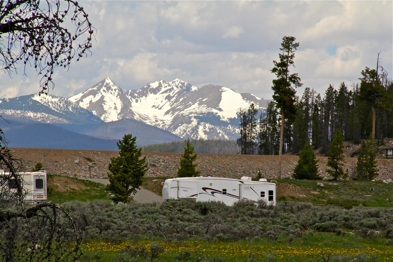
A white recreational vehicle sits in a campground area with sagebrush and pine trees, set against a backdrop of distant, snow-covered mountains.
A recreational vehicle parked at Green Ridge Campground, with snow-capped mountain peaks in the background.

Arapaho National Recreation Area history and protected-area timeline

Arapaho National Recreation Area was established in 1978 as a United States national recreation area, formalizing federal recognition of the upper Colorado River valley's exceptional value for outdoor recreation. Its creation reflected a broader period in which national recreation area designations were used to protect and manage highly popular water-based and forested landscapes under the U.S. Forest Service rather than the National Park Service.

The recreation area was built around existing reservoirs and natural lakes that had already become focal points of regional recreation, including Lake Granby and its associated storage system in the Colorado River headwaters. By placing these waters and the surrounding national forest lands under a unified recreation-area designation, the Forest Service sought to provide a coordinated framework for managing the lakes, campgrounds, trails, and shoreline development that had grown around them.

Since its establishment, ANRA has been managed as part of the Arapaho and Roosevelt National Forests. Its continuing role as a recreation hub adjacent to Rocky Mountain National Park has shaped its evolution, with infrastructure and management choices reflecting the steady demand for lakeside camping, boating, and access to the surrounding mountain landscapes.

Arapaho National Recreation Area landscape and geographic character

The landscape of Arapaho National Recreation Area is shaped by the convergence of mountain terrain with a series of large lake basins in the upper Colorado River valley. The area occupies a transitional zone between the lower valley setting around Granby and the higher elevations approaching the Continental Divide, with forested ridges, shoreline meadows, and rolling montane topography framing the reservoirs.

Lake Granby and Shadow Mountain Lake act as the dominant water features of the recreation area, forming broad, reservoir-style shorelines with coves, inlets, and surrounding pine forest. Willow Creek Reservoir, Monarch Lake, and Meadow Creek Reservoir add smaller-scale lake basins set amid denser forest cover, while Grand Lake along the northern boundary contributes a more open, natural lakeshore character just outside the recreation area's formal boundary.

Outside the immediate lakeshore zones, the ANRA landscape includes pine, fir, and aspen woodlands, grassy openings, and the riverine corridor of the upper Colorado River. The terrain provides a mix of gentle shoreline, rolling hills, and steeper forested slopes, creating a setting that combines accessible waterfront with classic Colorado Rocky Mountain scenery.

Arapaho National Recreation Area ecosystems, habitats, and plant life

The natural environment of Arapaho National Recreation Area is defined by the interplay between montane coniferous forest and an unusually high concentration of freshwater lake habitat. The recreation area's forests are characteristic of the Arapaho and Roosevelt National Forests, with lodgepole pine, ponderosa pine, Douglas fir, and aspen stands occupying different elevations and slope conditions throughout the valley.

Wetland and shoreline vegetation patterns are an important ecological feature, with marshy edges, sedge meadows, and riparian growth supporting the transition between open water and forested uplands. The reservoirs and natural lakes create diverse habitat conditions, from shallow, vegetated margins to deeper open water, contributing to the ecological complexity of the upper Colorado River system.

Because the recreation area sits at the headwaters of the Colorado River, its forests, wetlands, and lake margins also form part of a broader watershed context that extends downstream through the Colorado River basin. This positioning gives ANRA ecological significance that extends beyond its boundaries, linking its habitats to the larger Rocky Mountain landscape.

Arapaho National Recreation Area wildlife and species highlights

Wildlife in Arapaho National Recreation Area reflects the rich montane and lakeside habitat of the upper Colorado River valley. The combination of forested uplands, meadow openings, wetlands, and large lake bodies supports a diverse community of mammals, birds, and aquatic species typical of Colorado's high country.

The lakes, particularly Lake Granby, Shadow Mountain Lake, and Grand Lake, are known for trout fishing and other warm- and cold-water fisheries, making fish a central element of the area's recreational and ecological profile. Shoreline and wetland habitats attract waterfowl and wading birds, while the surrounding conifer and aspen forests support songbirds, raptors, and game species such as elk, mule deer, and other ungulates that move between the recreation area and neighboring Rocky Mountain National Park.

Riparian corridors and beaver-modified wetlands further increase habitat variety, supporting small mammals, amphibians, and a range of bird species that depend on water-based environments. The combination of these habitats makes ANRA a productive area for wildlife observation in addition to its more developed recreation uses.

Arapaho National Recreation Area conservation status and protection priorities

From a conservation perspective, Arapaho National Recreation Area plays an important role in protecting a high-value headwaters landscape of the Colorado River. The area's national recreation area designation, together with its placement within the Arapaho and Roosevelt National Forests, has helped preserve a working balance between recreational use and the long-term integrity of forests, lakes, wetlands, and the upper Colorado River watershed.

The recreation area safeguards significant shoreline and forest habitat in a region that has experienced substantial development pressure around Granby and Grand Lake. By keeping large tracts of lakeshore and surrounding national forest in public ownership, ANRA contributes to landscape connectivity with Rocky Mountain National Park, supporting wildlife movement and habitat continuity along the Continental Divide.

The area also has conservation relevance as a reservoir-based water resource within the Colorado River basin. Management of the lakes and surrounding lands takes into account water storage, water quality, and riparian conditions, linking the recreation area's ecological health to downstream water uses and broader regional conservation concerns.

Arapaho National Recreation Area cultural meaning and human context

The region surrounding Arapaho National Recreation Area has long been associated with outdoor recreation traditions in Colorado, with communities such as Granby and Grand Lake developing alongside the reservoirs and natural lakes that define the area. The Great Lakes of Colorado designation reflects the strong local identity that has grown around these water bodies as defining features of Grand County.

The recreation area also carries connections to the broader mountain culture of the Colorado Rockies, including tourism, ranching heritage, and the long history of visitors coming to fish, boat, and camp along the upper Colorado River. Its proximity to Rocky Mountain National Park places it within a corridor that has shaped outdoor recreation in the American West for generations.

Top sights and standout views in Arapaho National Recreation Area

The defining highlights of Arapaho National Recreation Area include the Great Lakes of Colorado cluster, particularly the combined shoreline experience of Lake Granby, Shadow Mountain Lake, and adjacent Grand Lake. These large water bodies in a forested mountain setting are unusual in the Colorado Rockies and form the core identity of the recreation area.

ANRA's direct boundary with Rocky Mountain National Park is a major highlight, placing it within one of the most iconic national park landscapes in the United States. The passage of the Continental Divide National Scenic Trail through the area adds a long-distance trail dimension, while its campgrounds, lakeside access, and national forest setting together make it a versatile outdoor destination in north central Colorado.

Best time to visit Arapaho National Recreation Area

Arapaho National Recreation Area has a strong seasonal character shaped by its high-country climate. Summer is the most active period, when the lakes are fully usable for boating, fishing, and shoreline recreation, the campgrounds are open, and the surrounding forests and trails are most accessible. Warm weather also brings the most developed visitor atmosphere along the reservoirs.

Shoulder seasons, particularly late spring and early fall, can offer quieter conditions and shifting scenery, with changing foliage patterns in the aspen stands and varied wildlife activity around the lakes and meadows. Winter brings snow and cold temperatures that transform the recreation area into a quieter, snow-covered landscape, with icy lake surfaces and snow-based activities replacing the summer water recreation focus. Visitors considering the area should weigh their interest in water-based recreation, trail use, or winter scenery when choosing a season.
Monthly climate preview

Measured annual temperature and precipitation normals for high elevation terrain

Arapaho National Recreation Area Climate and Long Term Weather by Month

Representative coordinates track long term monthly temperature ranges and precipitation rhythms across the protected terrain. Complete twelve month climate records provide detailed baseline measurements for the entire elevation profile.
Annual mean4 °C
-7 °C17 °C
Jan-7°
Feb-7°
Mar-3°
Apr
May
Jun13°
Jul17°
Aug15°
Sep11°
Oct
Nov-2°
Dec-7°
Warmest month
July

16.7 °C

Coolest month
January

-7.3 °C

Wettest month
April

2.2 mm/day

Driest month
December

1 mm/day

Park location guide

Geography guide, regional context, and park location map for Arapaho National Recreation Area

Arapaho National Recreation Area park geography, regions, and map view in United States of America

Understand where Arapaho National Recreation Area sits in United States of America through a broader geographic reading of the surrounding landscape, nearby location context, and its mapped position within the national park landscape.

How Arapaho National Recreation Area fits into United States of America

The United States of America is a federal presidential republic and one of the world's largest countries by area and population. It consists of 50 states across a vast territory spanning multiple time zones, with its capital in Washington, D.C. and largest city in New York City. The nation has a diverse economy, influential political system, and significant cultural and military presence globally.

Wider geography shaping Arapaho National Recreation Area in United States of America

The United States occupies a vast territory in North America, bordered by Canada to the north and Mexico to the south. The 48 contiguous states stretch from the Atlantic to the Pacific Ocean, while Alaska occupies the northwestern region and Hawaii is an archipelago in the Pacific. The country encompasses diverse terrain including the Rocky Mountains, Appalachian Mountains, Great Plains, and extensive river systems.

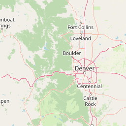
Map view of Arapaho National Recreation Area

Use this park location map to pinpoint Arapaho National Recreation Area in United States of America, understand its exact geographic position, and read its mapped placement within the surrounding landscape more clearly.

Pigeon | © OpenStreetMap contributors

Location context for Arapaho National Recreation Area

ColoradoGrand County
Natural feature types

Browse the Geographic Landscapes of Arapaho National Recreation Area

Deepen your understanding of Arapaho National Recreation Area by exploring the specific natural features and terrain that define its geography. MoriAtlas organizes these landmarks to provide a clear view of the reservoir basins and forested slopes in the Colorado high country.

Visual reference for high-country reservoirs, alpine forests, and lake basins

Arapaho National Recreation Area Photos: Scenery and Mountain Landscapes

Visual documentation captures the high-country reservoirs, forested shorelines, and mountain terrain defining Arapaho National Recreation Area. Detailed photographic views reveal the protected landscape character, alpine habitats, and upper Colorado River valley environments.

A white recreational vehicle sits in a campground area with sagebrush and pine trees, set against a backdrop of distant, snow-covered mountains.

Park atlas

Compare connected protected areas, high country reservoirs, and regional Colorado terrain

Explore Parks Near Arapaho National Recreation Area and Surrounding Mountain Landscapes

Browse nearby national parks and protected areas located throughout the surrounding Colorado high country region. Expanding beyond Arapaho National Recreation Area reveals broader geographic patterns across adjacent alpine forests and watershed valleys.
A watercolor painting of a mountain landscape featuring a small lake, grassy slopes, and conifer trees with a prominent rocky peak in the distance.
Wildlife reserveColorado
Park boundaries overlap#1 closest

East

Indian Peaks Wilderness: Alpine Geography and Front Range Protected Landscapes

Mapping high country summits and glacial basins in Colorado

Indian Peaks Wilderness stands as a signature wildlife reserve along the Colorado Continental Divide. This atlas entry focuses on its complex system of thirteen-thousand-foot peaks, relict glaciers, and interconnected alpine lakes that define the Front Range. Gain insight into the protected boundaries and glacial geomorphology that characterize this high-country landscape near the Denver metropolitan region.

Area
310.44 km²
Established
1978
IUCN
Ib
Relief
Mountain
National parkColorado
Park boundaries overlap#2 closest

North

Rocky Mountain National Park: National Park Protected Landscape in Colorado

Explore its mapped boundaries and regional geographic context.

Rocky Mountain National Park is a designated National Park within Colorado, crucial for understanding the distribution and geographic context of protected areas in the United States. This detail page provides an atlas-oriented perspective, emphasizing the park's mapped boundaries and its place within the natural landscape of the region. It is designed to facilitate a clear understanding of the park's protected status and its contribution to the atlas of natural landscapes, offering factual insights for geographic discovery.

Area
1,074.28 km²
Established
1915
IUCN
II
Visitors
4.2M annual
A horizontal watercolor painting showing a range of purple and reddish-toned mountains in the distance, behind rolling green fields and a pale pinkish waterway in the foreground.
Protected landscapeColorado
1.2 km away#3 closest

North

Roosevelt National Forest: Mapping Wilderness and Protected Landscapes in Northern Colorado

Regional geography, river corridors, and alpine mountain terrain

Roosevelt National Forest encompasses a significant protected landscape across Larimer, Boulder, Gilpin, and Jefferson counties. The forest features a complex terrain of deep canyons, forested plateaus, and protected wilderness areas that form a scenic buffer along the eastern side of the Continental Divide and Rocky Mountain National Park.

Area
3,293.33 km²
Established
1902
Relief
Mountain
Climate
Subpolar
A horizontal watercolor painting showing a soft mountain range in the distance, a midground forest, and a foreground area suggesting marshy ground or a meadow.
Wildlife reserveColorado
7.4 km away#4 closest

North

Never Summer Wilderness: Protected Mountain Geography and Alpine Terrain in Colorado

High-altitude wilderness along the Continental Divide

Spanning over 21,000 acres, the Never Summer Wilderness defines a critical segment of the Colorado Rockies. This protected area features a jagged skyline of 12,000-foot summits, extensive alpine tundra, and the remarkable old-growth spruce and fir forests of Bowen Gulch. Use these maps to understand its role as a vital headwater landscape and its position as a sanctuary for alpine wildlife and ecosystems.

Area
85.3 km²
Established
1980
IUCN
Ib
Relief
Mountain
A watercolor painting showing a panoramic view of mountain peaks in the background behind a forest landscape, set against a white background.
Wildlife reserveColorado
About 16 km away#5 closest

South

James Peak Wilderness: Geographic Profile and Protected Landscape Mapping

High elevation terrain in the Colorado Rockies

James Peak Wilderness provides a critical protected landscape featuring dramatic alpine summits, U-shaped glacial valleys, and subalpine meadows. Its geographic structure forms an essential ecological link along the Colorado Front Range, characterized by high-elevation peaks, dense coniferous forests, and diverse tundra ecosystems situated immediately east of the Continental Divide.

Area
68.86 km²
Established
2002
IUCN
Ib
A watercolor painting showing purple and white mountain peaks rising above green rolling hills and meadows in a wide panoramic format
Protected areaColorado
37 km away#6 closest

South

Mount Evans Wilderness: Alpine Landscapes and Protected Geography in Colorado

Glacial cirques and high-altitude wilderness ecosystems.

Mount Evans Wilderness offers a premier look at the Colorado Front Range, defined by its dramatic relief, sheer cliff lines, and extensive glacial history. This entry examines the wilderness as a protected zone that transitions from montane forests to tundra, providing a reference for high-elevation mountainous geography within the United States.

Area
301.09 km²
Established
1980
IUCN
Ib
Relief
Mountain
A soft watercolor illustration depicting a simplified, layered landscape of rolling hills and distant mountains in shades of light green, pale yellow, and soft pink.
Protected areaColorado
43 km away#7 closest

South

Pike National Forest: Protected Mountain Landscapes and Regional Geography in Central Colorado

Granite peaks, montane forests, and diverse alpine terrain

Spanning from the rolling foothills of the Front Range to the high alpine summits of the Rocky Mountains, Pike National Forest is a significant protected area defined by its unique Pikes Peak granite bedrock and deep river-carved canyons. This analysis provides a structured look at its expansive wilderness boundaries, drainage basins, and the vertical transitions that characterize this vital central Colorado highland.

Area
4,478.27 km²
Established
1892
Relief
Mountain
Climate
Alpine
Wildlife reserveColorado
43 km away#8 closest

Southwest

Eagles Nest Wilderness: Alpine Geography and Protected Landscape of the Colorado Gore Range

High-mountain protected area in the White River National Forest

Spanning the southern Gore Range, Eagles Nest Wilderness represents a core protected landscape in Colorado characterized by high-elevation peaks, glacial cirque lakes, and extensive backcountry trail networks. Its geography bridges the gap between deep coniferous forests and exposed alpine tundra, maintaining significant ecological and historical value within the mountainous terrain of Eagle and Summit Counties.

Area
546.79 km²
Established
1976
IUCN
Ib
Relief
Mountain

Common questions about visiting, size, designation, and location context for Arapaho National Recreation Area

Arapaho National Recreation Area FAQs for park facts, access, geography, and protected area context

Find quick answers about Arapaho National Recreation Area, including protected-area facts, park geography, trail and visitor context, and how the park fits into its surrounding country and regional landscape.
MoriAtlas Explorer

Continue Your Protected Areas Search Across the Global Atlas

Deepen your exploration by continuing the structured search for national parks and protected areas worldwide. Utilize the comprehensive filtering capabilities to compare different conservation landscapes and refine your understanding of global park geography. Discover more about the distribution and characteristics of protected natural areas.

Global natural geography