

Mori Atlas logo
Nature reserveArnimswalde

Analyzing the protected wetland complexes, rare mires, and interconnected forest habitats of the Uckermark region

Arnimswalde Nature Reserve: A Glacial Lake and Forest Landscape in Northeastern Brandenburg, Germany

(Naturschutzgebiet Arnimswalde)

Arnimswalde stands as a critical nature reserve within the Uckermark district, protecting roughly 1,400 hectares of glacial terrain southwest of Templin. The area functions as an integrated habitat mosaic, linking nutrient-poor lakes like the Sabinensee with surrounding beech forests, transition mires, and wet meadows. By anchoring the regional conservation efforts of the Schorfheide-Chorin Biosphere Reserve, this site preserves a complex post-glacial landscape that remains essential for rare amphibians and dragonfly species.

wetlandslakesmiresbogsbeech forestoak-hornbeam forest

Arnimswalde

Nature reserve

Park overview

Structured park overview, official facts, and landscape profile for Arnimswalde Nature Reserve

Arnimswalde Nature Reserve park facts, protected area profile, and essential visitor context

Review the core facts for Arnimswalde Nature Reserve, including designation, size, terrain, visitor scale, habitats, and operating context in one park-focused overview.

About Arnimswalde Nature Reserve

Arnimswalde, formally known as Naturschutzgebiet Arnimswalde, is a German nature reserve in the Uckermark district of Brandenburg. It lies between the small villages of Böckenberg in the northeast, part of the municipality of Gerswalde, and Götschendorf in the southwest, part of the municipality of Milmersdorf. The area sits within a sparsely populated, forest-dominated stretch of the eastern Uckermark, not far from the larger landscape of the Schorfheide-Chorin Biosphere Reserve, to which it has belonged since 1990.

The roughly 1,400-hectare reserve protects a finely textured mosaic of lakes, fens, wet meadows, and forests typical of the young moraine landscape of northeastern Germany. Its lakes include the Sabinensee, the Großer Karutz, the Kleiner Karutz, and a portion of the Klare See. Together, these water bodies and their surrounding peatlands and forests give the area a distinctive character shaped directly by the glacial history of the region.

The protected-area designation recognizes Arnimswalde not only as a scenic landscape but also as a functionally important habitat complex. A wide variety of lake, mire, woodland, and meadow habitat types occur within a relatively small area, making it ecologically dense. Because so many of these habitats are also covered by the European Habitats Directive, the reserve contributes to the EU-wide Natura 2000 conservation network and serves as a refuge for several species listed under Annex II of the directive.

For visitors, the reserve is fundamentally a quiet rural landscape of forested ridges, small secluded lakes, and waterlogged meadows. The southern edge of the protected area is bordered by the L 241 regional road, but the interior remains largely unroaded and is shaped primarily by its ecological rather than tourist infrastructure.

Quick facts and research context for Arnimswalde Nature Reserve

Arnimswalde Nature Reserve is located in the Uckermark district in the state of Brandenburg, northeastern Germany, at roughly 53.1 degrees north and 13.7 degrees east.

It was placed under formal nature protection on 12 September 1990 as part of a wider ordinance establishing the Schorfheide-Chorin Biosphere Reserve. Its IUCN category is IV, classifying it as a habitat and species management area where active conservation is actively applied.

The reserve covers around 1,400 hectares and encompasses forests, mires, and four notable water bodies: Sabinensee, Großer Karutz, Kleiner Karutz, and part of Klare See.

Protection and recognition

Documented conservation status, official boundaries, and administrative designations.

Arnimswalde Protection Status and International Recognition Records

Arnimswalde maintains registered conservation status through official Natura 2000 network boundaries and recognized protection frameworks. Recorded database parameters outline the designated administrative scope and international recognition sources associated with the protected landscape.
Park context

Deeper park guide and search-rich context for Arnimswalde Nature Reserve

Arnimswalde Nature Reserve history, landscape, wildlife, and travel context

Explore Arnimswalde Nature Reserve through its history, landscape character, ecosystems, wildlife, conservation priorities, cultural context, and seasonal travel timing in a structured park guide built for atlas discovery and search intent.

Why Arnimswalde Nature Reserve stands out

Arnimswalde is best known for its cluster of small, ecologically valuable lakes and surrounding wetland complexes in the glacial landscape of the eastern Uckermark. The lake and bog mosaic supports habitats that span calcareous oligo-mesotrophic waters, dystrophic lakes, transition mires, and calcareous fens, giving the area a high biodiversity profile for a reserve of its size. The protected area is also recognized as part of the broader Schorfheide-Chorin Biosphere Reserve, giving it a role in the regional conservation of Brandenburg's post-glacial lake and forest landscape. Its designation under European Union habitat directives further highlights the area's importance for species such as the fire-bellied toad, the crested newt, the otter, and several rare snail and dragonfly species.
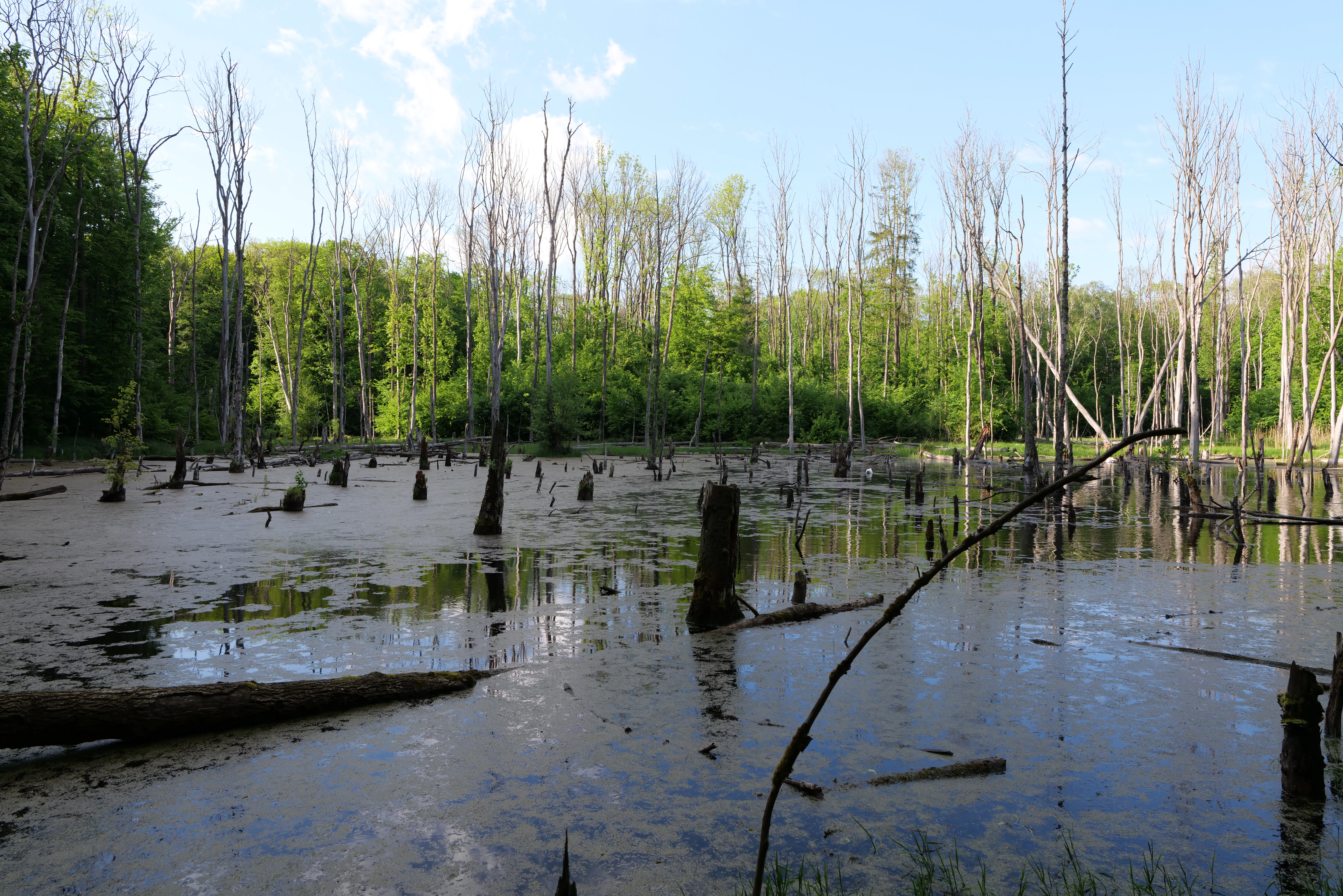
Arnimswalde Nature Reserve
View of the Arnimswalde nature reserve.

Arnimswalde Nature Reserve history and protected-area timeline

Arnimswalde was formally placed under nature protection on 12 September 1990 through a state ordinance that also established the Schorfheide-Chorin Biosphere Reserve as a whole, of which this reserve forms a part, listed there as NSG No. 8 "Arnimswalde".

The 1990 designation occurred during a period of rapid change in eastern Germany, when many former agricultural and forestry areas were being re-evaluated and newly protected as part of the post-reunification expansion of the nature conservation system. Integrating the small lake and forest landscape of Arnimswalde into the new biosphere reserve gave its habitats formal long-term protection and integrated it into a much larger ecological framework stretching across the Schorfheide and Chorin regions.

Since its establishment, the reserve has continued to function primarily as a habitat and species management area, with the conservation objective being the preservation and careful management of its lakes, mires, and forest communities.

Arnimswalde Nature Reserve landscape and geographic character

The landscape of Arnimswalde reflects the classic glacial landforms of the eastern Uckermark. It comprises gentle ridges, hollows, and small basins that hold lakes and mires, framed by continuous forest cover and interrupted by scattered wet meadows.

The lake basins are the visual and ecological centerpieces of the reserve. The Sabinensee and the Karutz lakes are small, irregularly shaped water bodies tucked into forested surroundings, while the Klare See contributes an additional portion of open water. Many of these lakes are extremely nutrient-poor or dystrophic, with dark, peat-stained waters and reedy margins. Between the lakes lie transition mires, lowland fens, and moist grasslands that occupy formerly wetter forested zones.

Forested areas cover much of the rest of the reserve. The woodlands include mixed beech forests of the Luzulo-Fagetum and Asperulo-Fagetum types, oak-hornbeam stands of the Carpinion betuli alliance, and wetter forests of alder and ash, particularly along watercourses. Beyond this, raised-bog forest communities also occur, adding to the diversity of vertical structures within the protected area. The road L 241 outlines the southern margin of the reserve but does not penetrate the lake and forest interior.

Arnimswalde Nature Reserve ecosystems, habitats, and plant life

Ecologically, Arnimswalde is best understood as a lake-mire-forest mosaic, in which closely interlocking habitat types have developed within a relatively small area. The reservoir of ecological value lies both in the variety of the habitats and in the close proximity in which they occur to one another.

The reserve contains a particularly rich set of lake-related habitats, including calcareous oligo-mesotrophic waters with charophyte vegetation, naturally eutrophic lakes with water-crowfoot pondweed communities, and dystrophic lakes and ponds. These lake types occur side by side, often separated by narrow bands of mire, which gives the lake system a high botanical and invertebrate diversity.

Wetland habitats are equally prominent. They include transition mires and quaking bogs, calcareous fens, and species-rich lowland hay meadows shaped by long traditional management. The functioning of these open wetland systems depends on ongoing mowing or grazing, which has shaped both the vegetation and the bird community.

Around the wetlands, the forested habitats range from relatively dry beech and oak stands on the higher ground to wet alluvial and bog-margin forests dominated by alder and ash. These kinds of woodland composition underline the steep gradients of nutrient availability and hydrology that are typical of the young moraine terrain of the Uckermark.

Arnimswalde Nature Reserve wildlife and species highlights

Arnimswalde's combination of lakes, fens, and forests supports a varied fauna, especially among species that depend on clean water and intact wetland margins. Among the species of joint European conservation interest that have been documented in the reserve are the greater mouse-eared bat and the European otter, both of which rely on mosaics of forest, water, and open land.

The wetland system is particularly important for amphibians. The fire-bellied toad, which is associated with sunny, lowland waters, and the crested newt, which depends on well-vegetated ponds, both find suitable breeding habitats in and around the reserve's lakes. The diverse dragonfly fauna, which includes the large whiteface dragonfly, reflects the good water quality and varied aquatic vegetation.

Two rare snails from the genus Vertigo are also recorded here as species of community interest, underscoring the conservation value of the area's calcareous fens and moist meadows. In combination, the bird, bat, amphibian, invertebrate, and mammal communities indicate an unusually rich ecological network for a reserve of Arnimswalde's size.

Arnimswalde Nature Reserve conservation status and protection priorities

Arnimswalde plays a clear conservation role at multiple administrative levels. It is formally designated as a Naturschutzgebiet under Brandenburg state law and as a habitat and species management area under the IUCN's Category IV system, which signals that active management is required to maintain its values.

At the European level, the habitats and species present in the reserve are protected under the EU Habitats Directive (Council Directive 92/43/EEC). Eleven different habitat types of community interest are present, ranging from calcareous lakes and dystrophic waters through transition mires and species-rich hay meadows to several types of beech, oak-hornbeam, and alluvial forest. This unusually broad habitat complement qualifies the area as a meaningful contributor to the Natura 2000 network in Brandenburg.

Seven Annex II species of community interest have been documented, including the greater mouse-eared bat, the otter, the crested newt, the fire-bellied toad, the large whiteface dragonfly, and two rare snail species. The presence of so many Annex II species within a relatively compact area significantly increases the conservation relevance of Arnimswalde beyond its immediate region.

In practical terms, the conservation strategy for the reserve rests on maintaining open water quality, preserving the hydrology of the mire systems, sustaining the open character of the meadows through appropriate management, and protecting the continuity of the forest cover around the lakes and bogs.

Arnimswalde Nature Reserve cultural meaning and human context

The cultural dimension of Arnimswalde is rooted primarily in the traditional rural land use of the Uckermark rather than in high-profile settlements or monuments. The reserve lies between two small villages, Böckenberg and Götschendorf, both of which are part of municipalities with a long history of agriculture, forestry, and small-scale fishing in the surrounding lake landscape.

The species-rich hay meadows and moist grasslands that form part of the reserve are themselves a product of this rural history, shaped over decades or centuries by mowing and grazing. This means that the open wetland habitats which today hold significant biodiversity are, in cultural ecological terms, the result of a long cohabitation between the local population and the landscape.

Wider regional context frames the protected area within the well-known Moravian and Uckermark culture of small manor villages, field-forest mosaics, and a deep-rooted relationship with the glacial lake landscape. Because much of the Uckermark is sparsely populated and shaped by long-standing traditions of land management, reserves like Arnimswalde fit into a regional identity in which nature, agriculture, and small rural communities are closely intertwined.

Top sights and standout views in Arnimswalde Nature Reserve

Arnimswalde's highlights lie in the unusual concentration of ecologically valuable habitats within its borders: four named lakes and parts of a fifth, surrounded by mires, wet meadows, and beech-oak forests, all within a single protected area of roughly 1,400 hectares. Eleven different habitat types of European conservation interest are documented here, ranging from calcareous oligo-mesotrophic lakes and dystrophic waters to transition mires, calcareous fens, lowland hay meadows, and several forest types.

The reserve's Annex II species list, which includes the otter, the fire-bellied toad, the crested newt, the greater mouse-eared bat, the large whiteface dragonfly, and two rare Vertigo snails, gives a clear measure of its biodiversity value. Its inclusion in the Schorfheide-Chorin Biosphere Reserve adds a regional dimension, embedding Arnimswalde into a much larger landscape protection effort in Brandenburg.

Best time to visit Arnimswalde Nature Reserve

Because Arnimswalde is primarily an ecological landscape rather than a developed visitor destination, any seasonal visit should align with the rhythms of the habitats themselves. Late spring and early summer are typically the most rewarding periods, when the wetland meadows are in bloom, amphibian breeding activity is at its peak in and around the lakes, and dragonflies become visible over open water.

Early autumn offers a quieter, more contemplative atmosphere, when forest colors begin to change and the wetland margins are less animated but still visually distinctive. In winter, the lake and mire landscape takes on a stark, minimal character, though practical access can be limited by local conditions.

In all seasons, the experience is shaped more by weather, light, and quiet observation than by infrastructure or scheduled activities.

Monthly climate preview

Long-term representative point measurements tracking monthly averages across Brandenburg

Arnimswalde Climate Normals, Mapped Annual Temperature and Precipitation Rhythms

Arnimswalde records documented multi-year temperature variations from sub-zero winter minimums to warm summer maximums alongside steady precipitation rates. Reviewing the complete twelve-month profile reveals detailed monthly averages and long-term climatological progression for this protected area.
Annual mean9 °C
-1 °C20 °C
Jan-1°
Feb
Mar
Apr
May13°
Jun17°
Jul20°
Aug19°
Sep15°
Oct
Nov
Dec
Warmest month
July

19.5 °C

Coolest month
January

-1 °C

Wettest month
July

2.5 mm/day

Driest month
April

1.1 mm/day

Park location guide

Geography guide, regional context, and park location map for Arnimswalde Nature Reserve

Arnimswalde Nature Reserve park geography, regions, and map view in Germany

Understand where Arnimswalde Nature Reserve sits in Germany through a broader geographic reading of the surrounding landscape, nearby location context, and its mapped position within the national park landscape.

How Arnimswalde Nature Reserve fits into Germany

Germany is a federal republic in Western and Central Europe with a population of over 83 million across sixteen constituent states. It is Europe's largest economy by nominal GDP and a major global exporter and importer. The capital is Berlin, and the country borders Denmark, Poland, Czech Republic, Austria, Switzerland, France, Luxembourg, Belgium, and the Netherlands.

Wider geography shaping Arnimswalde Nature Reserve in Germany

Germany is located in Western and Central Europe, spanning 357,022 km². It borders Denmark to the north, Poland and the Czech Republic to the east, Austria and Switzerland to the south, and France, Luxembourg, Belgium, and the Netherlands to the west. The country has coastlines on the Baltic Sea and North Sea to the north, with the Alps located in the southern region.

Map view of Arnimswalde Nature Reserve

Use this park location map to pinpoint Arnimswalde Nature Reserve in Germany, understand its exact geographic position, and read its mapped placement within the surrounding landscape more clearly.

Pigeon | © OpenStreetMap contributors

Location context for Arnimswalde Nature Reserve

Brandenburg

Explore detailed imagery of forests, mires, and glacial lake habitats across the nature reserve.

Arnimswalde Photos and Protected Area Scenery: Visualizing the Glacial Lake Landscape

Visual documentation of Arnimswalde reveals the intricate mosaic of small lakes, transition mires, and continuous beech-oak forests defining the Brandenburg terrain. Examining protected area photography provides clear insight into the glacial landforms and wetland habitats shaping the eastern Uckermark biosphere reserve.

Arnimswalde Nature Reserve

Park atlas

Compare regional glacial lake landscapes and connected forest reserves

Explore Parks Near Arnimswalde and Protected Areas Across Brandenburg

Browse other parks near Arnimswalde to discover similar glacial lake ecosystems and wetland habitats preserved across Brandenburg. Continuing into these adjacent protected landscapes provides wider geographic context for regional conservation terrain.
Nature reserveBrandenburg
Park boundaries overlap#1 closest

South

Krinertseen Nature Reserve: Protected Glacial Lakes and Bog Landscapes in Brandenburg

Essential geographic data for the Uckermark wetland conservation area.

Krinertseen provides a concentrated view of Brandenburg's post-glacial terrain. This nature reserve serves as an ecologically significant area defined by mesotrophic-alkaline lakes and active lake-succession mires. The site acts as a key component of the wider Schorfheide-Chorin conservation network, showcasing the complex relationship between regional hydrology and protected forest ecosystems.

Area
3.51 km²
Established
1990
IUCN
IV
Relief
Lowland
Nature reserveLandkreis Uckermark
1.9 km away#2 closest

Southwest

Endmoränenlandschaft bei Ringenwalde: Nature Reserve and Glacial Landscape Exploration

Geomorphology and protected forest geography in Landkreis Uckermark

This nature reserve stands as a textbook example of end moraine morphology shaped by Pleistocene glaciers. The area serves as a vital component of the broader Schorfheide-Chorin Biosphere Reserve, preserving a distinct system of forested ridges, basin lakes, and varied micro-relief that offers deep insight into the natural history of the Brandenburg region.

Area
5.69 km²
Established
1990
IUCN
IV
Protected areaBrandenburg
4.9 km away#3 closest

Northeast

Suckower Haussee Protected Area: Geographic Overview and Habitat Mosaic in Uckermark, Brandenburg

Mapping spring mires, wet meadows, and dry grassland ecosystems

Suckower Haussee preserves a diverse habitat gradient typical of the Uckermark district. The protected area features a unique juxtaposition of limnic, peat-forming wetland habitats and nutrient-poor dry grasslands. This site acts as an essential component of the regional conservation network in northeastern Brandenburg, demonstrating the importance of small-scale landscape protection.

Area
1.37 km²
Established
1990
Scope
Terrestrial
Water
Major water bodies
Nature reserveBrandenburg
5.3 km away#4 closest

Southwest

Winkel Nature Reserve: Glacial Landscape and Wetland Geography in Brandenburg, Germany

Mapping kettle-hole basins and moraine terrain

Winkel Nature Reserve serves as a vital protected area for studying the hydrological character of the Uckermark. The reserve features a dense network of small, water-filled kettle holes formed by melting glacial ice. This geographic record explores the interconnected wetland habitats and ground moraine surfaces that define this sensitive protected landscape in northeastern Germany.

Area
1.45 km²
Established
1990
IUCN
IV
Nature reserveBrandenburg
6.3 km away#5 closest

Southwest

Bollwinwiesen/Großer Gollinsee Nature Reserve: Brandenburg Protected Area Atlas

Oligotrophic lake chains and peat-forming mire landscapes

Bollwinwiesen/Großer Gollinsee forms a critical ecological anchor within the Schorfheide-Chorin Biosphere Reserve. The area preserves a distinct glacial mosaic where clear water, Sphagnum-dominated mires, and traditional wet meadows converge to create a protected landscape defined by its high ecological integrity and historic conservation status.

Area
9.075 km²
Established
1990
IUCN
IV
Relief
Lowland
Nature reserveBrandenburg
About 12 km away#6 closest

West

Buchheide Nature Reserve: Glacial Terrain and Forest Conservation in Brandenburg

Base-rich moraine and waterlogged habitat geography

The Buchheide nature reserve in Brandenburg offers a distinct case study in post-glacial landscape ecology. Centered on lime-rich ground moraine and seasonal wetness, the area supports specialized forest habitats. This site provides a clear view into the interactions between ancient geological formations, riparian zones, and current regional conservation strategies across the Uckermark.

Area
5.66 km²
Established
1990
IUCN
IV
Nature reserveBrandenburg
About 20 km away#7 closest

North

Zerweliner Koppel Nature Reserve: Mapped Protected Landscapes in the Brandenburg Region

A preserved mosaic of woodland and lakeside habitats

Located in the Uckermark district, Zerweliner Koppel represents a vital protected area characterized by its interweaving of wet and dry habitats. This nature reserve supports an array of ecosystems ranging from nutrient-poor lakes and calcareous fens to oak and beech forests, providing a stable refuge for diverse wildlife species in northeastern Germany.

Area
1.93 km²
Established
2005
IUCN
IV
Relief
Lowland
Nature reserveBrandenburg
About 23 km away#8 closest

West

Kleine Schorfheide Nature Reserve: Brandenburg Protected Area and Landscape Atlas

Mapped terrain, river floodplains, and forest mosaic in Northern Brandenburg

Spanning over 73 square kilometres, Kleine Schorfheide stands as a significant nature reserve in Brandenburg. It protects a vast, contiguous mosaic of open former military training lands, the natural Havel river floodplain, and the Himmelpforter Heide forest, creating a distinct regional landscape defined by its varied terrain and interconnected lake systems.

Area
73.75 km²
Established
1994
IUCN
IV

Common questions about visiting, size, designation, and location context for Arnimswalde Nature Reserve

Arnimswalde Nature Reserve FAQs for park facts, access, geography, and protected area context

Find quick answers about Arnimswalde Nature Reserve, including protected-area facts, park geography, trail and visitor context, and how the park fits into its surrounding country and regional landscape.
MoriAtlas Explorer

Continue Your Protected Areas Search Across the Global Atlas

Deepen your exploration by continuing the structured search for national parks and protected areas worldwide. Utilize the comprehensive filtering capabilities to compare different conservation landscapes and refine your understanding of global park geography. Discover more about the distribution and characteristics of protected natural areas.

Global natural geography