Mori Atlas logo
National parkAurora Memorial National Park

Discover the mapped boundaries and endemic bird habitat of this Sierra Madre forest landscape.

Aurora Memorial National Park: Philippines National Park Protected Area Atlas

Aurora Memorial National Park stands as a significant protected landscape within the Philippines, primarily situated on the eastern slopes of the Sierra Madre mountain range. Covering 5,676 hectares, this national park is a vital component of the region's geography, featuring predominantly lowland dipterocarp forests that transition into montane forests at higher elevations. Its strategic placement along the Bongabon-Baler road offers a window into one of the Philippines' most extensive mountain wilderness corridors, crucial for biodiversity and watershed integrity.

protected areaSierra Madre mountainslowland dipterocarp forestImportant Bird AreaCentral Luzonendemic birds

Aurora Memorial National Park

National park

Park overview

Structured park overview, official facts, and landscape profile for Aurora Memorial National Park

Aurora Memorial National Park park facts, protected area profile, and essential visitor context

Review the core facts for Aurora Memorial National Park, including designation, size, terrain, visitor scale, habitats, and operating context in one park-focused overview.

About Aurora Memorial National Park

Aurora Memorial National Park represents a significant protected area within the Sierra Madre mountain range, the longest continuous mountain chain in the Philippines. The park straddles the boundary between Nueva Ecija and Aurora provinces, occupying a transitional zone between lowland and montane forest environments. Its establishment in 1937 under Proclamation No. 220 marked an early effort in Philippine conservation history, with the original area of 2,356 hectares more than doubling by 1941 to its present extent. The park's dedication to Aurora Aragon Quezon in 1949 honored the First Lady and cemented the park's identity within the region's protected area network.

The park's location along the Bongabon-Baler road provides visitor access to a landscape characterized by forested ridges, valley systems, and the diverse ecological communities they support. While the park faces pressures from agricultural activities including both permanent and shifting cultivation known as kaingin, the core forest areas maintain ecological integrity. The protected area serves as a component of the broader Sierra Madre conservation landscape, which contains some of the Philippines' most extensive remaining forest cover and represents a critical watershed for surrounding lowland communities.

Quick facts and research context for Aurora Memorial National Park

Aurora Memorial National Park occupies 5,676 hectares along the Sierra Madre mountain range in Central Luzon, Philippines. The park sits at elevations up to 1,000 meters, supporting lowland dipterocarp forest as the dominant ecosystem with limited montane forest in higher areas. It was established in 1937 as Boñgabon-Baler National Park and rededicated to Aurora Aragon Quezon in 1949. The protected area holds IUCN Category V status as a protected landscape and seascape. It forms part of a critical ecological corridor within the Sierra Madre, the longest mountain range in the Philippines.

Protection and recognition

Documenting the terrestrial conservation framework established in 1949

Aurora Memorial National Park Protection Status and Designation History

Aurora Memorial National Park maintains a documented terrestrial protection status that dates back to its official establishment in 1949. Verifying the designation history and conservation scope helps researchers trace the historical development of protected areas across the region.

Protection details

Protection scope
Terrestrial
Designated year
1949
Transboundary protection
No
Park context

Deeper park guide and search-rich context for Aurora Memorial National Park

Aurora Memorial National Park history, landscape, wildlife, and travel context

Explore Aurora Memorial National Park through its history, landscape character, ecosystems, wildlife, conservation priorities, cultural context, and seasonal travel timing in a structured park guide built for atlas discovery and search intent.

Why Aurora Memorial National Park stands out

This park is especially known for its significant bird biodiversity and its role as an Important Bird Area. The Sierra Madre forest ecosystem supports populations of several endemic and threatened avian species including the Philippine eagle, one of the largest and most iconic eagles in the world. The park's rainforest environment provides critical habitat for the Philippine hawk-eagle, spotted imperial-pigeon, flame-breasted fruit-dove, green racket-tail, and whiskered pitta. Its designation as an IBA reflects the presence of significant populations of Philippine ducks and various endemic babbler species including the golden-crowned babbler and Luzon striped babbler. The park also supports the Luzon water-redstart, a distinctive bird species associated with the region's watercourses.

Aurora Memorial National Park history and protected-area timeline

Aurora Memorial National Park was originally established in 1937 through Proclamation No. 220 issued by President Manuel L. Quezon, initially designated as Boñgabon-Baler National Park. The original park encompassed 2,356 hectares at its founding. By 1941, the protected area was expanded to its current size of 5,676 hectares, more than doubling the initial designation. In May 1949, the park was officially dedicated to Aurora Aragon Quezon, the former First Lady of the Philippines and wife of President Quezon, receiving its present name in honor of her contributions to the nation. The park's establishment predates many Philippine protected areas and reflects early twentieth-century recognition of the Sierra Madre region's ecological significance.

Aurora Memorial National Park landscape and geographic character

The park occupies the eastern slopes of the Sierra Madre mountain range, spanning approximately 50 kilometers along the scenic Bongabon-Baler road. The terrain is characterized by mountainous topography with ridges and valleys oriented along the range's north-south axis. Elevation within the park reaches a maximum of 1,000 meters, a relatively modest altitude that supports lowland dipterocarp forest as the dominant vegetation type. The landscape features forested slopes descending toward the coastal plain, with the park serving as a transitional zone between the more extensive mountain forests of the Sierra Madre and the agricultural lowlands of Aurora province. The terrain's steepness and the forest cover contribute to the area's watershed function for downstream communities.

Aurora Memorial National Park ecosystems, habitats, and plant life

The ecological character of Aurora Memorial National Park is defined by its position within the Sierra Madre, one of the Philippines' most biodiverse regions. The park's primary forest type is lowland dipterocarp forest, characterized by large emergent trees of the Dipterocarpaceae family that dominate the canopy in areas of relatively flat to rolling terrain. At higher elevations approaching the park's maximum altitude of 1,000 meters, limited areas of montane forest occur, featuring different species assemblages adapted to cooler, more humid conditions. The forest ecosystem supports a diverse array of plant species, though detailed inventories specific to the park are limited in available documentation. The protected area forms part of a larger forest continuum within the Sierra Madre mountain range, contributing to regional biodiversity conservation.

Aurora Memorial National Park wildlife and species highlights

Aurora Memorial National Park supports notable wildlife diversity, with particular significance attached to its avian fauna. The park has been designated an Important Bird Area by BirdLife International, recognizing its importance for populations of several bird species. Notable species include the Philippine duck, a endemic waterfowl species, and the spotted imperial-pigeon and flame-breasted fruit-dove, both representing endemic fruit-dove species found only in the Philippines. The park provides habitat for the Philippine eagle and Philippine hawk-eagle, two of the country's most impressive raptors. Additional notable species include the green racket-tail, a distinctive parrot-like bird, and the whiskered pitta, a colorful ground-dwelling bird. The babbler family is represented by the golden-crowned babbler and Luzon striped babbler, both endemic to Luzon. The Luzon water-redstart frequents the park's watercourses. Beyond avifauna, the park supports various amphibians and reptiles, though specific species documentation is limited in available sources.

Aurora Memorial National Park conservation status and protection priorities

The park holds IUCN Category V status as a protected landscape, reflecting its designation as an area where human interaction with the landscape has shaped the environment over time while maintaining conservation values. Its recognition as an Important Bird Area underscores the park's significance for biodiversity conservation at the regional and global levels. The Sierra Madre mountain range represents one of the Philippines' most extensive remaining forest areas, and protected areas like Aurora Memorial National Park play a critical role in maintaining ecological corridors and forest cover. The park faces ongoing conservation challenges from agricultural expansion and resource extraction, but its long-established protected status provides a framework for ongoing management and conservation action.

Aurora Memorial National Park cultural meaning and human context

The park is named in honor of Aurora Aragon Quezon, former First Lady of the Philippines, to whom the park was dedicated in 1949. This naming reflects the park's connection to Philippine national history and the recognition of individuals significant in the country's development. The surrounding region has historical connections to the Spanish colonial period and subsequent American administration, though detailed cultural heritage documentation specific to the park area is limited in available sources. Local communities in the provinces of Nueva Ecija and Aurora maintain connections to the landscape, with traditional land uses including agriculture and resource gathering that intersect with the park's conservation mandate.

Top sights and standout views in Aurora Memorial National Park

The park's designation as an Important Bird Area makes it particularly significant for birdwatching and ornithological interest, with multiple endemic species present including the Philippine eagle and various fruit-dove and babbler species. The scenic Bongabon-Baler road traverses the park, providing access to the Sierra Madre's forest environment. As one of the older protected areas in the Philippines, established in 1937, the park represents decades of conservation commitment. The lowland dipterocarp forest ecosystem, while not as dramatic as montane or cloud forest, provides important habitat for species adapted to this increasingly rare forest type.

Best time to visit Aurora Memorial National Park

The park can be visited throughout the year, though the dry season from November to May typically offers more reliable access and clearer conditions for outdoor activities. The wet season from June to October brings regular rainfall to the region, which maintains the forest's lush appearance but may affect road conditions and accessibility. Bird activity may be more observable during the dry season when water sources become more concentrated. The park's elevation of up to 1,000 meters provides a slightly cooler environment than the surrounding lowlands, offering some respite from the typical tropical heat of Central Luzon.

Monthly climate preview

Long term weather by month averages and seasonal precipitation cycles for the park

Aurora Memorial National Park Climate and Monthly Average Temperature Profile

Historical climatology at the representative elevation of 282 meters shows warm conditions year round, with average temperatures between 23 and 27 degrees Celsius and variable daily precipitation. Accessing the complete monthly climate normals for Aurora Memorial National Park provides verified long term data to compare shifting moisture cycles and heat patterns.
Annual mean25 °C
23 °C27 °C
Jan23°
Feb24°
Mar25°
Apr26°
May27°
Jun27°
Jul26°
Aug26°
Sep26°
Oct25°
Nov25°
Dec24°
Warmest month
May

27 °C

Coolest month
January

23 °C

Wettest month
July

10.6 mm/day

Driest month
March

2.8 mm/day

Park location guide

Geography guide, regional context, and park location map for Aurora Memorial National Park

Aurora Memorial National Park park geography, regions, and map view in Philippines

Understand where Aurora Memorial National Park sits in Philippines through a broader geographic reading of the surrounding landscape, nearby location context, and its mapped position within the national park landscape.

How Aurora Memorial National Park fits into Philippines

The Philippines, officially the Republic of the Philippines, is an archipelagic nation in Southeast Asia comprising approximately 7,641 islands categorized into three main geographical divisions: Luzon, Visayas, and Mindanao. Located in the western Pacific Ocean, it shares maritime borders with Taiwan, Japan, Palau, Indonesia, Malaysia, Vietnam, and China. Manila serves as the capital city, while Quezon City is the most populated city, both within Metro Manila.

Wider geography shaping Aurora Memorial National Park in Philippines

The Philippines is an archipelagic nation in Southeast Asia, positioned in the western Pacific Ocean. Its islands are bounded by the South China Sea to the west, Philippine Sea to the east, and Celebes Sea to the south. The country shares maritime borders with Taiwan to the north, Japan to the northeast, Palau to the east and southeast, Indonesia to the south, Malaysia to the southwest, Vietnam to the west, and China to the northwest.

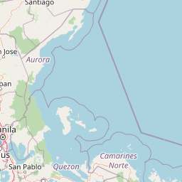
Map view of Aurora Memorial National Park

Use this park location map to pinpoint Aurora Memorial National Park in Philippines, understand its exact geographic position, and read its mapped placement within the surrounding landscape more clearly.

Pigeon | © OpenStreetMap contributors

Location context for Aurora Memorial National Park

AuroraNueva Ecija
Park atlas

Compare protected landscapes and national parks across the Sierra Madre mountain range and the Central Luzon region.

Parks Near Aurora Memorial National Park: Explore Other Protected Areas in Central Luzon

Continue your exploration by browsing other national parks and protected areas located geographically near Aurora Memorial National Park in the Central Luzon region. This atlas view helps you compare diverse conservation landscapes, trace the Sierra Madre wilderness corridor, and understand the broader regional protected-area context.
Illustration of a river with bamboo boats, people rowing, limestone cliffs, and trees
National parkNueva Ecija
About 37 km away#1 closest

Southwest

Minalungao National Park: Protected Landscape and Geographic Context in Nueva Ecija

Explore the mapped boundaries of this Philippines national park.

Delve into the specifics of Minalungao National Park, a protected natural area identified as a national park in the Philippines. This exploration focuses on its distinct geographic identity within Nueva Ecija, highlighting the importance of its mapped boundaries and regional landscape. Understand the park's role as a protected land entity for atlas-based discovery.

Area
20.18 km²
Established
1967
IUCN
V
Relief
Upland
National parkBulacan
About 47 km away#2 closest

Southwest

Biak-na-Bato National Park: National Park Atlas and Geographic Context in Bulacan

Explore protected landscapes and mapped terrain.

Biak-na-Bato National Park is a key protected area in Bulacan, Philippines, identified for its national park designation. This entry provides specific details on its geographic positioning and mapped features, essential for atlas-based research and understanding the distribution of protected lands within the region. Dive into the landscape context and mapped boundaries that define this significant natural entity.

Area
21.17 km²
Established
1937
IUCN
V
Relief
Mountain
Wildlife reserveNueva Ecija
About 50 km away#3 closest

Northwest

Pantabangan, Carranglan Watershed Forest Reserve: Geography and Protected Area Context

Mountainous watershed landscapes in Northern Nueva Ecija

Spanning the meeting point of the Sierra Madre and Caraballo mountains, this protected wildlife reserve encompasses the massive Pantabangan Lake reservoir. The region provides a complex look at how natural forest ecosystems and large-scale water management infrastructure integrate within the Philippine landscape, offering a unique perspective on regional hydrology and botanical biodiversity.

Area
845 km²
Established
1969
IUCN
VI
Relief
Mountain
Nature reserveBulacan
About 60 km away#4 closest

Southwest

Angat Watershed Forest Reserve: Mountain Watershed Geography and Protected Forest Terrain

A critical nature reserve in the Sierra Madre of Bulacan

This protected area anchors the water supply for Metro Manila while preserving extensive submontane forests and mountain ridges in Central Luzon. The landscape features deep river valleys, hydroelectric reservoirs, and peaks like Mount Oriod that define the local geography of this important conservation zone.

Area
623.09 km²
Established
1927
IUCN
VI
Relief
Mountain
National parkPhilippines
About 78 km away#5 closest

West

Mount Arayat National Park: Philippines National Park and Protected Landscape Atlas Entry

Mapped geography and protected natural landscape context.

Mount Arayat National Park represents a distinct protected area within the Philippines, serving as a focal point for geographic and landscape exploration. This detailed entry offers insight into its mapped boundaries and its significance as a national park within the archipelago's rich natural tapestry. Users can leverage this information for structured discovery of the park's terrain and its place in the regional geography of the Philippines.

Relief
Mountain
Climate
Tropical
Scope
Terrestrial
Nature reserveMetro Manila
About 87 km away#6 closest

Southwest

La Mesa Watershed Reservation: Mapping the Urban Rainforest and Water Catchment

A critical nature reserve within the Metro Manila region.

La Mesa Watershed Reservation is the last major lowland forest block within Metro Manila, functioning as a vital nature reserve and drinking water catchment for the metropolitan area. The area features a complex mosaic of closed-canopy rainforest, reservoir wetlands, and swampforest, providing a distinct geographic counterpoint to the surrounding urban density. It remains a key case study in urban conservation and hydrological management for the Philippine capital.

Area
26.59 km²
Established
2007
Visitors
300K annual
Relief
Upland
Protected landscapeAurora
About 89 km away#7 closest

Northeast

Simbahan-Talagas Protected Landscape: Geographic Profile and Sierra Madre Forest Mapping

An essential watershed and dipterocarp habitat in Aurora province.

Analyze the protected boundaries and hydrological features of the Simbahan-Talagas Protected Landscape. This region features a dense network of river systems and continuous dipterocarp forest cover that extends across the eastern foothills of the Sierra Madre mountain range in Luzon.

Area
22.66 km²
Established
2000
IUCN
V
Relief
Mountain
Protected landscapeRizal
About 91 km away#8 closest

South

Upper Marikina River Basin Protected Landscape: Watershed Geography and Sierra Madre Mapping

A critical forest reserve and hydrological basin in Rizal

Covering the upper reaches of the Marikina River, this protected landscape forms a massive forested block within the southern Sierra Madre. The area serves as a primary catchment system, defined by its rugged mountain ridges, descending river corridors, and long-standing role in regional water management. Mapping these protected lands reveals the essential link between mountain ecosystems and downstream hydrological stability.

Area
261.256 km²
Established
1904
IUCN
V
Relief
Mountain

Common questions about visiting, size, designation, and location context for Aurora Memorial National Park

Aurora Memorial National Park FAQs for park facts, access, geography, and protected area context

Find quick answers about Aurora Memorial National Park, including protected-area facts, park geography, trail and visitor context, and how the park fits into its surrounding country and regional landscape.
MoriAtlas Explorer

Continue Your Protected Areas Search Across the Global Atlas

Deepen your exploration by continuing the structured search for national parks and protected areas worldwide. Utilize the comprehensive filtering capabilities to compare different conservation landscapes and refine your understanding of global park geography. Discover more about the distribution and characteristics of protected natural areas.

Global natural geography