Mori Atlas logo
Biosphere reserveBabtų-Varluvos miškų biosferos poligonas

Analyzing the protected forest landscape, continuous woodland corridors, and ecological monitoring zone in Kaunas district.

Babtų-Varluvos miškų biosferos poligonas: A Detailed Geographic Atlas of Central Lithuanian Woodlands

Babtų-Varluvos miškų biosferos poligonas represents a core protected landscape within the central Lithuanian lowlands. This forest massif, managed by the Kaunas Forestry District, provides an essential habitat for mature, broadleaf-rich woodland ecosystems. Through mapping and ecological research, the reserve demonstrates the value of continuous forest corridors in sustaining biodiversity and monitoring human impact on natural terrain.

biosphere polygonforest reservelowland forestbroadleaf forestwoodpecker habitatconservation research

Babtų-Varluvos miškų biosferos poligonas

Biosphere reserve

Park overview

Structured park overview, official facts, and landscape profile for Babtų-Varluvos miškų biosferos poligonas

Babtų-Varluvos miškų biosferos poligonas park facts, protected area profile, and essential visitor context

Review the core facts for Babtų-Varluvos miškų biosferos poligonas, including designation, size, terrain, visitor scale, habitats, and operating context in one park-focused overview.

About Babtų-Varluvos miškų biosferos poligonas

Babtų-Varluvos miškų biosferos poligonas lies in the central part of Lithuania, within Kaunas district, at the heart of the Varluvos–Babtų forest massif. This forest block is one of the larger continuous woodland tracts in the region, sitting between two significant transport corridors: the A1 highway linking Vilnius, Kaunas, and Klaipėda to the west, and regional road 222 running from Kaunas toward Vandžiogala to the east. The polygon's boundaries extend from the village of Saustinė in one direction to Babtų in another, creating an elongated forest reserve approximately 13 kilometers long.

The polygon's ecological identity centers on mature and semi-mature mixed and broadleaf-rich forest stands, which provide habitat structure essential for many woodland species. Such habitat is increasingly rare in heavily used lowland European landscapes, giving the area particular conservation significance despite its moderate size. The polygon's work combines passive protection with active research: monitoring protected species, conducting biodiversity inventories, running ecological experiments in natural complexes and their surroundings, and analyzing how surrounding human activity shapes forest ecosystems over time.

While the biosphere polygon is not a tourist-focused national park, it functions as an important node within Lithuania's broader network of forest protected areas. Its institutionally recognized role as a research and monitoring site, combined with its position within a major forest massif, gives it enduring value for Lithuanian nature conservation and forest ecology.

Quick facts and research context for Babtų-Varluvos miškų biosferos poligonas

Babtų-Varluvos miškų biosferos poligonas is administratively classified under IUCN Category VI, meaning it is a protected area with sustainable use of natural resources. It was established in 2004 within the Varluvos–Babtų forest massif of Kaunas district, central Lithuania, and is managed by Kaunas Forestry District.

The polygon covers approximately 44 square kilometers of forest, oriented along a roughly 13-kilometer north-to-south axis. Its purpose is to conserve forest ecosystems, support biodiversity research and protected species monitoring, and analyze the impact of human activity on surrounding natural complexes.

Protection and recognition

Documented terrestrial scope, management framework, and conservation recognition

Babtų-Varluvos miškų biosferos poligonas Protection Status and Designation

Babtų-Varluvos miškų biosferos poligonas maintains a documented terrestrial protection scope within its designated conservation framework. Structured management data details the official status and administrative boundaries established for the protected landscape.

Protection details

Protection scope
Terrestrial
Park context

Deeper park guide and search-rich context for Babtų-Varluvos miškų biosferos poligonas

Babtų-Varluvos miškų biosferos poligonas history, landscape, wildlife, and travel context

Explore Babtų-Varluvos miškų biosferos poligonas through its history, landscape character, ecosystems, wildlife, conservation priorities, cultural context, and seasonal travel timing in a structured park guide built for atlas discovery and search intent.

Why Babtų-Varluvos miškų biosferos poligonas stands out

The polygon is best known for safeguarding mature, structurally complex forest habitat in central Lithuania, with a particular emphasis on two woodpecker species: the middle spotted woodpecker and the white-backed woodpecker. Both birds depend on old stands with substantial deadwood and broadleaf components, making the polygon a meaningful stronghold for these species in Lithuania. Beyond its importance for woodpeckers, the area is recognized as a long-term ecological research site where biodiversity, conservation experiments, and assessments of human impact on forest ecosystems are carried out over years and decades.
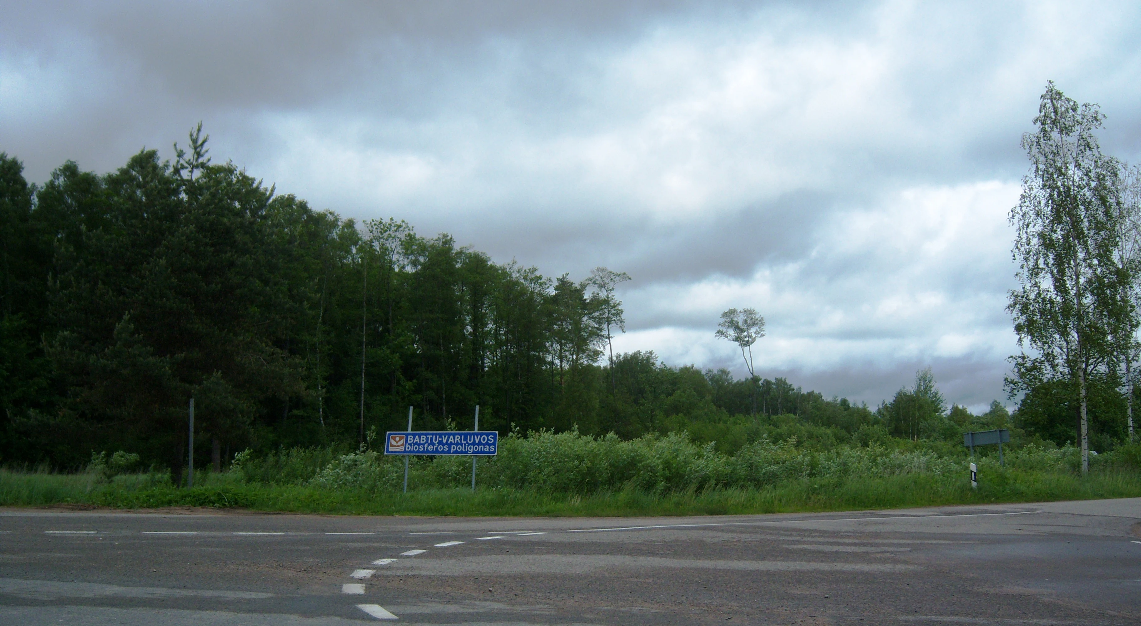
A blue informational road sign stands at the edge of a dense forest with a cloudy sky overhead.
A road-side sign marking the entrance to the Babtu-Varluva biosphere polygon in Lithuania.

Babtų-Varluvos miškų biosferos poligonas history and protected-area timeline

The biosphere polygon was formally established in 2004 within the Varluvos–Babtų forest massif in Kaunas district. Its creation reflected a broader Lithuanian and European interest in setting aside representative forest tracts for long-term ecological research, biodiversity monitoring, and the conservation of species tied to mature woodland.

From its founding, the polygon was placed under the management of Kaunas Forestry District, integrating it into the institutional forestry system while granting it a distinct conservation and research mandate. Over the years, the reserve has functioned as a working site for ongoing protected-species monitoring, biodiversity surveys, and conservation experiments aimed at understanding human impact on forest ecosystems.

Babtų-Varluvos miškų biosferos poligonas landscape and geographic character

The landscape is dominated by continuous lowland forest typical of central Lithuania, with woodland cover shaping nearly the entirety of the reserve. The polygon's elongated form, stretching about 13 kilometers from north to south, reflects the natural orientation of the Varluvos–Babtų forest massif between two transport corridors.

The terrain consists of relatively gentle lowland relief characteristic of this part of Lithuania, with mature and semi-mature forest stands providing structural complexity. The mix of mixed and broadleaf-rich forest types gives the area a layered appearance, supporting varied microhabitats, deadwood accumulations, and relatively undisturbed understorey conditions that are increasingly uncommon in intensively used landscapes.

Babtų-Varluvos miškų biosferos poligonas ecosystems, habitats, and plant life

Ecologically, the polygon protects lowland broadleaf and mixed forest ecosystems that have long been shaped by natural forest dynamics rather than uniform plantation forestry. These mature stands host a relatively rich woodland community, with habitat conditions that support cavity-nesting birds, saproxylic invertebrates, fungi, and other organisms tied to old-growth features.

The area's forest ecosystems are valued not only for species conservation but also as reference sites for studying natural processes in Lithuanian woodlands. By preserving a substantial forest block in a region otherwise affected by roads, settlements, and forestry operations, the polygon provides a baseline against which changes in surrounding ecosystems can be measured.

Babtų-Varluvos miškų biosferos poligonas wildlife and species highlights

Wildlife significance in the polygon is strongly associated with two flagship woodpecker species: the middle spotted woodpecker and the white-backed woodpecker. Both depend on mature forest with old trees, cavities, and sufficient deadwood, and their presence is often treated as an indicator of high-quality broadleaf forest habitat.

Beyond these focal species, the broader forest supports typical woodland fauna of lowland Lithuania, with a community shaped by the availability of mature trees, structural diversity, and the relative continuity of forest cover across the massif. The polygon serves as a monitoring site for these populations, helping track their status over time.

Babtų-Varluvos miškų biosferos poligonas conservation status and protection priorities

The polygon carries conservation significance as a long-term protected research site within an actively managed forestry region. Classified under IUCN Category VI, it combines sustainable resource management with conservation aims, in contrast with strictly protected reserves that exclude use.

Its conservation role rests on three pillars: preserving forest ecosystems, maintaining populations of protected species such as the middle spotted woodpecker and the white-backed woodpecker, and supporting scientific research that informs forest management policy. By continuously generating data on biodiversity and human impact, the polygon contributes evidence-based insights to Lithuanian forest conservation practice.

Babtų-Varluvos miškų biosferos poligonas cultural meaning and human context

The polygon's cultural context is tied to long-standing human relationships with the Varluvos–Babtų forest massif, a historically important woodland tract in Kaunas district. The area's settlement pattern, marked by villages such as Saustinė and Babtų on its margins, reflects a traditional Lithuanian rural landscape in which forests have served as sources of livelihood, identity, and ecological reference.

While the polygon itself is primarily ecological rather than cultural in focus, its position between a major highway and a regional road, and its proximity to Kaunas, gives it a distinctive role as a forested counterpoint to surrounding transport and settlement landscapes.

Top sights and standout views in Babtų-Varluvos miškų biosferos poligonas

A IUCN Category VI biosphere polygon located in central Lithuania, established in 2004 within the Varluvos–Babtų forest massif. Its continuous forest habitat covers roughly 44 square kilometers and supports mature lowland woodland ecosystems increasingly rare in intensively used landscapes.

The polygon is particularly notable for supporting populations of the middle spotted woodpecker and the white-backed woodpecker, and for serving as a long-term site for biodiversity monitoring, conservation experiments, and studies of human impact on forest ecosystems.

Best time to visit Babtų-Varluvos miškų biosferos poligonas

The polygon is a research-oriented protected area rather than a public visitor destination, so any visit would typically be tied to field research, education, or supervised excursions. For observing forest character, late spring and early summer generally offer richer bird activity and more vivid understorey conditions, while autumn highlights forest fruiting and seasonal change. Specific seasonal access arrangements are not documented in available sources.
Monthly climate preview

Long-term monthly temperature and precipitation patterns recorded across representative coordinates

Babtų-Varluvos miškų biosferos poligonas Climate Normals and Annual Temperature Rhythm

Representative coordinates record measured monthly temperature swings from sub-zero winter lows to warm summer highs alongside consistent year-round precipitation rates. Examining the full twelve-month profile provides complete historical climate normals for detailed environmental analysis.
Annual mean6 °C
-5 °C18 °C
Jan-5°
Feb-4°
Mar
Apr
May12°
Jun16°
Jul18°
Aug17°
Sep12°
Oct
Nov
Dec-3°
Warmest month
July

18.1 °C

Coolest month
January

-5.2 °C

Wettest month
July

3 mm/day

Driest month
March

1.6 mm/day

Park location guide

Geography guide, regional context, and park location map for Babtų-Varluvos miškų biosferos poligonas

Babtų-Varluvos miškų biosferos poligonas park geography, regions, and map view in Lithuania

Understand where Babtų-Varluvos miškų biosferos poligonas sits in Lithuania through a broader geographic reading of the surrounding landscape, nearby location context, and its mapped position within the national park landscape.

How Babtų-Varluvos miškų biosferos poligonas fits into Lithuania

Lithuania is a unitary semi-presidential republic and one of three Baltic states in Northern Europe. It lies on the eastern coast of the Baltic Sea, with Vilnius as its capital and largest city. The country regained independence in 1990 after Soviet occupation and joined the European Union in 2004. Lithuania has a population of about 2.9 million and covers an area of 65,300 km².

Wider geography shaping Babtų-Varluvos miškų biosferos poligonas in Lithuania

Lithuania is situated on the eastern shore of the Baltic Sea in Northern Europe. It borders Latvia to the north, Belarus to the east and south, Poland to the south, and Russia's Kaliningrad Oblast to the southwest. The country also has a maritime border with Sweden to the west. The terrain is largely flat with rolling hills, numerous lakes, and rivers. The Nemunas River is the longest river in the country.

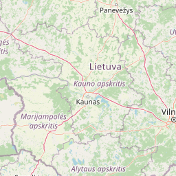
Map view of Babtų-Varluvos miškų biosferos poligonas

Use this park location map to pinpoint Babtų-Varluvos miškų biosferos poligonas in Lithuania, understand its exact geographic position, and read its mapped placement within the surrounding landscape more clearly.

Pigeon | © OpenStreetMap contributors

Location context for Babtų-Varluvos miškų biosferos poligonas

Kauno rajonas

Visualizing mature forest habitats and terrain across the protected Lithuanian reserve

Babtų-Varluvos miškų biosferos poligonas Photos and Landscapes

Visual documentation of Babtų-Varluvos miškų biosferos poligonas reveals the structural complexity of continuous lowland woodlands and broadleaf habitats. Examining these protected-area photographs provides deeper insight into the ecological character and terrain features of the reserve.

A blue informational road sign stands at the edge of a dense forest with a cloudy sky overhead.

Park atlas

Compare surrounding lowland forests and connected woodland habitats across central Lithuania

Parks Near Babtų-Varluvos miškų biosferos poligonas and Regional Protected Areas

Browse nearby protected landscapes and forest reserves located close to Babtų-Varluvos miškų biosferos poligonas. Compare regional woodland geography and woodland conservation networks across central Lithuania.
Watercolor illustration of a wooden boardwalk path winding through a flat landscape with scattered trees, soft grasses, and muted natural colors.
Nature reserveKauno rajono savivaldybė
About 22 km away#1 closest

Southeast

Dubravos rezervatinė apyrubė: Protected Nature Reserve and Baltic Forest Geography

Central Lithuania protected landscape and wetland mapping

This nature reserve in the Kaunas district protects a rare combination of mature pine forest and open raised bog habitats. By preserving long term undisturbed ecological processes, it provides a stable reference point for forest dynamics in the region. Explore the structural complexity of these coniferous stands and the distinct wetland characteristics of this protected Baltic landscape.

Area
1.2 km²
Established
1994
IUCN
Ia
Relief
Lowland
Biosphere reserveUkmergė District Municipality
About 52 km away#2 closest

Northeast

Viliukų, Karpių miškai Biosphere Reserve: Regional Protected Area Geography and Maps

Broadleaved forests and wetland ecosystems in central Lithuania

Gain insights into the protected landscape of Viliukų, Karpių miškai in the Ukmergė District. This biosphere reserve provides a detailed view of lowland forest ecosystems, characterized by spruce and birch dominance within an undulating terrain that sustains rare insect and plant communities.

Area
7.772 km²
Established
2012
Relief
Lowland
Scope
Terrestrial
Watercolor painting showing green hills, trees, a body of water, and grassy vegetation
National parkLithuania
About 54 km away#3 closest

Southeast

Trakai National Historic Park: Medieval Heritage and Lake District Protected Landscape

Explore Lithuania's historic park and its mapped geographic context.

Trakai National Historic Park offers a rich tapestry of medieval history intertwined with a captivating lake district landscape. As a protected area in southeastern Lithuania, it preserves significant architectural monuments, including the iconic Trakai Castle, set against a backdrop of interconnected lakes, forests, and wetlands. MoriAtlas provides a structured overview of its geographic boundaries and regional setting, facilitating atlas-style exploration of this historically significant protected landscape.

IUCN
V
Access
Moderate access
Scope
Mixed
Nature reserveTrakai District Municipality
About 61 km away#4 closest

Southeast

Mergiškių gamtinis rezervatas Protected Nature Reserve in Trakai District Municipality

Strictly protected hornbeam woodland and hilly glacial terrain

Mergiškių gamtinis rezervatas is a protected area in Lithuania dedicated to conserving mature hornbeam-dominated hill forest. Located within the Trakai District Municipality, the reserve provides a critical habitat for threatened species and maintains the natural integrity of hilly glacial landscapes typical of the Aukštadvaris region.

Area
1.57 km²
Established
1996
IUCN
Ia
Relief
Upland
Biosphere reserveLithuania
About 71 km away#5 closest

Northeast

Taujėnų, Užulėnio miškų biosferos poligonas: Protected Forest Landscapes of Lithuania

Central Baltic lowland conservation territory

Spanning central Lithuania, this biosphere reserve preserves a vast mosaic of deciduous, coniferous, and mixed forest lands. The territory supports high-quality bird habitats through disciplined forestry practices and the protection of complex wetland and peatland systems, making it a reference site for lowland forest conservation.

Area
44.19 km²
Established
2004
Relief
Lowland
Climate
Temperate
Watercolor illustration showing a landscape with forests, a river, and distant hills
National parkLithuania
About 85 km away#6 closest

South

Dzūkija National Park: Explore Lithuania's Largest Protected Forest and Inland Dune Landscapes

Mapped protected area geography and natural terrain of the Dainava region.

Delve into the protected landscape of Dzūkija National Park, Lithuania's expansive national park renowned for its vast primeval pine forests and extraordinary inland dune formations. This page provides a detailed atlas-style view of the park's mapped boundaries, diverse terrain, and significant natural features, offering insight into its protected territory and regional geographic importance. Examine the unique wetland systems and forest ecosystems that make this a crucial area for protected land discovery.

Area
584.53 km²
Established
1991
IUCN
II
Visitors
30K annual
Biosphere reserveAnykščiai District Municipality
About 101 km away#7 closest

Northeast

Šimonių Giria Biosphere Reserve in Anykščiai District Municipality, Lithuania

Protected forest massif and glacial landscape mapping

Šimonių giria stands as a prominent biosphere reserve in northern Lithuania, offering an expansive, pine dominated woodland defined by post glacial sands, extensive peat bogs, and a network of interior lakes. This structured overview details the park geographical features, from its role in the Natura 2000 network to its critical function as a biodiversity monitoring site within the Anykščiai District Municipality.

Area
232.61 km²
Established
2004
Relief
Lowland
Climate
Temperate
Watercolor painting of a tranquil marshland scene with reeds in the foreground, rolling green hills, and a pale sky.
Nature reservePodlaskie Voivodeship
About 104 km away#8 closest

South

Ostoja Augustowska Nature Reserve: Protected Forest and Wetland Atlas of Podlaskie

Mapped wilderness corridors in the Polish lowlands

Ostoja Augustowska serves as a major ecological hub in Podlaskie Voivodeship, comprising extensive pine and spruce woodlands linked with diverse peatland systems. The site provides a critical corridor for rare forest wildlife while preserving ancient stands of old-growth timber. Gain insights into the complex geography of this Natura 2000 protected territory through its documented terrain, hydrological networks, and mosaic of rare boreal habitat types.

Area
1,070.69 km²
Established
2009
Relief
Lowland
Climate
Temperate

Common questions about visiting, size, designation, and location context for Babtų-Varluvos miškų biosferos poligonas

Babtų-Varluvos miškų biosferos poligonas FAQs for park facts, access, geography, and protected area context

Find quick answers about Babtų-Varluvos miškų biosferos poligonas, including protected-area facts, park geography, trail and visitor context, and how the park fits into its surrounding country and regional landscape.
MoriAtlas Explorer

Continue Your Protected Areas Search Across the Global Atlas

Deepen your exploration by continuing the structured search for national parks and protected areas worldwide. Utilize the comprehensive filtering capabilities to compare different conservation landscapes and refine your understanding of global park geography. Discover more about the distribution and characteristics of protected natural areas.

Global natural geography