

Mori Atlas logo
Nature reserveBaiyer River Sanctuary

A vital nature reserve in the Western Highlands Province featuring diverse avian habitats and closed canopy forest.

Baiyer River Sanctuary: Mapping the Mid-Elevation Highland Rainforest and Protected River Valley

Baiyer River Sanctuary serves as a significant nature reserve in the Western Highlands Province of Papua New Guinea, protecting 740 hectares of mid-elevation rainforest. Rising along the forested ridges and river valleys, this site features a distinctive oak-dominated landscape between 800 and 1200 metres in elevation. Researchers recognize the sanctuary as a core habitat for numerous bird-of-paradise species, forming a scientifically important reference point for highland ornithology.

highland rainforestbird-of-paradise habitatornithologynature reserveWestern Highlands Papua New Guineaoak forest

Baiyer River Sanctuary

Nature reserve

Park overview

Structured park overview, official facts, and landscape profile for Baiyer River Sanctuary

Baiyer River Sanctuary park facts, protected area profile, and essential visitor context

Review the core facts for Baiyer River Sanctuary, including designation, size, terrain, visitor scale, habitats, and operating context in one park-focused overview.

About Baiyer River Sanctuary

Baiyer River Sanctuary occupies a stretch of forested river valley on the eastern side of the Western Highlands, set about 40 kilometres from the provincial capital of Mt Hagen. Its setting along the Baiyer River places it firmly within the highland rainforest zone that defines much of central New Guinea, where steep ridges, deeply cut streams, and persistent rainfall create conditions favorable for closed-canopy forest. The reserve's elevation band of roughly 800 to 1200 metres places it in an intermediate position between the lowland and montane forest zones, a transition that is biologically rich and especially well represented by birdlife.

The sanctuary was declared in 1968, during the period of Australian administration of the Territory of Papua and New Guinea. Its purpose from the outset has been the protection of forest and wildlife rather than the development of visitor infrastructure, and that orientation has shaped the reserve's character for decades. Over the years It has come to occupy an important place among the older protected natural areas of the country, alongside reserves associated with wider New Guinean conservation efforts in the second half of the twentieth century.

Despite its long history, the reserve's built infrastructure has not been stable. The article notes that the area experienced considerable unrest over the years, and that the main buildings were burned down. As a result, the sanctuary today carries a dual character: an ecologically intact forest block with strong birdlife, on one hand, and a site with limited or damaged visitor facilities and active renovation, on the other. This combination gives Baiyer River Sanctuary its profile as a conservation site whose ecological value consistently outpaces its physical development.

Quick facts and research context for Baiyer River Sanctuary

Baiyer River Sanctuary is a 740-hectare protected nature reserve along the Baiyer River in Western Highlands Province of Papua New Guinea. It was established in 1968 under the former Australian administration of the Territory of Papua and New Guinea and has remained a forest reserve since then.

The reserve sits between 800 and 1200 metres in elevation, in a high-rainfall environment of roughly 260 centimetres per year, and is dominated by oak forest. It supports a substantial bird list of around 185 species, including birds-of-paradise; a small mammal community built around rats, opossums, kangaroos, and bandicoots; and a small number of native amphibians, including a frog species known only from the reserve.

Protection and recognition

Documented terrestrial protection scope and international recognition data

Baiyer River Sanctuary Protection Status and Formal Designation Records

Baiyer River Sanctuary maintains a documented terrestrial protection scope within the global conservation network. Structured management records outline the official administrative status and designated territory parameters for the protected landscape.

Protection details

Protection scope
Terrestrial
Transboundary protection
No
Park context

Deeper park guide and search-rich context for Baiyer River Sanctuary

Baiyer River Sanctuary history, landscape, wildlife, and travel context

Explore Baiyer River Sanctuary through its history, landscape character, ecosystems, wildlife, conservation priorities, cultural context, and seasonal travel timing in a structured park guide built for atlas discovery and search intent.

Why Baiyer River Sanctuary stands out

The sanctuary is best known as a mid-elevation refuge for New Guinea's iconic birds-of-paradise and other rainforest birds. Among its recorded 185 bird species, birds-of-paradise are the standout attraction, both acoustically and visually, drawing naturalists interested in the families for which the island of New Guinea is most famous. Equally distinctive is the reserve's oak-dominated rainforest on the slopes above the Baiyer River. This botanical character, combined with high rainfall and elevation, gives Baiyer a forest profile that differs from both lowland New Guinea rainforest and the higher alpine communities, making it a recognized reference site for the bird communities of this altitudinal band.

Baiyer River Sanctuary history and protected-area timeline

The reserve was opened on 13 January 1968 by the Australian administration that governed the Territory of Papua and New Guinea at that time. Its establishment came during a period when several nature reserves were being declared across the territory to safeguard representative examples of New Guinea's distinctive flora and fauna, including bird species found nowhere else.

Since independence, the sanctuary has continued to function as a protected nature reserve. Over time the reserve was expanded from its original footprint to its present extent of about 740 hectares. Its later years have been marked less by further expansion than by management challenges. The reserve area experienced considerable unrest over the years, during which the main buildings were burned down, leaving the sanctuary without the original facilities. A period of in-progress renovation has been underway, attempting to restore core infrastructure, even as the surrounding forest cover has remained largely intact and ecologically functional.

Baiyer River Sanctuary landscape and geographic character

The landscape of Baiyer River Sanctuary is defined by the valley of the Baiyer River and the forested ridges rising above it in the Western Highlands of Papua New Guinea. The reserve occupies a mid-elevation band of about 800 to 1200 metres, a transitional zone between lowland and high-mountain environments. The terrain is structured around steep highland ridges, persistent rainfall, and the dendritic drainage pattern of the Baiyer River and its tributaries.

Forest cover is the dominant visual feature of the reserve. The article records that much of the forest remains in a virgin state, with a continuous closed canopy extending across the protected area. Oak species are noted as the predominant forest trees here, giving the reserve a distinctively highland character compared with lowland New Guinea rainforest further north. The combination of elevation, geology, river valley, and intact forest gives the sanctuary a strikingly uniform green profile, broken only by the course of the river and the small clearings that historically supported built facilities.

Baiyer River Sanctuary ecosystems, habitats, and plant life

Ecologically, Baiyer River Sanctuary sits within the highland rainforest bioclimatic zone that characterizes much of central New Guinea. The very high annual rainfall, on the order of 260 centimetres, supports dense, evergreen forest with a relatively closed structure. The reserve is dominated by oak forest at its elevation band, a notable botanical signature that helps set the sanctuary apart from the dipterocarp-dominated lowland rainforests elsewhere in the country.

This combination of rainfall, elevation, and forest type has produced a habitat profile that supports substantial biodiversity, particularly in birds. The reserve records a sizeable avifauna for its area, including the families for which New Guinea is internationally recognized. Smaller mammal communities and a limited amphibian presence complete the ecological picture, including a frog species that, on the basis of specimens collected within the reserve, is known from no other location. Regeneration of the forest has continued even after disturbance to built infrastructure, leaving the ecological substrate of the sanctuary largely unaffected.

Baiyer River Sanctuary wildlife and species highlights

The sanctuary's most prominent wildlife is its birdlife, with around 185 recorded species. Birds-of-paradise are a defining feature of this avifauna, lending the reserve its reputation as a destination for ornithologists and naturalists interested in the group for which New Guinea is globally renowned. Other rainforest bird families characteristic of the central highlands are also present, contributing to the constant chorus of bird sound described by visitors to intact forest in the area.

Mammal diversity is more modest, with about eight recorded mammal species. The native mammal community is built around small and medium-sized groups typical of New Guinea's highland forests rather than large charismatic mammals, including rats, opossums, small wallabies and forest kangaroos, and bandicoots. Among amphibians, the frog Litoria oenicolen has so far been documented from the reserve only, on the basis of two specimens, giving Baiyer a particular scientific value in amphibian terms even within a bird-dominated ecosystem.

Baiyer River Sanctuary conservation status and protection priorities

Baiyer River Sanctuary is significant primarily as one of the older formal forest and wildlife reserves in Papua New Guinea, declared in 1968 under Australian administration and maintained as a protected area since independence. Its 740-hectare extent sits within a continuous highland rainforest matrix, and the article describes the forest cover as good and largely still in a virgin state, indicating a sustained conservation outcome at the habitat level despite the difficulties in managing built infrastructure.

The reserve also has scientific conservation value. It supports a substantial bird checklist anchored by birds-of-paradise, holds the only known population of at least one amphibian species recorded from New Guinea, and preserves oak-dominated highland forest that is increasingly rare across New Guinea's settled valleys. Together these features give Baiyer River Sanctuary a conservation profile that extends beyond simple legal protection to include habitat representation, endemism, and long-term reference value for New Guinea's highland biodiversity.

Baiyer River Sanctuary cultural meaning and human context

The sanctuary sits within one of the most populated highland regions of Papua New Guinea, where customary land tenure and traditional highland village life continue alongside modern provincial administration centred on Mt Hagen. While the reserve itself is a formally declared protected area, its setting in the Western Highlands means it is framed by long-standing patterns of highland settlement and land use.

The reserve's modern history also reflects broader moments of social tension in the region. The article notes that the area of the reserve had been the scene of considerable unrest over the years, and that the main buildings were burned down during that period. This context situates the sanctuary within the social as well as the ecological landscape of the Western Highlands, and helps explain why its built infrastructure has not kept pace with the continuity of its forest cover.

Top sights and standout views in Baiyer River Sanctuary

The strongest single feature of Baiyer River Sanctuary is the density and character of its birdlife. With around 185 recorded species in a relatively compact 740-hectare area, and with birds-of-paradise among the most distinctive residents, the reserve offers one of the oldest dedicated highland refuges for these emblematic New Guinea birds.

Equally notable are the intact oak-dominated rainforests on the slopes above the Baiyer River, the retention of a continuous closed canopy despite local disturbance, the high annual rainfall that sustains this forest profile, and the amphibian endemism represented by Litoria oenicolen. Together these elements give the sanctuary a clear identity as a scientifically meaningful highland forest reserve rather than a developed tourist park.

Best time to visit Baiyer River Sanctuary

The reserve occupies a zone of very high annual rainfall distributed throughout the year, so there is no simple dry season in the manner of monsoonal areas further from the equator. Visiting at any time of year implies working within a high-rainfall forest environment in which trails may be wet and bird activity can remain a constant presence.

For a visit focused on birdwatching, particular attention to early morning hours during periods of relatively settled weather is generally beneficial, because forest birds in New Guinea are typically most active in the first hours of daylight. Visitors should expect the experience to be shaped more by the forest itself, and by the condition of trails and access roads, than by seasonal climatic variables in the temperate-zone sense.

Monthly climate preview

Long-term representative temperature and precipitation patterns across the protected terrain

Baiyer River Sanctuary Climate Normals and Monthly Weather Records

Representative coordinates record measured monthly temperature ranges and precipitation rhythms across the protected landscape from 1991 to 2020. Examining the complete twelve-month climatology provides deeper insight into long-term averages for annual temperature variation.
Annual mean19 °C
18 °C19 °C
Jan19°
Feb19°
Mar19°
Apr19°
May19°
Jun18°
Jul18°
Aug18°
Sep19°
Oct19°
Nov19°
Dec19°
Warmest month
December

19.1 °C

Coolest month
July

18.3 °C

Wettest month
April

8.2 mm/day

Driest month
August

2.9 mm/day

Park location guide

Geography guide, regional context, and park location map for Baiyer River Sanctuary

Baiyer River Sanctuary park geography, regions, and map view in Papua New Guinea

Understand where Baiyer River Sanctuary sits in Papua New Guinea through a broader geographic reading of the surrounding landscape, nearby location context, and its mapped position within the national park landscape.

How Baiyer River Sanctuary fits into Papua New Guinea

Papua New Guinea is an island nation in the southwestern Pacific Ocean, comprising the eastern half of the island of New Guinea and hundreds of offshore islands. It gained independence from Australia in 1975 and operates as a constitutional monarchy within the Commonwealth. The country is renowned for having the world's highest linguistic diversity, with over 840 known languages.

Wider geography shaping Baiyer River Sanctuary in Papua New Guinea

Papua New Guinea occupies the eastern half of the island of New Guinea and hundreds of smaller islands in Melanesia. It shares a land border with Indonesia to the west and has maritime boundaries with Australia to the south and the Solomon Islands to the east. The terrain is predominantly mountainous, with the land supporting extraordinary biodiversity.

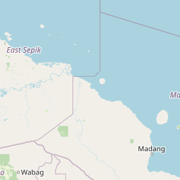
Map view of Baiyer River Sanctuary

Use this park location map to pinpoint Baiyer River Sanctuary in Papua New Guinea, understand its exact geographic position, and read its mapped placement within the surrounding landscape more clearly.

Pigeon | © OpenStreetMap contributors

Location context for Baiyer River Sanctuary

Western Highlands Province
Park atlas

Compare regional protected areas and adjacent highland forest reserves across Western Highlands Province

Explore Other Parks Near Baiyer River Sanctuary And Protected Landscapes

Browse protected areas near Baiyer River Sanctuary to examine connected highland forest reserves and regional biodiversity patterns. Continuing the comparison reveals broader ecological links across the surrounding New Guinea mountain terrain.
Stylized illustration of a mountain with waterfalls, river, and trees under a bright sky with clouds
Protected areaPapua New Guinea
About 102 km away#1 closest

East

Mount Wilhelm Protected Area: Papua New Guinea's Highest Peak and Alpine Terrain

Mapped geography and protected landscape context for a key Oceania peak.

Mount Wilhelm represents a significant protected area and the highest mountain in Papua New Guinea. Situated within the Bismarck Range, its dramatic granite peak defines a unique alpine environment, transitioning from dense rainforests to high-altitude grasslands. The presence of twin glacial lakes, Piunde and Aunde, adds to its distinctiveness, offering insight into the region's varied natural terrain and its role as a key geographical landmark.

Relief
Mountain
Climate
Alpine
Access
Moderate access
Scope
Terrestrial
Wildlife reserveSouthern Highlands Province
About 136 km away#2 closest

Southwest

Lake Kutubu Wildlife Reserve: Geographic Boundaries and Highland Ecosystem Mapping

Protected freshwater terrain in the Southern Highlands Province

Lake Kutubu represents an essential protected landscape in the Papua New Guinea highlands, serving as a critical upland basin for diverse freshwater species. This overview highlights the reserve's unique geographic setting, covering its expansive 19-kilometer stretch, surrounding montane forests, and its role within the Kikori River catchment. Access detailed landscape context and regional environmental data for this globally significant lacustrine ecosystem.

Area
51.84 km²
Relief
Mountain
Scope
Terrestrial
Water
Water-dominated
Wildlife reserveChimbu Province
About 163 km away#3 closest

Southeast

Crater Mountain Wildlife Management Area: Geography and Protected Land Boundaries in Chimbu Province

Central highland rainforest and cordillera wilderness terrain.

Crater Mountain Wildlife Management Area encompasses a massive tract of undisturbed highland rainforest across the central cordillera of Papua New Guinea. This protected zone demonstrates a unique intersection of tropical montane biodiversity and community-led conservation, providing an essential refuge defined by steep topography, persistent moisture, and continuous forest cover that stretches across the Chimbu Province.

Relief
Highland
Water
Major water bodies
Wildlife reserveMorobe Province
About 295 km away#4 closest

East

YUS Conservation Area: Mapping the Geographic Range of a Community-Led Wildlife Reserve

Protected tropical forest landscapes in Morobe Province, Papua New Guinea

YUS Conservation Area represents a significant shift in regional conservation, protecting a massive altitudinal gradient on the Huon Peninsula. From coastal coral reef environments to the rugged ridges of the Saruwaged Mountains, the area preserves critical montane habitats and riverine corridors. This dataset provides insight into its unique geography, spanning lowland forests to highland peaks while showcasing a model of land management driven by customary community agreements.

Area
760 km²
Established
2009
Relief
Mountain
Climate
Tropical
National parkMorobe Province
About 335 km away#5 closest

Southeast

McAdam National Park; Geographic Atlas of Protected Highland Forests in Morobe Province

Highland montane forest and rugged ridge landscapes

McAdam National Park preserves a rugged stretch of montane rainforest in Papua New Guinea's Bulolo region. Rising over 1,200 meters, this protected area features steep forested slopes and narrow valleys that define the geography of the Morobe interior. Our atlas provides insights into the park's boundaries and its position within the broader highland ecosystem of the province.

Relief
Mountain
Scope
Terrestrial
Water
Minor water
National parkSouth Papua
About 447 km away#6 closest

Southwest

Wasur National Park National Park: Mapped Protected Boundaries in South Papua

Explore the geographic context and park boundaries.

Delve into the specific protected area identity of Wasur National Park, a national park situated within the South Papua region. This page offers detailed geographic context, focusing on its mapped boundaries and its significance as a protected landscape. It provides a factual basis for understanding the park's place within Indonesia's network of natural areas for structured atlas exploration.

Area
4,138 km²
Established
1990
IUCN
II
Visitors
2.3K annual
Wildlife reserveWestern Province
About 484 km away#7 closest

Southwest

Tonda Wildlife Management Area: Atlas of Protected Wetlands and Savanna Landscapes

Geographic overview of Papua New Guinea's largest wetland conservation zone

Spanning nearly 6,000 square kilometres of floodplain, Tonda Wildlife Management Area is defined by its exceptionally flat terrain and shifting mosaic of monsoon forest, tidal channels, and freshwater marshes. This protected landscape functions as an essential ecological bridge within the Trans-Fly ecoregion, maintaining deep connections to international conservation partners while preserving the integrity of its native bird and mammal habitats.

Area
5,900 km²
Established
1975
Protected areaQueensland
About 529 km away#8 closest

Southwest

Warul Kawa Indigenous Protected Area: A Geographic Profile of a Remote Torres Strait Sand Cay

Protecting northern Australian reef platforms and marine habitats

Warul Kawa Indigenous Protected Area, or Deliverance Island, defines a unique landscape of sand cays and shallow algal reef platforms in the far north of Queensland. As a key site for flatback turtle breeding and migratory green turtles, the area offers a rare example of a near-pristine marine environment. Its geography highlights the intersection of Indigenous land management and high-integrity tropical island ecosystems.

Established
2001
Relief
Lowland
Climate
Tropical
Access
Remote access

Common questions about visiting, size, designation, and location context for Baiyer River Sanctuary

Baiyer River Sanctuary FAQs for park facts, access, geography, and protected area context

Find quick answers about Baiyer River Sanctuary, including protected-area facts, park geography, trail and visitor context, and how the park fits into its surrounding country and regional landscape.
MoriAtlas Explorer

Continue Your Protected Areas Search Across the Global Atlas

Deepen your exploration by continuing the structured search for national parks and protected areas worldwide. Utilize the comprehensive filtering capabilities to compare different conservation landscapes and refine your understanding of global park geography. Discover more about the distribution and characteristics of protected natural areas.

Global natural geography

