
Viewpoints
Park geography
Explore recorded boundary geometry, lowland relief, and diverse wetland ecosystems.
Biebrza National Park Geography: Mapped Boundaries, Terrain, and Regional Landscape Context
The geographic profile for Biebrza National Park encompasses 592.23 square kilometers of lowland terrain situated within the Podlaskie Voivodeship. This structured data overview includes key hydrological features such as rivers and streams, alongside classified wetland habitats, forest cover, and significant natural terrain points found throughout the park area.
Poland's largest national park protecting one of Europe's most significant wetland wilderness areas
Biebrza National Park
Biebrza National Park is Poland's largest national park, situated in the northeastern Podlaskie Voivodeship along the Biebrza River valley. Established in 1993, the park encompasses 592.23 square kilometers of remarkably intact fenlands, marshes, forests, and meadows that represent one of the most significant wetland ecosystems in Europe. The Biebrza Marshes form the heart of this protected landscape, comprising the largest and most valuable remaining lowland peat bogs in Poland and among the most important in Europe. This vast wetland complex provides critical habitat for rare wetland birds, including the park's emblematic species the ruff, as well as supporting substantial populations of moose and beaver. In 1995, the park was designated as a Ramsar Wetland Site of International Importance, recognizing its outstanding universal value. The park's headquarters are located in the village of Osowiec-Twierdza, within the historic 19th-century Osowiec Fortress complex near Goniądz.
- Location
- Poland
- Park type
- National park
- Established
- 1993
- Area
- 592.2 km²
Location overview
Podlaskie Voivodeship administration and territorial scope
Biebrza National Park Geography and Location Context in Poland
Biebrza National Park is situated within Poland and spans the Podlaskie Voivodeship administrative region. Official records confirm the territorial scope without transboundary, coastal, island, or marine classifications.
- Countries
- Poland
- Regions
- Podlaskie Voivodeship
- Primary location
- Podlaskie Voivodeship
- Geographic setting
- Inland
Boundary and coordinates
Mapped perimeter geometry and derived spatial measurements
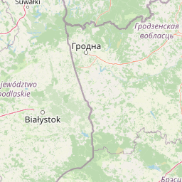
Biebrza National Park Boundary Map and Geographic Extent
Interactive boundary mapping defines the spatial extent and regional geometry of the protected area. Accompanying dimensional metrics outline the recorded surface area, coordinate limits, and geographic span.
- Boundary area
- 598.1 km²
- Boundary perimeter
- 426.8 km
- Northernmost point
- 53.7429° N
- Southernmost point
- 53.2143° N
- Easternmost point
- 23.511° E
- Westernmost point
- 22.4303° E
- Geographic centre
- 53.5039° N, 22.7585° E
- North–south span
- 58.8 km
- East–west span
- 71.8 km
Terrain and natural features
Lowland relief classification and registered natural features
Biebrza National Park Terrain and Named Natural Features
Biebrza National Park features a lowland relief classification alongside recorded wetlands, rivers, and viewpoints. Linked feature cards supply names, types, and spatial relationships for each registered natural entity.
Selected named natural features
Streams
Biebła
Rivers
Dybła
Rivers
Wissa
Rivers
Ełk
Wetlands
Czerwone Bagno
Environmental setting
Temperate lowland wetlands, riverine valleys, and partial forest cover
Biebrza National Park Environmental Setting and Classification Data
Recorded landscape features, habitat types, and dominant water systems combine to outline the physical setting of Biebrza National Park. Associated classifications connect stored environmental data to broader atlas destinations across the region.
- Relief
- Lowland
- Climate
- Temperate
- Water
- Water-dominated
- Forest cover
- Partial forest
- Seasonality
- Year-round
Landscape features
Wetland · Marsh · Rivers · Valleys · Grassland · Forest
Habitat types
Wetland · Riverine habitat · Grassland · Temperate broadleaf forest
Park atlas
Compare regional protected areas and wetland reserves across the surrounding territory
Explore Parks Near Biebrza National Park and Connected Protected Landscapes
Browsing other parks near Biebrza National Park reveals broader regional geography and connected wetland ecosystems. Continuing into adjacent protected areas provides valuable context for comparing lowland fenlands and river valley habitats.
National parkPodlaskie Voivodeship
Park boundaries overlap#1 closest
Northeast

Biebrzański Park Narodowy: A Protected Wetland Landscape in Podlaskie Voivodeship, Poland
Mapped river valley and peatland geography.
Located in the northeast of Poland, Biebrzański Park Narodowy protects a sprawling, flat basin defined by the slow-meandering Biebrza River. This critical protected area encompasses rare peat bogs, floodplain meadows, and alder carrs, functioning as a vital refuge for wetland species within the broader Podlaskie Voivodeship landscape.
- Area
- 592.23 km²
- Established
- 1993
- Visitors
- 23.2K annual
- Relief
- Lowland
Nature reservePodlaskie Voivodeship
Park boundaries overlap#2 closest
Northeast
Ostoja Augustowska Nature Reserve: Protected Forest and Wetland Atlas of Podlaskie
Mapped wilderness corridors in the Polish lowlands
Ostoja Augustowska serves as a major ecological hub in Podlaskie Voivodeship, comprising extensive pine and spruce woodlands linked with diverse peatland systems. The site provides a critical corridor for rare forest wildlife while preserving ancient stands of old-growth timber. Gain insights into the complex geography of this Natura 2000 protected territory through its documented terrain, hydrological networks, and mosaic of rare boreal habitat types.
- Area
- 1,070.69 km²
- Established
- 2009
- Relief
- Lowland
- Climate
- Temperate
Nature reservePodlaskie Voivodeship
About 13 km away#3 closest
South
Rezerwat przyrody Bagno Wizna II: Protected Peatland and Bog Terrain in Podlaskie Voivodeship
Mapped nature reserve and raised bog geography in northeastern Poland.
Rezerwat przyrody Bagno Wizna II functions as a specialized nature reserve in the Kotlina Biebrzańska, protecting rare raised bog vegetation. The site illustrates the intersection of active conservation efforts and regional drainage history, serving as a distinct geographic landmark within the wider protected land network of Podlaskie Voivodeship.
- Area
- 0.796 km²
- Established
- 1967
- Relief
- Lowland
- Climate
- Temperate
Nature reservePodlaskie Voivodeship
About 14 km away#4 closest
Northeast
Rezerwat przyrody Mały Borek: Pine Bore Forest and Peatland Geography in Podlaskie
Protected nature reserve in the Augustów Primeval Forest
Rezerwat przyrody Mały Borek is a significant nature reserve located in the Podlaskie Voivodeship of Poland. The area is defined by its extensive pine bore forests, central raised bogs, and transition zones of alder swamp. As part of the Natura 2000 network, it provides essential habitat and stands as a key scientific reference for the natural forest landscape of the Augustów Plain.
- Area
- 0.905 km²
- Established
- 1959
- Relief
- Lowland
- Scope
- Terrestrial
National parkPodlaskie Voivodeship
17 km away#5 closest
South
Narew National Park: Discover Poland's Premier Wetland National Park with Unique River Geography
Explore its mapped boundaries and rich protected landscape.
Narew National Park represents a significant protected area within the Podlaskie Voivodeship, distinguished by its one-of-a-kind anastomosing river system where the Narew River splits into numerous interconnected channels. This dynamic wetland environment provides critical habitat and showcases a complex interplay of water, land, and diverse ecosystems. Users can explore the park's geographic features, understand its protected landscape status, and appreciate its vital role within the regional atlas through detailed mapping and factual context.
- Area
- 73.5 km²
- Established
- 1996
- IUCN
- II
- Relief
- Lowland
National parkPodlaskie Voivodeship
17 km away#6 closest
South
Narwiański Park Narodowy: Mapped Wetland Geography and Protected Floodplain Landscapes
Examining the hydrologic patterns and marshland terrain of the Narew River valley.
Narwiański Park Narodowy features a unique, water-dominated geography in Podlaskie Voivodeship. This protected area centers on the anastomosing Narew River, creating a shifting mosaic of streams, oxbows, and managed grasslands that serves as a vital refuge for wetland birds and aquatic species within the broader Polish landscape.
- Area
- 68.1 km²
- Established
- 1996
- Visitors
- 15K annual
- Relief
- Lowland
Nature reservePodlaskie Voivodeship
About 26 km away#7 closest
Southwest
Rezerwat przyrody Dębowe Góry: Protected Sessile Oak Forest in Podlaskie Voivodeship
Ecologically intact lowland forest and rare plant habitat
Rezerwat przyrody Dębowe Góry stands as a protected sanctuary for light-loving sessile oak communities in Podlaskie Voivodeship. Its rolling lowland terrain and rich understory flora represent an essential fragment of Poland's natural woodland heritage, functioning as a key study area within the broader Czerwony Bór forest landscape context.
- Area
- 0.993 km²
- Established
- 2001
- Relief
- Lowland
- Scope
- Terrestrial
National parkPodlaskie Voivodeship
27 km away#8 closest
Northeast
Wigierski Park Narodowy: Mapped Protected Landscapes of Northeastern Poland
A regional atlas of postglacial terrain and lake ecosystems.
Wigierski Park Narodowy represents a vital expanse of protected land in the Podlaskie Voivodeship. This profile offers insights into its glacial moraine ridges, kettle hole topography, and the specific distribution of forest-fringed bog habitats that define this distinct segment of the Lithuanian Lake District.
- Area
- 150.898 km²
- Established
- 1989
- Visitors
- 110K annual
- Relief
- Upland
MoriAtlas Explorer
Continue Exploring the Protected Landscapes and Wetlands of Biebrza National Park
Deepen your knowledge of the Biebrza River valley through our structured geographic datasets and map-focused analysis. MoriAtlas provides a clear look at the terrain, ecological boundaries, and regional context of this essential Polish wilderness area.
Browse next
Global natural geography
Explore related park routes
Explore MoriAtlas Global ParksBrowse All MoriAtlas ParksGlobal Park Map DiscoveryMoriAtlas: Browse All CountriesBrowse All MoriAtlas ContinentsNational Park Environment AtlasGrand Canyon National Park AtlasYellowstone National Park AtlasYosemite National Park Atlas and GeographySerengeti National Park AtlasGalápagos National Park Protected LandscapeBanff National Park Geography and AtlasKruger National Park Atlas EntryUluṟu-Kata Tjuṯa National Park AtlasExplore Uluru-Kata Tjuta National Park GeographyPlitvice Lakes National Park AtlasFiordland National Park Protected LandscapeGreat Smoky Mountains National Park AtlasAfghanistan National Parks and Protected AreasAlbania National Parks and Protected AreasAlgeria National Parks and Protected AreasAmerican Samoa National Parks and Protected AreasAndorra National Parks and Protected AreasAngola National Parks and Protected AreasAntarctica National Parks and Protected AreasAntigua and Barbuda Park List