
Mori Atlas logo
Nature reserveBiesenhorster Sand

A rare urban protected area showcasing dry grassland and glacial outwash plain ecosystems.

Biesenhorster Sand Nature Reserve: Exploring the Glacial Sand Landscapes of Berlin

(Naturschutzgebiet Biesenhorster Sand)

Biesenhorster Sand is a compact nature reserve situated within the eastern districts of Berlin, where ice-age meltwater deposits created a distinct glacial outwash plain. This protected area harbors a rare mosaic of dry grassland, open sand surfaces, and tall herb vegetation, providing a critical refuge for threatened plant and insect species. The landscape reflects a unique intersection of geological history and active conservation management within a dense urban environment.

dry grasslandurban nature reservesand outwash plainglacial landscaperare speciesinsect diversity
A flat-style digital illustration of a scenic valley with a winding dirt path in the foreground, surrounded by trees, with large cliffs and a waterfall in the background.

Biesenhorster Sand

Nature reserve

Park overview

Structured park overview, official facts, and landscape profile for Biesenhorster Sand

Biesenhorster Sand park facts, protected area profile, and essential visitor context

Review the core facts for Biesenhorster Sand, including designation, size, terrain, visitor scale, habitats, and operating context in one park-focused overview.

About Biesenhorster Sand

Biesenhorster Sand is a compact urban nature reserve in eastern Berlin that protects one of the city's most ecologically valuable open-land habitats. The reserve lies at the meeting point of the Lichtenberg and Marzahn-Hellersdorf boroughs, between the neighborhoods of Karlshorst and Biesdorf, and is bounded by major rail infrastructure: the Berlin outer ring railway to the east, the U5 subway line to the north, and the Berlin–Frankfurt (Oder) railway and Wuhlheide S-Bahn station to the south. Kleingarten allotments border the western edge.

The defining physical feature of the reserve is a glacial sand outwash plain, a so-called Sanderfläche, formed during the ice age when meltwater from retreating glaciers deposited thick layers of sand in the Warsaw-Berlin Urstromtal. This geological legacy produced open, well-drained, nutrient-poor sandy soils that historically cannot sustain dense forest, instead favoring dry grassland (Trockenrasen), open sand patches, scattered tree groups, tall herb fringes, and solitary shrubs. The dry grassland strips can reach widths of up to 450 meters, and in summer the bare sand surfaces can heat to around 65 degrees Celsius, creating microclimates reminiscent of much warmer regions.

Ecologically, the reserve punches well above its weight. Botanists have counted 382 fern and flowering plant species, 21 of them on Germany's Red List. Among them are species classified as threatened with extinction, such as kidney vetch (Anthyllis vulneraria), dropwort (Filipendula vulgaris), and conical catchfly (Silene conica), as well as a notable rediscovery: the slit-leaved cranesbill, previously considered extinct in Berlin. The insect fauna is even richer, with 1,324 recorded insect species including 388 macro-moth species, of which 111 are on the Red List. Twelve insect species had been considered extinct in Berlin, and several beetle and wild bee species had not been seen in the region for a century. The reserve is also notable for hosting Berlin's only significant population of the blue-winged sand grasshopper (Sphingonotus caerulans) and a range of reptiles, especially the protected sand lizard.

For birds, the site functions as a breeding ground for 33 species, including several open-land specialists typical of dry grassland habitats: the tawny pipit, crested lark, woodlark, northern wheatear, red-backed shrike, and common linnet, all of which are Red List species in Germany. The combination of sandy soils, dry open ground, and the absence of intensive human disturbance after the 1990s has produced a small but ecologically dense refuge that demonstrates how intensively shaped urban-industrial land can recover into a high-value nature area when left to develop with active management.

Quick facts and research context for Biesenhorster Sand

Biesenhorster Sand is a 42.9-hectare nature reserve (Naturschutzgebiet) in eastern Berlin, straddling the boundary between the boroughs of Lichtenberg and Marzahn-Hellersdorf. It lies within the glacial Warsaw-Berlin Urstromtal and consists mainly of an ice-age sand outwash plain, an uncommon habitat type in the Berlin region.

The reserve was officially designated on 18 March 2021, following decades of conservation work by NABU Berlin that began in the mid-1990s. Surveys have documented 382 species of ferns and flowering plants, 1,324 insect species, and 778 beetle species on the site, making it one of the biologically richest small protected areas in the city. It is also a bird-breeding area for 33 species, including several Red List grassland specialists.

Protection and recognition

Documented territory management and formal recognition parameters

Biesenhorster Sand Protection Status and Terrestrial Conservation Data

Terrestrial protection status records for Biesenhorster Sand outline formal conservation governance and management scope. Verified administrative parameters provide clear documentation regarding the ecological territory without external assumptions.

Protection details

Protection scope
Terrestrial
Park context

Deeper park guide and search-rich context for Biesenhorster Sand

Biesenhorster Sand history, landscape, wildlife, and travel context

Explore Biesenhorster Sand through its history, landscape character, ecosystems, wildlife, conservation priorities, cultural context, and seasonal travel timing in a structured park guide built for atlas discovery and search intent.

Why Biesenhorster Sand stands out

Biesenhorster Sand is most notable for being a relict dry grassland and open sand ecosystem in the middle of Berlin, supporting an extraordinary density of rare species for a small urban reserve. It is recognized for the recovery of species previously thought extinct in Berlin and Brandenburg, including a plant species (slit-leaved cranesbill) and several insect species that had not been recorded in the region for a century or more. The site is also distinguished by its glacial origin. The ice-age sand deposits that formed the Warsaw-Berlin Urstromtal give the area its characteristic sandy soils, which in summer heat up to extreme surface temperatures and create ideal conditions for dry-grassland specialists, ground-nesting insects, and reptiles such as the sand lizard. The result is a compact, ecologically dense refuge that contrasts sharply with the surrounding dense cityscape of Berlin's eastern districts.
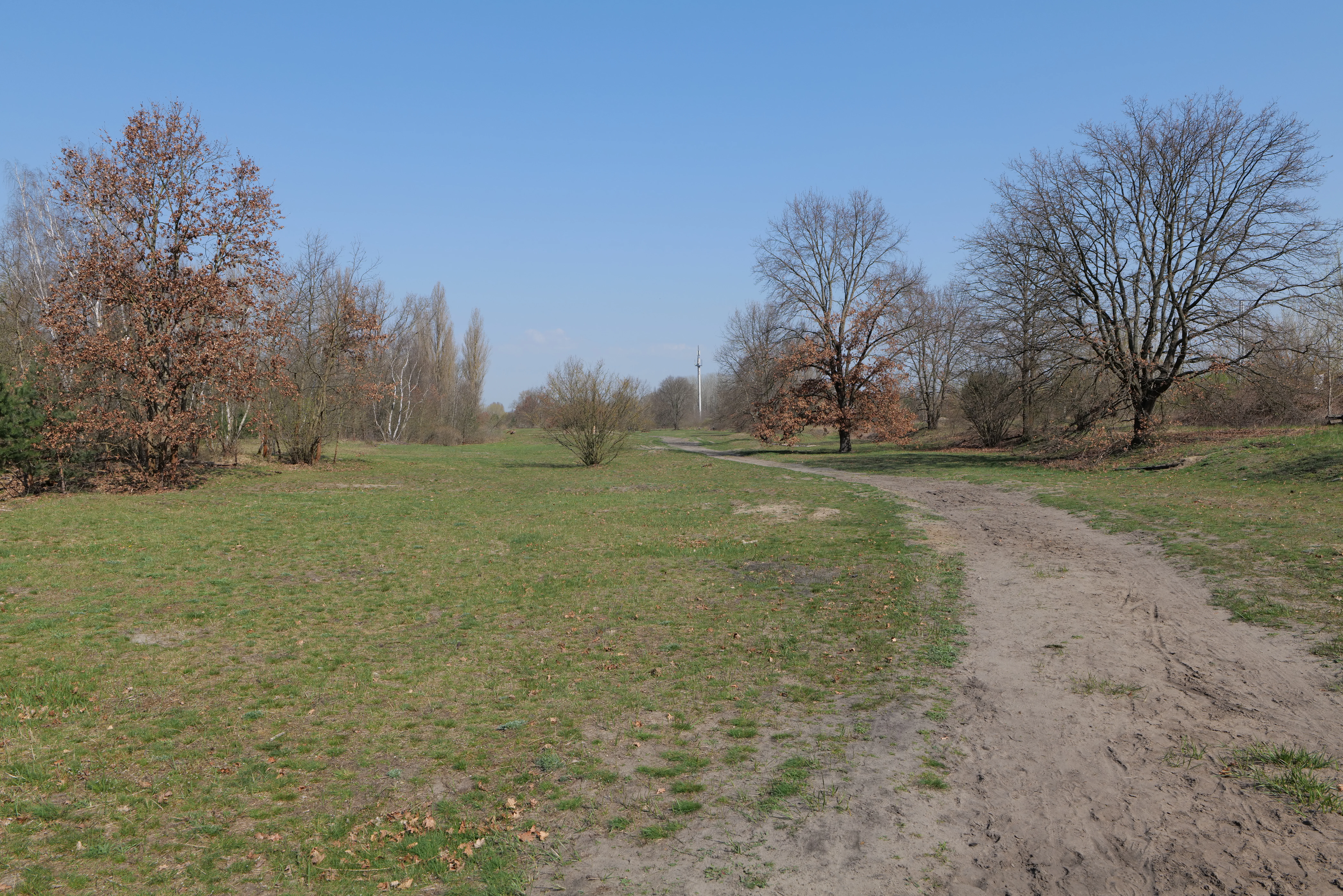
A wide, unpaved dirt path leads into a grassy, sandy landscape dotted with leafless and lightly leaved trees under a clear blue sky.
A dirt trail winds through the sandy meadows and sparse trees of Biesenhorster Sand nature reserve.

Biesenhorster Sand history and protected-area timeline

The landscape of Biesenhorster Sand was originally shaped during the ice age, when the Warsaw-Berlin Urstromtal filled with up to ten meters of glacial meltwater sand, creating the broad sand plain that dominates the area today. The original woodland cover was cleared in the mid-19th century, and the cleared land was used for agriculture for several decades.

In the early 20th century, the site took on a military-airfield character. From 1907, the area hosted a Siemens airship hangar, and from 1917 onward it was part of the Berlin-Karlshorst military aviation station. After 1918, parts of the open land were converted into allotments. In the 1930s, these allotments were displaced by the construction of the Berlin outer freight ring railway (Güteraußenring), and additional sand was used to infill land for the surrounding rail infrastructure.

During the GDR era, the site became part of an even larger military-rail complex. The Wuhlheide marshalling yard, in operation since 1953, occupied adjacent land, and a Soviet Army barracks with its own loading yard stood on the site itself. Withdrawals of Soviet troops in 1994 ended the military use, and in the same year the marshalling yard was decommissioned and its installations gradually dismantled. Since then, the open ground has developed largely undisturbed, although traces of its past use, including the ruin of a repair hall, are still visible.

Conservation efforts began in the mid-1990s under the leadership of NABU Berlin, which has since carried out ongoing management work, including grazing with sheep and goats in five paddocks, to keep the dry grassland open and prevent it from being overgrown by shrubs. As early as 2000, conservationists recommended protecting the green corridor between the Biesdorf interchange in the north and the Wuhlheide in the south as a landscape protection area, and the Lichtenberger dry-grassland sections were specifically proposed as a nature reserve. Almost two decades later, on 18 March 2021, Biesenhorster Sand officially became a Naturschutzgebiet, formalizing the protection that years of voluntary management had already built up on the ground.

Biesenhorster Sand landscape and geographic character

The landscape of Biesenhorster Sand is dominated by a flat, sandy outwash plain of glacial origin. The site sits in the Warsaw-Berlin Urstromtal, where ice-age meltwater once deposited thick layers of sand that today reach up to ten meters deep in some places. This geological foundation gives the reserve its defining character: broad, open, well-drained sandy soils that naturally resist forest colonization.

The most visually distinctive feature is a wide belt of dry grassland (Trockenrasen), in places up to 450 meters across, interspersed with areas of completely bare sand. Within this open matrix, scattered tree groups, tall herb patches, and individual shrubs break up the otherwise exposed sandy ground. The result is a mosaic of open sand, dry grassland, and sparse woody cover, an unusual sight in the densely built-up eastern districts of Berlin.

The sand surfaces reach extreme temperatures in summer, heating up to around 65 degrees Celsius under direct sun. These conditions create a near-steppe microclimate that is rare so far north and is central to the site's ecological identity. The fragmented relicts of industrial and military infrastructure still on the land, including the ruin of a former repair hall, are part of the visible landscape and are slowly being absorbed into the recovering habitat.

Biesenhorster Sand ecosystems, habitats, and plant life

Biesenhorster Sand is ecologically defined by its dry grassland and open sand habitat complex, a habitat type that has become very rare in Berlin. The reserve's ecosystem is built on shallow, nutrient-poor, sandy soils that hold little water and favor light-demanding, drought-adapted species rather than woodland.

The vegetation mosaic combines extensive dry grassland, completely open sand patches, scattered trees, tall herb fringes, and solitary shrubs. This habitat diversity is unusually high for such a compact site and is the foundation of its biological richness. Botanists have documented 382 fern and flowering plant species in the reserve, a remarkable density that reflects the wide range of small-scale habitat conditions present across the open sand plain.

The combination of open sand and dry grassland supports a wide range of ecological niches, from warm, exposed sand surfaces for ground-nesting insects and reptiles, to grassy tussocks for grasshoppers and moths, to scattered shrubs and small trees for nesting birds. Conservation management actively seeks to maintain this openness: grazing with sheep and goats and other maintenance work keeps encroaching woody growth in check, ensuring the open character that makes the site valuable.

Biesenhorster Sand wildlife and species highlights

The wildlife of Biesenhorster Sand is dominated by invertebrates and open-land bird and reptile species tied to dry sandy habitats. Entomological surveys have recorded 1,324 insect species on the site, including 388 macro-moth species, of which 111 are classified as threatened on regional Red Lists. Twelve of these insect species had previously been regarded as extinct in Berlin, and at least one of the weevils found there had not been recorded in Berlin and Brandenburg for over a century. One wild bee species had not been seen in the region since 1912. The reserve also supports 25 grasshopper species, including the Italian locust (Calliptamus italicus) and the largest Berlin population of the blue-winged sand grasshopper (Sphingonotus caerulans).

Beetles are also exceptionally well represented, with 778 documented beetle species, roughly 20 percent of all species known from Berlin and Brandenburg. Around 8 percent of these beetles are on Berlin's Red List.

The hot, exposed sand surfaces are important habitat for reptiles, especially the strictly protected sand lizard (Lacerta agilis), which finds ideal basking and nesting conditions on the dry grassland and open sand. The reserve is also recognized as a breeding area for 33 bird species, with a clear emphasis on open-land and ground-nesting birds. Notable breeding species include the tawny pipit, crested lark, woodlark, northern wheatear, red-backed shrike, and common linnet, all of which are Red List species in Germany.

Biesenhorster Sand conservation status and protection priorities

Biesenhorster Sand is a conservation priority because it safeguards one of the last and most species-rich dry grassland and open sand ecosystems in Berlin, a habitat type that has been almost entirely lost from the surrounding cityscape. Its official designation as a Naturschutzgebiet (nature reserve) on 18 March 2021 confirmed decades of informal protection and gave the site a formal legal status. The reserve is managed to maintain its open character through ongoing grazing and mowing.

The site's conservation value lies primarily in its biodiversity density. Despite covering only about 42.9 hectares and being fully enclosed by railways, urban infrastructure, and allotments, it hosts 382 plant species, 1,324 insect species, 778 beetle species, and 33 breeding bird species, including multiple Red List and nationally protected species and several rediscoveries of species previously thought extinct in the region. The reserve thus serves as a critical refuge for species that depend on habitats that Berlin has otherwise lost to urbanization.

Conservation management is led by NABU Berlin, which has worked on the site since the mid-1990s through a formal Pflege- und Entwicklungsplan (management and development plan). Management tools include grazing with sheep and goats across five paddocks, along with manual interventions, all aimed at keeping the dry grassland open and preventing shrub encroachment. The reserve also functions as a local recreational area, with a network of paths that allow visitors to experience the habitat without compromising its conservation goals.

Biesenhorster Sand cultural meaning and human context

The cultural history of Biesenhorster Sand is shaped by layers of 20th-century industrial and military use, followed by a deliberate return to nature. The site was cleared of its original woodland in the 19th century, used as farmland, then converted into airship and aviation infrastructure by Siemens and the German military in the early 20th century. After the Second World War and during the GDR period, it lay within a large Soviet military and railway complex that included the Wuhlheide marshalling yard and a Soviet barracks with its own loading facility.

The departure of Soviet troops in 1994 and the closure of the marshalling yard in the same year created an abrupt end to nearly a century of intensive land use and opened the door to a new ecological identity for the area. Current cultural relevance is strongly tied to nature conservation: NABU Berlin has framed the site as both a local nature experience area (Naherholung) and an example of successful urban-industrial land recovery, with walking paths, information boards at entrances, and guided visits connecting the reserve to broader public engagement with biodiversity in the city.

Top sights and standout views in Biesenhorster Sand

Biesenhorster Sand stands out as a compact but ecologically dense urban nature reserve, where a glacial sand plain supports dry grassland, open sand, scattered trees, and tall herb vegetation in the middle of eastern Berlin. It is notable for rediscoveries of plant and insect species long thought extinct in Berlin, including a plant previously considered lost from the city and at least one insect species unseen in the region for over a century.

Equally distinctive is its conservation story: decades of work by NABU Berlin, supported by sheep and goat grazing, transformed a former military and railway site into a formal nature reserve in 2021. The result is a small but biologically rich protected area combining geological heritage, threatened species recovery, and active habitat management within an intensively used urban landscape.

Best time to visit Biesenhorster Sand

Spring and early summer are generally the most rewarding seasons to experience Biesenhorster Sand, when dry grassland plants are in bloom, many insects are active, and breeding birds are present, including species like the tawny pipit, woodlark, and northern wheatear that depend on the open sandy habitat. Visits in late spring also tend to feature milder temperatures compared with the deep summer, when exposed sand surfaces can heat to extreme levels.

Late summer and early autumn remain interesting for insect and grasshopper sightings, though the heat of open sand areas is at its peak and reptiles such as sand lizards are most easily observed in warmer conditions. In winter, the open character of the site is most visible; vegetation dies back and the structure of the glacial sand plain, dry grassland strips, and scattered trees becomes the dominant visual impression.

Monthly climate preview

Long-term representative monthly averages for temperature and precipitation

Biesenhorster Sand Climate Normals and Annual Temperature Patterns

Historical data recorded at the Biesenhorster Sand coordinate reveals a measured annual rhythm of changing monthly temperatures and daily precipitation rates. Examining the full twelve-month profile provides deeper context for long-term climatic variations across the protected area.
Annual mean9 °C
-1 °C20 °C
Jan-1°
Feb
Mar
Apr
May14°
Jun18°
Jul20°
Aug20°
Sep15°
Oct
Nov
Dec
Warmest month
July

20.3 °C

Coolest month
January

-0.9 °C

Wettest month
July

2.4 mm/day

Driest month
April

1.1 mm/day

Park location guide

Geography guide, regional context, and park location map for Biesenhorster Sand

Biesenhorster Sand park geography, regions, and map view in Germany

Understand where Biesenhorster Sand sits in Germany through a broader geographic reading of the surrounding landscape, nearby location context, and its mapped position within the national park landscape.

How Biesenhorster Sand fits into Germany

Germany is a federal republic in Western and Central Europe with a population of over 83 million across sixteen constituent states. It is Europe's largest economy by nominal GDP and a major global exporter and importer. The capital is Berlin, and the country borders Denmark, Poland, Czech Republic, Austria, Switzerland, France, Luxembourg, Belgium, and the Netherlands.

Wider geography shaping Biesenhorster Sand in Germany

Germany is located in Western and Central Europe, spanning 357,022 km². It borders Denmark to the north, Poland and the Czech Republic to the east, Austria and Switzerland to the south, and France, Luxembourg, Belgium, and the Netherlands to the west. The country has coastlines on the Baltic Sea and North Sea to the north, with the Alps located in the southern region.

Map view of Biesenhorster Sand

Use this park location map to pinpoint Biesenhorster Sand in Germany, understand its exact geographic position, and read its mapped placement within the surrounding landscape more clearly.

Pigeon | © OpenStreetMap contributors

Location context for Biesenhorster Sand

Berlin

Visual exploration of glacial sand terrain and dry grassland habitats

Biesenhorster Sand Photos, Scenery, and Protected Landscape Views

Visual documentation captures the open sandy terrain, dry grassland mosaics, and rare habitats defining Biesenhorster Sand. Examining these protected area photographs reveals the distinctive glacial geology and urban reserve scenery found across the outwash plain.

A wide, unpaved dirt path leads into a grassy, sandy landscape dotted with leafless and lightly leaved trees under a clear blue sky.

Park atlas

Compare adjacent glacial landscapes, dry grasslands, and urban nature reserves

Explore Parks Near Biesenhorster Sand and Surrounding Regional Protected Areas

Visitors exploring Biesenhorster Sand can continue browsing other nearby protected areas and urban nature reserves across the surrounding region. Expanding the geographic comparison reveals connected glacial sand outwash plains, dry grassland habitats, and regional conservation landscapes.
Watercolor painting of a rolling landscape with green grass, bushes, and soft-colored hills in the background.
Protected landscapeBerlin
About 3.2 km away#1 closest

East

Kaulsdorfer Seen: A Protected Landscape in Berlin with Glacial and Industrial History

Exploring the groundwater protection zones and post-mining lakes of eastern Berlin

The Kaulsdorfer Seen area represents a distinct protected landscape located in Berlin. It showcases the transition between ice-age glacial regions, featuring two prominent lakes that evolved from sand and gravel pits into a mature ecosystem of willow thickets, woodland, and reeds. This site functions as an important drinking-water protection zone, offering a structured look at the complex interplay between urban development and natural resource conservation.

Area
0.937 km²
Water
Major water bodies
Nature reserveBerlin
About 6.2 km away#2 closest

Southwest

Wasserwerk Johannisthal Nature Reserve: Mapping Berlin's Industrial and Hydrological Landscape

A protected urban groundwater zone in Treptow-Köpenick.

Explore the unique geography of Wasserwerk Johannisthal, a nature reserve in Berlin that balances industrial heritage with modern environmental management. This thirty-five-hectare site offers insights into urban protected areas, showing how historic water infrastructure is now secured for groundwater monitoring and remediation, set against the backdrop of the city's complex transport and green-space network.

Area
0.35 km²
Established
2007
IUCN
IV
Relief
Lowland
Nature reserveBerlin
About 7 km away#3 closest

North

Unkenpfuhle Marzahn Nature Reserve: Geographic Context and Protected Landscape Map

Urban amphibian habitat in Berlin, Germany

Unkenpfuhle Marzahn is a protected nature reserve spanning over three hectares of glacial moraine terrain in Berlin. The site provides a critical haven for threatened amphibians, featuring a unique combination of wetland ponds, reedbeds, and dry grassland habitats tucked between urban and cemetery zones.

Area
0.033 km²
Established
2001
IUCN
IV
Scope
Terrestrial
Protected landscapeBerlin
About 9.2 km away#4 closest

Southwest

Vogelschutzgebiet am Wildmeisterdamm in Rudow: Berlin Urban Protected Woodland Map

Historical bird sanctuary and broadleaf landscape in Neukölln

Spanning roughly 3.75 hectares in the Gropiusstadt district, this site functions as an important refuge for urban birdlife amidst dense residential development. The woodland features a mix of oak, birch, and elm trees, preserved for their ecological continuity since the site first gained official protection in the early twentieth century.

Area
0.038 km²
Established
1934
IUCN
V
Relief
Lowland
Nature reserveBerlin
About 9.4 km away#5 closest

Southeast

Teufelsseemoor Köpenick: Protected Kettle Bog Geography and Urban Wetland Atlas

Glacial landscape and conservation zone in Berlin, Germany

Teufelsseemoor Köpenick is a key nature reserve in Berlin that showcases the transition from post-glacial kettle hole to a thriving peatland and swamp forest. This protected area stands out for its ecological gradient and serves as a model of urban wilderness conservation. The site is defined by the contrast between its still waters and the surrounding moraine ridges of the Müggelberge.

Area
0.065 km²
Established
2016
IUCN
IV
A watercolor painting of a flat, marshy landscape with soft green trees in the midground and pale hills under a light sky in the background.
Nature reserveBerlin
About 9.7 km away#6 closest

North

Falkenberger Rieselfelder Nature Reserve: A Detailed Atlas of Berlin Protected Lands

Reclaimed wetland geography and urban conservation habitats

Falkenberger Rieselfelder acts as an ecologically rich refuge where former industrial irrigation fields have been repurposed into a mosaic of seasonal pools and meadows. Located on the urban fringe of Berlin, this nature reserve offers a unique look at how conservation grazing and habitat management support species like the great crested newt within a dense metropolitan region.

Area
0.881 km²
Established
1995
IUCN
IV
Relief
Lowland
A watercolor painting showing a soft, abstract landscape with rolling hills, a central body of water, and a tree-lined shoreline.
Nature reserveBerlin
About 9.7 km away#7 closest

Southeast

Krumme Lake Nature Reserve: Geographic Overview and Protected Wetland Boundaries in Berlin

A preserved mosaic of alder swamp forest and Dahme floodplain habitat

Krumme Lake preserves a dense network of wetland habitats within the pine-dominated forests of Berlin's Treptow-Köpenick borough. This protected nature reserve integrates groundwater-influenced ecosystems and riparian forest remnants, providing a sanctuary for diverse amphibians and invertebrates that have become increasingly rare in surrounding urbanized landscapes.

Area
0.452 km²
Established
2004
IUCN
IV
Relief
Lowland
Watercolor painting of a peaceful wetland landscape with lush green trees, reeds, and soft hills in the background under a light sky.
Nature reserveBerlin
About 11 km away#8 closest

North

Malchower Aue Nature Reserve: A Detailed Atlas of Urban Protected Landscapes in Berlin

Wetland habitats and glacial terrain within the Berlin city limits.

Malchower Aue stands as a protected enclave of wetland diversity featuring a system of reed-fringed peat-cutting ponds, wet meadows, and rare dry-grassland vegetation on historical soil mounds. This site provides a vital geographic perspective on how post-glacial relief and human land-use history shape protected areas within the modern urban landscape of Berlin.

Area
0.222 km²
Established
1995
Relief
Lowland
Climate
Temperate

Common questions about visiting, size, designation, and location context for Biesenhorster Sand

Biesenhorster Sand FAQs for park facts, access, geography, and protected area context

Find quick answers about Biesenhorster Sand, including protected-area facts, park geography, trail and visitor context, and how the park fits into its surrounding country and regional landscape.
MoriAtlas Explorer

Continue Your Protected Areas Search Across the Global Atlas

Deepen your exploration by continuing the structured search for national parks and protected areas worldwide. Utilize the comprehensive filtering capabilities to compare different conservation landscapes and refine your understanding of global park geography. Discover more about the distribution and characteristics of protected natural areas.

Global natural geography