Mori Atlas logo
Nature reserveBiotopo Prati di Monte

Examining the ecological geography and porphyritic terrain of the Dossone di Cembra ridge

Biotopo Prati di Monte: A Documented Nature Reserve and Protected Alpine Wetland Mosaic

Biotopo Prati di Monte protects a critical mosaic of rare alpine habitats situated on the porphyritic Dossone di Cembra ridge in the Trentino-Alto Adige region of northern Italy. This nature reserve serves as a sanctuary for boreal relict flora and specialized peatland ecosystems, including the glacial-origin Lago di Valda. The protected landscape spans acidic spruce forests, sphagnum-dominated bogs, and wet meadows, providing an essential geographic record of high-altitude wetland succession.

biotopeprotected areapeat bogtorbieraalpine wetlandLago di Valda

Biotopo Prati di Monte

Nature reserve

Park overview

Structured park overview, official facts, and landscape profile for Biotopo Prati di Monte

Biotopo Prati di Monte park facts, protected area profile, and essential visitor context

Review the core facts for Biotopo Prati di Monte, including designation, size, terrain, visitor scale, habitats, and operating context in one park-focused overview.

About Biotopo Prati di Monte

Biotopo Prati di Monte lies on the Dossone di Cembra, a porphyritic ridge in the southeastern portion of Trentino that forms a clear geographical divide between the deeply cut Val di Cembra to the north and the warmer Bassa Atesina wine country to the south. The protected area occupies the higher, cooler part of this ridge, where the geology, the substrate chemistry, and a long history of waterlogging have combined to produce one of the most distinctive wetland complexes in the province of Trento.

The focal point of the biotope is the Lago di Valda, a small glacial basin that still retains a reduced open-water surface but is rimmed and increasingly dominated by peat-forming vegetation. Intensive drainage in earlier decades turned much of the surrounding ground into pasture, but environmental restoration work carried out under the European rural development program (PSR) has helped re-establish part of the original wetland hydrology. What visitors and researchers encounter today is essentially a recovering bog system set against a backdrop of acidic spruce forest and mountain meadow.

Ecologically, the biotope is unusually rich for its modest footprint. Since its designation in 1994, the area has been documented as a host to six natural habitat types of Community interest under the European Union Habitats Directive, and it is also classified as a Zona Speciale di Conservazione. The combination of acidic peat substrates, cold air drainage, and the higher elevation of the Dossone di Cembra creates conditions that allow cold-adapted, often boreal plant species to persist in a region otherwise dominated by warmer Alpine and sub-Mediterranean landscapes.

Quick facts and research context for Biotopo Prati di Monte

Biotopo Prati di Monte is a regional protected biotope in northern Italy, located in Altavalle in the province of Trento, Trentino-Alto Adige. It was formally established in 1994 through a provincial decree and is managed by the Rete di Riserve Val di Cembra Avisio. The area covers approximately 5,988 hectares of land and is classified internationally as an IUCN Category IV area, focused on the conservation of specific habitats and species. At its center sits the Lago di Valda, a small glacial lake on the porphyritic Dossone di Cembra ridge that has largely given way to peat-forming wetlands.

Protection and recognition

Examine official protected area records and international database entries for Biotopo Prati di Monte.

Biotopo Prati di Monte Protection Status and Conservation Records

Biotopo Prati di Monte maintains a documented protection status within global conservation databases and spatial registries. Official records compile verified protected area data to support ongoing environmental research and regional geographic analysis.

Protection details

WDPA ID
178811
Park context

Deeper park guide and search-rich context for Biotopo Prati di Monte

Biotopo Prati di Monte history, landscape, wildlife, and travel context

Explore Biotopo Prati di Monte through its history, landscape character, ecosystems, wildlife, conservation priorities, cultural context, and seasonal travel timing in a structured park guide built for atlas discovery and search intent.

Why Biotopo Prati di Monte stands out

The site is best known for its concentrated mosaic of peatland habitats, including active raised bogs with sphagnum moss, wooded bogs, acidic spruce forest (pecceta), and specialized wet meadows, all packaged within a small area on an Alpine ridge. It also stands out for harboring several highly localized boreal and sub-arctic relict plant species on the southern edge of the Alps, making the bog a documented refuge for flora that is otherwise exceptionally rare in the region.
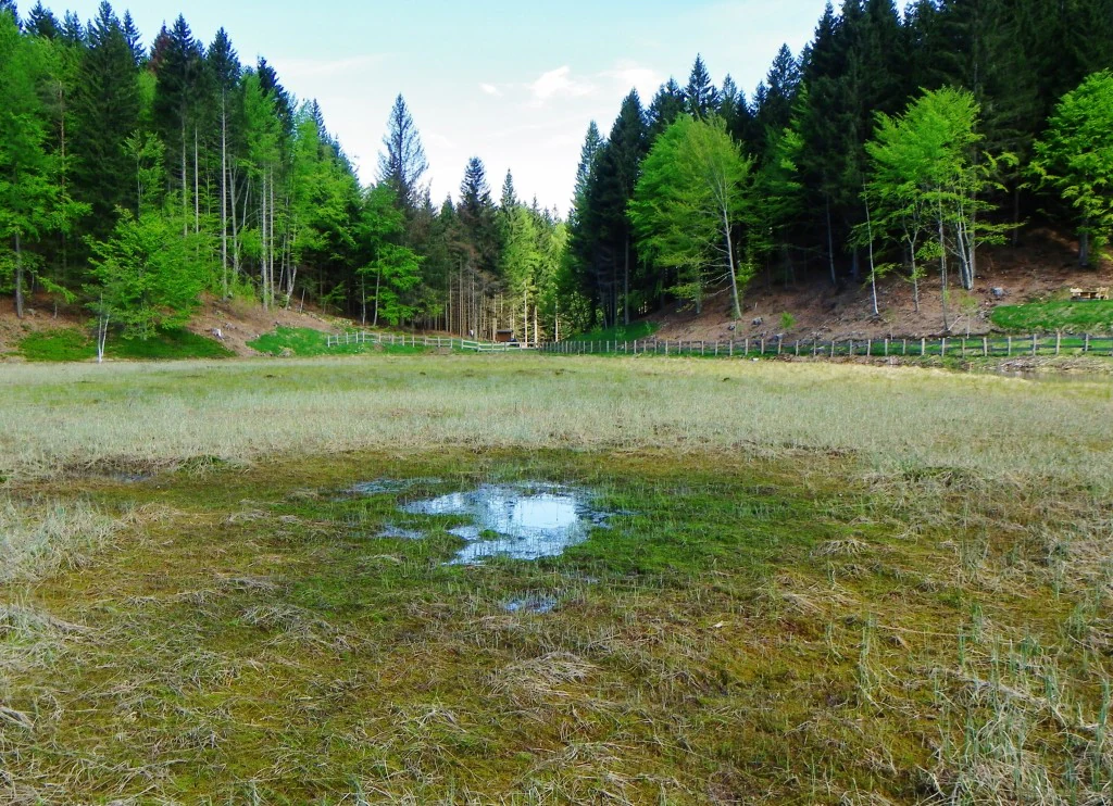
A wide view of a small pond surrounded by dry marshy grasses, with a dense forest of evergreen and deciduous trees in the background.
A view of the wetland and marshy terrain at Lago di Valda in Biotopo Prati di Monte.

Biotopo Prati di Monte history and protected-area timeline

Before its formal protection, the Lago di Valda basin had been substantially drained through a network of canals that lowered the water table and converted large areas of peatland into pasture. This drainage reduced the open lake to a remnant and disrupted the bog vegetation that had historically characterized the site.

The area was formally established as a protected biotope in January 1994 by a provincial decree (D.G.P. 281, 18.01.94), as part of the broader provincial network of small-scale natural reserves in Trentino. In the years following designation, environmental restoration initiatives supported under the European agricultural fund for rural development (PSR) worked to reverse some of the earlier drainage and to rehabilitate part of the original bog environment, giving the wetland a renewed ecological coherence. The area is now managed within the Rete di Riserve Val di Cembra Avisio, a coordinated network of reserves in the Cembra valley.

Biotopo Prati di Monte landscape and geographic character

The biotope occupies a high, relatively exposed setting on the Dossone di Cembra, a mountain ridge formed from porphyritic rock that gives the surrounding terrain a distinctive reddish mineral character. This geology, combined with the ridge's elevation and its position between two contrasting valleys, produces a landscape that is colder and more acidic than the lower slopes of the surrounding region.

The physical environment is defined less by dramatic relief than by the contrast between soft, waterlogged ground and firmer upland terrain. Open peatland, damp meadows, and boggy depressions alternate with patches of confier-dominated bog woodland and acidophilic spruce forest, producing a mosaic of subtly different habitats rather than a single sweeping vista. The partially reclaimed Lago di Valda lies at the heart of this mosaic, with its relict open-water surface surrounded by encroaching bog vegetation.

Biotopo Prati di Monte ecosystems, habitats, and plant life

Biotopo Prati di Monte is defined ecologically by its peatland habitats. The site contains six natural habitat types recognized as being of Community interest under the European Habitats Directive, including active raised bogs with sphagnum moss, wooded bogs where coniferous and broadleaved trees grow on peat substrate, depressions on peaty substrates, Molinia meadows on calcareous clay soils (Eu-Molinion), Nardus grasslands, and acidophilic spruce forest (pecceta).

This habitat diversity reflects the site's transitional position. Cool, acidic bog environments sit alongside patches of calcareous-influenced wet meadow, creating a tension between floristic elements that more often occur in isolation elsewhere in the Alps. The bog substrates, in particular, support a community of cold-adapted plant species that are biologically far more typical of northern boreal landscapes than of the central Alps.

Biotopo Prati di Monte wildlife and species highlights

The protected area's wildlife profile is shaped by its wetland and bog habitats. The damp ground and shallow remnant lake support amphibian species such as the alpine newt (Tritone alpestre), the Alpine frog (Rana di montagna), and the common toad (Rospo comune), along with a varied invertebrate community associated with the peatland.

The surrounding spruce forest and bog woodland add a forest-dependent faunal layer, and the high botanical value of the site reinforces its importance for conservation of associated invertebrate and micro-habitat specialists that depend on the bog flora.

Biotopo Prati di Monte conservation status and protection priorities

The biotope's principal conservation significance lies in the survival, in the heart of the Alps, of a coherent raised bog and associated acid mire system that has been heavily reduced across much of Europe. The site is recognized internationally as an IUCN Category IV protected area (habitat/species management area) and is listed as a Zona Speciale di Conservazione under the European Union's Natura 2000 framework, reflecting the presence of multiple Annex I habitat types.

Active restoration, including hydrological rehabilitation supported through rural development programs, has been central to the site's conservation story, addressing past drainage damage and helping the bog vegetation recover. The site's management within the Rete di Riserve Val di Cembra Avisio places it within a broader coordinated effort to protect and connect natural areas across the Cembra valley landscape.

Biotopo Prati di Monte cultural meaning and human context

The Cembra valley has a long history of mountain agriculture and small-scale land use, and the pasturing pressure that once drained the Lago di Valda reflects the valley's broader pattern of human use of high ground for livestock. The current protected status represents a shift in regional land-use priorities toward conserving wetland habitats that, on a continental scale, are far rarer than the agricultural landscapes that replaced them.

Top sights and standout views in Biotopo Prati di Monte

The Lago di Valda, with its partially restored glacial basin set within the porphyritic Dossone di Cembra, is the visible center of the biotope; around it, a dense mosaic of raised bog, wooded bog, Molinia meadows, Nardus grassland, and acidophilic spruce forest makes the area ecologically striking despite its small size. Six Annex I habitat types within a single protected zone, combined with the presence of rare sub-arctic relict flora, place the site among the more significant small-scale protected areas in Trentino.

Best time to visit Biotopo Prati di Monte

Late spring and early summer tend to be the most rewarding periods, when the bog vegetation is actively growing, sphagnum and cottongrass-like species are most visible, and amphibian activity around the wetland margins is high. Summer visits offer the warmest conditions and the widest window for walking the open terrain, while early autumn can bring clearer views across the surrounding valleys and a quieter atmosphere. Winter visits are possible at the broader landscape scale but should take into account that the wetland ground and surrounding alpine terrain can become inhospitable due to cold, snow, and difficult footing.


Monthly climate preview

Long-term annual temperature curves and precipitation rates sampled at representative park coordinates

Biotopo Prati di Monte Climate Normals and Measured Temperature Ranges

Representative coordinate measurements record monthly mean temperatures spanning negative values up to 17.67 degrees Celsius alongside precipitation rates fluctuating between 1.17 and 3.53 millimeters per day. Examining the comprehensive monthly climate profile allows researchers to trace complete multi-year weather normals and precipitation variations across the protected landscape.
Annual mean7 °C
-3 °C18 °C
Jan-3°
Feb-1°
Mar
Apr
May11°
Jun15°
Jul18°
Aug18°
Sep13°
Oct
Nov
Dec-2°
Warmest month
July

17.7 °C

Coolest month
January

-3 °C

Wettest month
October

3.5 mm/day

Driest month
January

1.2 mm/day

Park location guide

Geography guide, regional context, and park location map for Biotopo Prati di Monte

Biotopo Prati di Monte park geography, regions, and map view in Italy

Understand where Biotopo Prati di Monte sits in Italy through a broader geographic reading of the surrounding landscape, nearby location context, and its mapped position within the national park landscape.

How Biotopo Prati di Monte fits into Italy

Italy is a unitary parliamentary republic in Southern and Western Europe, located on the Italian Peninsula with the Alps to the north. It borders France, Switzerland, Austria, Slovenia, Vatican City, and San Marino, and shares maritime boundaries with several Mediterranean countries. The country has approximately 59 million residents and uses the Euro as its currency.

Wider geography shaping Biotopo Prati di Monte in Italy

Italy occupies a boot-shaped peninsula in southern Europe, bordered by the Alps to the north. It shares land borders with France, Switzerland, Austria, Slovenia, Vatican City, and San Marino. The country includes the Mediterranean islands of Sicily and Sardinia, along with approximately 800 smaller islands.

Map view of Biotopo Prati di Monte

Use this park location map to pinpoint Biotopo Prati di Monte in Italy, understand its exact geographic position, and read its mapped placement within the surrounding landscape more clearly.

Pigeon | © OpenStreetMap contributors

Location context for Biotopo Prati di Monte

Trentino-Alto Adige

Visualizing the peat bogs, glacial lakes, and alpine habitats of northern Italy

Biotopo Prati di Monte Photos and Landscape Scenery Exploration

Visual records capture the distinctive terrain, wetland mosaic, and protected environments of Biotopo Prati di Monte. Detailed photography reveals the rare alpine habitats and glacial water features defining this northern Italian mountain reserve.

A wide view of a small pond surrounded by dry marshy grasses, with a dense forest of evergreen and deciduous trees in the background.

Park atlas

Compare nearby mountain ridges, glacial wetlands, and regional protected landscapes

Exploring Parks Near Biotopo Prati di Monte and Surrounding Alpine Protected Areas

Browse other parks near Biotopo Prati di Monte to evaluate connected alpine habitats, high-altitude wetlands, and porphyritic terrain across the surrounding region. Comparing adjacent protected landscapes provides deeper context on regional flora distributions and localized conservation zones.
A horizontal watercolor painting showing a meadow-like bog landscape with light green and yellow ground cover, scattered small trees, and a background of rolling hills and forested ridges in shades of green and soft pink.
Nature reserveTrentino-Alto Adige
About 12 km away#1 closest

Northeast

Biotopo Palù Longa Nature Reserve: Mapped Peatland and Alpine Geography in Trentino-Alto Adige

Protected watershed habitat featuring Sphagnum moss and diverse alpine plant communities

Located in the Trentino-Alto Adige region, Biotopo Palù Longa is a protected nature reserve defined by its rare Alpine peatland character. The area encompasses 6 hectares of wetland, including open bog pools, wet meadows, and sedge-dominated terrain. This site offers valuable insight into the ecological preservation of fragile mountain microhabitats, illustrating the intersection of forested slopes and historic peat-forming basins.

Area
0.061 km²
Established
1987
Relief
Highland
Climate
Alpine
Nature reserveTrentino-Alto Adige
About 27 km away#2 closest

Southwest

Torbiera delle Viote Nature Reserve: Alpine Wetland Plateau Geography and Protected Boundaries

A high-elevation peat bog enclave within the Monte Bondone mountain landscape

Situated on the Piana delle Viote in the Trentino-Alto Adige region, this nature reserve protects a rare alpine peat bog ecosystem. The site functions as a unique wetland basin framed by dense conifer forests, offering significant insight into high-altitude hydrology, amphibian habitats, and the specific terrain features that define this protected mountain landscape.

Area
0.13 km²
Established
2003
A horizontal watercolor illustration depicting a lake framed by green rolling hills and distant purple mountain ridges.
Nature reserveTrentino-Alto Adige
About 29 km away#3 closest

Southwest

Biotopo Lago di Toblino Protected Area and Regional Landscape Geography

Nature reserve featuring Alpine and sub-Mediterranean plant habitats

Biotopo Lago di Toblino acts as a sheltered basin where lake, marsh, and woodland habitats create an essential corridor for wildlife. This protected landscape is shaped by the interplay between the surrounding steep mountains and the influence of nearby Lake Garda, fostering an unusual climatic overlap that supports a wide range of native flora and waterbird populations within an important European conservation site.

Area
1.705 km²
Established
1992
IUCN
IV
Soft watercolor painting of layered green hills and distant mountain ranges with a hazy, light-filled sky.
Nature reserveTrentino-Alto Adige
About 35 km away#4 closest

Southwest

Biotopo Marocche di Dro: Geologic Protected Landscape in Trentino-Alto Adige

Discover the massive postglacial rockfall deposits of northern Italy.

Biotopo Marocche di Dro is a protected nature reserve defined by its expansive, boulder-strewn arid surface and exceptional postglacial rockslide deposits. Unlike typical wetland biotopes, this site provides a rare, sun-exposed habitat for reptile-rich fauna and unique plant communities within the broader Trentino landscape, offering a window into the dramatic geological transformations that have shaped the valley floor.

Area
2.508 km²
Established
1989
IUCN
IV
Watercolor painting of a mountain range with a lake, green hills, and a sunset sky
National parkTrentino-Alto Adige/Südtirol
About 38 km away#5 closest

Northwest

Stelvio National Park National Park: Protected Landscape and Regional Geographic Context

Explore its mapped boundaries and natural terrain.

Navigate Stelvio National Park, a designated national park in Italy's Trentino-Alto Adige/Südtirol region, through a map-centric lens. This page provides critical context for understanding the park's protected landscape, its geographic position within the Alps, and its mapped terrain. Utilize MoriAtlas to grasp the park's boundaries and its place in regional geography for structured natural landscape discovery.

Established
1935
IUCN
II
Relief
Mountain
Scope
Terrestrial
Nature reserveTrentino-Alto Adige
About 40 km away#6 closest

Southwest

Biotopo Lomasona Nature Reserve: Protected Landscapes and Alpine Geography in Trentino

A small-scale conservation area in the heart of Val Lomasona

Biotopo Lomasona stands as a specialized nature reserve in the Italian Province of Trento. This compact protected area focuses on habitat conservation within the alpine terrain, serving as an important ecological anchor in the valley landscape of Comano Terme and the wider Trentino-Alto Adige region.

Area
0.26 km²
Established
1987
IUCN
IV
A watercolor painting showing a panoramic view of a green wetland landscape with soft purple mountains in the background.
Nature reserveTrentino-Alto Adige
About 41 km away#7 closest

Southwest

Biotopo Fiavé: A Protected Wetland and Archaeological Landscape in Trentino-Alto Adige

Mapping glacial lake basins and ancient prehistoric heritage sites

Located at the foot of Monte Cogorna, Biotopo Fiavé functions as a vital wetland reserve characterized by extensive peat bogs and mixed willow-alder thickets. This area offers a unique intersection of natural hydrological evolution and UNESCO-protected archaeological history, serving as a rare, compact cross-section of alpine valley ecosystems and prehistoric human settlement patterns.

Area
1.373 km²
Established
1988
IUCN
IV
Watercolor illustration showing a mountainous landscape with a waterfall, green hills, and layered colors
National parkProvince of Belluno
About 43 km away#8 closest

East

Dolomiti Bellunesi National Park: National Park, Province of Belluno Protected Landscape

Explore mapped boundaries and regional geography

This entry details Dolomiti Bellunesi National Park, a distinct national park situated within the Province of Belluno. It provides essential geographic context and protected landscape information, enabling users to understand the park's boundaries and its role within the regional terrain. Dive into the mapped features and discover the atlas-driven details of this significant Italian protected area.

Area
32 km²
Established
1988
IUCN
II
Relief
Mountain

Common questions about visiting, size, designation, and location context for Biotopo Prati di Monte

Biotopo Prati di Monte FAQs for park facts, access, geography, and protected area context

Find quick answers about Biotopo Prati di Monte, including protected-area facts, park geography, trail and visitor context, and how the park fits into its surrounding country and regional landscape.
MoriAtlas Explorer

Continue Your Protected Areas Search Across the Global Atlas

Deepen your exploration by continuing the structured search for national parks and protected areas worldwide. Utilize the comprehensive filtering capabilities to compare different conservation landscapes and refine your understanding of global park geography. Discover more about the distribution and characteristics of protected natural areas.

Global natural geography