Mori Atlas logo
Nature reserveBlumberger Pforte und Mittlere Wutach

Analyzing the ecological corridor between the Swabian Alb and the southern Black Forest regions

Blumberger Pforte und Mittlere Wutach: A Protected Gorge and Plateau Landscape in Baden-Württemberg

(FFH-Gebiet Blumberger Pforte und Mittlere Wutach)

Blumberger Pforte und Mittlere Wutach represents a high-value nature reserve defined by the deeply incised Wutach gorge and the surrounding limestone plateaus. The protected area features a compressed mosaic of habitats including ash-lime forest, juniper heaths, and dry grassland. Geologically significant karst structures, including eighteen recorded caves and travertine springs, define the terrain, providing a critical ecological link between the Swabian Alb and the southern Black Forest.

FFH siteHabitats Directivenature reserve mosaicriver gorgeWutach valleySwabian Alb fringe

Blumberger Pforte und Mittlere Wutach

Nature reserve

Park overview

Structured park overview, official facts, and landscape profile for Blumberger Pforte und Mittlere Wutach

Blumberger Pforte und Mittlere Wutach park facts, protected area profile, and essential visitor context

Review the core facts for Blumberger Pforte und Mittlere Wutach, including designation, size, terrain, visitor scale, habitats, and operating context in one park-focused overview.

About Blumberger Pforte und Mittlere Wutach

Blumberger Pforte und Mittlere Wutach is a European Habitats Directive site that focuses on a particularly species-rich transition zone between the Swabian Alb, the Baar, and the southern Black Forest in Baden-Württemberg. The protected area extends along the middle Wutach, where the river has carved a narrow, steep-walled canyon through layers of limestone, creating conditions that support a remarkable concentration of cool, moist gorge forest alongside exposed cliff and scree communities.

The site is administered by the Regierungspräsidium Freiburg and falls administratively within the Naturpark Südschwarzwald. Six municipalities contribute territory to the protected area. The largest share lies within the municipality of Stühlingen, followed by Blumberg, Bonndorf im Schwarzwald, Eggingen, and the small community of Wutach. The geographic center lies near 47.78° N and 8.44° E, roughly between the towns of Donaueschingen upstream and Waldshut-Tiengen downstream where the Wutach eventually leaves the protected landscape.

Ecologically, the protected area is shaped by two clearly different landscape characters. The river valleys and their immediate slopes are dominated by cold-air-adapted gorge forests, ash-sycamore slope forests, and alder floodplain woodland, interspersed with waterfalls, tufa springs, and cave entrances. Upland plateaus in contrast carry extensive calcareous grasslands, juniper heath, mountain hay meadows, and beech forests with orchids, where traditional low-intensity farming has shaped the open habitats over centuries.

The protected mosaic directly overlaps with several smaller nature reserves, including the Wutachflühen cliffs, the Auäcker site, Lindenberg-Spießenberg, Billibuck, and Braunhalden-Schlattboden, which together reinforce the strong conservation focus on dry grasslands, structural habitat complexity, and old-growth forest features. Part of the wider area is also covered by the Wutach und Baaralb bird protection zone under the EU Birds Directive.

Quick facts and research context for Blumberger Pforte und Mittlere Wutach

Blumberger Pforte und Mittlere Wutach is a 6,325-hectare FFH site (code DE-8216-341) in Baden-Württemberg, Germany, lying within the Naturpark Südschwarzwald and straddling the Schwarzwald-Baar-Kreis and Landkreis Waldshut. It centers on the middle course of the Wutach River and includes the famous Wutachschlucht gorge along with adjoining plateau landscapes. The site was formally designated on 11 January 2019 following a regulation issued on 25 October 2018, after an initial nomination in 2004. Portal caves, dry grasslands, juniper heaths, low-intensity hay meadows, and gorge forests are all part of the protected mosaic; 18 caves are recorded within the area.

Protection and recognition

Examining official designation records, management scope, and international listings for Blumberger Pforte und Mittlere Wutach

Blumberger Pforte und Mittlere Wutach Protection Status and Natura 2000 Recognition

Blumberger Pforte und Mittlere Wutach holds documented Natura 2000 recognition records within global protected area databases. Reviewing these official entries provides clear insight into international conservation designations associated with the terrain.
Park context

Deeper park guide and search-rich context for Blumberger Pforte und Mittlere Wutach

Blumberger Pforte und Mittlere Wutach history, landscape, wildlife, and travel context

Explore Blumberger Pforte und Mittlere Wutach through its history, landscape character, ecosystems, wildlife, conservation priorities, cultural context, and seasonal travel timing in a structured park guide built for atlas discovery and search intent.

Why Blumberger Pforte und Mittlere Wutach stands out

The site is best known for the middle course of the Wutachschlucht, one of the deepest and steepest river gorges in the southern Black Forest landscape. Steep cliff faces, pioneer vegetation on calcareous rock, ash and lime gorge forests, cave entrances, and travertine springs line the river corridor, while the plateau above carries juniper heaths and orchid-rich beech woodland typical of the Swabian Alb fringe. The protected area is also notable for the tight juxtaposition of contrasting habitats. Within a short distance, visitors and researchers can move from wet alder floodplain forest along the Wutach itself to dry limestone grassland, pioneer scree communities on rocky slopes, and closed mesophile beech forest on the plateau. Eighteen documented caves plus tufa-forming springs add a strong geological dimension to the ecological value of the site.
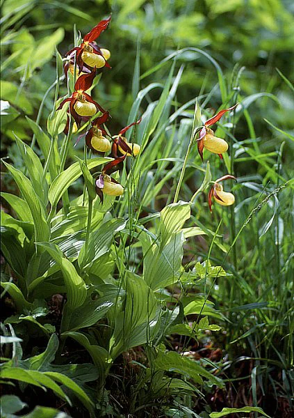
A close-up view of several Yellow Lady's Slipper orchids, Cypripedium calceolus, with bright yellow, pouch-like flowers and dark reddish-brown petals, growing in a lush green forest understory.
Yellow Lady's Slipper orchids, a rare and protected species found within the ravine forests of the Wutach region.

Blumberger Pforte und Mittlere Wutach history and protected-area timeline

The formal history of Blumberger Pforte und Mittlere Wutach as a European protected site dates to 2004, when the Regierungspräsidium Freiburg proposed the area to the European Commission as a candidate site under the EU Habitats Directive (Richtlinie 92/43/EWG). After a long application and consultation phase, the area was formally designated by ordinance of the Regierungspräsidium on 25 October 2018 and entered into force on 11 January 2019, receiving the official site code DE-8216-341.

Before its EU designation the area was already recognized for its exceptional natural value, partly through its position within the Naturpark Südschwarzwald and through a network of pre-existing nature reserves that had protected key features for decades. Smaller reserves such as Wutachflühen, Auäcker, Lindenberg-Spießenberg, Billibuck, and Braunhalden-Schlattboden predate the FFH site and now lie wholly or partially within it, with their protection regimes complementing the wider Habitats Directive framework.

The Habitats Directive designation consolidated these earlier efforts into a single coherent management plan and brought EU-level species and habitat obligations to the area. The site is now part of the Natura 2000 network and contributes to Germany's reporting on conservation status for habitats such as limestone beech forests, juniper heaths, and tufa-forming springs.

Blumberger Pforte und Mittlere Wutach landscape and geographic character

The landscape of Blumberger Pforte und Mittlere Wutach is dominated by the dramatic middle section of the Wutach gorge, downstream of the Wutachknie where the river changes its general course and cuts sharply west toward the Rhine. Steep cliff walls of limestone rise above the river, while brightly colored talus and scree slopes carry thin soil and pioneer plant communities. Water seeping through calcareous rock has produced numerous small tufa springs scattered through the valley.

Above the rim of the gorge, the terrain opens into plateaus that belong partly to the Swabian Alb foothills and partly to the High Black Forest. These uplands are much gentler in relief but ecologically rich, carrying a mosaic of dry grassland, juniper heath, low-intensity hay meadows, and beech forest. The transition from cliff-bound valley forest to open plateau grassland within just a few hundred meters gives the protected area a highly compressed altitudinal and ecological gradient.

Caves are an important geological signature of the site as well. Eighteen caves are recorded within the protected boundary, primarily in the limestone strata that underlie the Wutach valley. Combined with karst springs, travertine (tufa) formations, and rocky cliff ledges, these caves give the area an unusually strong karst landscape component within the broader southern Black Forest region.
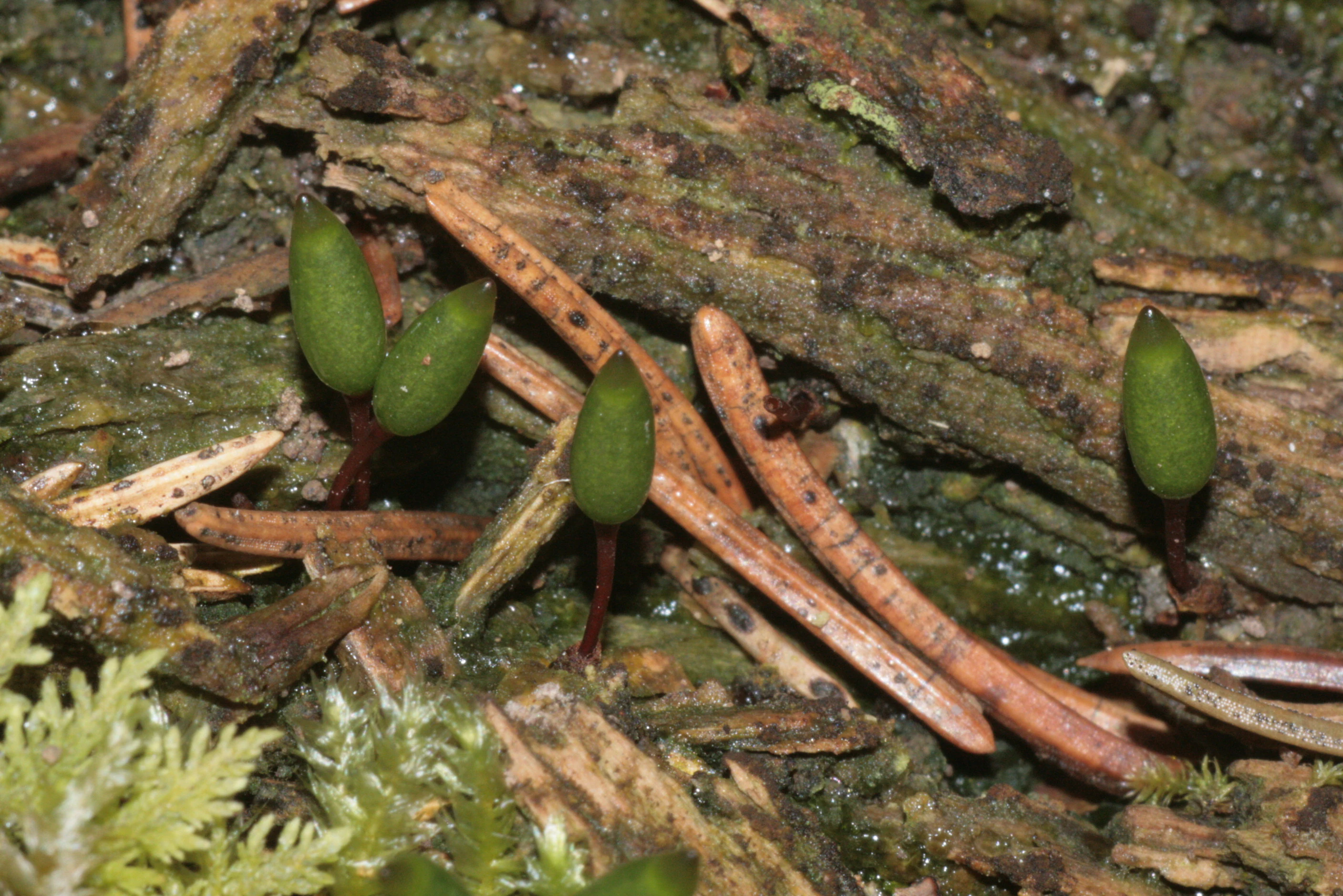
A close up view of several green shield moss sporophytes growing out of forest floor debris and pine needles.
Green shield moss, Buxbaumia viridis, growing on decaying organic matter.

Blumberger Pforte und Mittlere Wutach ecosystems, habitats, and plant life

Ecologically, the site is shaped by the geological boundary between the calcareous Swabian Alb and the more siliceous Black Forest, a transition that produces an unusually concentrated mix of habitat types. The full habitat list under Annex I of the Habitats Directive includes no fewer than eighteen habitat types across forest, grassland, freshwater, rocky, and cave categories.

The forests are particularly varied. Wooded ravine and slope forests of ash and sycamore (Tilio-Acerion) line the gorge walls; orchid-rich calcareous beech forests (Cephalanthero-Fagion) occur where soils are thin and base-rich; melica-beech forests (Asperulo-Fagetum) occupy deeper plateau soils; and alder-ash-willow floodplain forests fringe the river. Smaller communities include relict steppe pine forest, a highly unusual type in southern Germany.

Open habitats mirror the diversity of the forests. Semi-dry calcareous grasslands, montane mat-grass grasslands on siliceous soils, small juniper heaths, molinia meadows on calcareous ground, mountain hay meadows, and nutrient-poor flatland hay meadows all occur across the plateaus and clearings. Calcareous scree slopes, low cliffs, tufa springs, and calcareous fens supplement this pattern and add microhabitats for many specialized species.
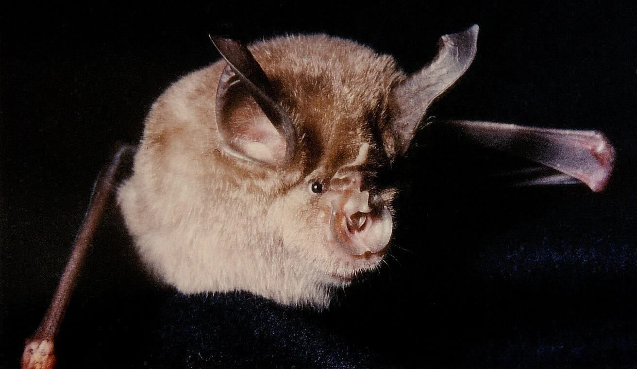
A close up view of a greater horseshoe bat with light brown fur, prominent ears, and a distinct horseshoe shaped nose structure, set against a dark background.
A greater horseshoe bat, a notable species found within the Blumberger Pforte und Mittlere Wutach nature reserve.

Blumberger Pforte und Mittlere Wutach wildlife and species highlights

The wildlife interest of Blumberger Pforte und Mittlere Wutach is closely tied to its habitat diversity, and the site's official species list includes representatives from mammals, bats, amphibians, fish, butterflies, mosses, and orchids. Among mammals, the area documents several bat species of conservation concern, including the greater horseshoe bat, the barbastelle, Bechstein's bat, and the greater mouse-eared bat, all of which depend on the network of caves, old trees, and structurally rich forests present here.

The yellowish-bellied toad (Bombina variegata) is one of the most characteristic amphibians of the area, breeding in shallow, sun-warmed pools along the valley and benefiting from the combination of woodland cover and open rocky seepage zones. Streams host the brook lamprey (Lampetra planeri) and the bullhead (Cottus gobio), both classic indicators of clean, well-oxygenated small watercourses in European uplands.

Two mosses of community interest, Buxbaumia viridis and Dicranum viride, reflect the value of old, undisturbed woodlands and humid rock faces. The Jersey tiger moth (Callimorpha quadripunctaria) marks the invertebrate interest, while the lady's slipper orchid (Cypripedium calceolus) is a flagship species for the calcareous plateau grasslands and woodland edges, signaling the rarity and richness of the flora within the protected area.
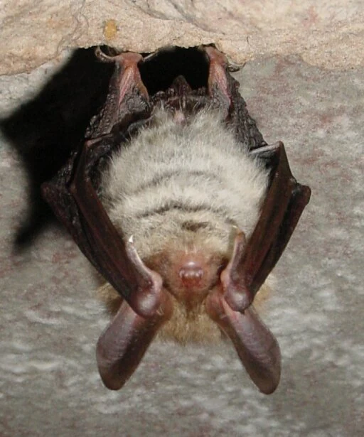
A close-up of a furry bat hanging upside down by its claws from a rough, rocky cave ceiling.
A Bechstein's bat roosting in a cave.

Blumberger Pforte und Mittlere Wutach conservation status and protection priorities

Conservation significance at Blumberger Pforte und Mittlere Wutach comes from the exceptional concentration of threatened habitat types and species within a comparatively small area, mapped against the formal benchmarks of the EU Habitats Directive. The site covers habitat types such as 9180* Tilio-Acerion gorge forests, 9150 orchid calcareous beech forest, 7220* tufa springs, 7230 calcareous fens, 8310 caves, and 6210 semi-dry calcareous grasslands, many of which are considered priority habitats in Europe.

The protected area sits inside the broader Natura 2000 network and overlaps with the Wutach und Baaralb bird protection area, allowing conservation management to operate at both the landscape and the European network level. Several smaller national nature reserves within the boundaries add an additional layer of stricter national protection to particular cliffs, dry grasslands, or cave systems.

Management priorities include maintaining open dry habitats through traditional low-intensity grazing and mowing, protecting old-growth forest features in the gorge, safeguarding cave systems from disturbance for bat populations, and ensuring that water quality in the Wutach and its tributaries continues to support sensitive fish and invertebrate species. Because the area is also embedded in the Naturpark Südschwarzwald, conservation is reconciled with recreation, education, and regional tourism through coordinated landscape-level planning.

Blumberger Pforte und Mittlere Wutach cultural meaning and human context

The wider landscape of the Wutach gorge has long shaped local communities, with small-scale farming, hay production, and forestry traditions leaving a lasting imprint on the open plateaus and valley clearings. Much of the present-day mosaic of dry grasslands, juniper heaths, and hay meadows is a direct continuation of these historical low-intensity land uses rather than a rewilded landscape.

Within the Naturpark Südschwarzwald, the site lies in a region where the Black Forest's cultural landscape; with its small villages, valley farms, and forest-based livelihoods; meets the karstic landscape of the Swabian Alb. Long-distance hiking routes and traditional uses of the Wutach valley for timber, milling, and small-scale hydropower have produced a tightly interwoven natural and cultural heritage. The protected area represents both a conservation achievement and a recognition of how tightly European biodiversity is bound to traditional land use in this part of Germany.

Top sights and standout views in Blumberger Pforte und Mittlere Wutach

Most distinctively, the site brings together the iconic middle Wutach gorge, with its ash-sycamore forests, cliff faces, caves, and tufa springs, and an unusual upper-plateau landscape of dry limestone grassland, juniper heaths, and orchid-bearing beech forest.

Eighteen caves, multiple travertine springs, classic Swabian Alb juniper heaths, and a steppe pine forest relict community give the protected area a concentration of conservation highlights that is uncommon at this scale within Germany.

Best time to visit Blumberger Pforte und Mittlere Wutach

Late spring into early summer is especially rewarding in the Wutach valley and on the plateaus, when the beech forests are fully leafed, cave entrances and cliff ledges warm up for bat and reptile activity, and many of the calcareous grasslands come into flower. Early autumn offers warmer, more stable weather for hiking the gorge and observing the structural contrast between gorge forest and plateau grassland.

Because much of the protected area includes the Wutach gorge, cool and shaded conditions can persist into midsummer in the valley, while the open upland grasslands can be very exposed in winter. Visitors planning long hikes should expect significant elevation change between the Wutach valley and the plateau above.


Monthly climate preview

Long-term monthly temperature and precipitation patterns sampled at representative elevation

Climate Normals and Average Temperatures for Blumberger Pforte und Mittlere Wutach

Representative coordinates record measured multi-year temperature ranges alongside monthly precipitation rates for Blumberger Pforte und Mittlere Wutach. Analyzing the full twelve-month climate profile reveals the complete seasonal rhythm and long-term environmental averages.
Annual mean8 °C
-2 °C17 °C
Jan-2°
Feb-1°
Mar
Apr
May12°
Jun15°
Jul17°
Aug17°
Sep13°
Oct
Nov
Dec-1°
Warmest month
July

17.2 °C

Coolest month
January

-1.7 °C

Wettest month
June

3.7 mm/day

Driest month
February

1.9 mm/day

Park location guide

Geography guide, regional context, and park location map for Blumberger Pforte und Mittlere Wutach

Blumberger Pforte und Mittlere Wutach park geography, regions, and map view in Germany

Understand where Blumberger Pforte und Mittlere Wutach sits in Germany through a broader geographic reading of the surrounding landscape, nearby location context, and its mapped position within the national park landscape.

How Blumberger Pforte und Mittlere Wutach fits into Germany

Germany is a federal republic in Western and Central Europe with a population of over 83 million across sixteen constituent states. It is Europe's largest economy by nominal GDP and a major global exporter and importer. The capital is Berlin, and the country borders Denmark, Poland, Czech Republic, Austria, Switzerland, France, Luxembourg, Belgium, and the Netherlands.

Wider geography shaping Blumberger Pforte und Mittlere Wutach in Germany

Germany is located in Western and Central Europe, spanning 357,022 km². It borders Denmark to the north, Poland and the Czech Republic to the east, Austria and Switzerland to the south, and France, Luxembourg, Belgium, and the Netherlands to the west. The country has coastlines on the Baltic Sea and North Sea to the north, with the Alps located in the southern region.

Map view of Blumberger Pforte und Mittlere Wutach

Use this park location map to pinpoint Blumberger Pforte und Mittlere Wutach in Germany, understand its exact geographic position, and read its mapped placement within the surrounding landscape more clearly.

Pigeon | © OpenStreetMap contributors

Location context for Blumberger Pforte und Mittlere Wutach

Baden-Württemberg
Recorded earthquake history

Explore the Historical Earthquake Records for Blumberger Pforte und Mittlere Wutach

Review the documented history of seismic events identified in the vicinity of Blumberger Pforte und Mittlere Wutach. MoriAtlas provides a structured, filterable catalogue of regional earthquake data to assist with landscape-level geographic analysis of the area.

Blumberger Pforte Earthquake History

Catalogued events

66 events

Strongest magnitude

Magnitude 4.8

Most recent event

Jun 27, 2024

This history includes earthquakes recorded inside the park or within 50 km of its borders

Visual exploration of limestone gorges, steep cliffs, and protected habitats

Blumberger Pforte und Mittlere Wutach Photos and Landscape Scenery

Visual documentation of Blumberger Pforte und Mittlere Wutach reveals the dramatic topography of the incised river gorge, towering limestone cliffs, and surrounding plateau habitats. Field photography provides a clear record of the complex terrain, rare plant communities, and distinct conservation zones within the protected landscape.

A close-up view of several Yellow Lady's Slipper orchids, Cypripedium calceolus, with bright yellow, pouch-like flowers and dark reddish-brown petals, growing in a lush green forest understory.

A close up view of a dark brown Western Barbastelle bat with ears joined at the base, resting against a textured gray rock.

A close up view of several green shield moss sporophytes growing out of forest floor debris and pine needles.

A close up view of a greater horseshoe bat with light brown fur, prominent ears, and a distinct horseshoe shaped nose structure, set against a dark background.

A close-up of a furry bat hanging upside down by its claws from a rough, rocky cave ceiling.

Park atlas

Compare regional park geography and connected natural reserves across the southern Black Forest

Parks Near Blumberger Pforte und Mittlere Wutach and Surrounding Protected Areas

Browsing other protected areas near Blumberger Pforte und Mittlere Wutach reveals broader ecological patterns across the surrounding transition zones. Comparing adjacent river gorges and plateau reserves provides deeper context for regional park geography and conservation landscapes.
Nature reserveAargau
13 km away#1 closest

Southwest

Klingnauer Stausee Nature Reserve: Aargau Wetland and Aare River Floodplain Landscapes

Protected riparian habitat in the northern Swiss Jura

Klingnauer Stausee stands as a primary example of integrated hydropower and conservation. This artificial reservoir and its surrounding wetlands, located in the Aargau region, encompass a variety of protected habitats ranging from open still waters to alluvial forests. These landscapes provide essential refuge for migratory waterbirds and preserve unique remnants of the historical Aare River floodplain structure.

Area
1.16 km²
Established
1935
Relief
Lowland
Climate
Temperate
Watercolor painting of a river landscape with lush green riverbanks, patches of grass in the foreground, and gentle rolling hills in the background.
Protected landscapeAargau
About 14 km away#2 closest

Southwest

Aarelandschaft bei Klingnau: A Protected Riverine Landscape in Northern Switzerland

Wetland geography, alluvial forests, and floodplain corridors

The Aarelandschaft bei Klingnau preserves a unique riverine mosaic where the Aare River meets the Rhine in northern Aargau. This protected landscape encompasses the Klingnauer Stausee reservoir, rich alluvial forests, and remnant oxbows. It serves as a vital migratory node for avian populations and provides a structured look at the interplay between human-engineered power infrastructure and protected natural river channels.

Area
3.6 km²
Established
1996
IUCN
V
Relief
Lowland
Protected landscapeBaden-Württemberg
About 15 km away#3 closest

Northeast

Hegau Protected Landscape in Baden-Württemberg: Atlas and Geographic Regional Map

Plateau landscape and agricultural heritage in Tuttlingen

The Hegau protected landscape in the Landkreis Tuttlingen preserves a characteristic segment of the Hegaualb plateau. Defined by undulating farmland, meadows, and the isolated Franzengrund woodland, this reserve offers a clear look at the rural geography and cultural landscape patterns typical of this part of southwestern Germany.

Area
2.723 km²
Established
1952
IUCN
V
Relief
Upland
Watercolor painting of a pastoral landscape featuring soft, rolling green hills and a small group of evergreen trees, with light pastel mountains in the background.
Protected landscapeBaden-Württemberg
About 16 km away#4 closest

West

St. Blasien Protected Landscape: Geographic Profile and Glacial Mapping

Southern Black Forest protected area in Baden-Württemberg.

The St. Blasien Protected Landscape represents a significant conservation zone in the southern Black Forest. Defined by its strong glacial influence, the area showcases a complex terrain of trough valleys, moraine ridges, and rocky crests alongside centuries-old alpine pastures. Its role in the regional conservation network makes it a key site for understanding the intersection of Pleistocene geography and traditional land management in Germany.

Area
35.754 km²
Established
2002
IUCN
V
Protected landscapeBaden-Württemberg
About 17 km away#5 closest

Northwest

Titisee-Neustadt Protected Landscape: Mapping the Black Forest Terrain and Boundaries

Regional geography and protected area coverage in Baden-Württemberg

Gain insight into the Titisee-Neustadt protected landscape, a representative high Black Forest area defined by its mix of forested ridges and river-fed valley basins. This detailed geographic overview highlights the physical features, water systems, and structural conservation status that define this landmark site within the southern German state of Baden-Württemberg.

Area
83.17 km²
Established
2003
IUCN
V
Relief
Highland
Protected landscapeSchwarzwald-Baar-Kreis
About 24 km away#6 closest

North

Groppertal Protected Landscape in Schwarzwald-Baar-Kreis: Regional Geography and Atlas

Mapped riparian meadows and Black Forest woodland boundaries

Groppertal is a protected landscape situated within the Schwarzwald-Baar-Kreis, defined by the Brigach river valley. The area exhibits a unique contrast between maintained lowland wet meadows and expansive forest slopes. This geography provides an essential protected corridor connecting the riparian ecosystem of the river floodplain to the wider highland terrain of the South-eastern Black Forest, illustrating a complex rural-natural mosaic.

Area
5.397 km²
Established
1957
IUCN
V
Relief
Upland
Protected landscapeBaden-Württemberg
About 25 km away#7 closest

North

Hänge mit Wald und Hecken im Neckartal und Mückenbachtal Protected Landscape and Valley Map

Geographic study of the upper Neckar valley and Mückenbachtal terrain

Investigate the layered landscape of Hänge mit Wald und Hecken im Neckartal und Mückenbachtal, where open grassland plains meet steep, forest-covered valley walls. This protected area provides a clear look at regional river-valley morphology and the integration of natural habitats near the A 81 corridor within the Baden-Württemberg state boundaries.

Area
0.223 km²
Established
1953
IUCN
V
Relief
Upland
Watercolor painting depicting a gentle hill with forest cover and a winding river in the foreground, using soft pastel tones.
Protected landscapeLandkreis Tuttlingen
About 25 km away#8 closest

Northeast

Honberg Protected Landscape: Geological Atlas and Mapped Terrain in Landkreis Tuttlingen

A preserved Danube Umlaufberg and historical cultural landmark.

The Honberg represents a rare example of a protected landscape fully integrated within an urban setting in southwestern Germany. Defined by its origin as a Danube river meander, the ridge showcases layered limestone formations, diverse meadow habitats, and ancient fortification sites that remain shielded from regional development. This site is essential for understanding the local topography of the Swabian Alb and the historical land-use patterns within the Danube valley.

Area
0.598 km²
Established
1986
IUCN
V

Common questions about visiting, size, designation, and location context for Blumberger Pforte und Mittlere Wutach

Blumberger Pforte und Mittlere Wutach FAQs for park facts, access, geography, and protected area context

Find quick answers about Blumberger Pforte und Mittlere Wutach, including protected-area facts, park geography, trail and visitor context, and how the park fits into its surrounding country and regional landscape.
MoriAtlas Explorer

Continue Your Protected Areas Search Across the Global Atlas

Deepen your exploration by continuing the structured search for national parks and protected areas worldwide. Utilize the comprehensive filtering capabilities to compare different conservation landscapes and refine your understanding of global park geography. Discover more about the distribution and characteristics of protected natural areas.

Global natural geography