

Mori Atlas logo
Marine protected areaBoags Commonwealth Marine Reserve

A vital marine protected area in Tasmania, representing soft-sediment benthic ecosystems and seabird foraging corridors.

Boags Commonwealth Marine Reserve: Protected Marine Geography and Bass Strait Seafloor Habitats

Boags Commonwealth Marine Reserve encompasses 537 square kilometers of the energetic Bass Strait between the Australian mainland and Tasmania. This marine protected area serves as a critical benthic habitat, where soft-sediment seafloors support diverse invertebrate communities. Beyond the seabed, the reserve functions as a primary foraging ground for seabird populations breeding within the nearby Hunter Island Group.

marine protected areaCommonwealth marine reserveBass Straitsoft sediment seafloorbenthic habitatseabird foraging area

Boags Commonwealth Marine Reserve

Marine protected area

Park overview

Structured park overview, official facts, and landscape profile for Boags Commonwealth Marine Reserve

Boags Commonwealth Marine Reserve park facts, protected area profile, and essential visitor context

Review the core facts for Boags Commonwealth Marine Reserve, including designation, size, terrain, visitor scale, habitats, and operating context in one park-focused overview.

About Boags Commonwealth Marine Reserve

Boags Commonwealth Marine Reserve represents a focused but ecologically meaningful slice of Australia's southern marine environment. Despite being the smallest unit within the South-east Commonwealth Marine Reserve Network, it embodies the network's broader aim of conserving examples of the diverse marine habitats found in Commonwealth waters beyond the state boundary of Tasmania.

The waters of Bass Strait are a transitional zone where the cooler southern oceans meet the more temperate waters to the north, producing high biological productivity and varied seafloor conditions. Boags captures part of this transition, protecting an area where soft sediments dominate and where benthic fauna thrive. The reserve therefore serves as a living reference site for understanding the structure and function of muddy and sandy seabed ecosystems in this part of Australia.

A defining aspect of Boags is its geographic relationship with the nearby Hunter Island Group. The seabirds that nest in dense colonies on these remote islands must travel significant distances to feed, and Boags forms part of their foraging range. This proximity creates a functional link between a terrestrial seabird habitat and a marine reserve, where the health of one directly influences the other.

Management of the reserve reflects the Commonwealth's approach to balancing conservation with sustainable use. By zoning the entire area as Multiple Use under IUCN Category VI, the reserve acknowledges that supporting compatible human activity, including regulated fishing, can coexist alongside the protection of marine biodiversity. This framework positions Boags not as an untouched wilderness reserve but as a working example of integrated marine spatial planning in Australian waters.

Quick facts and research context for Boags Commonwealth Marine Reserve

Boags Commonwealth Marine Reserve sits in Bass Strait, north-west of Tasmania, with the nearest mainland town being Stanley. The reserve covers 537 square kilometers of Commonwealth waters and was proclaimed on 31 August 2007 under the South-east Commonwealth Marine Reserve Network.

Its entire area is classified as IUCN Category VI and is zoned as Multiple Use, allowing recreational fishing throughout and permitting commercial fishing and mining only with approval. Governance is provided by Parks Australia on behalf of the Commonwealth of Australia.

Protection and recognition

Marine conservation framework, management scope, and recognition data

Boags Commonwealth Marine Reserve Protection Status and Designation Records

Marine protection status and management scope for Boags Commonwealth Marine Reserve appear alongside structured designation records. Documented conservation parameters establish the operational framework for this marine protected area.

Protection details

Protection scope
Marine
Transboundary protection
No
Park context

Deeper park guide and search-rich context for Boags Commonwealth Marine Reserve

Boags Commonwealth Marine Reserve history, landscape, wildlife, and travel context

Explore Boags Commonwealth Marine Reserve through its history, landscape character, ecosystems, wildlife, conservation priorities, cultural context, and seasonal travel timing in a structured park guide built for atlas discovery and search intent.

Why Boags Commonwealth Marine Reserve stands out

Boags Commonwealth Marine Reserve is best known as a representative sample of the soft-sediment seafloor habitats of Bass Strait. The reserve's muddy and sandy seabeds are home to diverse invertebrate communities that underpin the broader marine ecosystem of the region. Beyond its benthic character, the reserve is also valued for its role as a marine feeding area for the seabird colonies of the nearby Hunter Island Group. Birds breeding on islands such as Three Hummock Island range across Boags in search of food, linking the reserve's marine productivity to one of Tasmania's most important seabird breeding regions.

Boags Commonwealth Marine Reserve history and protected-area timeline

Boags Commonwealth Marine Reserve was officially established on 31 August 2007 as part of the development of Australia's Commonwealth marine reserve system. Its creation coincided with the broader designation of the South-east Commonwealth Marine Reserve Network, a planning initiative aimed at representing the full range of marine environments found in Commonwealth waters off south-eastern Australia.

Within that network, Boags was recognized as a necessary inclusion because it captured a specific environmental character, the soft-sediment benthic habitats of Bass Strait, that other reserves did not represent as well. Its establishment therefore reflects a scientific approach to marine conservation, where individual reserves are chosen to contribute unique ecological value to a connected system.

Since its proclamation, Boags has been managed under the Commonwealth marine reserve framework, with Parks Australia serving as the governing body. Its zoning as a Multiple Use area has shaped how activities such as fishing and potential resource extraction are regulated, marking an evolution in how Australia balances ecological preservation with continued use of marine resources in selected areas.

Boags Commonwealth Marine Reserve landscape and geographic character

Although Boags is a marine rather than a terrestrial reserve, its physical character is defined entirely by the underwater seascape of Bass Strait. The reserve's seabed consists predominantly of soft sediments, including muds and fine sands, that have accumulated in this energetic stretch of water between Tasmania and the Australian mainland.

These soft-bottom environments are shaped by tidal currents, wave action, and the discharge of rivers flowing into Bass Strait from both sides of the channel. The result is a dynamic seafloor where sediment movement influences the community of organisms that can establish themselves in any given location.

The reserve's surface waters are part of one of Australia's most recognizable marine corridors, visible from the cliffs and headlands of north-west Tasmania. The nearby coast around Stanley features some of the most dramatic shoreline scenery in Tasmania, providing a striking terrestrial backdrop to a marine environment that is otherwise defined by what lies beneath the waves.

Boags Commonwealth Marine Reserve ecosystems, habitats, and plant life

The ecological identity of Boags Commonwealth Marine Reserve is rooted in its benthic, or bottom-dwelling, communities. The soft sediments across the reserve support dense populations of invertebrates that live within or on the seabed, including crustaceans, polychaete worms, and a variety of molluscs.

These organisms play a critical ecological role, recycling nutrients and serving as a primary food source for higher levels of the marine food web. The reserve therefore protects not just individual species but an entire functional community that sustains larger predators, including fish, marine mammals, and seabirds that feed over the reserve.

Bass Strait itself is recognized as a highly productive marine ecosystem, and Boags contributes to the conservation of its characteristic soft-sediment habitats. By safeguarding these habitats from more intensive forms of disturbance, the reserve helps maintain the ecological processes that sustain both resident species and seasonal visitors.

Boags Commonwealth Marine Reserve wildlife and species highlights

The wildlife focus of Boags Commonwealth Marine Reserve centers on its benthic fauna. Crustaceans, polychaete worms, and molluscs dominate the soft-sediment communities, forming the biological foundation of the reserve.

Above the waves, the reserve gains additional wildlife significance as a foraging area for seabirds. The Hunter Island Group, including Three Hummock Island, supports breeding colonies that rely on the productive waters of Bass Strait, including those within Boags, for feeding. The reserve is therefore an important component of the marine territory used by these island-nesting birds during their most energetically demanding life stages.

Boags Commonwealth Marine Reserve conservation status and protection priorities

Boags Commonwealth Marine Reserve contributes to conservation by protecting a representative sample of Bass Strait's soft-sediment marine habitats within Australia's national system of Commonwealth marine reserves. Its inclusion in the South-east Commonwealth Marine Reserve Network reflects a deliberate effort to ensure that the network captures the full ecological diversity of the region's marine environments.

The reserve's Multiple Use zoning under IUCN Category VI reflects a conservation approach that allows regulated human activities to continue alongside habitat protection. This framework aims to maintain ecological functions and biodiversity while permitting compatible resource use, demonstrating how conservation objectives can be achieved alongside sustainable marine activity.

Because Boags supports foraging seabirds from nearby colonies, its conservation value extends beyond its own boundaries. Protecting the marine area indirectly supports the long-term viability of seabird populations breeding on islands that depend on the productivity of surrounding waters.

Boags Commonwealth Marine Reserve cultural meaning and human context

The waters of Bass Strait, including the area now designated as Boags Commonwealth Marine Reserve, have long been part of the working maritime landscape of north-west Tasmania. Stanley and other nearby coastal communities have historical connections to fishing, shipping, and marine industries that continue to shape local identity.

The introduction of a Commonwealth marine reserve over a portion of these waters represents a shift toward recognizing the ecological value of the region alongside its longstanding economic uses. This balance between traditional marine livelihoods and modern conservation frameworks forms an important element of the reserve's cultural context.

Top sights and standout views in Boags Commonwealth Marine Reserve

Boags Commonwealth Marine Reserve stands out as the South-east Network's smallest reserve, yet it captures a unique ecological niche within Bass Strait. Its soft-sediment seafloor communities of crustaceans, polychaete worms, and molluscs represent one of the defining habitat types of this stretch of Australian marine environment.

Equally important is the reserve's role in supporting the seabird colonies of the Hunter Island Group, with its waters functioning as part of the foraging range for some of Tasmania's most remote island-based bird populations. These twin identities, benthic habitat and seabird feeding ground, give the reserve a layered ecological character that strengthens its place within Australia's Commonwealth marine reserve system.

Best time to visit Boags Commonwealth Marine Reserve

Given its status as a marine rather than a terrestrial reserve, Boags Commonwealth Marine Reserve is best appreciated through the changing conditions of Bass Strait across the seasons. Cooler months often bring more active seabird presence around the nearby islands and more dynamic sea conditions, while calmer summer periods typically offer smoother waters for viewing the coastal scenery of north-west Tasmania from vantage points near Stanley.

Since access to the reserve itself is primarily by sea, those interested in its ecological character often time visits to coincide with favorable weather windows and increased opportunities to observe seabird activity around the Hunter Island Group. As always, conditions in Bass Strait can change rapidly, and seasonal awareness remains important for any marine-based exploration in the region.
Monthly climate preview

Long-term annual temperature and precipitation normals for Tasmania

Boags Commonwealth Marine Reserve Climate and Weather by Month

Representative coordinates record measured monthly temperature and precipitation rhythms across the marine reserve. Examining the complete twelve-month climatology profile reveals detailed seasonal variations in regional averages.
Annual mean14 °C
12 °C17 °C
Jan16°
Feb17°
Mar17°
Apr15°
May14°
Jun13°
Jul12°
Aug12°
Sep12°
Oct13°
Nov14°
Dec15°
Warmest month
February

16.9 °C

Coolest month
August

12 °C

Wettest month
July

3.9 mm/day

Driest month
February

1.7 mm/day

Park location guide

Geography guide, regional context, and park location map for Boags Commonwealth Marine Reserve

Boags Commonwealth Marine Reserve park geography, regions, and map view in Australia

Understand where Boags Commonwealth Marine Reserve sits in Australia through a broader geographic reading of the surrounding landscape, nearby location context, and its mapped position within the national park landscape.

How Boags Commonwealth Marine Reserve fits into Australia

Australia is a constitutional monarchy and federal parliamentary democracy comprising six states and ten territories. With a population of nearly 28 million, it is one of the world's most urbanised countries, with most people concentrated on the eastern seaboard. The country has a high Human Development Index and is known for its cultural diversity, ancient Aboriginal heritage, and unique wildlife.

Wider geography shaping Boags Commonwealth Marine Reserve in Australia

Australia occupies the entire Australian continent, the island of Tasmania, and numerous smaller islands. It is the world's flattest and driest inhabited continent, featuring vast deserts in the interior (the Outback), tropical rainforests along the eastern coast, and a coastline bordering the Indian and Pacific Oceans.

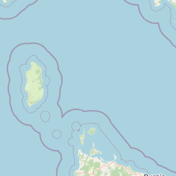
Map view of Boags Commonwealth Marine Reserve

Use this park location map to pinpoint Boags Commonwealth Marine Reserve in Australia, understand its exact geographic position, and read its mapped placement within the surrounding landscape more clearly.

Pigeon | © OpenStreetMap contributors

Location context for Boags Commonwealth Marine Reserve

Tasmania
Recorded earthquake history

Explore the Recorded Earthquake History for Boags Commonwealth Marine Reserve

Access a detailed catalogue of historical seismic events recorded near the Boags Commonwealth Marine Reserve. MoriAtlas organizes this geographic data by epicentre distance, providing a clear reference for understanding documented activity patterns within the Bass Strait marine corridor.

Boags Commonwealth Marine Reserve Earthquake History

Catalogued events

1 event

Strongest magnitude

Magnitude 3.8

Most recent event

Sep 8, 2007

This history includes earthquakes recorded inside the park or within 50 km of its borders

Park atlas

Compare adjacent marine reserves, island habitats, and regional protected areas.

Explore Other Parks Near Boags Commonwealth Marine Reserve and Surrounding Waters

Browse protected areas and marine reserves situated near Boags Commonwealth Marine Reserve in Bass Strait. Regional park comparison reveals connected ecological networks and benthic seafloor habitats across Tasmania.
Marine protected areaTasmania
43 km away#1 closest

Southwest

Franklin Commonwealth Marine Reserve: Geography and Marine Protected Area Mapping

Tasmania marine environment and shelf topography

Located off the coast of north-western Tasmania, Franklin Commonwealth Marine Reserve serves as a strategic marine protected area. This record maps its 671 square kilometer expanse, highlighting the intersection of the Bass Strait and the Tasmanian continental shelf, and the significance of Black Pyramid Rock to regional seabird conservation.

Area
671 km²
Established
2007
IUCN
VI
Relief
Lowland
National parkTasmania
66 km away#2 closest

Southeast

Rocky Cape National Park: Tasmania's Coastal National Park with Ancient Aboriginal Heritage

Explore the dramatic headland, heath ecosystems, and mapped park boundaries.

Rocky Cape National Park on Tasmania's North West Coast is a nationally significant protected area recognized for its ancient Aboriginal archaeological heritage, representing at least 8,000 years of continuous occupation. The park's landscape unfolds across a dramatic coastal headland, featuring rugged rocky shores, expansive heathlands, and coastal woodlands that define this wild section of Tasmania. Its protected status underscores its importance for both cultural discovery and the preservation of unique Australian coastal ecosystems. Understanding Rocky Cape National Park offers direct insight into the region's geography and the enduring legacy of its first peoples.

Area
30.64 km²
Established
1967
IUCN
II
Relief
Lowland
Marine protected areaTasmania
101 km away#3 closest

Southwest

Zeehan Commonwealth Marine Reserve: Geographic Map and Protected Marine Landscape Overview

Deep-sea habitats and shelf bathymetry off the Tasmanian coast

Spanning from fifty meters to over three thousand meters deep, the Zeehan Commonwealth Marine Reserve represents a massive, bathymetrically diverse protected area in the southern Indian Ocean. This geographic overview highlights the reserve's role in conserving limestone seabed features and deep-sea corridors west of Tasmania, offering a clear perspective on its location and scale within the broader regional marine network.

Area
19,897 km²
Established
2007
IUCN
VI
Relief
Lowland
National parkTasmania
103 km away#4 closest

South

Savage River National Park: Discover Tasmania's Protected Landscape Geography

Explore mapped boundaries and regional park context.

Savage River National Park represents a distinct protected area within Tasmania, Australia, offering valuable insights into the island's natural geography and conservation landscape. As a designated national park, its mapped territory contributes to the understanding of regional protected areas and their distribution across Tasmania. This entity serves as a crucial point for atlas-based exploration, allowing users to grasp its geographic identity and its place within a broader map of Australian natural territories.

Area
179.8 km²
Established
1999
IUCN
II
Climate
Temperate
Marine protected areaVictoria
113 km away#5 closest

Northwest

Apollo Marine Park: A Submarine Atlas of the Bass Strait Basin and Otway Depression

Examining underwater topography and maritime heritage off Victoria

Apollo Marine Park represents a critical offshore protected area, spanning over 1,180 square kilometres of seabed. Its primary feature, the Otway Depression, offers a window into ice age geology through drowned river valleys and fossil drainage channels that once defined the Bassian Plain. The reserve functions as an underwater archive of southeastern Australian environmental history, integrating deep-time geomorphology with significant twentieth-century maritime shipwreck remnants.

Area
1,184 km²
Established
2007
IUCN
VI
Relief
Lowland
Marine protected areaVictoria
135 km away#6 closest

Northeast

Beagle Commonwealth Marine Reserve: Mapping Bass Strait and Victorian Marine Protected Areas

Submerged continental shelf and Bassian Plain geography

The Beagle Commonwealth Marine Reserve protects nearly 3,000 square kilometres of the Bass Strait seabed. This site offers deep insight into the region's submerged landscape history, featuring geological remnants of the ancient Bassian Plain and a series of rugged island archipelagos that frame this temperate marine environment.

Area
2,928 km²
Established
2007
IUCN
VI
Relief
Lowland
National parkAustralia
147 km away#7 closest

Northeast

Wilsons Promontory National Park: Southernmost Australian National Park with Granite Landscapes and Rainforests

Mapped geography of a dramatic coastal and wilderness park.

Wilsons Promontory National Park, situated at Australia's southern mainland extremity, represents a significant protected landscape. The park's geography is defined by ancient granite formations, creating dramatic peaks and headlands that meet the Bass Strait. Within its boundaries, diverse ecosystems flourish, including rare temperate rainforests and heathy woodlands. This page provides detailed geographic context and atlas-style discovery for this iconic protected area.

Area
505 km²
Established
1898
IUCN
II
Relief
Mixed relief
Marine protected areaAustralia
147 km away#8 closest

Northeast

Wilsons Promontory Marine National Park: Australia's Southern Marine Protected Landscape

Explore mapped boundaries and island ecosystems at the edge of Bass Strait.

Wilsons Promontory Marine National Park, a 15,500-hectare marine protected area in Victoria, Australia, offers unique atlas exploration of its coastal and island geography. The park's waters surround the Glennie and Anser island groups, showcasing a complex marine terrain where Bass Strait transitions into the Southern Ocean. It complements the adjacent terrestrial national park, creating a comprehensive protected landscape vital for marine biodiversity and regional geographic context. Discover its mapped marine environment and ecologically significant island habitats.

Area
155 km²
Established
2003
IUCN
II
Scope
Marine

Common questions about visiting, size, designation, and location context for Boags Commonwealth Marine Reserve

Boags Commonwealth Marine Reserve FAQs for park facts, access, geography, and protected area context

Find quick answers about Boags Commonwealth Marine Reserve, including protected-area facts, park geography, trail and visitor context, and how the park fits into its surrounding country and regional landscape.
MoriAtlas Explorer

Continue Your Protected Areas Search Across the Global Atlas

Deepen your exploration by continuing the structured search for national parks and protected areas worldwide. Utilize the comprehensive filtering capabilities to compare different conservation landscapes and refine your understanding of global park geography. Discover more about the distribution and characteristics of protected natural areas.

Global natural geography