

Mori Atlas logo
National parkWilsons Promontory National Park

Explore the mapped boundaries of Victoria's dramatic coastal terrain and ancient rainforests.

Wilsons Promontory National Park: A Protected Granite Landscape at Australia's Southernmost Reach

Wilsons Promontory National Park, located on mainland Australia's southernmost peninsula, offers a profound discovery of protected landscapes. This expansive national park preserves a unique geographic tapestry, from rugged granite mountains and dramatic coastal cliffs to secluded beaches and rare temperate rainforests. Its protected status ensures the preservation of diverse ecosystems and abundant wildlife, making it a key destination for understanding Australia's natural heritage through map-based exploration.

rainforestcoastal national parkgranite landscapeshiking trailsAustralian wildlifetemperate rainforest

Wilsons Promontory National Park

National park

Park overview

Structured park overview, official facts, and landscape profile for Wilsons Promontory National Park

Wilsons Promontory National Park park facts, protected area profile, and essential visitor context
Review the core facts for Wilsons Promontory National Park, including designation, size, terrain, visitor scale, habitats, and operating context in one park-focused overview.

About Wilsons Promontory National Park

Wilsons Promontory National Park occupies a distinctive position in Australia's protected area network as the southernmost national park on the Australian mainland. The park encompasses the southern portion of Wilsons Promontory, a peninsula that protrudes into the Bass Strait between the mainland and Tasmania, creating a unique biogeographic stepping stone between the continental landmass and the island state. The park's geography is defined by its dramatic topography, with Mount Oberon and surrounding granite peaks forming a mountainous spine that rises sharply from the surrounding terrain. The landscape presents remarkable variety across relatively compact distances, transitioning from the wet, fern-dense gullies of the southern rainforests to the drier, heathy woodlands of the Yanakie Isthmus in the north. The coastline exhibits classic temperate coastal geomorphology, with long sandy beaches interrupted by granite headlands, sheltered coves, and towering cliffs. The park's islands, including several in the eastern portion of the protected area, provide important nesting habitat for seabirds and add complexity to the park's marine and terrestrial ecosystems. The Tidal River area serves as the primary visitor nexus, offering camping, visitor services, and access to numerous walking tracks, while more remote sections of the park require overnight hiking and provide Wilderness Zone protections for those seeking more isolated experiences.

Quick facts and research context for Wilsons Promontory National Park

Wilsons Promontory National Park covers approximately 50,500 hectares along the southern Victorian coast, making it the southernmost national park on mainland Australia. The park was first reserved as a national park in 1898 following decades of advocacy by naturalists, with permanent protection established in 1908. The peninsula contains South Point, the southernmost tip of the Australian mainland, and is flanked by the Wilsons Promontory Lighthouse, which has operated continuously since 1859 and stands as the southernmost lighthouse on mainland Australia. The park features diverse terrain including warm temperate rainforests in the southern portions, granitic mountains and coastal heaths in the north, and over 130 kilometers of dramatic coastline with sandy beaches, coves, and rocky headlands.

Park context

Deeper park guide and search-rich context for Wilsons Promontory National Park

Wilsons Promontory National Park history, landscape, wildlife, and travel context
Explore Wilsons Promontory National Park through its history, landscape character, ecosystems, wildlife, conservation priorities, cultural context, and seasonal travel timing in a structured park guide built for atlas discovery and search intent.

Why Wilsons Promontory National Park stands out

Wilsons Promontory is renowned for its exceptional combination of ecosystems, where temperate rainforests exist in close proximity to coastal heathlands and sandy beaches. The park protects one of the most significant remaining patches of warm temperate rainforest in Victoria, a rare habitat type characterized by ancient myrtle beech and soft tree ferns. Its coastline features spectacular granite formations, secluded coves, and the iconic quartzite peaks known as the Lianhabub (or The Promontory Peaks) that rise dramatically from the sea. The park is also famous for its abundant wildlife that has become remarkably habituated to visitor presence in the camping areas around Tidal River, offering close encounters with kangaroos, wombats, and numerous bird species. The multi-day hiking trails, including the famous circuit walks through the southern wilderness, rank among the most spectacular in Victoria.

Wilsons Promontory National Park history and protected-area timeline

The European discovery of Wilsons Promontory dates to 1798 when George Bass and Matthew Flinders became the first recorded Europeans to sight the peninsula during their coastal exploration. The subsequent decades saw extensive sealing activity at Sealer's Cove, where seal populations were hunted so intensively that the species was eventually eliminated from the area. The late nineteenth century marked a turning point for the region's conservation, as members of the Field Naturalists Club of Victoria and the Royal Society of Victoria, including prominent naturalist Arthur Henry Shakespeare Lucas, advocated persistently for government protection of the promontory's natural values. These efforts resulted in the Victoria State Government temporarily reserving the area as National Park in July 1898, with permanent protection achieved in 1908, making Wilsons Promontory one of the earliest national parks in Australia. The original settlement within the park was established at the Darby River site, where a chalet provided early accommodation. The Field Naturalists Club has maintained an active watching brief over the promontory for more than 120 years. During World War II, the park served as a commando training area, and a memorial at Tidal River honors those who lost their lives during military training operations. The park has experienced significant fire events, including a major bushfire in April 2005 that burned a large section of the park after a controlled burn escaped containment lines due to warmer and windier conditions than forecast, forcing the evacuation of approximately 600 people. The Black Saturday fires of February 2009 caused additional extensive damage, with lightning strikes igniting fires that destroyed up to half of the national park.

Wilsons Promontory National Park landscape and geographic character

Wilsons Promontory National Park showcases a dramatic and varied landscape shaped by geological forces spanning millions of years. The dominant geological feature is the massive granite batholith that forms the core of the peninsula, creating the rugged mountainous terrain characterized by tors, domes, and dramatic rock formations. The southern portion of the park features the most spectacular topographic relief, where the quartzite peaks of the Lianhabub rise steeply from surrounding terrain, their jagged silhouettes creating one of the most recognizable coastal skylines in Victoria. The coastline presents remarkable diversity, from the broad sandy beach of Norman Bay at Tidal River to the secluded coves and pocket beaches tucked between granite headlands along the eastern and western shores. The park contains extensive areas of warm temperate rainforest in the southern gullies, where deep shade and high moisture support lush understories of ferns, mosses, and epiphytic plants. In contrast, the northern portions around the Yanakie Isthmus feature extensive heathy woodlands on sandy soils, creating a distinctly different character. The inland areas include wetlands, heaths, and grassy woodlands that add further ecological and visual diversity to the park's landscape mosaic.

Wilsons Promontory National Park ecosystems, habitats, and plant life

The ecological character of Wilsons Promontory is defined by a remarkable convergence of habitat types within a relatively compact area. The park protects one of the most significant and extensive remnants of warm temperate rainforest in Victoria, a globally restricted ecosystem type that thrives in the moist, shaded gullies of the southern peninsula. These rainforests feature canopy dominants such as myrtle beech, southern sassafras, and Hazel pomaderris, with an understory rich in tree ferns, ground ferns, and epiphytic ferns. The transition zones between rainforest and surrounding woodland and heath communities create ecologically important ecotones that support diverse species assemblages. The park's position at the southernmost point of mainland Australia gives it significance as a biogeographic crossroads, with species from both northern and southern distributions meeting here. Coastal heathlands, heathy woodlands, and grassy ecosystems add further habitat complexity, while the marine environments surrounding the peninsula support distinct assemblages adapted to temperate waters. The park's long history of protection, dating to 1898, has allowed ecological processes to continue with relatively minimal modern human disturbance in remote areas.

Wilsons Promontory National Park wildlife and species highlights

Wilsons Promontory supports an impressive diversity of wildlife, with the park's varied habitats providing refuge for numerous species. The large marsupial fauna includes grey kangaroos and swamp wallabies, which are commonly encountered throughout the park, particularly in more open areas and along walking tracks. Common wombats are abundant, especially in the Tidal River camping area where they have become accustomed to human presence and often wander through campsites, and their burrows are visible on hillsides throughout the park. Echidnas, Australia's egg-laying monotreme, are frequently encountered as they forage across the forest floor, while emus roam through woodland and heath areas. The birdlife is particularly diverse, with rosellas, honeyeaters, wrens, and numerous other species contributing to the park's ornithological richness. The forest and heath environments support populations of possums that can be observed at night with a torch, and the northern sections of the park contain notable snake diversity. Marine mammals occasionally transit the offshore waters, while the surrounding marine national park protects additional aquatic biodiversity. The habituation of wildlife around the Tidal River camping area is notable, though feeding wildlife remains illegal and is enforced with penalties.

Wilsons Promontory National Park conservation status and protection priorities

Wilsons Promontory National Park represents one of Victoria's most significant protected areas, preserving critical examples of multiple ecosystem types within a single management unit. The park's long protection history, spanning more than 125 years, has allowed ecological communities to persist with relatively intact processes in many areas, particularly in the remote southern wilderness zones. The warm temperate rainforest communities represent a conservation priority given their restricted global distribution and the threats they face from climate change and altered fire regimes. The park's coastal and marine environments are protected through the adjacent Wilsons Promontory Marine National Park, creating an integrated coastal and terrestrial protected area network. The park's fire history, including significant events in 2005 and 2009, has informed adaptive management approaches and highlighted the challenges of fire management in temperate ecosystems with flammable vegetation. The ongoing management by Parks Victoria balances visitor access and enjoyment with conservation of the park's exceptional natural values, including maintenance of walking tracks, visitor facilities, and targeted conservation programs for significant species and communities.

Wilsons Promontory National Park cultural meaning and human context

Wilsons Promontory holds significance in the cultural landscape of both the indigenous communities who have connections to the region and the European settlers who recognized its natural values. While the Wikipedia source does not extensively detail indigenous cultural associations, the traditional lands of the Gunai/Kurnai people extend through the Gippsland region, and the peninsula would have been significant in the cultural landscape of Aboriginal communities. The park's European history is well documented, with exploration by Bass and Flinders in 1798 marking the beginning of recorded contact. The advocacy by naturalists in the late nineteenth century reflects a growing appreciation for wilderness protection that helped establish the conservation movement in Victoria. The use of the area as a World War II commando training ground adds a military heritage dimension to the park's cultural layering, commemorated by the memorial at Tidal River. The outdoor cinema at Tidal River, established in the late 1940s, represents a unique cultural tradition that continues among summer campers, illustrating how the park has become embedded in Victorian recreational culture.

Top sights and standout views in Wilsons Promontory National Park

The Wilsons Promontory experience centers on the spectacular combination of rainforests, mountains, and coastline that can be explored through its extensive walking track network. Mount Oberon provides the park's most accessible elevated viewpoint, with walking tracks from Telegraph Saddle leading to summit views encompassing Tidal River, Norman Bay, and the offshore islands. The multi-day wilderness walks through the southern sections of the park offer remote backcountry experiences among ancient rainforests and dramatic coastal scenery. The Tidal River camping area provides a hub for visitors, with the campground nestled behind sand dunes at Norman Bay offering proximity to beach access and the park's visitor center. The wildlife viewing opportunities, particularly the habituated wombats and kangaroos around Tidal River, provide memorable encounters for visitors. The park's lighthouse at South East Point stands as a historic landmark marking the southernmost point on the Australian mainland and represents the long maritime history of the peninsula.

Best time to visit Wilsons Promontory National Park

Wilsons Promontory can be visited throughout the year, with each season offering distinct experiences and considerations for visitors. The summer months of December through February represent the peak visitation period, when warm weather draws large numbers of campers to Tidal River, and a ballot system allocates campsites during the Christmas to late January peak. Summer offers optimal conditions for beach activities and swimming, though the campground can become very crowded during peak holiday periods. Autumn and spring provide more moderate conditions with fewer visitors, making these seasons ideal for those seeking a quieter experience while still enjoying comfortable temperatures for walking. Winter brings cooler conditions and significantly reduced visitor numbers, offering the opportunity to experience the park's moods and atmosphere with greater solitude, though some facilities may have reduced operating hours. The park's rainforests are particularly atmospheric during the cooler months when mist and moisture create evocative conditions. Fire risk varies seasonally, and visitor access may be affected during high fire danger periods, particularly during summer heatwaves.
Park location guide

Geography guide, regional context, and park location map for Wilsons Promontory National Park

Wilsons Promontory National Park park geography, regions, and map view in Australia
Understand where Wilsons Promontory National Park sits in Australia through a broader geographic reading of the surrounding landscape, nearby location context, and its mapped position within the national park landscape.

How Wilsons Promontory National Park fits into Australia

Australia is a constitutional monarchy and federal parliamentary democracy comprising six states and ten territories. With a population of nearly 28 million, it is one of the world's most urbanised countries, with most people concentrated on the eastern seaboard. The country has a high Human Development Index and is known for its cultural diversity, ancient Aboriginal heritage, and unique wildlife.

Wider geography shaping Wilsons Promontory National Park in Australia

Australia occupies the entire Australian continent, the island of Tasmania, and numerous smaller islands. It is the world's flattest and driest inhabited continent, featuring vast deserts in the interior (the Outback), tropical rainforests along the eastern coast, and a coastline bordering the Indian and Pacific Oceans.

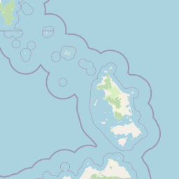
Map view of Wilsons Promontory National Park

Use this park location map to pinpoint Wilsons Promontory National Park in Australia, understand its exact geographic position, and read its mapped placement within the surrounding landscape more clearly.

Pigeon | © OpenStreetMap contributors
Park atlas

Trace the broader geographic context and diverse protected landscapes surrounding Victoria's iconic Promontory.

Explore Nearby National Parks and Protected Areas Around Wilsons Promontory
Discover other national parks and protected areas near Wilsons Promontory National Park, exploring diverse conservation landscapes across its surrounding Gippsland region. Compare key geographic features, ecosystem types, and regional protected-area spread to deepen your understanding of Victoria's natural heritage.
Marine protected area

Wilsons Promontory Marine National Park: Australia's Southern Marine Protected Landscape

Explore mapped boundaries and island ecosystems at the edge of Bass Strait.

Wilsons Promontory Marine National Park, a 15,500-hectare marine protected area in Victoria, Australia, offers unique atlas exploration of its coastal and island geography. The park's waters surround the Glennie and Anser island groups, showcasing a complex marine terrain where Bass Strait transitions into the Southern Ocean. It complements the adjacent terrestrial national park, creating a comprehensive protected landscape vital for marine biodiversity and regional geographic context. Discover its mapped marine environment and ecologically significant island habitats.

Area
155 km²
Established
2003
IUCN
II
Scope
Marine
Marine protected area

Corner Inlet Marine National Park: Australian Protected Marine Landscape Atlas

Explore tidal wetlands and marine protected area geography.

Corner Inlet Marine National Park is a designated marine protected area in South Gippsland, Victoria, renowned for its ecological importance as part of a Ramsar-listed wetland. This park encompasses the waters and extensive intertidal zones of Corner Inlet, featuring vital seagrass beds and tidal marshes. Its protected status highlights its significance within Australia's marine park network, offering a clear example of coastal inlet conservation and regional landscape context for map-based exploration.

Area
15.5 km²
Established
2002
IUCN
II
Relief
Lowland
National park

Tarra-Bulga National Park: Ancient Mountain Ash Forest Protected Landscape in Victoria

Explore mapped fern gullies and temperate rainforest ecosystems.

Tarra-Bulga National Park is a protected national park in Victoria, Australia, renowned for its spectacular old-growth mountain ash forests and lush fern gullies. This significant fragment of temperate rainforest offers a unique window into the region's natural heritage and geographic past. Discover the mapped landscape character, including towering trees and vibrant undergrowth, making it a key destination for protected-area exploration.

Area
15.22 km²
Established
1986
IUCN
II
Visitors
80K annual
National park

Morwell National Park: Protected Landscape Diversity in Victoria's Strzelecki Ranges

Explore the mapped terrain and unique forest ecosystems.

Morwell National Park, an Australian national park in the Strzelecki Ranges, is celebrated for its extraordinary plant and animal diversity within a concentrated area. The park preserves critical wet sclerophyll forests and delicate temperate rainforest pockets within deep gullies, offering a distinct landscape character. Its establishment reflects a significant community-driven conservation effort, making it a valuable site for understanding regional protected-area geography and landscape richness.

Area
5.65 km²
Established
1966
IUCN
III
Relief
Highland
National park

Bunurong Marine National Park: Protected Marine Area with Diverse Reefs and Coastal Landscapes

Explore unique rock formations and rich marine biodiversity off Victoria's coast.

Bunurong Marine National Park in Victoria, Australia, is a designated national park safeguarding remarkable marine ecosystems. Its protected geography features striking coastal features like Eagles Nest and a wealth of subtidal and intertidal rocky reefs teeming with life. This area is renowned for its high marine invertebrate diversity, significant fossil sites such as the Cape Paterson Claw discovery, and provides exceptional opportunities for mapped landscape exploration of its underwater terrains.

Area
21 km²
Established
2002
IUCN
II
Visitors
250K annual
National parkTasmania

Kent Group National Park: Protected Landscape in Tasmania, Australia

National Park mapping and geographic context.

Kent Group National Park is an essential protected natural area situated within Tasmania, Australia. This national park offers a clear example of a mapped protected landscape, contributing to the understanding of regional geography and conservation efforts in Tasmania. MoriAtlas provides structured data to explore its boundaries and geographic significance, aiding in a comprehensive atlas-style discovery of its protected natural identity.

Area
312.83 km²
Established
1971
IUCN
II
Scope
Mixed
Marine protected area

Ninety Mile Beach Marine National Park: Victoria's Coastal Marine Protected Area

Mapped boundaries and temperate marine landscape context.

Ninety Mile Beach Marine National Park represents a significant commitment to marine conservation along the eastern Victorian coast. This protected area safeguards the underwater ecosystems adjacent to the celebrated Ninety Mile Beach, a nearly 100-kilometer stretch of continuous sandy shoreline. Its establishment in 2002 preserves the marine biodiversity and coastal landscape character of this region, forming an integral part of Victoria's network of protected coastal environments and offering a distinct view of Australia's marine geography.

Area
27.5 km²
Established
2002
IUCN
II
Scope
Marine
National park

French Island National Park: Protected Island National Park with Coastal Wetland Habitats

Explore mapped boundaries and diverse terrain of this unique park.

French Island National Park preserves a vital island ecosystem in Victoria, Australia, featuring extensive mangrove forests, salt marshes, and open woodland. As one of Australia's most accessible island national parks, it offers a distinctive wilderness experience primarily reached by boat, showcasing coastal conservation and unique wetland habitats. The park's geography is defined by its low-lying terrain and tidal influences, creating a rich environment for mapped landscape exploration.

Area
111 km²
Established
1998
IUCN
II
Relief
Lowland

Common questions about visiting, size, designation, and location context for Wilsons Promontory National Park

Wilsons Promontory National Park FAQs for park facts, access, geography, and protected area context
Find quick answers about Wilsons Promontory National Park, including protected-area facts, park geography, trail and visitor context, and how the park fits into its surrounding country and regional landscape.
MoriAtlas Explorer

Continue Your Protected Areas Search Across the Global Atlas

Deepen your exploration by continuing the structured search for national parks and protected areas worldwide. Utilize the comprehensive filtering capabilities to compare different conservation landscapes and refine your understanding of global park geography. Discover more about the distribution and characteristics of protected natural areas.

Global natural geography