

Mori Atlas logo
National parkSavage River National Park

Understand the mapped boundaries and geographic context of this national park in Tasmania.

Savage River National Park: Exploring Tasmania's Protected Natural Landscape

Savage River National Park stands as a significant protected area within the island state of Tasmania, Australia. This national park offers a lens through which to explore the unique geographic character and protected landscape distribution across the region. As part of Tasmania's extensive network of natural reserves, it provides a focal point for understanding the mapped boundaries and the regional atlas of Australia's island state.

Temperate RainforestWilderness ProtectionTasmaniaOld-Growth ForestMarsupial HabitatProtected Area

Savage River National Park

National park

Park overview

Structured park overview, official facts, and landscape profile for Savage River National Park

Savage River National Park park facts, protected area profile, and essential visitor context
Review the core facts for Savage River National Park, including designation, size, terrain, visitor scale, habitats, and operating context in one park-focused overview.

About Savage River National Park

Savage River National Park protects a remarkable expanse of cool temperate rainforest in north-west Tasmania, representing what conservationists consider the finest remaining example of Australia's temperate forest ecosystems. The park's establishment in 1999 marked a significant milestone in the protection of Tasmania's unique wilderness values, as it preserves the largest contiguous area of unmodified temperate rainforest found anywhere on the Australian continent. The terrain is dominated by dense forest growth where myrtle beech forms the dominant canopy species, creating a lush, shaded understory characteristic of old-growth rainforest environments. Wet scrubland and buttongrass moorland habitats add ecological diversity across the higher elevations of Baretop Ridge, producing a landscape of considerable topographical and botanical variation within a relatively compact protected area. The Savage River itself, from which the park takes its name, threads through the terrain, contributing to the hydrological character of the region while providing habitat for aquatic species including the Tasmanian giant freshwater crayfish. Access restrictions have been deliberately maintained to preserve the ecological integrity of this exceptional landscape, ensuring that the forest ecosystem remains uninfluenced by the pressures that affect more heavily visited wilderness areas.

Quick facts and research context for Savage River National Park

Savage River National Park is situated in the north-west region of Tasmania, approximately 41 degrees south latitude. The park was formally established in 1999 and spans roughly 180 square kilometres of protected wilderness. It holds IUCN Category II designation as a national park and is managed by the Tasmania Parks and Wildlife Service. The area represents the most extensive continuous tract of untouched temperate rainforest remaining in Australia, a distinction that sets it apart from other protected areas on the continent. No public access roads or visitor infrastructure exist within the park itself, though the surrounding Savage River Regional Reserve permits limited four-wheel-drive vehicle access.

Park context

Deeper park guide and search-rich context for Savage River National Park

Savage River National Park history, landscape, wildlife, and travel context
Explore Savage River National Park through its history, landscape character, ecosystems, wildlife, conservation priorities, cultural context, and seasonal travel timing in a structured park guide built for atlas discovery and search intent.

Why Savage River National Park stands out

Savage River National Park is best known for being the largest intact temperate rainforest in Australia, a distinction that gives it exceptional ecological significance. The park's myrtle beech-dominated rainforest represents a relatively unmodified ecosystem that supports numerous endemic species found nowhere else on Earth. The absence of visitor infrastructure and public access has allowed the forest to remain in a near-pristine state, contrasting sharply with more accessible Tasmanian wilderness areas. The combination of extensive old-growth forest, the presence of rare and endangered fauna including the Tasmanian devil and swift parrot, and the park's role as a benchmark for temperate forest conservation define its primary identity.

Savage River National Park history and protected-area timeline

Savage River National Park was established in April 1999 as part of Tasmania's ongoing commitment to preserving its unique wilderness heritage. The park's creation represented the culmination of extensive conservation advocacy and scientific assessment of Tasmania's remaining wilderness areas. Prior to formal protection, the region had remained relatively unexplored and undeveloped due to its challenging terrain and remote location, factors that contributed to its preservation. The establishment of the park followed the declaration of the adjacent Savage River Regional Reserve, which was created to provide a buffer zone around the core protected area while allowing limited recreational access through four-wheel-drive routes. The governance of the park falls to the Tasmania Parks and Wildlife Service, which manages the area with a focus on maintaining its pristine character and ecological values. Unlike many Australian national parks that actively encourage visitor use, Savage River was designated with the explicit intention of preserving its wilderness qualities through limited human impact, a management philosophy reflected in the absence of internal road infrastructure or visitor facilities.

Savage River National Park landscape and geographic character

The landscape of Savage River National Park is characterized by its rugged topography and dense forest cover, creating a terrain that remains largely unchanged from pre-colonial conditions. The park encompasses the Baretop Ridge, an elevated landscape where buttongrass moorland dominates the higher ground, providing a striking contrast to the rainforest that clothes the valley floors and lower slopes. Myrtle beech trees form the structural backbone of the forest, their dense canopy creating the dim, moist conditions typical of temperate rainforest. The Savage River and its tributaries have carved valleys through the terrain, contributing to the diverse microhabitats found throughout the park. The combination of steep ridgelines, wet valley bottoms, and exposed alpine-like moorland zones produces a landscape of considerable visual and ecological diversity, all contained within a relatively compact area of approximately 180 square kilometres.

Savage River National Park ecosystems, habitats, and plant life

The nature of Savage River National Park centres on its exceptional temperate rainforest ecosystem, which represents the most extensive and intact example of this habitat type in Australia. The myrtle beech dominated forest creates a complex ecological community characterised by high moisture levels, dense canopy cover, and rich biodiversity. This rainforest ecosystem has developed under Tasmania's cool temperate climate, producing a distinctive assemblage of plant species adapted to the seasonal rainfall patterns and relatively mild year-round temperatures. Beyond the rainforest, the park's ecological character includes significant areas of wet scrubland and the buttongrass moorland of Baretop Ridge, each supporting specialised plant communities adapted to different moisture regimes and exposure levels. The combination of these habitat types within a single protected area creates an ecological mosaic that supports remarkable species diversity while maintaining the functional integrity of intact forest processes.

Savage River National Park wildlife and species highlights

Savage River National Park provides valuable habitat for numerous species of fauna, many of which are endemic to Tasmania or represent populations of conservation significance. The park supports populations of the Tasmanian devil, the largest remaining carnivorous marsupial, which has suffered severe declines from the facial tumour disease affecting mainland populations. Bird species found within the park include the wedge-tailed eagle, a distinctive raptor of Australian skies, the swift parrot which migrates between Tasmania and the Australian mainland, and the grey goshawk, a forest-dwelling bird of prey. Small mammals including the dusky antechinus and broad-toothed mouse occupy the forest floor and understory niches, while the giant freshwater crayfish inhabits the park's waterways, representing one of the world's largest freshwater crayfish species. This assemblage of fauna, combined with the intact forest habitat, makes the park significant for wildlife conservation across Tasmania.

Savage River National Park conservation status and protection priorities

Savage River National Park holds significant conservation importance as the largest remaining area of unmodified temperate rainforest in Australia, a habitat type that has been extensively cleared or degraded across most of the continent. The park's protected status preserves an ecosystem that supports numerous species found nowhere else in the world, including endemic plants and animals adapted to the cool, moist conditions of Tasmanian forests. The deliberate restriction on public access ensures that the forest remains free from the disturbances that affect more accessible wilderness areas, allowing natural ecological processes to continue without significant human interference. The presence of species such as the Tasmanian devil and swift parrot, both listed as threatened, adds to the conservation significance of the park and underscores its role in maintaining viable populations of vulnerable species. The designation as an IUCN Category II protected area reflects its national significance within Australia's system of conservation reserves.

Savage River National Park cultural meaning and human context

The Savage River region has been part of the traditional Country of Tasmanian Aboriginal peoples, though the specific cultural associations of this particular area are less extensively documented than some other parts of Tasmania. The landscape would have provided resources for Indigenous communities over thousands of years, though the remote and rugged nature of the terrain likely meant less intensive use compared to coastal and lowland areas. The modern designation of the area as a national park represents a continuation of Tasmania's identification with wilderness conservation, a value that has become central to the state's identity and economic character through tourism and environmental stewardship.

Top sights and standout views in Savage River National Park

Savage River National Park's primary highlight is its status as Australia's largest intact temperate rainforest, an ecosystem of national and international significance that remains in a near-pristine condition. The myrtle beech dominated forest represents a benchmark against which other Australian forest ecosystems are measured, while the presence of threatened species including the Tasmanian devil and swift parrot reinforces its conservation importance. The absence of visitor access, while limiting recreational opportunity, has preserved ecological values that would be difficult to maintain in a more heavily used park, making Savage River a reference site for forest conservation science. The diversity of habitats ranging from deep rainforest through wet scrubland to buttongrass moorland adds ecological richness that supports the park's significance as a biodiversity refuge.

Best time to visit Savage River National Park

As a park with no public access or visitor facilities, Savage River National Park is not intended for general visitation. The adjacent Savage River Regional Reserve offers limited access via four-wheel-drive tracks for those wishing to experience the broader region, with the cooler months of autumn and winter potentially offering more stable conditions for vehicle travel. However, the core national park remains managed as a wilderness area where access is restricted to protect ecological values, meaning that the primary experience of this landscape is necessarily one of appreciation from a distance rather than direct immersion.
Park location guide

Geography guide, regional context, and park location map for Savage River National Park

Savage River National Park park geography, regions, and map view in Australia
Understand where Savage River National Park sits in Australia through a broader geographic reading of the surrounding landscape, nearby location context, and its mapped position within the national park landscape.

How Savage River National Park fits into Australia

Australia is a constitutional monarchy and federal parliamentary democracy comprising six states and ten territories. With a population of nearly 28 million, it is one of the world's most urbanised countries, with most people concentrated on the eastern seaboard. The country has a high Human Development Index and is known for its cultural diversity, ancient Aboriginal heritage, and unique wildlife.

Wider geography shaping Savage River National Park in Australia

Australia occupies the entire Australian continent, the island of Tasmania, and numerous smaller islands. It is the world's flattest and driest inhabited continent, featuring vast deserts in the interior (the Outback), tropical rainforests along the eastern coast, and a coastline bordering the Indian and Pacific Oceans.

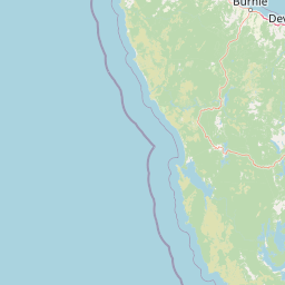
Map view of Savage River National Park

Use this park location map to pinpoint Savage River National Park in Australia, understand its exact geographic position, and read its mapped placement within the surrounding landscape more clearly.

Pigeon | © OpenStreetMap contributors

Location context for Savage River National Park

Tasmania
Park atlas

Map the regional spread of protected areas and wild river systems across Tasmania

Discover Nearby National Parks and Protected Landscapes Around Savage River National Park
Browse other national parks and protected areas adjacent to Savage River National Park, tracing their geographic distribution and shared temperate rainforest ecosystems within Tasmania. Explore these diverse conservation landscapes, including buttongrass moorlands and old-growth forests, to understand the broader regional context of protected wilderness in Australia.
National parkTasmania

Rocky Cape National Park: Tasmania's Coastal National Park with Ancient Aboriginal Heritage

Explore the dramatic headland, heath ecosystems, and mapped park boundaries.

Rocky Cape National Park on Tasmania's North West Coast is a nationally significant protected area recognized for its ancient Aboriginal archaeological heritage, representing at least 8,000 years of continuous occupation. The park's landscape unfolds across a dramatic coastal headland, featuring rugged rocky shores, expansive heathlands, and coastal woodlands that define this wild section of Tasmania. Its protected status underscores its importance for both cultural discovery and the preservation of unique Australian coastal ecosystems. Understanding Rocky Cape National Park offers direct insight into the region's geography and the enduring legacy of its first peoples.

Area
30.64 km²
Established
1967
IUCN
II
Relief
Lowland
National parkTasmania

Cradle Mountain, Lake St Clair National Park: Tasmania's Mapped Protected Landscape and Geography

Explore national park boundaries and regional natural terrain.

Gain insight into Cradle Mountain, Lake St Clair National Park, a protected national park in Tasmania, Australia. This entry provides a foundational understanding of its mapped terrain, geographic setting, and protected area status. Delve into the specific landscape characteristics that define this significant conservation zone and its place within the national atlas.

Area
1,614.43 km²
Established
1922
IUCN
II
Visitors
209K annual
National parkTasmania

Mole Creek Karst National Park: Mapped Protected Area and Tasmanian Landscape Atlas

Explore the geography and park boundaries within Tasmania's protected lands.

Mole Creek Karst National Park stands as a key protected area within Tasmania, offering a unique glimpse into the island state's natural geography. This resource facilitates an atlas-style discovery of the park's mapped landscape, its protected boundaries, and its significance within the broader context of Australian protected lands. Understand the park's terrain and its role in the region's conservation heritage.

Area
13.45 km²
Established
1996
IUCN
II
Relief
Mountain
National parkTasmania

Walls of Jerusalem National Park: A Mapped Alpine Wilderness in Tasmania

Explore protected landscapes with biblical place names.

Walls of Jerusalem National Park in Tasmania is a distinguished national park characterized by its rugged alpine terrain and dramatic quartzite formations, most notably King Davids Peak. The park's landscape is further distinguished by a unique series of features named after biblical locations, offering an evocative exploration for those interested in geographic discovery. As a protected wilderness area within the Tasmanian Wilderness World Heritage Area, it provides valuable insight into Australia's significant natural landscapes and their mapped representation.

Area
518 km²
Established
1978
IUCN
II
Relief
Mountain
National parkTasmania

Narawntapu National Park: Tasmania's Coastal Protected Landscape and Wildlife Atlas

Explore mapped boundaries, heathland, woodland, and intertidal bird habitats.

Narawntapu National Park showcases a remarkable protected coastal landscape on Tasmania's north coast, renowned for its exceptional density of marsupial wildlife and significant intertidal bird populations. Its diverse terrain, including heathland, woodland, and extensive mudflats, offers unique opportunities for geographic discovery and understanding the park's ecological importance. Examine its mapped natural features and protected status within the broader atlas of Australian reserves.

Area
43.49 km²
Established
1976
IUCN
II
Visitors
10.1K annual
National parkTasmania

Mount Field National Park: Explore Tasmania's Protected Landscape and Geographic Identity

Mapped terrain and regional atlas context for this Australian national park.

Mount Field National Park serves as a cornerstone of protected natural landscapes in Tasmania, Australia. This entry provides detailed geographic context, focusing on its mapped boundaries and distinct environmental setting. Users can explore its identity as a national park, understand its regional placement within Tasmania, and gain insight into the mapped terrain that defines this significant protected area. It is designed for atlas-based discovery of the park's landscape characteristics.

Area
162.65 km²
Established
1916
IUCN
II
Relief
Mountain
National parkTasmania

Southwest National Park: Tasmania's Core Wilderness National Park and World Heritage Landscape

Mapping the remote buttongrass moorlands and rugged terrain of this expansive park.

Southwest National Park represents a significant protected area in Tasmania, Australia, spanning over 6,183 square kilometers. As the heart of the Tasmanian Wilderness World Heritage Area, it showcases an extraordinary landscape characterized by vast buttongrass moorlands, ancient temperate rainforests, and dramatic mountainous terrain. This park is vital for its wilderness character and conservation significance, offering a unique opportunity to explore one of the Southern Hemisphere's last remaining untouched temperate wildernesses through its mapped geography and protected boundaries.

Area
6,182.67 km²
Established
1968
IUCN
II
Relief
Mountain
National parkTasmania

Hartz Mountains National Park: Tasmania's National Park Protected Landscape

Mapped geography and regional landscape context.

Delve into the specific protected landscape identity of Hartz Mountains National Park, situated in Tasmania, Australia. This page provides a detailed geographic breakdown, focusing on mapped park boundaries and its unique regional setting. Understand the atlas value of this national park by exploring its terrain and its role within Tasmania's broader conservation landscape.

Area
71.4 km²
Established
1939
IUCN
II
Visitors
11.8K annual

Common questions about visiting, size, designation, and location context for Savage River National Park

Savage River National Park FAQs for park facts, access, geography, and protected area context
Find quick answers about Savage River National Park, including protected-area facts, park geography, trail and visitor context, and how the park fits into its surrounding country and regional landscape.
MoriAtlas Explorer

Continue Your Protected Areas Search Across the Global Atlas

Deepen your exploration by continuing the structured search for national parks and protected areas worldwide. Utilize the comprehensive filtering capabilities to compare different conservation landscapes and refine your understanding of global park geography. Discover more about the distribution and characteristics of protected natural areas.

Global natural geography