

Mori Atlas logo
National parkMount Field National Park

Discover the mapped terrain and regional context of this Australian national park.

Mount Field National Park: Tasmania's Protected Landscape Identity and Geographic Boundaries

Mount Field National Park represents a significant protected area within the island state of Tasmania, Australia. This page offers an atlas-focused exploration of its geographic scope, detailing its mapped boundaries and the surrounding natural landscape context. Understand the park's identity as a distinct national park and its place within Tasmania's broader geography, serving as a gateway to structured discovery of its terrain and protected land characteristics.

Temperate RainforestAlpine EnvironmentGlacial LakesWaterfallsWorld Heritage AreaTasmanian Wildlife

Mount Field National Park

National park

Park overview

Structured park overview, official facts, and landscape profile for Mount Field National Park

Mount Field National Park park facts, protected area profile, and essential visitor context
Review the core facts for Mount Field National Park, including designation, size, terrain, visitor scale, habitats, and operating context in one park-focused overview.

About Mount Field National Park

Mount Field National Park represents one of Tasmania's premier protected landscapes, offering visitors an extraordinary diversity of ecosystems within a single protected area. The park's elevational range from dense rainforest valleys to alpine peaks creates distinct ecological zones that support different plant communities, animal life, and scenic character throughout the year. The lower slopes feature towering eucalyptus forests, including the impressive swamp gums along the Tall Trees Walk, while higher elevations reveal the stark beauty of alpine moorland shaped by ancient glacial processes. The park's inclusion in the Tasmania Wilderness World Heritage Area underscores its international significance as a representation of Australia's natural heritage. Visitors to the park can explore well-maintained walking tracks ranging from easy boardwalk walks to challenging multi-day treks to the summit peaks, while the visitor center provides interpretive context about the park's ecology, geology, and cultural history.

Quick facts and research context for Mount Field National Park

Mount Field National Park is situated in Tasmania, Australia, about 64 kilometers northwest of Hobart. The park covers 162.65 square kilometers and was established in 1916, making it one of Tasmania's oldest national parks alongside Freycinet National Park. The terrain spans from temperate rainforest at lower elevations to alpine moorland and glacial features at higher altitudes. The park is managed by the Tasmania Parks and Wildlife Service and forms part of the UNESCO World Heritage-listed Tasmania Wilderness area. Notable features include the Russell Falls, a series of glacial tarns, and Mount Field West as the highest peak.

Park context

Deeper park guide and search-rich context for Mount Field National Park

Mount Field National Park history, landscape, wildlife, and travel context
Explore Mount Field National Park through its history, landscape character, ecosystems, wildlife, conservation priorities, cultural context, and seasonal travel timing in a structured park guide built for atlas discovery and search intent.

Why Mount Field National Park stands out

Mount Field National Park is best known for its extraordinary ecological range, encompassing one of Tasmania's finest examples of temperate rainforest alongside alpine moorland and glacial landscapes. The park contains the famous Russell Falls, a striking three-tiered waterfall that has attracted visitors since the late 19th century. The Tarn Shelf area showcases a remarkable sequence of glacial tarns including Robert Tarn, Mackenzie Tarn, and Johnston Tarn, set against the dramatic backdrop of the park's highest peaks. The park also supports significant populations of Tasmania's iconic wildlife including the Tasmanian devil, as well as being historically significant as the site where the last known wild thylacine was captured in 1933.

Mount Field National Park history and protected-area timeline

Mount Field National Park has a distinguished place in Australian conservation history as one of Tasmania's oldest national parks, founded in 1916 alongside Freycinet National Park. The origins of protection in the area predate the formal national park designation, however, with the spectacular Russell Falls region set aside as Tasmania's first nature reserve as early as 1885, recognizing its outstanding natural beauty. The area held historical significance beyond its scenic value, as the last known wild thylacine (Tasmanian tiger) was captured in the region in 1933, marking the end of a species that once roamed the Australian mainland. The reserve carried the designation of National Park before the official renaming occurred in 1947, when it received its present name honoring Judge Barron Field, who visited Tasmania as an itinerant judge in 1819 and 1821. The park's establishment reflected the growing appreciation in the early 20th century for preserving natural landscapes for future generations.

Mount Field National Park landscape and geographic character

The landscape of Mount Field National Park exhibits remarkable topographical and geological diversity shaped by Pleistocene glacial processes. The park's central feature is the Mount Field plateau, which was capped by a snowfield during the Pleistocene epoch, with glaciers flowing through surrounding valleys and carving the distinctive glacial features visible today. A large glacier extending 12 kilometers formed the broad river valley and the dramatic cirque walls that enclose Lake Seal. The famous Tarn Shelf area displays a sequence of glacial tarns including Twisted Tarn, Twilight Tarn, Robert Tarn, Mackenzie Tarn, and Johnston Tarn, formed by glacial scouring. Additional glacial valleys from the Rodway Range contain lakes Belcher and Belton, while northward-flowing glaciers created Hayes Valley and Lake Hayes. The park rises to 1,434 meters at Mount Field West, with alpine areas featuring podzolic, humus, and leached soils, while alluvial floodplains have developed in lower sections.

Mount Field National Park ecosystems, habitats, and plant life

The ecological character of Mount Field National Park is defined by its extraordinary altitudinal range, which supports distinct vegetation zones from temperate rainforest to alpine communities. The lower elevations feature Tasmania's characteristic eucalyptus forests, with the tall swamp gums (Eucalyptus regnans) forming impressive forest canopies along the Tall Trees Walk. Above the treeline, alpine moorland dominates with heathland vegetation adapted to harsh mountain conditions. The park's soils reflect this diversity, with alpine areas displaying podzolic, humus, and leached soils often on deep periglacial deposits, while lower floodplains contain alluvial soils developed on Quaternary alluvium. The park also supports remarkable fungal diversity, with 289 species already recorded, including ecologically important mycorrhizal species that form symbiotic relationships with the majority of the park's plant species. These fungi play vital roles in nutrient cycling and ecosystem functioning.

Mount Field National Park wildlife and species highlights

Mount Field National Park provides habitat for a representative cross-section of Tasmania's native fauna, including several species iconic to the island. The park supports populations of wombats, which are commonly encountered in forested areas, as well as platypuses in the park's streams and waterways. Eastern barred bandicoots, echidnas, and the endangered Tasmanian devil all occur within the park boundaries, representing Tasmania's distinctive mammalian fauna. The park's ecological significance extends to the broader conservation context, as the last known wild thylacine was captured in the region in 1933, marking the end of this once-widespread marsupial. The diverse habitats within the park, ranging from rainforest to alpine zones, support different faunal communities across elevations.

Mount Field National Park conservation status and protection priorities

Mount Field National Park holds significant conservation value as part of the UNESCO World Heritage-listed Tasmania Wilderness, recognized under both cultural and natural criteria. The park protects representative examples of Tasmania's unique ecosystems, from temperate rainforest to alpine environments, that have evolved in isolation on the island continent. The establishment of the park in 1916 reflected early recognition of the need to preserve outstanding natural landscapes, following the designation of the Russell Falls area as a nature reserve in 1885. Management by the Tasmania Parks and Wildlife Service addresses challenges including the impact of invasive Phytophthora cinnamomi fungus on some areas. The park's protected status ensures the preservation of both its ecological communities and its geological heritage, including the significant glacial landforms that document Pleistocene climatic conditions.

Mount Field National Park cultural meaning and human context

Mount Field National Park carries cultural significance through its connection to Judge Barron Field, after whom the park is named. Judge Field visited Tasmania in 1819 and 1821 in his capacity as an itinerant judge, and his association with the region led to the naming of the mountain and subsequently the protected area. The park also holds significance in the broader narrative of Australian conservation history, representing some of the earliest efforts to protect natural areas in Tasmania. The park's landscape has been shaped by both natural processes over millions of years and by the historical human use of the region, from early European visitors to the establishment of conservation protections.

Top sights and standout views in Mount Field National Park

Mount Field National Park offers visitors several standout experiences that showcase the park's natural diversity. Russell Falls, an easy walk from the visitor center, presents a striking three-tiered waterfall that has captivated visitors since the late 19th century and remains one of Tasmania's most iconic natural attractions. The Tarn Shelf area provides access to a remarkable sequence of glacial lakes surrounded by alpine scenery, accessible via challenging walking tracks that reward visitors with views of tarns including Lake Newdegate and Twilight Tarn. The Tall Trees Walk passes through forest featuring some of Tasmania's tallest eucalyptus trees, while more adventurous hikers can undertake the summit walks to Mount Field West or Mount Field East. During winter months, the park's ski area on Mount Mawson and the Rodway Range offers downhill skiing opportunities, making Mount Field a year-round destination.

Best time to visit Mount Field National Park

Mount Field National Park offers rewarding experiences across all seasons, though each period presents different conditions and attractions. The summer months of December through February typically provide the most reliable conditions for extended walking and exploring the higher-elevation tracks, with longer daylight hours allowing for full-day hikes to the Tarn Shelf or summit peaks. Autumn often brings clear skies and vibrant colors to the deciduous beech trees in the area, while winter transforms the higher elevations into a skiing destination with generally sufficient snow cover from mid-July to mid-September. Spring brings wildflower displays in the alpine areas and increased water flows to the waterfalls. The lower-elevation walks to Russell Falls and through the rainforest can be enjoyed year-round, though visitors should be prepared for Tasmania's changeable weather conditions at any time of year.
Park location guide

Geography guide, regional context, and park location map for Mount Field National Park

Mount Field National Park park geography, regions, and map view in Australia
Understand where Mount Field National Park sits in Australia through a broader geographic reading of the surrounding landscape, nearby location context, and its mapped position within the national park landscape.

How Mount Field National Park fits into Australia

Australia is a constitutional monarchy and federal parliamentary democracy comprising six states and ten territories. With a population of nearly 28 million, it is one of the world's most urbanised countries, with most people concentrated on the eastern seaboard. The country has a high Human Development Index and is known for its cultural diversity, ancient Aboriginal heritage, and unique wildlife.

Wider geography shaping Mount Field National Park in Australia

Australia occupies the entire Australian continent, the island of Tasmania, and numerous smaller islands. It is the world's flattest and driest inhabited continent, featuring vast deserts in the interior (the Outback), tropical rainforests along the eastern coast, and a coastline bordering the Indian and Pacific Oceans.

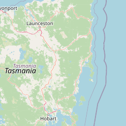
Map view of Mount Field National Park

Use this park location map to pinpoint Mount Field National Park in Australia, understand its exact geographic position, and read its mapped placement within the surrounding landscape more clearly.

Pigeon | © OpenStreetMap contributors

Location context for Mount Field National Park

Tasmania
Park atlas

Compare regional protected landscapes and diverse ecosystems surrounding Mount Field National Park across Tasmania's wilderness geography.

Explore Other National Parks and Protected Areas Near Mount Field National Park, Tasmania
After exploring Mount Field National Park, browse an expanded selection of nearby national parks and significant protected areas to trace Tasmania's diverse ecological spread. Compare alpine environments, glacial features, and temperate rainforests within their regional context, offering deeper atlas-style discovery of connected conservation landscapes.
National parkTasmania

Southwest National Park: Tasmania's Core Wilderness National Park and World Heritage Landscape

Mapping the remote buttongrass moorlands and rugged terrain of this expansive park.

Southwest National Park represents a significant protected area in Tasmania, Australia, spanning over 6,183 square kilometers. As the heart of the Tasmanian Wilderness World Heritage Area, it showcases an extraordinary landscape characterized by vast buttongrass moorlands, ancient temperate rainforests, and dramatic mountainous terrain. This park is vital for its wilderness character and conservation significance, offering a unique opportunity to explore one of the Southern Hemisphere's last remaining untouched temperate wildernesses through its mapped geography and protected boundaries.

Area
6,182.67 km²
Established
1968
IUCN
II
Relief
Mountain
National parkTasmania

Hartz Mountains National Park: Tasmania's National Park Protected Landscape

Mapped geography and regional landscape context.

Delve into the specific protected landscape identity of Hartz Mountains National Park, situated in Tasmania, Australia. This page provides a detailed geographic breakdown, focusing on mapped park boundaries and its unique regional setting. Understand the atlas value of this national park by exploring its terrain and its role within Tasmania's broader conservation landscape.

Area
71.4 km²
Established
1939
IUCN
II
Visitors
11.8K annual
National parkTasmania

Walls of Jerusalem National Park: A Mapped Alpine Wilderness in Tasmania

Explore protected landscapes with biblical place names.

Walls of Jerusalem National Park in Tasmania is a distinguished national park characterized by its rugged alpine terrain and dramatic quartzite formations, most notably King Davids Peak. The park's landscape is further distinguished by a unique series of features named after biblical locations, offering an evocative exploration for those interested in geographic discovery. As a protected wilderness area within the Tasmanian Wilderness World Heritage Area, it provides valuable insight into Australia's significant natural landscapes and their mapped representation.

Area
518 km²
Established
1978
IUCN
II
Relief
Mountain
National parkTasmania

Cradle Mountain, Lake St Clair National Park: Tasmania's Mapped Protected Landscape and Geography

Explore national park boundaries and regional natural terrain.

Gain insight into Cradle Mountain, Lake St Clair National Park, a protected national park in Tasmania, Australia. This entry provides a foundational understanding of its mapped terrain, geographic setting, and protected area status. Delve into the specific landscape characteristics that define this significant conservation zone and its place within the national atlas.

Area
1,614.43 km²
Established
1922
IUCN
II
Visitors
209K annual
National parkTasmania

Tasman National Park: Discover Its National Park Geography and Protected Landscape

Explore mapped boundaries and regional context within Tasmania.

Tasman National Park represents a key protected area for exploration within Tasmania's distinctive geography. This page facilitates a detailed look at its national park identity, focusing on its mapped natural landscapes and its contribution to the protected area network of the Australian island state. Gain structured geographic insight into this significant conservation landscape.

Area
107.5 km²
Established
1999
IUCN
II
Relief
Mixed relief
National parkTasmania

Mole Creek Karst National Park: Mapped Protected Area and Tasmanian Landscape Atlas

Explore the geography and park boundaries within Tasmania's protected lands.

Mole Creek Karst National Park stands as a key protected area within Tasmania, offering a unique glimpse into the island state's natural geography. This resource facilitates an atlas-style discovery of the park's mapped landscape, its protected boundaries, and its significance within the broader context of Australian protected lands. Understand the park's terrain and its role in the region's conservation heritage.

Area
13.45 km²
Established
1996
IUCN
II
Relief
Mountain
National parkTasmania

Freycinet National Park: Iconic Granite Peaks and Protected Coastal Landscape in Tasmania

Mapped geography and distinct terrain of Tasmania's historic national park.

Freycinet National Park on Tasmania's east coast is a remarkable protected landscape defined by its dramatic granite mountains, including The Hazards, and the pristine Wineglass Bay. Established as one of Tasmania's first national parks, it showcases unique geological formations and coastal ecosystems across its rugged terrain. This detailed view provides an atlas-style exploration of its mapped boundaries and geographic significance within the regional context.

Area
169 km²
Established
1916
IUCN
II
Visitors
200K annual
Watercolor illustration of a landscape featuring hills, trees, and a winding river
National parkTasmania

Douglas-Apsley National Park: Discover its Protected Landscape and Geographic Context in Tasmania

Mapped boundaries and regional terrain of a key Tasmanian national park.

Delve into the geographic details of Douglas-Apsley National Park, a designated national park situated in Tasmania, Australia. This entry provides insight into the park's protected landscape identity, its mapped boundaries, and its contribution to the rich regional geography of Tasmania. Understanding its place within the island's natural terrain is crucial for comprehensive atlas-driven exploration and appreciating Australia's protected areas.

Area
160.8 km²
Established
1989
IUCN
II
Relief
Upland

Common questions about visiting, size, designation, and location context for Mount Field National Park

Mount Field National Park FAQs for park facts, access, geography, and protected area context
Find quick answers about Mount Field National Park, including protected-area facts, park geography, trail and visitor context, and how the park fits into its surrounding country and regional landscape.
MoriAtlas Explorer

Continue Your Protected Areas Search Across the Global Atlas

Deepen your exploration by continuing the structured search for national parks and protected areas worldwide. Utilize the comprehensive filtering capabilities to compare different conservation landscapes and refine your understanding of global park geography. Discover more about the distribution and characteristics of protected natural areas.

Global natural geography