Mori Atlas logo
National parkDouglas-Apsley National Park

Discover the mapped boundaries and regional terrain of this significant national park.

Douglas-Apsley National Park: Tasmania's Protected Landscape and Geographic Identity

Douglas-Apsley National Park stands as a protected landscape within the island state of Tasmania, Australia. This page serves as an entry point for understanding its specific geographic setting and its role within the island's extensive network of protected areas. Users can explore the park's mapped boundaries and understand its contribution to Tasmania's unique regional geography and natural terrain.

dry sclerophyll forestdeep gorgesendemic birdseast coast TasmaniaImportant Bird Areanature reserves
Illustration of a calm river reflecting mountains and trees under a partly cloudy sky

Douglas-Apsley National Park

National park

Park overview

Structured park overview, official facts, and landscape profile for Douglas-Apsley National Park

Douglas-Apsley National Park park facts, protected area profile, and essential visitor context
Review the core facts for Douglas-Apsley National Park, including designation, size, terrain, visitor scale, habitats, and operating context in one park-focused overview.

About Douglas-Apsley National Park

Douglas-Apsley National Park occupies a distinctive position in Tasmania's protected area network as one of the few reserves protecting the island's east coast dry forest ecosystem. Located along a transition zone between the wetter western forests and the drier coastal plains, the park encompasses rugged terrain characterized by steep ridges, deep valleys, and the distinctive watercourses that give the park its name. The dry sclerophyll forest that dominates the landscape features a canopy of stringybark and peppermint eucalypts, with a diverse understory of shrubs, grasses, and flowering plants that change with the seasons. Three perennial streams bisect the park, providing permanent water sources and creating the riparian corridors that support distinct plant communities. The park's relatively recent establishment in 1989 reflects a growing recognition of the ecological importance of protecting Tasmania's less publicized dry forest habitats, which had historically received less conservation attention than the island's wetter wilderness areas.

Quick facts and research context for Douglas-Apsley National Park

Douglas-Apsley National Park is located on Tasmania's east coast near Bicheno, approximately 149 kilometers northeast of Hobart. The 160.8 square kilometer park was established in 1989 and is managed by the Tasmania Parks and Wildlife Service. It protects dry forest catchment areas feeding the Apsley River, Denison Rivulet, and Douglas River. The park features deep gorges, wildflower-rich woodlands, and a mild climate compared to other parts of Tasmania. Visitors can explore short walking tracks or undertake a multi-day trek through the park's interior.

Park context

Deeper park guide and search-rich context for Douglas-Apsley National Park

Douglas-Apsley National Park history, landscape, wildlife, and travel context
Explore Douglas-Apsley National Park through its history, landscape character, ecosystems, wildlife, conservation priorities, cultural context, and seasonal travel timing in a structured park guide built for atlas discovery and search intent.

Why Douglas-Apsley National Park stands out

Douglas-Apsley National Park is best known for its exceptional dry forest ecosystem, which represents a relatively rare habitat type in Tasmania's conservation estate. The park preserves some of the finest examples of east coast dry sclerophyll forest, characterized by towering eucalypts, diverse understory species, and an impressive display of wildflowers including triggerplants, wattles, and grass-trees. The deeply incised gorges carved by the park's three main watercourses create visually striking landscapes with exposed rock faces, small waterfalls, and shaded riparian zones. The park's significance as an Important Bird Area, supporting eleven of Tasmania's endemic bird species, further establishes its conservation value.

Calm river reflecting rocky hills and dense forest under clear sky
Scenic river view reflecting forested hills in Douglas-Apsley National Park

Douglas-Apsley National Park history and protected-area timeline

Douglas-Apsley National Park was officially declared on December 27, 1989, making it one of the newer additions to Tasmania's national park system. The establishment of the park followed surveys and advocacy that highlighted the ecological significance of the east coast dry forests, which had been subject to partial clearing for agriculture and timber extraction in preceding decades. The park was named for the Douglas River and the Apsley River, two of the primary watercourses flowing through the area and feeding into the park's catchments. The creation of the park protected what remained of a largely intact dry forest landscape that had survived relatively minor disturbance compared to other east coast areas. The Tasmania Parks and Wildlife Service assumed management responsibility, implementing a conservation-focused approach that balanced public access with habitat protection.

Douglas-Apsley National Park landscape and geographic character

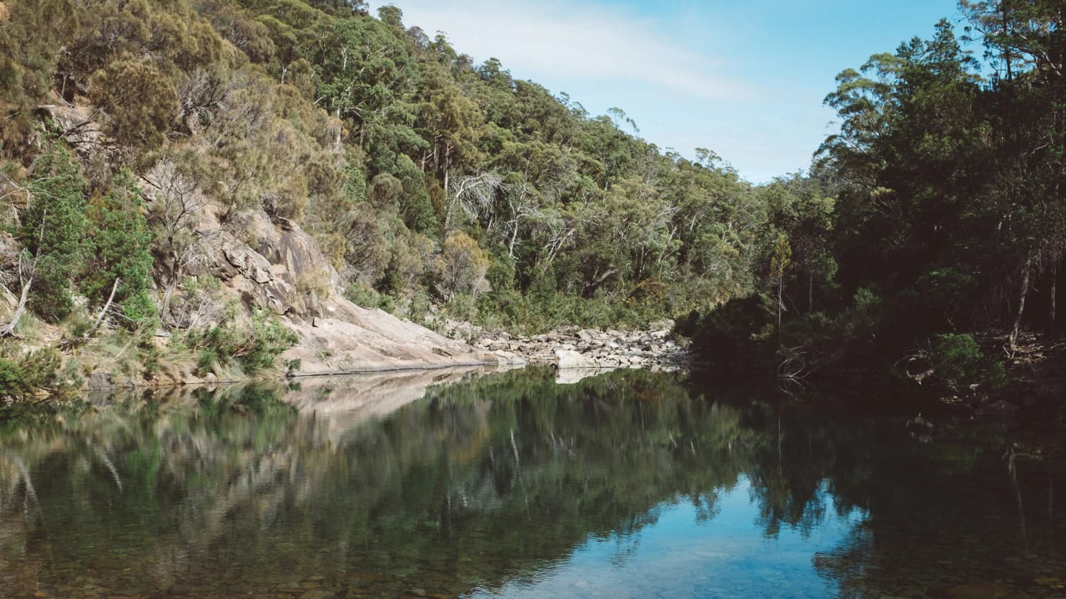
The landscape of Douglas-Apsley National Park is defined by a series of steep ridgelines and deep gorges carved into the ancient geological formations of the east coast. The terrain rises from the valley floors where the Apsley River, Denison Rivulet, and Douglas River flow, creating a complex topography of cliff faces, rock ledges, and cascading water. The dry sclerophyll forest dominates the slopes and ridges, with exposed granite and dolerite outcrops adding visual interest throughout the park. The valley floors support gallery forests along the watercourses, where taller trees and denser vegetation create a contrast with the more open woodland on the ridges. Seasonal wildflower displays transform the understory, particularly in spring and early summer, with displays of purple, yellow, and white flowers providing seasonal color.

Douglas-Apsley National Park ecosystems, habitats, and plant life

The ecological character of Douglas-Apsley centers on its dry sclerophyll forest ecosystem, which supports a distinctive suite of plant and animal species adapted to the relatively drier conditions of Tasmania's east coast. The forest canopy is dominated by various eucalypt species including messmate, stringybark, and Tasmanian peppermint, with an understory that varies from dense shrubland to more open grassy areas depending on aspect and soil conditions. The park's three permanent streams provide critical habitat for aquatic species and maintain riparian zones that support different plant communities than the surrounding slopes. The forest structure provides nesting and foraging habitat for numerous bird species, while the diverse plant community supports invertebrate populations that form the base of the food web. The combination of forest, rock, and water habitats creates a mosaic of environments supporting the park's biodiversity.

Douglas-Apsley National Park wildlife and species highlights

Douglas-Apsley National Park has been identified by BirdLife International as an Important Bird Area, recognizing its exceptional significance for bird conservation. The park supports eleven of Tasmania's endemic bird species, making it a critically important location for birds found nowhere else on Earth. Notable species include the endangered swift parrot, which migrates to the Australian mainland in winter but breeds in Tasmania's eucalypt forests during the warmer months. The flame robin and pink robin add color to the forest understory, while a range of honeyeaters, parrots, and cockatoos exploit the seasonal nectar resources. The park's streams provide habitat for platypus and various fish species, while the forest canopy and ground layer support populations of possums, wallabies, and bandicoots.

Douglas-Apsley National Park conservation status and protection priorities

The protection of Douglas-Apsley National Park represents an important contribution to Tasmania's conservation network, specifically addressing the under-representation of dry forest ecosystems in the protected area system. The park's designation as an Important Bird Area by BirdLife International highlights its global significance for threatened bird species, particularly the swift parrot which is listed as endangered. The dry forest ecosystem has been significantly altered across its former range by clearing for agriculture and forestry, making the relatively intact landscapes within Douglas-Apsley increasingly valuable for biodiversity conservation. The park also protects water catchments that feed into downstream ecosystems, contributing to broader landscape-scale conservation across the east coast region.

Douglas-Apsley National Park cultural meaning and human context

Douglas-Apsley National Park lies within the traditional Country of Tasmanian Aboriginal peoples, who have lived on the island for tens of thousands of years. The park's rivers and forested landscapes would have supported Aboriginal communities through the provision of food, water, and materials for tools and shelters. While the park does not contain widely publicized archaeological sites, the broader Tasmanian landscape holds evidence of Aboriginal occupation throughout the region. European settlement of the east coast brought clearing for agriculture and limited timber extraction, though the dry forests of the Douglas-Apsley area remained relatively intact compared to other regions. The park's establishment in 1989 marked a shift toward recognizing the value of both natural and cultural heritage in conservation planning.

Top sights and standout views in Douglas-Apsley National Park

The deep gorges of the Apsley River, Denison Rivulet, and Douglas River rank among the park's most striking features, offering scenic beauty and opportunities for exploration. The seasonal wildflower displays transform the forest understory, particularly in spring when triggerplants, wattles, and other wildflowers bloom across the park. The network of walking tracks ranges from short easy walks suitable for families to a challenging three-day trek for experienced bushwalkers seeking a deeper wilderness experience. The birdlife, especially the endemic species and the chance to spot swift parrots, flame robins, and pink robins, draws visitors with specific interest in Tasmania's avifauna.

Best time to visit Douglas-Apsley National Park

The park can be visited year-round, though the mild east coast climate makes autumn and spring particularly appealing seasons. Spring brings the most spectacular wildflower displays as the understory bursts into color, while autumn offers comfortable walking conditions and often clear skies. Summer months can be warm but the forest provides shade along the tracks, while winter brings cooler temperatures and potentially muddy conditions on lower-elevation trails. The chance to observe birds is good throughout the year, though swift parrots are most reliably seen during the breeding season from late summer to autumn.

Park location guide

Geography guide, regional context, and park location map for Douglas-Apsley National Park

Douglas-Apsley National Park park geography, regions, and map view in Australia
Understand where Douglas-Apsley National Park sits in Australia through a broader geographic reading of the surrounding landscape, nearby location context, and its mapped position within the national park landscape.

How Douglas-Apsley National Park fits into Australia

Australia is a constitutional monarchy and federal parliamentary democracy comprising six states and ten territories. With a population of nearly 28 million, it is one of the world's most urbanised countries, with most people concentrated on the eastern seaboard. The country has a high Human Development Index and is known for its cultural diversity, ancient Aboriginal heritage, and unique wildlife.

Wider geography shaping Douglas-Apsley National Park in Australia

Australia occupies the entire Australian continent, the island of Tasmania, and numerous smaller islands. It is the world's flattest and driest inhabited continent, featuring vast deserts in the interior (the Outback), tropical rainforests along the eastern coast, and a coastline bordering the Indian and Pacific Oceans.

Map view of Douglas-Apsley National Park

Use this park location map to pinpoint Douglas-Apsley National Park in Australia, understand its exact geographic position, and read its mapped placement within the surrounding landscape more clearly.

Pigeon | © OpenStreetMap contributors

Location context for Douglas-Apsley National Park

Tasmania

Discover the unique dry sclerophyll forest, rugged terrain, and river gorges that define this significant Tasmanian protected area through compelling imagery.

Explore Douglas-Apsley National Park Photos: Visualizing Tasmania's Dry Forest Landscapes and Gorges
Browse an immersive visual gallery of Douglas-Apsley National Park to understand its distinctive dry forest ecosystems, deeply carved river gorges, and the seasonal wildflower displays that color its rugged Tasmanian landscape. These protected area images provide essential insight into the park's varied terrain, endemic habitats, and the unique conservation character that sets it apart on Tasmania's east coast.

Calm river reflecting rocky hills and dense forest under clear sky

Park atlas

Trace the regional spread of parks, comparing diverse dry forest ecosystems and coastal protected areas.

Discover Other National Parks and Protected Areas Surrounding Douglas-Apsley National Park
Explore national parks and other protected areas geographically situated near Douglas-Apsley National Park, revealing the broader regional context of Tasmania's unique dry forest ecosystems and coastal landscapes. Compare diverse park features and understand the interconnected network of protected land, enabling deeper atlas discovery and comprehensive geographic comparisons.
National parkTasmania

Freycinet National Park: Iconic Granite Peaks and Protected Coastal Landscape in Tasmania

Mapped geography and distinct terrain of Tasmania's historic national park.

Freycinet National Park on Tasmania's east coast is a remarkable protected landscape defined by its dramatic granite mountains, including The Hazards, and the pristine Wineglass Bay. Established as one of Tasmania's first national parks, it showcases unique geological formations and coastal ecosystems across its rugged terrain. This detailed view provides an atlas-style exploration of its mapped boundaries and geographic significance within the regional context.

Area
169 km²
Established
1916
IUCN
II
Visitors
200K annual
National parkTasmania

Mount William National Park: Protected Landscape and National Park Atlas Details

Discover mapped geography and protected area context within Tasmania.

Mount William National Park stands as a vital protected area within Tasmania's vast network of natural landscapes. This detailed entry focuses on its identity as a national park, providing essential geographic context and mapped boundaries for atlas exploration. Understanding Mount William National Park's place in Tasmania's regional geography allows for a richer appreciation of Australia's protected lands.

Area
184.39 km²
Established
1973
IUCN
II
Relief
Lowland
National parkTasmania

Tasman National Park: Discover Its National Park Geography and Protected Landscape

Explore mapped boundaries and regional context within Tasmania.

Tasman National Park represents a key protected area for exploration within Tasmania's distinctive geography. This page facilitates a detailed look at its national park identity, focusing on its mapped natural landscapes and its contribution to the protected area network of the Australian island state. Gain structured geographic insight into this significant conservation landscape.

Area
107.5 km²
Established
1999
IUCN
II
Relief
Mixed relief
National parkTasmania

Narawntapu National Park: Tasmania's Coastal Protected Landscape and Wildlife Atlas

Explore mapped boundaries, heathland, woodland, and intertidal bird habitats.

Narawntapu National Park showcases a remarkable protected coastal landscape on Tasmania's north coast, renowned for its exceptional density of marsupial wildlife and significant intertidal bird populations. Its diverse terrain, including heathland, woodland, and extensive mudflats, offers unique opportunities for geographic discovery and understanding the park's ecological importance. Examine its mapped natural features and protected status within the broader atlas of Australian reserves.

Area
43.49 km²
Established
1976
IUCN
II
Visitors
10.1K annual
National parkTasmania

Mole Creek Karst National Park: Mapped Protected Area and Tasmanian Landscape Atlas

Explore the geography and park boundaries within Tasmania's protected lands.

Mole Creek Karst National Park stands as a key protected area within Tasmania, offering a unique glimpse into the island state's natural geography. This resource facilitates an atlas-style discovery of the park's mapped landscape, its protected boundaries, and its significance within the broader context of Australian protected lands. Understand the park's terrain and its role in the region's conservation heritage.

Area
13.45 km²
Established
1996
IUCN
II
Relief
Mountain
National parkTasmania

Walls of Jerusalem National Park: A Mapped Alpine Wilderness in Tasmania

Explore protected landscapes with biblical place names.

Walls of Jerusalem National Park in Tasmania is a distinguished national park characterized by its rugged alpine terrain and dramatic quartzite formations, most notably King Davids Peak. The park's landscape is further distinguished by a unique series of features named after biblical locations, offering an evocative exploration for those interested in geographic discovery. As a protected wilderness area within the Tasmanian Wilderness World Heritage Area, it provides valuable insight into Australia's significant natural landscapes and their mapped representation.

Area
518 km²
Established
1978
IUCN
II
Relief
Mountain
National parkTasmania

Mount Field National Park: Explore Tasmania's Protected Landscape and Geographic Identity

Mapped terrain and regional atlas context for this Australian national park.

Mount Field National Park serves as a cornerstone of protected natural landscapes in Tasmania, Australia. This entry provides detailed geographic context, focusing on its mapped boundaries and distinct environmental setting. Users can explore its identity as a national park, understand its regional placement within Tasmania, and gain insight into the mapped terrain that defines this significant protected area. It is designed for atlas-based discovery of the park's landscape characteristics.

Area
162.65 km²
Established
1916
IUCN
II
Relief
Mountain
National parkTasmania

Strzelecki National Park: A National Park in Tasmania's Protected Landscape Atlas

Explore mapped park boundaries and regional terrain.

Strzelecki National Park represents a significant protected land entity within Tasmania, Australia. As a national park, it offers critical insights into the island state's diverse geography and landscape formations. This detailed view supports an atlas-based understanding, highlighting the park's mapped boundaries and its contribution to the structured exploration of Australia's protected areas. Discover the geographic characteristics and contextual importance of this Tasmanian natural landscape.

Area
42.16 km²
Established
1967
IUCN
II
Relief
Mixed relief

Common questions about visiting, size, designation, and location context for Douglas-Apsley National Park

Douglas-Apsley National Park FAQs for park facts, access, geography, and protected area context
Find quick answers about Douglas-Apsley National Park, including protected-area facts, park geography, trail and visitor context, and how the park fits into its surrounding country and regional landscape.
MoriAtlas Explorer

Continue Your Protected Areas Search Across the Global Atlas

Deepen your exploration by continuing the structured search for national parks and protected areas worldwide. Utilize the comprehensive filtering capabilities to compare different conservation landscapes and refine your understanding of global park geography. Discover more about the distribution and characteristics of protected natural areas.

Global natural geography