

Mori Atlas logo
Wildlife reserveBomfobiri Wildlife Sanctuary

Tracing the mapped boundaries and natural terrain of a sanctuary defined by forest, savanna, and cascading waterfalls.

Bomfobiri Wildlife Sanctuary: A Compressed Mosaic of Protected Landscapes in the Ashanti Region of Ghana

Bomfobiri Wildlife Sanctuary is an ecologically diverse protected area located roughly 80 kilometers northeast of Kumasi. The sanctuary presents a rare, compressed mosaic of four distinct vegetation types; riverine forest, rainforest, woodland savanna, and grassland savanna. Beyond its biological richness, the reserve features significant geological landmarks including the Lion Stone, natural stone bridges, caves, and dual waterfall systems that anchor the landscape within the Ashanti region.

bird sanctuaryriverine forestrainforestwoodland savannagrassland savannawildlife sanctuary

Bomfobiri Wildlife Sanctuary

Wildlife reserve

Park overview

Structured park overview, official facts, and landscape profile for Bomfobiri Wildlife Sanctuary

Bomfobiri Wildlife Sanctuary park facts, protected area profile, and essential visitor context

Review the core facts for Bomfobiri Wildlife Sanctuary, including designation, size, terrain, visitor scale, habitats, and operating context in one park-focused overview.

About Bomfobiri Wildlife Sanctuary

Bomfobiri Wildlife Sanctuary sits in the Ashanti region of Ghana, a region known for its forested landscapes and traditional cultural heritage. The sanctuary lies northeast of Kumasi, the regional capital and Ghana's second-largest city, making it accessible for day trips and short excursions from a major urban center. Although modest in scale compared with Ghana's larger savanna parks in the north, Bomfobiri stands out for packing four ecologically distinct habitat types into a single protected area.

The reserve's defining ecological strength lies in habitat variety. Riverine forest traces the park's waterways, supporting dense, moisture-loving vegetation and wildlife; rainforest patches echo the wetter equatorial forests of West Africa; woodland savanna introduces more open canopy and drier conditions; and grassland savanna creates the lightest habitat type. This gradient from shaded riverside vegetation to open grassy areas within a relatively short distance gives Bomfobiri an unusually rich ecological profile.

Beyond its biological role, the sanctuary incorporates several striking natural landmarks that have cultural resonance. The Lion Stone is a naturally shaped rock that resembles a lion, and the Stone Bridge is another geological feature of interest. Two waterfalls add a recreational and scenic dimension: the Bomfobiri waterfall, around which crocodiles congregate, and the Wala waterfall, used by visitors for swimming. Caves within the sanctuary further expand its character. Taken together, these features position Bomfobiri as a place where varied ecosystems, distinctive geological landmarks, and outdoor recreation intersect.

The sanctuary was originally created within the earlier Boumfum Forest Reserve in 1946 and was later expanded and redesignated in 1975 under Ghanaian wildlife legislation. That long protection history has allowed the area to retain its habitat heterogeneity and to support species that range from primates and ungulates to monitor lizards and crocodiles. The park is also a major attraction for birdwatching, contributing to Ghana's broader network of bird-focused protected areas.

Quick facts and research context for Bomfobiri Wildlife Sanctuary

Bomfobiri Wildlife Sanctuary is located roughly 80 kilometers northeast of Kumasi in the Ashanti region of Ghana, at coordinates approximately 06°54.595'N, 001°17.340'W. It spans about 53 square kilometers and was formally redesignated as a wildlife sanctuary in 1975, although its underlying forest reserve dates back to 1946.

The park protects four vegetation types: riverine forest, rainforest, woodland savanna, and grassland savanna, creating a mosaic habitat in a compact area. It is classified primarily as a bird sanctuary and is also home to mammals such as crocodiles, baboons, Mona monkeys, buffalos, red river hogs, Maxwell's and red-flanked duikers, bushbuck, and monitor lizards. The crocodile functions as the sanctuary's symbolic species.

Park context

Deeper park guide and search-rich context for Bomfobiri Wildlife Sanctuary

Bomfobiri Wildlife Sanctuary history, landscape, wildlife, and travel context

Explore Bomfobiri Wildlife Sanctuary through its history, landscape character, ecosystems, wildlife, conservation priorities, cultural context, and seasonal travel timing in a structured park guide built for atlas discovery and search intent.

Why Bomfobiri Wildlife Sanctuary stands out

Bomfobiri Wildlife Sanctuary is best known for combining unusually high habitat diversity for its size, with four distinct vegetation zones meeting within a single reserve. It has a particular reputation as a bird sanctuary, supporting numerous bird species alongside a varied mammal community. The sanctuary is also recognized for its natural landmarks, including the Lion Stone, a naturally carved rock resembling a lion; a natural stone bridge; the Bomfobiri waterfall, where crocodiles can be observed; and the Wala waterfall, used for swimming. The crocodile is the reserve's official symbol, reinforcing the park's identity as a place where water-linked wildlife and dramatic geological features coexist.

Bomfobiri Wildlife Sanctuary history and protected-area timeline

The protected history of Bomfobiri Wildlife Sanctuary begins long before its current designation. The earliest formal protection of the area came on 23 March 1946, when the original Boumfum Forest Reserve was established under the Ashanti Authority Ordinance. At that time, the protected area covered only about 16.8 square kilometers, reflecting the narrower colonial-era boundaries focused on timber and forest resources within the Ashanti region.

In 1975, the reserve was significantly expanded and re-designated as Bomfobiri Wildlife Sanctuary. This redesignation occurred under the Wildlife Reserves (Amendment) Regulation, known as L.I. 1022, a legal framework that allowed Ghana to convert and broaden certain forest reserves into wildlife sanctuaries with a broader ecological mandate. The expansion established the present-day boundaries of the sanctuary and formalized its role in protecting not just timber resources but the full range of ecosystems and wildlife in the area.

The redesignation was intended specifically to safeguard the area's ecological values, including its rivers, the diverse habitats they support, and the wildlife living within them. Over time, this long period of continuous protection has shaped Bomfobiri's identity, enabling it to retain a mix of forest and savanna habitats uncommon within such a compact reserve.

Bomfobiri Wildlife Sanctuary landscape and geographic character

The landscape of Bomfobiri Wildlife Sanctuary is shaped by an unusually compressed mosaic of ecosystems for a protected area of its size. The terrain includes stretches of dense riverine forest that hug the park's waterways, where moisture-loving trees create a heavily shaded, ever-changing corridor along rivers and streams. These water-focused forests transition inland into broader stretches of rainforest with a more closed canopy, before opening out into the drier vegetation of woodland savanna.

Further into the reserve, the landscape transitions into grassland savanna, with shorter vegetation and more open sightlines, creating a sharp contrast to the dense forest interior. Within this varied terrain, waterfalls carve through the rock, most notably the Bomfobiri waterfall, associated with crocodile habitat, and the Wala waterfall, which visitors use for swimming. The Stone Bridge and the Lion Stone, a naturally carved rock formation resembling a lion, add distinctive scenic landmarks that complement the vegetation zones.

The presence of caves and elevated rock features makes portions of the sanctuary suitable for hiking and mountain climbing, meaning the park's topography is not limited to lowland forest. Together, the rivers, waterfalls, rock formations, caves, and shifting vegetation zones create a setting where short walks can lead from shaded forest into open savanna and back again.

Bomfobiri Wildlife Sanctuary ecosystems, habitats, and plant life

Ecologically, Bomfobiri's most distinctive trait is the way four different habitat types converge in one protected area. Riverine forest along the waterways provides a humid, sheltered environment that supports moisture-loving plant species and a rich insect and bird community. Rainforest patches extend this humid character into the broader interior, while woodland savanna creates transitional space with more open canopy and a mix of trees and grass.

Grassland savanna completes the mosaic, creating dry, open conditions that allow ground-level plant species to thrive and offer habitat for animals that prefer less wooded landscapes. This gradient from wet riverside forest to dry grassland is significant for biodiversity because it allows species with very different ecological preferences to coexist near each other in one reserve. The presence of permanent water features, including waterfalls and streams, further anchors the sanctuary's ecological character and supports both resident and visiting wildlife.

Such habitat heterogeneity within a relatively small area gives Bomfobiri an outsized ecological role in the Ashanti region, functioning as a refuge for species associated with multiple biomes rather than a single habitat type.

Bomfobiri Wildlife Sanctuary wildlife and species highlights

Bomfobiri Wildlife Sanctuary has a varied mammal community that complements its mixed vegetation zones. Primates are well represented, with baboons and Mona monkeys inhabiting the forested areas. Larger ungulates include African buffalo, while forest-associated antelope species such as Maxwell's duiker, the red-flanked duiker, and the bushbuck add to the ungulate diversity. Red river hogs occupy the denser vegetation, often near water.

Reptiles are a defining component of the sanctuary's fauna. Crocodiles inhabit the Bomfobiri waterfall area and have been chosen as the symbolic species of the entire reserve. Monitor lizards are also present, occupying a range of habitats from forest edges to more open savanna. The presence of these reptile species alongside primates and antelope reflects how the mosaic of habitats supports very different ecological niches.

The sanctuary's birdlife is particularly notable. Bomfobiri is designated as a bird sanctuary and is recognized for hosting a significant variety of bird species. The mix of riverine forest, rainforest, woodland savanna, and grassland likely supports a correspondingly diverse bird community, ranging from forest-dependent species to those favoring more open habitats. The park is regarded as a notable birdwatching destination in the Ashanti region of Ghana.

Bomfobiri Wildlife Sanctuary conservation status and protection priorities

Bomfobiri Wildlife Sanctuary plays an important conservation role by preserving an unusually compact mosaic of vegetation types that would otherwise be vulnerable to fragmentation in a densely populated region of Ghana. Its formal establishment in 1975 as a Wildlife Sanctuary, building on the older 1946 Boumfum Forest Reserve, gave the area legal protection aimed not only at timber but also at broader ecological values.

The legal redesignation recognized the sanctuary's rivers, forests, and associated wildlife as a single integrated system worth preserving. By protecting the waterways along with the surrounding vegetation, the reserve maintains habitat continuity that benefits crocodiles, primates, antelope, and the bird community at once. The long duration of formal protection under successive Ghanaian conservation frameworks has likely allowed sensitive mammal and bird populations to persist in a region facing considerable land-use pressure.

The sanctuary's symbolic association with the crocodile reflects an additional conservation focus on riverine and aquatic species that depend on healthy water systems. As a protected area near a major urban center, Bomfobiri also contributes to conservation awareness for visitors and nearby communities.

Bomfobiri Wildlife Sanctuary cultural meaning and human context

Bomfobiri Wildlife Sanctuary carries cultural as well as ecological significance. Its natural landmarks, including the Lion Stone and the Stone Bridge, are woven into local landscape identity and contribute to the sanctuary's recognition as a place where geology and tradition meet. Such features often hold meaning for surrounding communities and form part of regional lore.

The sanctuary's location within the Ashanti region places it in a part of Ghana known for strong traditional institutions, including the Ashanti Authority under which the earlier Boumfum Forest Reserve was established in 1946. This institutional legacy ties Bomfobiri's conservation history to a broader governance tradition in the region. The use of the crocodile as the reserve's symbol further reflects a shared cultural-nature relationship, drawing on the visibility of crocodiles near the Bomfobiri waterfall as a defining feature of the local landscape.

Top sights and standout views in Bomfobiri Wildlife Sanctuary

Bomfobiri Wildlife Sanctuary stands out for compressing four distinct habitats, riverine forest, rainforest, woodland savanna, and grassland savanna, into a single protected area, an unusual arrangement that allows visitors and wildlife to experience them in close proximity.

The sanctuary also combines biological richness with distinctive geological landmarks such as the Lion Stone and the Stone Bridge, two waterfalls of contrasting character, and caves, giving it a layered identity beyond a typical wildlife reserve. Its location roughly 80 kilometers northeast of Kumasi, combined with a continuous protection history stretching back to 1946, anchors its role as a diverse natural retreat in Ghana's Ashanti region.

Best time to visit Bomfobiri Wildlife Sanctuary

The dry season is generally the most favorable time to observe wildlife at Bomfobiri Wildlife Sanctuary, with November commonly singled out as a particularly productive month. During the rainy season, animals tend to retreat deeper into the forest, making sightings more difficult. By contrast, the dry season draws wildlife into more open areas and around water features, which can improve visibility for both mammals and birds.

For visitors interested in birdwatching and broader game viewing, planning around the dry months, with November as a focal point, is likely to offer the most rewarding wildlife encounters. Those interested in scenery and waterfalls can find the landscape appealing across a wider range of conditions, though dryer months also make hiking, mountain climbing, and access to landmarks like the Lion Stone and Stone Bridge more comfortable.

Monthly climate preview

Long-term representative point measurements for monthly temperature and precipitation cycles

Bomfobiri Wildlife Sanctuary Climate Normals and Annual Temperature Rhythm

Bomfobiri Wildlife Sanctuary exhibits a sustained annual thermal rhythm alongside distinct monthly precipitation variations recorded across twelve baseline coordinate samples. Reviewing the complete monthly climate profile provides deeper analytical context regarding long-term regional weather patterns.
Annual mean26 °C
25 °C28 °C
Jan27°
Feb28°
Mar28°
Apr28°
May27°
Jun25°
Jul25°
Aug25°
Sep25°
Oct25°
Nov26°
Dec26°
Warmest month
February

28.4 °C

Coolest month
July

24.6 °C

Wettest month
June

6.3 mm/day

Driest month
January

0.4 mm/day

Park location guide

Geography guide, regional context, and park location map for Bomfobiri Wildlife Sanctuary

Bomfobiri Wildlife Sanctuary park geography, regions, and map view in Ghana

Understand where Bomfobiri Wildlife Sanctuary sits in Ghana through a broader geographic reading of the surrounding landscape, nearby location context, and its mapped position within the national park landscape.

How Bomfobiri Wildlife Sanctuary fits into Ghana

Ghana, officially the Republic of Ghana, is a West African nation spanning approximately 240,000 km² along the Gulf of Guinea. It achieved independence from Britain in 1957, becoming the first Sub-Saharan colony to do so, and transitioned to a republic in 1960. The country has a population of over 35 million, with Accra as its capital and largest city. Ghana features diverse ecosystems from coastal savannas to tropical rainforests and is linguistically and ethnically rich, with English as the official language.

Wider geography shaping Bomfobiri Wildlife Sanctuary in Ghana

Ghana is located in West Africa along the Gulf of Guinea and Atlantic Ocean to its south. It borders Côte d'Ivoire to the west, Burkina Faso to the north, and Togo to the east. The country spans diverse ecologies including coastal savannas and tropical rainforests.

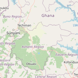
Map view of Bomfobiri Wildlife Sanctuary

Use this park location map to pinpoint Bomfobiri Wildlife Sanctuary in Ghana, understand its exact geographic position, and read its mapped placement within the surrounding landscape more clearly.

Pigeon | © OpenStreetMap contributors
Park atlas

Compare regional conservation landscapes and neighboring reserves in West Africa

Explore Protected Areas and Parks Near Bomfobiri Wildlife Sanctuary

Discover related protected areas and neighboring nature reserves situated within the wider regional geography surrounding Bomfobiri Wildlife Sanctuary. Extending the geographic review allows comparison of similar woodland and forest ecosystems across the surrounding territory.
Wildlife reserveAshanti Region
About 25 km away#1 closest

South

Bobiri Forest Reserve and Butterfly Sanctuary: Mapped Wildlife Reserve and Forest Geography

Ashanti Region protected landscape and butterfly habitat

Focusing on its status as a dedicated butterfly sanctuary, this protected forest reserve in Ghana offers a clear window into semi-deciduous ecology. Covering 54 square kilometers, the site is recognized for high insect biodiversity and its unique position as both an active research area and a managed wildlife reserve near the village of Kubease.

Area
54.65 km²
Established
1939
Relief
Upland
Climate
Tropical
Wildlife reserveBono East Region
About 102 km away#2 closest

Northwest

Boabeng-Fiema Monkey Sanctuary: Geographic Boundaries and Wildlife Reserve Context

Community-protected forest landscapes in Ghana

Boabeng-Fiema Monkey Sanctuary represents a rare community-based wildlife reserve located in central Ghana. Spanning 4.4 square kilometers between the villages of Boabeng and Fiema, the forest provides essential habitat for primate populations protected by generations of cultural tradition. This detail page offers geographic context, map exploration of the forest reserve, and insight into the unique intersection of woodland ecosystems and community-enforced conservation in the Bono East Region.

Area
4.4 km²
Established
1970
Relief
Lowland
Climate
Tropical
National parkBono East Region
About 124 km away#3 closest

Northeast

Digya National Park: Ghana's Oldest National Park, Bordering Lake Volta

Explore its unique geography and mapped protected boundaries.

Digya National Park is a significant protected area in Ghana, renowned as the nation's oldest, established in 1900 and gazetted as a national park in 1971. Occupying 3,743 square kilometers in the Bono East Region, it is distinctively bordered on three sides by the vast Lake Volta, creating an unparalleled terrestrial-aquatic habitat interface. This national park represents a key point in Ghana's geographic atlas, situated in a transitional zone between forest and savanna ecosystems, and is a vital hub for wildlife conservation and the study of its unique landscape character.

Area
3,743 km²
Established
1971
IUCN
II
Relief
Lowland
National parkGhana
About 137 km away#4 closest

South

Kakum National Park: Ghana's Landmark Protected Rainforest and Canopy Walkway

Mapped tropical forest landscape and unique elevated park exploration.

Kakum National Park represents a significant protected area within Ghana, characterized by its 375 square kilometers of moist evergreen tropical rainforest. The park's identity is strongly linked to its iconic canopy walkway, an engineering feat offering elevated views into the forest structure. As a national park, Kakum provides crucial mapped context for understanding West African biodiversity and regional geography, including notable primate populations and the densest concentration of forest elephants in Ghana. Its community-driven establishment also marks it as a key site for participatory conservation examples.

Area
375 km²
Established
1992
IUCN
II
Visitors
135.9K annual
Wildlife reserveCentral Region
About 174 km away#5 closest

South

Muni-Pomadze Ramsar Site: Protected Coastal Wetlands and Forest Reserves in Ghana

Coastal lagoons, mangrove stands, and undulating hill geography

Covering a compressed sequence of coastal and inland landforms, the Muni-Pomadze Ramsar Site serves as a significant protected landscape. This area encompasses the Muni Lagoon, shoreline dunes, and the forested slopes of the Yenku and Egyasimanku Hills, creating an ecologically diverse habitat that defines the geography of the surrounding coastline.

Area
3 km²
Established
1992
IUCN
II
A horizontal watercolor painting showing a winding river flowing through a lush marshy landscape with distant hills in the background.
Nature reserveGreater Accra Region
About 181 km away#6 closest

Southeast

Densu Delta Ramsar Site: Coastal Wetland Geography in the Greater Accra Region

Protected nature reserve, lagoon network, and tidal marshland

Located at the mouth of the Densu River, this Ramsar site features an interconnected system of mangroves, salt pans, and shallow lagoons. The protected area serves as an essential coastal buffer and bird habitat, showcasing the complex interplay between riverine freshwater and the marine environment of the Gulf of Guinea.

Area
58.93 km²
Established
1992
Water
Water-dominated
Protected landscapeWestern Region
About 183 km away#7 closest

Southwest

Mamiri Forest Reserve: Mapped Geography and Protected Landscape Identity in Western Ghana

Ecological transition zone of the Upper Guinea forest block

Spanning roughly 45 square kilometers, Mamiri Forest Reserve is defined by its unusual, elongated geometry and dissected hill-and-valley topography. This protected landscape serves as a vital transition zone between wet and moist evergreen forest types, supporting a complex array of seasonal wetland patches and upland forest ridges. Recognized for its significance as an Important Bird Area, it remains a critical remnant of the original high forest system found in this part of Ghana.

Area
45 km²
Established
1949
IUCN
V
Relief
Upland
Wildlife reserveVolta Region
About 185 km away#8 closest

East

Tafi Atome Monkey Sanctuary: Mapping Ghana's Community Protected Wildlife Reserves

Protected sacred grove geography in the Volta Region

Tafi Atome Monkey Sanctuary preserves a unique tropical forest ecosystem that has been protected by local tradition for over two centuries. Located in the Volta Region of Ghana, this wildlife reserve demonstrates the significance of community-based conservation. View the sanctuary through the lens of its forest structure, primate populations, and the surrounding rural mosaic that makes this site a key element of the region's protected landscape.

Established
1993
Relief
Lowland
Climate
Tropical
Access
Access unknown

Common questions about visiting, size, designation, and location context for Bomfobiri Wildlife Sanctuary

Bomfobiri Wildlife Sanctuary FAQs for park facts, access, geography, and protected area context

Find quick answers about Bomfobiri Wildlife Sanctuary, including protected-area facts, park geography, trail and visitor context, and how the park fits into its surrounding country and regional landscape.
MoriAtlas Explorer

Continue Your Protected Areas Search Across the Global Atlas

Deepen your exploration by continuing the structured search for national parks and protected areas worldwide. Utilize the comprehensive filtering capabilities to compare different conservation landscapes and refine your understanding of global park geography. Discover more about the distribution and characteristics of protected natural areas.

Global natural geography