Mori Atlas logo
Wildlife reserveBorakalalo Game Reserve

Tracing the bushveld terrain and aquatic habitats surrounding Klipvoor Dam and the Moretele River

Borakalalo Game Reserve: A Protected Wildlife Landscape in the North West Province of South Africa

Borakalalo Game Reserve is a significant protected area situated in the North West Province, defined by a mosaic of woodland, bushveld, and riparian environments. Centered on the hydrology of the Klipvoor Dam and the Moretele River, the reserve offers a representative look at South African interior plateau geography. This location supports diverse mammal and bird populations within a landscape characterized by seasonal water availability and dense woodland patches.

bushveldSouth AfricaNorth West Provincebirding destinationwildlife reservewoodland

Borakalalo Game Reserve

Wildlife reserve

Park overview

Structured park overview, official facts, and landscape profile for Borakalalo Game Reserve

Borakalalo Game Reserve park facts, protected area profile, and essential visitor context

Review the core facts for Borakalalo Game Reserve, including designation, size, terrain, visitor scale, habitats, and operating context in one park-focused overview.

About Borakalalo Game Reserve

Borakalalo Game Reserve sits in the central part of South Africa's North West Province, a region characterized by mixed bushveld landscapes, seasonal drainage systems, and scattered dams. The reserve is positioned within the Moretele Local Municipality, placing it close enough to the Pretoria, Johannesburg, and Brits region to serve as a convenient inland getaway, while still being far enough from major urban centers to retain a sense of open bushveld country. At roughly 130 square kilometers in size, the reserve is substantial enough to support a wide range of habitat types and a meaningful mammal population, yet compact enough to be explored over a single visit.

The defining physical anchor of the reserve is Klipvoor Dam and the Moretele River, which together create a network of water-associated habitats including open water, fringing wetland vegetation, and riverside woodland. Surrounding these water features is a matrix of bushveld vegetation, ranging from denser woodland patches to more open grassy areas. This combination of water, woodland, and bushveld is what gives Borakalalo much of its ecological character and is also what draws the diversity of wildlife that the reserve supports.

Borakalalo is widely regarded for its birdlife, with more than 350 recorded species underscoring its importance as a birding destination in this part of South Africa. The reserve is associated with several sought-after species, including African Finfoot along quiet river sections, Meyer's Parrot in woodland areas, and Grey-Headed Kingfisher along the reserve's wooded edges. Raptors and other birds of prey are also part of the broader birding attraction of the park.

The mammal community at Borakalalo mirrors the reserve's bushveld setting. Visitors may encounter common plains antelope such as impala, blesbok, blue wildebeest, red hartebeest, and waterbuck alongside less common species such as tsessebe, roan antelope, and sable antelope. Larger and more iconic mammals include giraffe, Cape buffalo, hippopotamus, and predators such as leopard, caracal, aardwolf, brown hyena, and black-backed jackal. Warthog and zebra round out a mammal list that gives the reserve a representative cross-section of South African bushveld fauna.

The reserve has also become widely identified with ongoing safety concerns, particularly for overnight stays, which have shaped how visitors engage with the park. Despite these challenges, Borakalalo's mix of birding opportunities, typical bushveld scenery, fishing prospects on Klipvoor Dam, and proximity to major South African urban centers keep it relevant as a protected area in the North West Province.

Quick facts and research context for Borakalalo Game Reserve

Borakalalo Game Reserve is a medium-sized protected area covering approximately 130 square kilometers in the North West Province of South Africa. It lies within the Moretele Local Municipality, north of the town of Brits and north-northwest of Pretoria. The reserve is anchored by the Klipvoor Dam and the Moretele River, with woodland and open bushveld forming the dominant vegetation. The area is recognized for hosting more than 350 bird species and a diverse mammal community.

Protection and recognition

Documented terrestrial protection scope and management records

Borakalalo Game Reserve Protection Status and International Recognition

Borakalalo Game Reserve maintains a documented terrestrial protection scope without imported international recognition sources. Protected area designation records outline the management framework governing regional conservation administration.

Protection details

Protection scope
Terrestrial
Transboundary protection
No
Park context

Deeper park guide and search-rich context for Borakalalo Game Reserve

Borakalalo Game Reserve history, landscape, wildlife, and travel context

Explore Borakalalo Game Reserve through its history, landscape character, ecosystems, wildlife, conservation priorities, cultural context, and seasonal travel timing in a structured park guide built for atlas discovery and search intent.

Why Borakalalo Game Reserve stands out

Borakalalo is especially known as a birding destination in the bushveld, supported by its position around Klipvoor Dam and the Moretele River. The combination of water-associated habitats and surrounding woodland attracts a wide variety of species, including sought-after sightings such as African Finfoot, Meyer's Parrot, and Grey-Headed Kingfisher. Beyond birds, the reserve is valued for its representative selection of bushveld mammal species, ranging from smaller antelope and predators to large grazers such as Cape buffalo and hippopotamus.
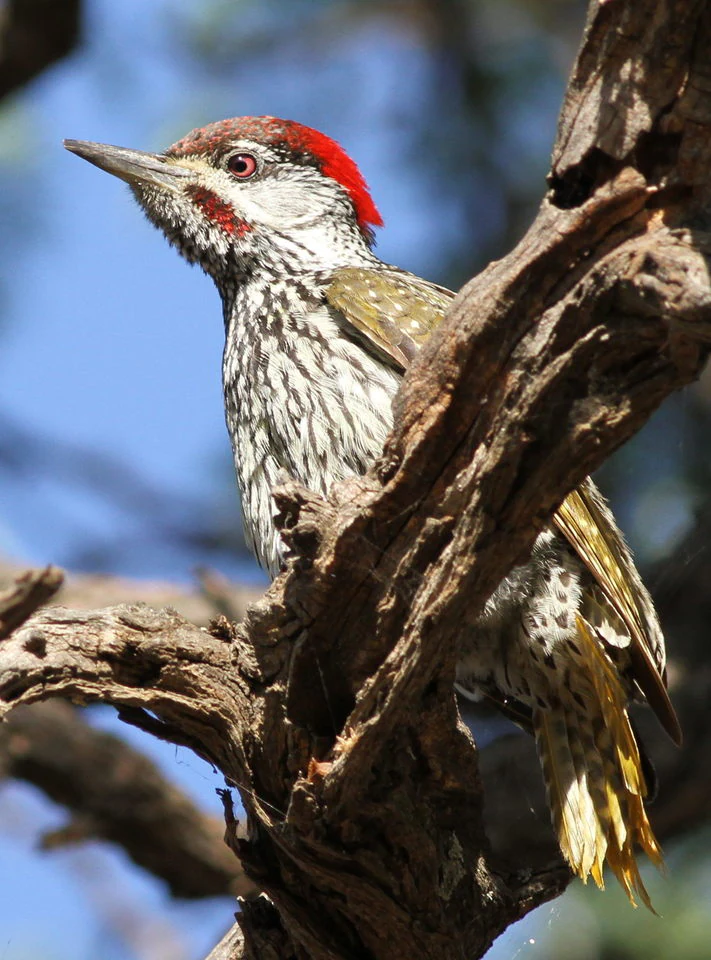
A male Golden-tailed Woodpecker with a red crown and spotted white and olive-green plumage perched on a gnarled tree branch.
A male Golden-tailed Woodpecker perched on a branch at Borakalalo Game Reserve.

Borakalalo Game Reserve landscape and geographic character

The physical setting of Borakalalo is defined by a mix of inland water features and surrounding bushveld terrain. The reserve is built around Klipvoor Dam, which serves as the main aquatic feature, with the Moretele River contributing additional water-associated habitats. These water features are framed by woodland patches and more open bushveld vegetation, producing a varied mosaic of riparian, wooded, and grassy landscapes.

The bushveld character of the reserve places it firmly within the broader South African interior plateau landscape. Open grassy clearings alternate with denser bushveld woodland, while the river and dam corridors introduce fringing vegetation and seasonal wetland edges. This combination creates the kind of layered scenery typical of North West Province reserves, where small changes in water availability and tree cover produce visible shifts in the surrounding terrain. Klipvoor Dam also offers a setting for fishing activity, adding an additional human interaction with the reserve's water landscape.
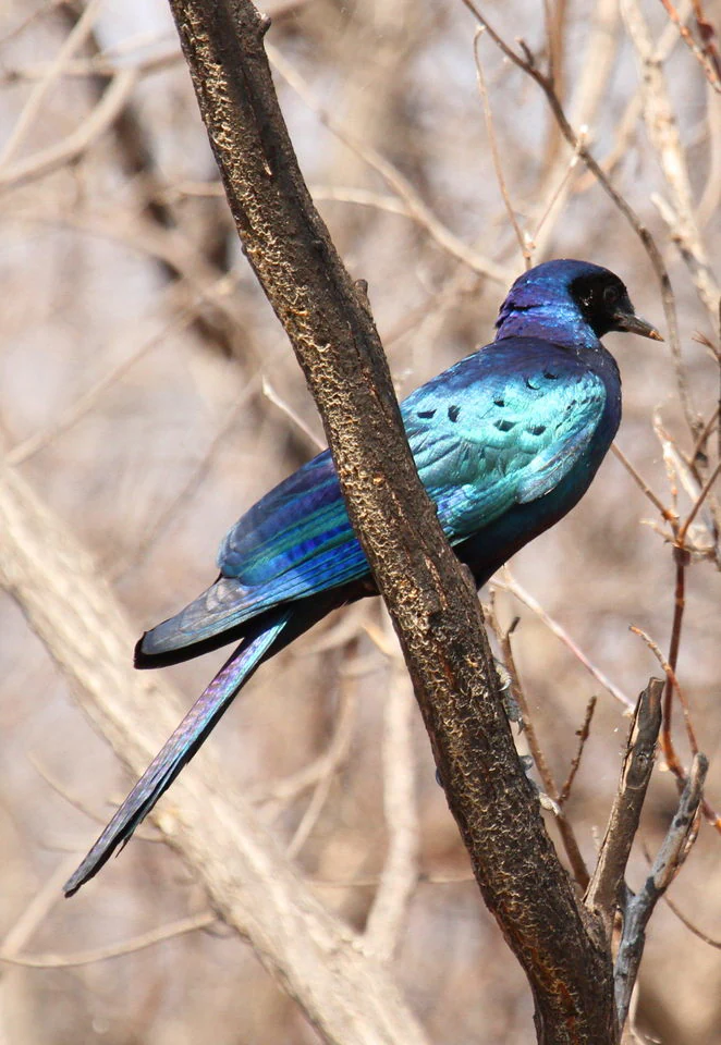
A side profile of a glossy iridescent Burchell's Starling perched on a dry tree branch.
A Burchell's Starling perched on a branch in Borakalalo Game Reserve.

Borakalalo Game Reserve ecosystems, habitats, and plant life

Borakalalo's ecological identity is rooted in the bushveld biome, particularly the mix of woodland and open bushveld that characterizes the North West Province. The presence of Klipvoor Dam and the Moretele River adds a substantial aquatic element, supporting fringing wetland vegetation, riparian zones, and habitat transitions between water, woodland, and open grass areas. These varied environments together support both resident and seasonal wildlife.

The habitat mix at Borakalalo favors species that depend on cover, water margins, and open browsing or grazing areas. Water-associated mammals and birds benefit directly from the dam and river system, while woodland dwellers flourish in the surrounding bushveld. The result is a reserve with several overlapping ecological niches layered across a relatively compact area, which contributes to the diversity of life observed across the park.

Borakalalo Game Reserve wildlife and species highlights

Borakalalo Game Reserve supports a wide cross-section of South African bushveld fauna. Among antelope, the reserve hosts common plains species such as impala, blesbok, blue wildebeest, red hartebeest, waterbuck, common reedbuck, and mountain reedbuck, alongside less frequently encountered varieties including eland, gemsbok, nyala, tsessebe, roan antelope, and sable antelope. Warthog and zebra are also present, completing a representative selection of bushveld grazers and browsers.

Larger mammals at Borakalalo include giraffe, hippopotamus in the dam and river areas, and Cape buffalo among the reserve's more substantial species. The predator presence is also notable for a reserve of this size. Records include leopard, caracal, brown hyena, aardwolf, black-backed jackal, and Cape fox, giving Borakalalo a meaningful carnivore profile alongside its herbivore communities.

The birdlife at Borakalalo is one of its strongest wildlife features, with more than 350 recorded species. The reserve hosts a range of raptors and other birds of prey, and is particularly valued among birdwatchers for special sightings such as African Finfoot in quieter water sections, Meyer's Parrot in woodland areas, and Grey-Headed Kingfisher in suitably wooded edges. Other notable species documented through bird photographs taken in the reserve include Burchell's starling and Golden-tailed woodpecker, suggesting additional richness across common and more localized woodland bird groups.

Borakalalo Game Reserve conservation status and protection priorities

Borakalalo Game Reserve is a formally protected area in the North West Province, conserving a representative sample of bushveld habitat together with the water-associated ecosystems around Klipvoor Dam and the Moretele River. Its conservation value lies in maintaining a mosaic of woodland, open bushveld, and aquatic habitat in a region where land-use pressure from surrounding settlements and infrastructure continues to shape the landscape.

By sustaining populations of both widespread and more range-restricted antelope species, larger mammals such as hippopotamus, giraffe, and Cape buffalo, and a wide variety of birdlife, the reserve contributes to regional biodiversity persistence in the North West Province. However, the reserve has been affected by ongoing safety issues, which have impacted visitor experiences and raised concerns about long-term management and public engagement.

Top sights and standout views in Borakalalo Game Reserve

Borakalalo Game Reserve stands out for combining bushveld landscape, water-based habitat around Klipvoor Dam and the Moretele River, and one of the stronger bird lists in the North West Province, with more than 350 recorded species. The reserve offers a representative cross-section of South African bushveld mammals, from common antelope to less frequent species such as roan antelope, sable antelope, and tsessebe, alongside larger mammals like giraffe, hippopotamus, and Cape buffalo, and predators including leopard and brown hyena.

Best time to visit Borakalalo Game Reserve

Borakalalo's character shifts with the wet and dry seasons typical of the South African bushveld. Visiting during the wetter summer months often brings greener landscapes, more active birdlife, and fuller water conditions around Klipvoor Dam and the Moretele River, which can be advantageous for birdwatching and general game viewing. The drier winter months may concentrate wildlife around remaining water sources, while also offering cooler conditions and clearer visibility in the more open bushveld areas. As with many reserves in the region, visitors considering overnight stays should be aware of the safety concerns reported in connection with the reserve.
Monthly climate preview

Long-term monthly temperature and precipitation data for Borakalalo Game Reserve

Borakalalo Game Reserve Climate Normals and Measured Temperature Patterns

Historical averages for Borakalalo Game Reserve reveal a measured annual temperature and precipitation rhythm across all twelve months. Examining the complete monthly profile provides deeper insight into long-term climate variations at a representative coordinate.
Annual mean20 °C
13 °C25 °C
Jan25°
Feb24°
Mar23°
Apr20°
May16°
Jun13°
Jul13°
Aug16°
Sep21°
Oct23°
Nov24°
Dec25°
Warmest month
January

24.7 °C

Coolest month
July

12.9 °C

Wettest month
January

3.2 mm/day

Driest month
July

0 mm/day

Park location guide

Geography guide, regional context, and park location map for Borakalalo Game Reserve

Borakalalo Game Reserve park geography, regions, and map view in South Africa

Understand where Borakalalo Game Reserve sits in South Africa through a broader geographic reading of the surrounding landscape, nearby location context, and its mapped position within the national park landscape.

How Borakalalo Game Reserve fits into South Africa

South Africa is the southernmost country in Africa, spanning 1.22 million km² with a population of over 63 million. The country operates with three capital cities, Pretoria (executive), Cape Town (legislative), and Bloemfontein (judicial), and is renowned for its biodiversity, national parks, and multicultural society.

Wider geography shaping Borakalalo Game Reserve in South Africa

South Africa occupies the southernmost region of Africa, with coastline along both the Atlantic Ocean to the west and the Indian Ocean to the east. The interior features elevated plateaus including the Highveld, with the Drakensberg escarpment marking the eastern highlands. The country shares borders with Namibia, Botswana, Zimbabwe, Mozambique, Eswatini, and Lesotho.

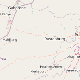
Map view of Borakalalo Game Reserve

Use this park location map to pinpoint Borakalalo Game Reserve in South Africa, understand its exact geographic position, and read its mapped placement within the surrounding landscape more clearly.

Pigeon | © OpenStreetMap contributors

Location context for Borakalalo Game Reserve

North West Province

Visual reference collection highlighting woodland habitats, river corridors, and protected terrain.

Borakalalo Game Reserve Landscape Photos and Bushveld Scenery Views

Visual records capture the distinctive bushveld terrain, woodland patches, and open wetland edges defining Borakalalo Game Reserve. Photographic documentation offers a clear look at the interior plateau landscape, Klipvoor Dam waters, and surrounding wildlife habitats.

A male Golden-tailed Woodpecker with a red crown and spotted white and olive-green plumage perched on a gnarled tree branch.

A side profile of a glossy iridescent Burchell's Starling perched on a dry tree branch.

Park atlas

Compare adjacent bushveld terrain, regional reserves, and woodland habitats

Parks Near Borakalalo Game Reserve and Surrounding Protected Areas

Browse other parks near Borakalalo Game Reserve to examine similar bushveld terrain, inland watercourses, and regional wildlife populations. Comparing adjacent protected areas reveals broader ecological patterns across the South African interior plateau landscape.
Nature reserveLimpopo
About 43 km away#1 closest

Northeast

Mabalingwe Nature Reserve: Protected Bushveld Geography and Terrain Analysis

Mapping the Limpopo reserve landscape and habitat features

Examine the 8,800-hectare landscape of Mabalingwe Nature Reserve. From its malaria-free bushveld habitat to its network of seasonal dams and mixed woodland terrain, this entry provides a clear look at the environmental context of this private Limpopo protected area.

Area
88 km²
Established
1989
Relief
Upland
Climate
Subtropical
Wildlife reserveLimpopo
About 49 km away#2 closest

North

Mabula Game Reserve: Protected Bushveld and Geographic Landscape Profile

Exploration of the Limpopo bushveld and wildlife habitat boundaries

Mabula Game Reserve provides a detailed look at the bushveld ecosystems of South Africa. Spanning 12,000 hectares in Limpopo, the reserve features a unique blend of rocky ridges, open savanna, and riverine woodlands. Its structural diversity creates a distinct natural corridor that serves as a focal point for understanding regional wildlife distribution and the transition zone between the Waterberg and the northern plains.

Area
120 km²
Scope
Terrestrial
Biosphere reserveLimpopo
About 74 km away#3 closest

North

Waterberg Biosphere: A Protected Sandstone Massif in Limpopo Province South Africa

Geology, mapping, and ecological zones of the Waterberg range

The Waterberg Biosphere stands as a major protected region in South Africa, formed by ancient sandstone layers sculpted into mesas and deep gorges. This massif bridges ecological zones from highland savanna to riverine habitats, anchoring a network of game reserves and wilderness areas through its distinctive geological and historical landscape identity.

Area
6,540.33 km²
Established
2001
Relief
Mountain
Climate
Subtropical
National parkLimpopo Province
About 74 km away#4 closest

North

Marakele National Park: National Park Protected Landscape and Geographic Context

Explore its Limpopo Province regional setting and mapped boundaries.

Marakele National Park represents a vital protected national park within the diverse geography of Limpopo Province, South Africa. This entry provides detailed atlas-style information on its protected landscape, focusing on mapped geographic boundaries and its context within the regional natural terrain. It serves as a key resource for understanding the park's specific role as a conservation area and its place within the broader atlas of South African protected lands.

Area
670 km²
Established
1994
Relief
Mountain
Climate
Subtropical
A pale, minimalist watercolor painting depicting rolling green hills in the distance with a winding dirt path leading through grassy plains in the foreground.
National parkNorth West Province
About 75 km away#5 closest

West

Pilanesberg National Park: Geologic Mapping of a South African Alkaline Ring Complex

Explore concentric volcanic terrain and protected bushveld landscapes

Pilanesberg National Park covers the eroded root of a massive 1.2 billion year old volcano. Its defining feature is a series of concentric hills and basins that rise from the flat bushveld plains of South Africa. This protected area offers a distinct geographic study in volcanic topography, featuring rocky syenite outcrops, open savanna, and varied water sources that define the ecological character of this significant regional landscape.

Area
572 km²
Established
1984
Relief
Mountain
Climate
Subtropical
A watercolor illustration of rolling green hills, distant mountains, and a pale sky.
Protected landscapeNorth West
About 75 km away#6 closest

South

Magaliesberg Protected Natural Environment: Mapped Geography and Protected Landscape Context

Ancient mountain ridges between Rustenburg and Pretoria

Spanning a long quartzite ribbon, the Magaliesberg Protected Natural Environment represents a sophisticated model of private land conservation. The geography reveals a dramatic elevation gradient where Highveld plateaus meet lower-lying bushveld terrain. This atlas entry details the protected boundaries and the integrated landscape connection between surrounding nature reserves.

Area
343.56 km²
Established
1994
Relief
Mountain
Scope
Terrestrial
Watercolor painting of a river flowing through a hilly, green valley with rocky cliffs on the right.
Biosphere reserveNorth West
About 77 km away#7 closest

South

Magaliesberg Biosphere Reserve: Geographic Overview and Protected Area Landscape Mapping

Ancient mountain ranges in South Africa

The Magaliesberg Biosphere Reserve features a rugged terrain of high ridges and deep kloofs that support a vast array of bird species and vegetation. As a significant conservation area in North West, it preserves geological history alongside critical transitional ecosystems. Discover the mapped boundaries and natural features of this protected region that bridges urban centers and wilderness.

Area
3,578.7 km²
Established
2015
Relief
Mountain
Climate
Subtropical
A soft watercolor illustration depicting rolling green hills and subtle landscape features on a white background.
Nature reserveGauteng
About 79 km away#8 closest

Southeast

Klapperkop Nature Reserve: Mapping Protected Bankenveld and Highveld Landscapes

A vital protected nature reserve in Gauteng, South Africa

Klapperkop Nature Reserve protects a representative segment of threatened highveld bankenveld grassland near Pretoria. The reserve features the distinct Klapperkop hill, historic fortifications, and restored savanna ecosystems that offer a window into the natural heritage of the Gauteng region.

Area
4.6 km²
Established
1898
Relief
Upland
Climate
Subtropical

Common questions about visiting, size, designation, and location context for Borakalalo Game Reserve

Borakalalo Game Reserve FAQs for park facts, access, geography, and protected area context

Find quick answers about Borakalalo Game Reserve, including protected-area facts, park geography, trail and visitor context, and how the park fits into its surrounding country and regional landscape.
MoriAtlas Explorer

Continue Your Protected Areas Search Across the Global Atlas

Deepen your exploration by continuing the structured search for national parks and protected areas worldwide. Utilize the comprehensive filtering capabilities to compare different conservation landscapes and refine your understanding of global park geography. Discover more about the distribution and characteristics of protected natural areas.

Global natural geography