

Mori Atlas logo
Nature reserveBorkener See

A reclaimed mining landscape serving as a critical migratory bird sanctuary and oligotrophic lake habitat.

Borkener See Nature Reserve and Protected Wetland Landscapes in the Schwalm-Eder-Kreis Region

(Naturschutzgebiet Borkener See)

Borkener See represents a significant transformation of former lignite mining terrain into a protected nature reserve in northern Hesse. Situated within the Schwalmaue corridor, the lake supports unique alkaline, low-nutrient water chemistry and serves as an internationally recognized staging area for migratory waterfowl. The site maps the intersection of industrial reclamation and high-value ecological restoration.

lakenature reserveformer mining siteoligotrophic lakemigratory birdsbirdwatching

Borkener See

Nature reserve

Park overview

Structured park overview, official facts, and landscape profile for Borkener See

Borkener See park facts, protected area profile, and essential visitor context

Review the core facts for Borkener See, including designation, size, terrain, visitor scale, habitats, and operating context in one park-focused overview.

About Borkener See

Borkener See is a relatively young lake whose existence traces directly back to industrial extraction. The open-cast lignite mine known as Grube Altenburg IV operated from 1954 to 1975, removing roughly 70 million cubic meters of overburden to extract approximately 9 million tons of coal. Once mining ended, the residual pit began filling with groundwater seeping up through the layered Buntsandstein formations beneath it, a slow process that, combined with deliberate reclamation choices, shaped the lake that exists today.

Early in the reclamation period, ideas surfaced to accelerate filling and convert the site into a recreational area with weekend cabins. Water quality testing soon revealed that the lake was both slightly alkaline and oligotrophic, conditions that discouraged intensive recreational development and instead pointed toward conservation use. From 1975 to 1992 the lake gradually took shape, and in 1990 its shorelines and waters were formally designated a nature reserve, effectively locking in a different future than the one first imagined.

The protected area around Borkener See now covers roughly 350 hectares and includes not only the lake but also a deliberately created wetland biotope in the north of the former mining zone and a so-called "dramatic landscape" in the south-east, an unstable area of repeated subsidence and slope failure where flora and fauna continually adapt to shifting ground. A roughly 7.3-kilometer circular walking path with several observation hides allows visitors to experience the site without disturbing its wildlife. Swimming, fishing, and other water-based recreation are prohibited throughout the reserve.

Quick facts and research context for Borkener See

Borkener See is a former lignite mining lake located in the Schwalm-Eder district of northern Hesse, at roughly 177 meters above sea level. It occupies part of the Westhessische Senke, within the floodplain of the Schwalm river system near the town of Borken.

The lake covers approximately 139 hectares, reaches a maximum depth of about 52 meters, and is fed by stratified springs from the Buntsandstein bedrock. Its waters are nutrient-poor (oligotrophic) and slightly alkaline, an unusual combination for a lake of its size in Hesse. The surrounding catchment of some 350 hectares has been protected as a nature reserve since 1990, with broader European protections following in subsequent decades.

Protection and recognition

Documented terrestrial protection history and Natura 2000 recognition records

Borkener See Protection Status and International Recognition Data

Borkener See features established terrestrial protection history dating from 1990 alongside verified Natura 2000 designation records. Structured preservation facts outline the documented management scope and official recognition sources associated with the protected landscape.

International recognition

Protection details

Protection scope
Terrestrial
Designated year
1990
Transboundary protection
No
Park context

Deeper park guide and search-rich context for Borkener See

Borkener See history, landscape, wildlife, and travel context

Explore Borkener See through its history, landscape character, ecosystems, wildlife, conservation priorities, cultural context, and seasonal travel timing in a structured park guide built for atlas discovery and search intent.

Why Borkener See stands out

Borkener See is best known as a major migratory bird staging site in central Germany, set within a former open-cast lignite mining landscape that has been deliberately reclaimed for conservation. Its large, deep, oligotrophic waters host waterfowl, waders, and terns during migration, while the surrounding reclaimed terrain provides additional habitats for wetland and pioneer species. The lake also stands out for its combination of unusual water chemistry, a slightly alkaline pH paired with low nutrient levels, and a protected status that layers national nature reserve, FFH, and EU Birds Directive designations over a single site. This stacking of protective categories reflects its recognized ecological significance at both regional and European scales.
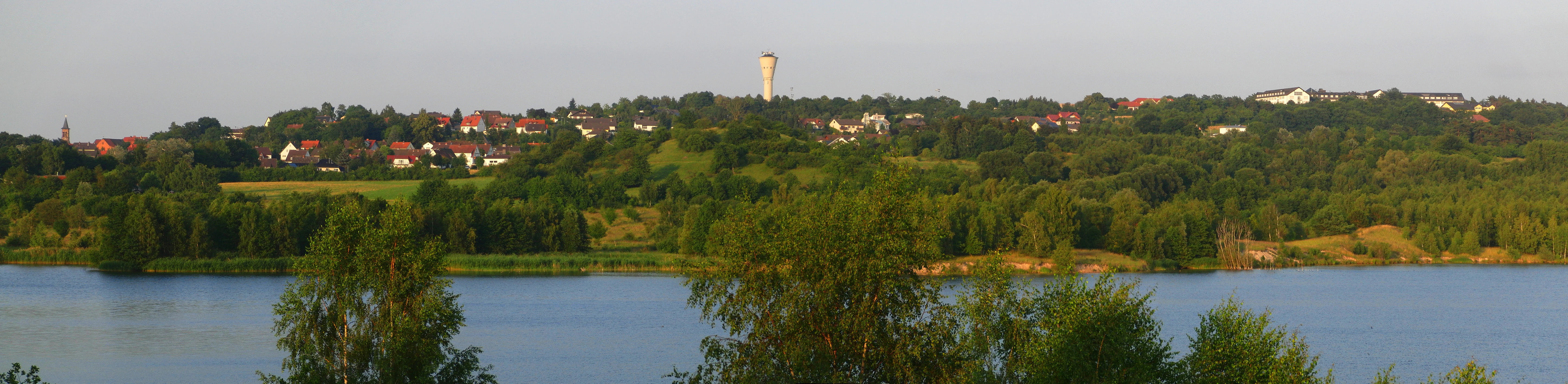
Panorama of Borkener See
Panoramic view of Borken from the shore of Borkener See

Borkener See history and protected-area timeline

The history of Borkener See is inseparable from the history of coal mining in the Borkener Braunkohlerevier. Between 1954 and 1975, the open-cast mine Grube Altenburg IV transformed the landscape southwest of Borken, displacing enormous volumes of overburden to access lignite seams beneath the lowlands of the Westhessische Senke.

When the mine closed, the residual pit entered a long reclamation phase that lasted from 1975 to 1992. Initial plans leaned toward accelerated filling and conversion of the resulting lake into a leisure area, but ecological surveys revealed a slightly alkaline, nutrient-poor body of water that was better suited to conservation than to recreation. This shift in approach led directly to formal protection: in 1990 the lake and its shores were declared a nature reserve.

The site has since accumulated additional layers of recognition. In 2000 it was designated an FFH area under the EU Habitats Directive, and in 2008 it was added to the network of EU Birds Directive sites. The purchase of surrounding land by the Stiftung Hessischer Naturschutz, jointly with the federal government, was a key step in shielding the catchment from agricultural nutrient inputs that would otherwise have pushed the lake toward eutrophication.

Borkener See landscape and geographic character

The lake sits in the Schwalmaue, a low-lying section of the Westhessische Senke characterized by gentle topography and historically wet, alluvial ground. Surrounding terrain is shaped both by natural floodplain processes and by the legacy of deep lignite mining, which left behind steep pit edges, subsided ground, and occasionally unstable slopes.

The shoreline itself is irregular and partially bordered by the urban edge of Borken and the villages of Nassenerfurth and Trockenerfurth. In the south-east, a designated "dramatic landscape" area preserves terrain marked by ongoing subsidence and slope slips, producing a raw, changeable environment uncommon in this otherwise subdued region. To the north, a purpose-built wetland biotope adds shallow-water and marsh habitat to the landscape, contrasting with the deep, open water of the main lake.
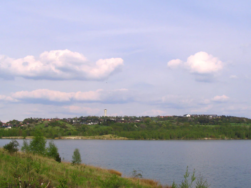
Borkener See
View over Borkener See toward the town of Borken

Borkener See ecosystems, habitats, and plant life

Borkener See is ecologically distinctive because it pairs deep, open water with a protected catchment that buffers the system against agricultural runoff. The lake is oligotrophic and slightly alkaline, a combination that differentiates it from many other sizable lakes in Hesse and supports communities of plants and animals adapted to these specific conditions.

Around the lake, habitats range from open water to reed-lined shore, marshy wetland, and the disturbance-driven pioneer habitats of the unstable southern sector. The northern wetland biotope, with its deliberately extended shoreline relative to water area, increases habitat diversity at the margins. Together these zones provide a mosaic of resting and feeding environments for waterbirds and a range of other species responding to the lake's unusual chemistry and protected setting.
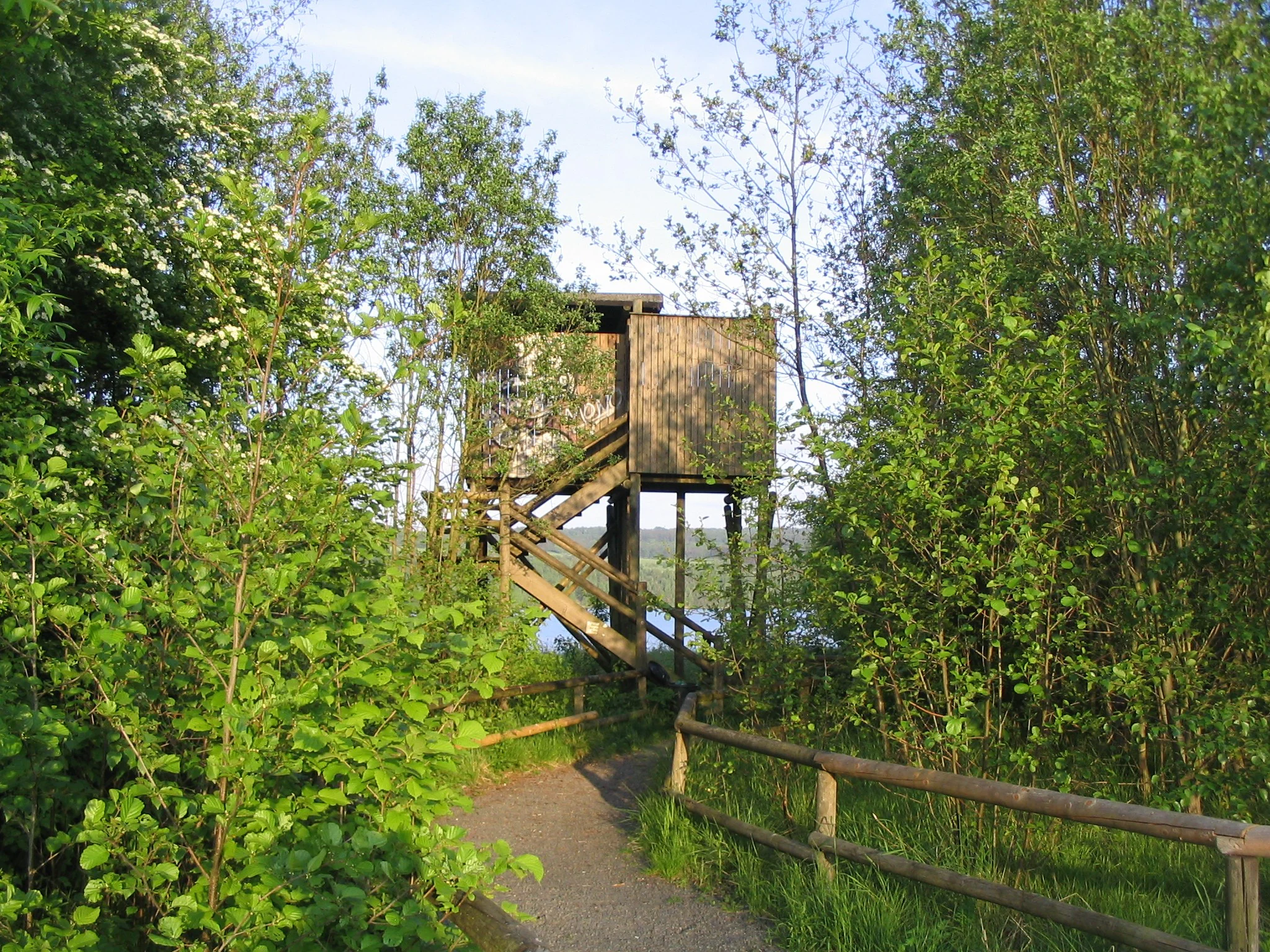
Hunting stand at Borkener See
A raised hunting blind overlooking the Borkener See area.

Borkener See wildlife and species highlights

The lake's wildlife significance is dominated by birds. It functions as an important staging and resting area for migratory waterfowl, waders, and terns, with species such as the common scoter (Trauerente) and the black tern (Trauerseeschwalbe) documented among the visitors the site supports.

Beyond migratory visitors, the reserve's mosaic of open water, marsh, and disturbed pioneer terrain supports resident and breeding birdlife typical of large protected lakes in central Germany. The deliberate prohibition of water-based recreation keeps disturbance low, which has been a key factor in maintaining the site's ornithological value at a regional and European level.

Borkener See conservation status and protection priorities

Borkener See exemplifies how a post-industrial landscape can be redirected toward long-term conservation. The decision not to accelerate filling and convert the lake for leisure use, taken once its oligotrophic, slightly alkaline character became clear, set the course for decades of subsequent protection.

The stacking of designations reflects the site's recognized value: a national nature reserve since 1990, an FFH area since 2000, and an EU Birds Directive site since 2008. The acquisition of the surrounding agricultural land by the Stiftung Hessischer Naturschutz, jointly with the federal government, was central to keeping nutrient inputs low and preserving the lake's oligotrophic state. These measures collectively prevent swimming, fishing, and motorized water sports, keeping disturbance to a minimum and sustaining the conditions that make the lake ecologically significant.

Borkener See cultural meaning and human context

The cultural context of Borkener See is closely tied to the industrial and mining heritage of northern Hesse. For two decades the land above the lake was an active lignite surface mine, and the contemporary landscape carries visible traces of that extraction era, from steep pit edges to subsided ground in the "dramatic landscape" sector.

The town's renewed relationship with the site, as a protected natural area encircled by a walking path and observation hides, reflects a broader shift in regional identity from industrial extraction toward conservation and low-impact outdoor recreation. Local publications, including the city's anniversary volumes, have documented this transition as part of Borken's modern history.

Top sights and standout views in Borkener See

Borkener See is a former lignite mine transformed into a protected lake, now recognized at European level for its value to migratory waterbirds. Its oligotrophic, slightly alkaline waters set it apart ecologically from most larger lakes in Hesse.

A roughly 350-hectare protected zone surrounds the water, combining national nature reserve, FFH, and EU Birds Directive status. A 7.3-kilometer circular path with observation hides offers quiet, low-impact access to one of the more distinctive reclaimed landscapes in the Westhessische Senke.

Best time to visit Borkener See

The lake's character shifts with the seasons in ways that matter most for birdwatchers. Spring and autumn migration periods are typically the most rewarding times to visit, when waterfowl, waders, and terns use the lake as a staging and resting site, and observation hides along the circular path are most active.

Summer offers long daylight hours and stable weather for walking the full 7.3-kilometer circuit, while winter can bring frosty, quiet conditions that emphasize the lake's open, undisturbed atmosphere. Because swimming, fishing, and water sports are prohibited throughout the reserve, visits at any time of year tend to be focused on walking, observation, and quiet enjoyment of the landscape rather than active recreation.

Monthly climate preview

Trace long-term average temperature and precipitation rhythms across the protected area.

Borkener See Climate Normals and Monthly Temperature Patterns

Representative coordinates record measured multi-year temperature variations alongside steady daily precipitation amounts throughout the year. Reviewing the complete monthly profile provides deeper context for long-term climate patterns across the landscape.
Annual mean9 °C
-1 °C19 °C
Jan-1°
Feb
Mar
Apr
May12°
Jun16°
Jul19°
Aug18°
Sep14°
Oct
Nov
Dec
Warmest month
July

18.6 °C

Coolest month
January

-0.8 °C

Wettest month
July

2.5 mm/day

Driest month
April

1.4 mm/day

Park location guide

Geography guide, regional context, and park location map for Borkener See

Borkener See park geography, regions, and map view in Germany

Understand where Borkener See sits in Germany through a broader geographic reading of the surrounding landscape, nearby location context, and its mapped position within the national park landscape.

How Borkener See fits into Germany

Germany is a federal republic in Western and Central Europe with a population of over 83 million across sixteen constituent states. It is Europe's largest economy by nominal GDP and a major global exporter and importer. The capital is Berlin, and the country borders Denmark, Poland, Czech Republic, Austria, Switzerland, France, Luxembourg, Belgium, and the Netherlands.

Wider geography shaping Borkener See in Germany

Germany is located in Western and Central Europe, spanning 357,022 km². It borders Denmark to the north, Poland and the Czech Republic to the east, Austria and Switzerland to the south, and France, Luxembourg, Belgium, and the Netherlands to the west. The country has coastlines on the Baltic Sea and North Sea to the north, with the Alps located in the southern region.

Map view of Borkener See

Use this park location map to pinpoint Borkener See in Germany, understand its exact geographic position, and read its mapped placement within the surrounding landscape more clearly.

Pigeon | © OpenStreetMap contributors

Location context for Borkener See

HesseSchwalm-Eder-Kreis
Recorded earthquake history

Review Recorded Seismic History and Earthquake Data Near Borkener See

Gain insight into regional seismic history through a curated collection of earthquake records associated with the Borkener See nature reserve. MoriAtlas makes it simple to examine historical event data, including magnitude and focal depth, to support your interest in the geological context of the Schwalm-Eder district.

Borkener See Earthquake History

Catalogued events

1 event

Strongest magnitude

Magnitude 3.4

Most recent event

Jan 29, 1982

This history includes earthquakes recorded inside the park or within 50 km of its borders

Visualizing the terrain, habitats, and protected environment of northern Hesse

Borkener See Photos and Landscape Scenery Visual Exploration

Visual documentation of Borkener See reveals the unique character of its reclaimed mining topography, open water, and wetland habitats. Examining these protected landscapes provides clear insight into the environmental features and bird staging areas that define the region.

Panorama of Borkener See

Borkener See circular path

Borkener See

Hunting stand at Borkener See

Park atlas

Compare regional protected areas and neighboring lowland conservation sites

Explore Parks Near Borkener See and Other Protected Landscapes

Browsing parks near Borkener See reveals connected wetland reserves and reclaimed habitats across the surrounding Hessian depression. Regional comparisons provide deeper insight into local hydrology, migratory bird staging zones, and protected lowland geography.
Nature reserveSchwalm-Eder-Kreis
9.1 km away#1 closest

East

Mosenberg bei Homberg Nature Reserve: Mapped Protected Landscape and Regional Geography

Nature reserve terrain in the Schwalm-Eder-Kreis district of northern Hesse

Spanning 64 hectares, Mosenberg bei Homberg preserves a diverse mixture of traditional agricultural landscapes including open grasslands and wood-pastures. The area provides a critical habitat for specialized birds, defined by its steep basalt scree and proximity to the Klingelbach stream. This site offers a clear example of how historic coppice woodland systems maintain significant biodiversity across the northern Hesse region.

Area
0.646 km²
Established
1986
Relief
Upland
Climate
Temperate
Nature reserveHesse
About 11 km away#2 closest

East

Eichelskopf Nature Reserve: Protected Geological and Historical Landscapes in Hesse

Regional conservation profile and mapped boundaries in Schwalm-Eder.

Examine the conservation history of Eichelskopf, a key nature reserve in the Schwalm-Eder district of Hesse. Established in 1927, this site remains a vital point of interest for understanding the evolution of species protection and geological heritage management in central Germany.

Area
0.027 km²
Established
1927
Scope
Terrestrial
Nature reserveSchwalm-Eder-Kreis
About 14 km away#3 closest

East

Goldbergsee Nature Reserve and Mapped Protected Landscapes in Schwalm-Eder-Kreis

Ecological transition and inland water-body geography.

Goldbergsee stands as a prime case study of industrial renaturalization in northern Hesse. This protected nature reserve, characterized by its clear spring-fed water and successional woodland habitat, offers a window into how former open-cast mining sites evolve into ecologically balanced water bodies within the Schwalm-Eder-Kreis mountain foothills.

Established
1991
Nature reserveHesse
15 km away#4 closest

East

Roßbachtal bei Völkershain Nature Reserve: Geography and Protected Valley Landscapes

Stream-fed meadow and forest habitats in Hesse

Located in the Schwalm-Eder-Kreis, Roßbachtal bei Völkershain encompasses a linear valley environment within the Knüllgebirge. The reserve tracks the Roßbach stream as it moves toward the Breitenbach, featuring a protected alignment of meadows and slopes that serves as a focused habitat management area in central Germany.

Area
1.141 km²
Established
1988
IUCN
IV
Nature reserveHesse
About 16 km away#5 closest

Southwest

Biedenbacher Teiche bei Florshain Nature Reserve, Hesse Protected Wetland Geography

A rare refuge of stream-fed ponds and meadows in northern Hesse

The Biedenbacher Teiche bei Florshain nature reserve protects a dense concentration of wetland microhabitats along the Biedenbach stream. Spanning ponds, sedge beds, and floodplain woodlands, this site offers a look into the vital ecological character of the Schwalm-Eder region. It remains an essential, undisturbed archive of local wetland flora and fauna within the larger, intensively cultivated Hessian agricultural landscape.

Area
0.035 km²
Established
1983
Relief
Lowland
Climate
Temperate
Protected landscapeHesse
About 16 km away#6 closest

Southeast

Naturpark Knüll: Geography, Basalt Formations, and Protected Areas of Northern Hesse

An expansive cultural landscape defined by volcanic ridges and riverine habitats

Naturpark Knüll offers a deep look into the geological and structural diversity of the Knüllgebirge. By mapping the transitions between bunter sandstone, basalt hilltops, and fertile floodplains, this resource highlights the region's role in biodiversity conservation and sustainable land management across the Schwalm-Eder and Hersfeld-Rotenburg districts.

Area
832.58 km²
Established
2021
Relief
Mountain
Climate
Temperate
Protected landscapeHessen
About 16 km away#7 closest

West

Naturpark Kellerwald-Edersee: Protected Landscape Geography and Map Context

Mapping the forest ridges and reservoir shores of northern Hessen

Examine the geographic foundation of Naturpark Kellerwald-Edersee, a sprawling protected area in northern Hessen. The landscape is characterized by its expansive ancient beech forests, deep valleys, and the Edersee reservoir. This entry provides a detailed look at the park's low mountain terrain, elevation ranges, and the ecological connectivity between its wooded ridges and surrounding river systems.

Area
595.25 km²
Established
2001
Relief
Mountain
Climate
Temperate
Protected landscapeHesse
About 17 km away#8 closest

North

Naturpark Habichtswald: Protected Landscape and Basalt Terrain Atlas in Northern Hesse

Exploration of forested ridges and medieval castle ruins.

Explore the geographic identity of Naturpark Habichtswald, a prominent protected landscape in northern Hesse. This record covers the park's volcanic basalt hills, broad wooded ridges, and the diverse historical ruins that define its unique topographic character across the Habichtswälder Bergland.

Area
474.28 km²
Established
1962
Relief
Mountain
Climate
Temperate

Common questions about visiting, size, designation, and location context for Borkener See

Borkener See FAQs for park facts, access, geography, and protected area context

Find quick answers about Borkener See, including protected-area facts, park geography, trail and visitor context, and how the park fits into its surrounding country and regional landscape.
MoriAtlas Explorer

Continue Your Protected Areas Search Across the Global Atlas

Deepen your exploration by continuing the structured search for national parks and protected areas worldwide. Utilize the comprehensive filtering capabilities to compare different conservation landscapes and refine your understanding of global park geography. Discover more about the distribution and characteristics of protected natural areas.

Global natural geography