Mori Atlas logo
Nature reserveBruchwald am Gahrenberg

Examining the hydrology, spring mires, and woodland mosaic in northern Hessen Germany

Bruchwald am Gahrenberg Nature Reserve: A Detailed Atlas of Protected Marsh Forest Landscapes

Bruchwald am Gahrenberg serves as a vital protected area in the southern Reinhardswald region of Germany. This nature reserve preserves a distinct complex of spring-fed marsh forests and bog woodland communities that anchor the headwaters of regional Fulda river tributaries. Map exploration reveals a landscape defined by saturated terrain, small impoundment ponds, and scattered grassland patches that function as an integral part of the broader forest ecosystem.

wet woodlandmarsh forestbog woodlandspring miresNatura 2000FFH site

Bruchwald am Gahrenberg

Nature reserve

Park overview

Structured park overview, official facts, and landscape profile for Bruchwald am Gahrenberg

Bruchwald am Gahrenberg park facts, protected area profile, and essential visitor context

Review the core facts for Bruchwald am Gahrenberg, including designation, size, terrain, visitor scale, habitats, and operating context in one park-focused overview.

About Bruchwald am Gahrenberg

Bruchwald am Gahrenberg is a compact but ecologically distinctive nature reserve located in the federal state of Hesse, in central Germany. It lies in the Landkreis Kassel, northeast of the city of Kassel, within the unincorporated communal area of Gutsbezirk Reinhardswald. The reserve is part of the larger Naturpark Reinhardswald, one of the notable low mountain range forest landscapes of northern Hesse, and sits at the southern fringe of the Reinhardswald forest massif in the area around the Sandkopf elevation.

Covering roughly 41 hectares and made up of two separate parcels (Teilflächen), the protected area is dedicated to conserving the wet woodland communities that develop where groundwater and surface seepage produce permanently moist conditions. The forest types protected here include classic Bruchwald, or marsh forest, as well as Moorwald, bog woodland, with gradual transitions into the surrounding Rotbuchenwald, beech forest, that dominates much of the broader Reinhardswald. Because the woodland sits on a network of Quellsümpfe, spring mires, the site supports distinctive hydrological conditions that are central to its ecological value.

Beyond its forest communities, the reserve also includes small areas of grassland embedded within the woodland and, in the western of its two parcels, a series of small dammed ponds (Stauteiche). These ponds, together with the small streams that arise from the spring mires and feed the headwaters of Elsterbach and Rattbach (both tributaries flowing toward the Fulda), create a varied micro-landscape of wet woodland, open water, and moist meadow.

The site has been protected as a Naturschutzgebiet since 26 May 1992 and carries the official number 1633030. It is also formally integrated into the FFH-Gebiet, the European Fauna-Flora-Habitat protected site, named Weserhänge mit Bachläufen, which links its conservation to the wider Natura 2000 network across the region's stream valleys and slopes.

Quick facts and research context for Bruchwald am Gahrenberg

Bruchwald am Gahrenberg is a Hessian nature reserve with the official identifier 1633030 and a total area of about 41 hectares. It lies northeast of Kassel within Gutsbezirk Reinhardswald and is part of the Naturpark Reinhardswald. The reserve has been protected since 26 May 1992 and is also recognised as a component of the Natura 2000 site Weserhänge mit Bachläufen, integrating its conservation into the broader European habitat network.

Protection and recognition

Documented terrestrial protection scope, international recognition sources, and management parameters

Bruchwald am Gahrenberg Protection Status and Regional Designation Records

Bruchwald am Gahrenberg maintains a documented terrestrial protection scope cataloged within official global protected area databases. Official records outline the baseline conservation status and designated management parameters associated with the protected landscape.

Protection details

Protection scope
Terrestrial
Transboundary protection
No
WDPA ID
162581
Park context

Deeper park guide and search-rich context for Bruchwald am Gahrenberg

Bruchwald am Gahrenberg history, landscape, wildlife, and travel context

Explore Bruchwald am Gahrenberg through its history, landscape character, ecosystems, wildlife, conservation priorities, cultural context, and seasonal travel timing in a structured park guide built for atlas discovery and search intent.

Why Bruchwald am Gahrenberg stands out

The reserve is valued for its marsh and bog woodland communities growing on spring mires, the small impoundment ponds in its western section, and its role as the headwater source area for streams such as Elsterbach and Rattbach that ultimately flow into the Fulda. Its setting in the southern Reinhardswald and its embedded grassland patches add to its ecological character.
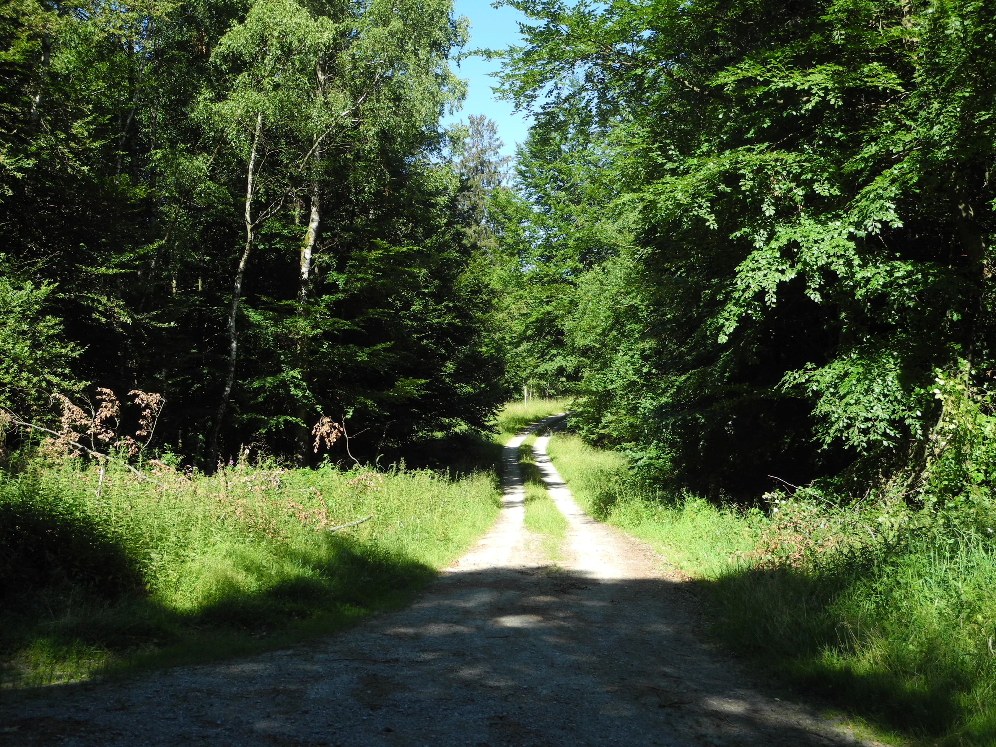
A narrow, dirt-covered forest road winds into a lush green, tree-lined woodland area under a clear blue sky.
A dirt path leading into the dense forest of the Bruchwald am Gahrenberg nature reserve.

Bruchwald am Gahrenberg history and protected-area timeline

The reserve was officially designated as a Naturschutzgebiet on 26 May 1992 under the identifying number 1633030. Its later inclusion in the FFH-Gebiet Weserhänge mit Bachläufen connected the site to the European habitat protection framework, but no detailed account of earlier land use or pre-protection history is available in the source material.

Bruchwald am Gahrenberg landscape and geographic character

The reserve occupies a gently sloping position in the southern part of the Reinhardswald, around the Sandkopf elevation. The terrain is defined less by dramatic relief than by wet, low-lying ground conditions shaped by spring seepage, with the woodland growing on Quellsümpfe that gather and slowly release water.

From these spring mires rise small headwater streams, including the sources of the Elsterbach and Rattbach, making the area a hydrological origin point for tributaries of the Fulda. The western of the two reserve parcels adds a string of small Stauteiche, dammed ponds, that punctuate the otherwise wooded ground. Patches of grassland are scattered through the forest matrix, and the reserve as a whole is largely embraced by additional forest communities of the surrounding Reinhardswald.

Bruchwald am Gahrenberg ecosystems, habitats, and plant life

Ecologically, Bruchwald am Gahrenberg is defined by its wet woodland habitats. The protected forest types include Bruchwald, marsh forest, and Moorwald, bog woodland, both communities adapted to waterlogged, often nutrient-rich or peat-influenced soils. These stands transition outward into the surrounding Rotbuchenwald, beech forest, that forms the prevailing forest type of the wider Reinhardswald, creating a gradient from wet woodland to mesic upland forest.

Where the forest thins or gives way to small clearings, narrow strips of Grünland, grassland, add a different vegetation structure. The small dammed ponds in the western parcel create still-water microhabitats within the otherwise flowing and seeping wet forest environment. Together, these features make the reserve a representative example of central German spring-mire woodland embedded in a larger forested landscape.

Bruchwald am Gahrenberg conservation status and protection priorities

The site has been protected as a Hessian Naturschutzgebiet since 26 May 1992 and is part of the FFH-Gebiet Weserhänge mit Bachläufen, anchoring its importance within the Natura 2000 network. Its classification reflects particular concern for the preservation of marsh and bog woodland communities, the integrity of spring mires, and the headwater streams that feed into the broader Fulda tributary system.

Top sights and standout views in Bruchwald am Gahrenberg

The reserve's strongest points are its protected marsh and bog woodland communities on spring mires, the headwater emergence of Fulda tributaries such as Elsterbach and Rattbach, the cluster of small Stauteiche in its western parcel, and the embedded grassland patches that diversify the forest mosaic. Integrated into both the Naturpark Reinhardswald and the FFH-Gebiet Weserhänge mit Bachläufen, it serves as a compact node within a much larger protected landscape network in northern Hesse.

Monthly climate preview

Long-term temperature ranges and precipitation statistics recorded across representative coordinates

Bruchwald am Gahrenberg Climate Normals and Average Monthly Weather Patterns

Recorded monthly climate data illustrates the long-term temperature progression and precipitation rhythm spanning representative monitoring points across Bruchwald am Gahrenberg. Inspecting the complete twelve-month record provides deeper perspective on annual meteorological averages and baseline environmental normals.
Annual mean8 °C
-1 °C18 °C
Jan-1°
Feb
Mar
Apr
May12°
Jun16°
Jul18°
Aug18°
Sep14°
Oct
Nov
Dec
Warmest month
July

18 °C

Coolest month
January

-0.6 °C

Wettest month
July

2.5 mm/day

Driest month
April

1.5 mm/day

Park location guide

Geography guide, regional context, and park location map for Bruchwald am Gahrenberg

Bruchwald am Gahrenberg park geography, regions, and map view in Germany

Understand where Bruchwald am Gahrenberg sits in Germany through a broader geographic reading of the surrounding landscape, nearby location context, and its mapped position within the national park landscape.

How Bruchwald am Gahrenberg fits into Germany

Germany is a federal republic in Western and Central Europe with a population of over 83 million across sixteen constituent states. It is Europe's largest economy by nominal GDP and a major global exporter and importer. The capital is Berlin, and the country borders Denmark, Poland, Czech Republic, Austria, Switzerland, France, Luxembourg, Belgium, and the Netherlands.

Wider geography shaping Bruchwald am Gahrenberg in Germany

Germany is located in Western and Central Europe, spanning 357,022 km². It borders Denmark to the north, Poland and the Czech Republic to the east, Austria and Switzerland to the south, and France, Luxembourg, Belgium, and the Netherlands to the west. The country has coastlines on the Baltic Sea and North Sea to the north, with the Alps located in the southern region.

Map view of Bruchwald am Gahrenberg

Use this park location map to pinpoint Bruchwald am Gahrenberg in Germany, understand its exact geographic position, and read its mapped placement within the surrounding landscape more clearly.

Pigeon | © OpenStreetMap contributors

Explore protected habitats, spring mires, and forest terrain through detailed park imagery.

Bruchwald am Gahrenberg Photos and Scenery: Visualizing Wet Woodland Landscapes

Visual documentation reveals the marsh forest habitats, spring mires, and gentle woodland terrain defining Bruchwald am Gahrenberg. Photographic records provide clear insight into the protected wetlands and headwater ecosystems embedded across the Reinhardswald massif.

A narrow, dirt-covered forest road winds into a lush green, tree-lined woodland area under a clear blue sky.

Park atlas

Compare adjacent forest reserves, wetland habitats, and regional conservation areas.

Exploring Parks Near Bruchwald am Gahrenberg and Surrounding Protected Landscapes

Browse protected areas surrounding Bruchwald am Gahrenberg to evaluate similar woodland ecosystems, spring-fed marsh terrain, and neighboring forest reserves. Comparing adjacent conservation zones reveals broader regional patterns across the wider Hessian terrain.
A soft watercolor illustration depicting a green, marshy landscape with small pools of water, a line of forest, and rolling hills in the background under a pale sky.
Nature reserveHesse
About 2.8 km away#1 closest

Northwest

Bruch an der Eichkanzel im Reinhardswald: Protected Nature Reserve Geography in Hesse

Mapped birch swamp forests and highland bog terrain

Examine the geographic profile of Bruch an der Eichkanzel im Reinhardswald, a nature reserve in Hesse defined by its upland plateau. Learn about the interaction between its birch swamp forests and open moorland habitats, characterized by sphagnum mosses and aquatic features, within the broader context of the Reinhardswald forest region.

Area
0.175 km²
Established
1992
Relief
Upland
Scope
Terrestrial
A soft watercolor illustration showing a band of green trees reflecting in calm water, with a light hilly background.
Nature reserveHessen
About 5.3 km away#2 closest

West

Bennhäuser Teich und Rothbalzer Teich bei Immenhausen: Protected Nature Reserve and Landscape Atlas

Mapped woodland and wetland habitats in Hessen, Germany.

This nature reserve centers on historic impoundment ponds and complex valley hydrology. Its landscape features rare dragonfly habitats and successional carr woodlands that define the ecological identity of this protected area within the northern Hessen countryside.

Area
0.315 km²
Established
1998
A horizontal watercolor illustration depicting rolling green hills, patches of forest, and a calm river in the foreground, rendered in soft, pastel tones.
Nature reserveHesse
About 8 km away#3 closest

Southwest

Kragenhof bei Fuldatal Nature Reserve: Mapped Floodplain Landscapes in Hesse, Germany

Protected riparian ecosystems and river meander geography

Located in the state of Hesse, Kragenhof bei Fuldatal is a significant nature reserve protecting a complex mosaic of Fulda River floodplain habitats. The area features shifting currents, small wooded islands, and open grassland within a distinctive meander-driven landscape. Explore the geographic boundaries and ecological structure of this important regional waterbird refuge.

Area
0.077 km²
Established
1981
A horizontal watercolor painting depicting a soft, atmospheric landscape with rolling green hills, a winding river or water feature, and distant pale mountains under a hazy, pastel sky.
Protected landscapeLower Saxony
About 8.3 km away#4 closest

Southeast

Naturpark Münden Protected Landscape: Geography and Regional Mapping in Lower Saxony

Forested ridges and river valleys in southern Germany

Naturpark Münden offers a detailed look at the central German low mountain range. Discover the mapping of the Kaufunger Wald and Bramwald, the significance of the Fulda and Werra river confluences, and the structure of this historically significant protected landscape located in Lower Saxony.

Area
374 km²
Established
1959
Relief
Mountain
Water
Major water bodies
Watercolor painting of a calm wetland landscape with soft green trees along the water edge under a light, misty sky.
Nature reserveHessen
About 8.7 km away#5 closest

West

Rothenberg bei Burguffeln Protected Wetland Landscape and Nature Reserve in Hessen

A specialized pond and meadow mosaic in the Hessian lowlands

Rothenberg bei Burguffeln preserves a vital wetland complex near Immenhausen, structured across three distinct sections, including the Rothenküler Teich and Tonkaule. The area represents a significant example of culturally shaped lowland geography, blending historic aquaculture with contemporary habitat management. Its protected status reflects a commitment to maintaining intricate riparian corridors and meadow ecosystems within the wider Hessian countryside.

Area
0.278 km²
Established
1983
A horizontal watercolor illustration depicting a river flowing through a lush green floodplain with trees and distant hills under a soft, light-colored sky.
Nature reserveHessen
About 11 km away#6 closest

South

Fuldaschleuse Wolfsanger Nature Reserve: Geography and Protected Riverine Terrain

A restored floodplain ecosystem in the Hessen region.

Fuldaschleuse Wolfsanger stands as a masterfully restored nature reserve along the River Fulda. This compact 14-hectare site features a man-made island, shallow-water zones, and softwater floodplain forests that support over 120 bird species. Its layout provides a rare example of integrated conservation within a modern urban-edge environment, demonstrating the success of deliberate floodplain engineering for biodiversity.

Area
0.14 km²
Established
1985
IUCN
IV
A soft watercolor illustration of a winding stream flowing through a green meadow with rolling hills in the background and a small cluster of pine trees in the foreground.
Nature reserveHessen
About 11 km away#7 closest

West

Jungfernbach und Brandteich bei Calden: Protected Forest and Stream Valley Geography

Regional nature reserve landscape located in northern Hessen

Examine the mapped boundaries and natural terrain of Jungfernbach und Brandteich bei Calden. This nature reserve offers a detailed look at lowland stream corridors, pond ecosystems, and riparian forest patches nestled within the rolling landscape of northern Hessen, reflecting the region's diverse protected land character.

Area
0.343 km²
Established
1985
A watercolor painting showing a tranquil river landscape with soft green hills and reflections in calm water.
Nature reserveHessen
About 13 km away#8 closest

North

Ochsenhof Nature Reserve: Wetland Geography and Weser Floodplain Protected Areas

A riparian landscape mosaic in northern Hessen, Germany.

Located at the border of the vast Reinhardswald forest, Ochsenhof protects a valuable riverine corridor featuring reclaimed gravel-pit lakes and diverse wetland vegetation. This nature reserve provides essential habitat for waterfowl along the Weser, functioning as a sheltered landscape pocket within the regional protected-area network of northern Hessen.

Area
0.24 km²
Established
1981
IUCN
IV

Common questions about visiting, size, designation, and location context for Bruchwald am Gahrenberg

Bruchwald am Gahrenberg FAQs for park facts, access, geography, and protected area context

Find quick answers about Bruchwald am Gahrenberg, including protected-area facts, park geography, trail and visitor context, and how the park fits into its surrounding country and regional landscape.
MoriAtlas Explorer

Continue Your Protected Areas Search Across the Global Atlas

Deepen your exploration by continuing the structured search for national parks and protected areas worldwide. Utilize the comprehensive filtering capabilities to compare different conservation landscapes and refine your understanding of global park geography. Discover more about the distribution and characteristics of protected natural areas.

Global natural geography