
Mori Atlas logo
Nature reserveBuchenberg bei Krölpa

Examining the ecological terrain and geographic boundaries of this unique former limestone quarry site.

Buchenberg bei Krölpa Nature Reserve: A Mapped Protected Landscape in Thuringia, Germany

Buchenberg bei Krölpa is a compact nature reserve situated within the Saale-Orla-Kreis region of Thuringia. This protected area offers a distinct study in post-industrial ecological recovery, where the rugged terrain of a former limestone quarry now provides essential habitat for specialized calcareous flora. The landscape is defined by rocky slopes, exposed substrates, and developing dry grassland that illustrate the transformation of industrial land into a managed conservation zone.

nature reserveThuringiaSaale-Orla-Kreisformer quarrylimestone habitatcalcareous grassland
A stylized vector illustration of a forested mountain valley with a tiered waterfall flowing over a cliff into a stream, featuring pine trees, distant hills, and a sunrise.

Buchenberg bei Krölpa

Nature reserve

Park overview

Structured park overview, official facts, and landscape profile for Buchenberg bei Krölpa

Buchenberg bei Krölpa park facts, protected area profile, and essential visitor context

Review the core facts for Buchenberg bei Krölpa, including designation, size, terrain, visitor scale, habitats, and operating context in one park-focused overview.

About Buchenberg bei Krölpa

Buchenberg bei Krölpa is a compact nature reserve in eastern Thuringia, a region of central Germany marked by rolling hills, small river valleys, and a long tradition of limestone quarrying. The reserve sits east of Krölpa, on the municipal area of Ranis in the Saale-Orla-Kreis, with the federal road B 281 running along its northern edge. To the north flows the Kotschaubach, a small tributary of the Orla, while local roads frame the site to the west and east, giving the protected area a clearly defined position in the local landscape.

The meaning of the reserve lies less in its physical extent than in what it represents ecologically. At about 20 hectares, it is a small but purposeful protected landscape, dedicated to habitat and species management. The terrain is the product of the site's industrial past: the Buchenberg was quarried for steelworks lime and agricultural lime from 1943 to 1978, then served as a military training area until 1989. After German reunification the land passed through the Treuhand privatization agency, and the technical quarry installations were cleared in 1994, opening the way for formal nature protection, which was achieved with designation in 1996.

Since 2002 the reserve has been owned by the Thuringia branch of the Arbeitskreise Heimische Orchideen, a specialist organization focused on the conservation of native orchid species. This custodianship shapes how the area is understood and managed, anchoring the site's identity in the recovery and maintenance of calcareous habitats that support native orchid communities. It is a textbook example of how a small former extraction site can be reintegrated into the regional network of protected areas for long-term ecological value.

Quick facts and research context for Buchenberg bei Krölpa

Buchenberg bei Krölpa is a protected nature reserve in Thuringia, Germany, falling within the Saale-Orla-Kreis district and lying east of Krölpa near the town of Ranis. It is classified as a Naturschutzgebiet under German nature protection law and corresponds to IUCN Category IV (Habitat/Species Management Area), with WDPA ID 162606. The site covers about 20.1 hectares and was formally designated for nature protection in 1996, after decades of prior industrial and military use left the land available for ecological rehabilitation.

Protection and recognition

Review the official terrestrial designation records and management framework for Buchenberg bei Krölpa.

Buchenberg bei Krölpa Protection Status and Documented Conservation Scope

Buchenberg bei Krölpa maintains a documented terrestrial protection status within global conservation databases. Verified administrative records outline the official designation framework and management scope for this protected area.

Protection details

Protection scope
Terrestrial
Transboundary protection
No
WDPA ID
162606
Park context

Deeper park guide and search-rich context for Buchenberg bei Krölpa

Buchenberg bei Krölpa history, landscape, wildlife, and travel context

Explore Buchenberg bei Krölpa through its history, landscape character, ecosystems, wildlife, conservation priorities, cultural context, and seasonal travel timing in a structured park guide built for atlas discovery and search intent.

Why Buchenberg bei Krölpa stands out

The reserve is best known as a former limestone quarry that has been transformed into a protected area valued for its calcareous, orchid-friendly habitats. Its current custodianship by the Thuringian native orchid working group gives the site a clear botanical identity, centered on the dry grassland, scrub, and rocky habitats that develop on old quarry slopes and provide the conditions favored by many native orchid species.
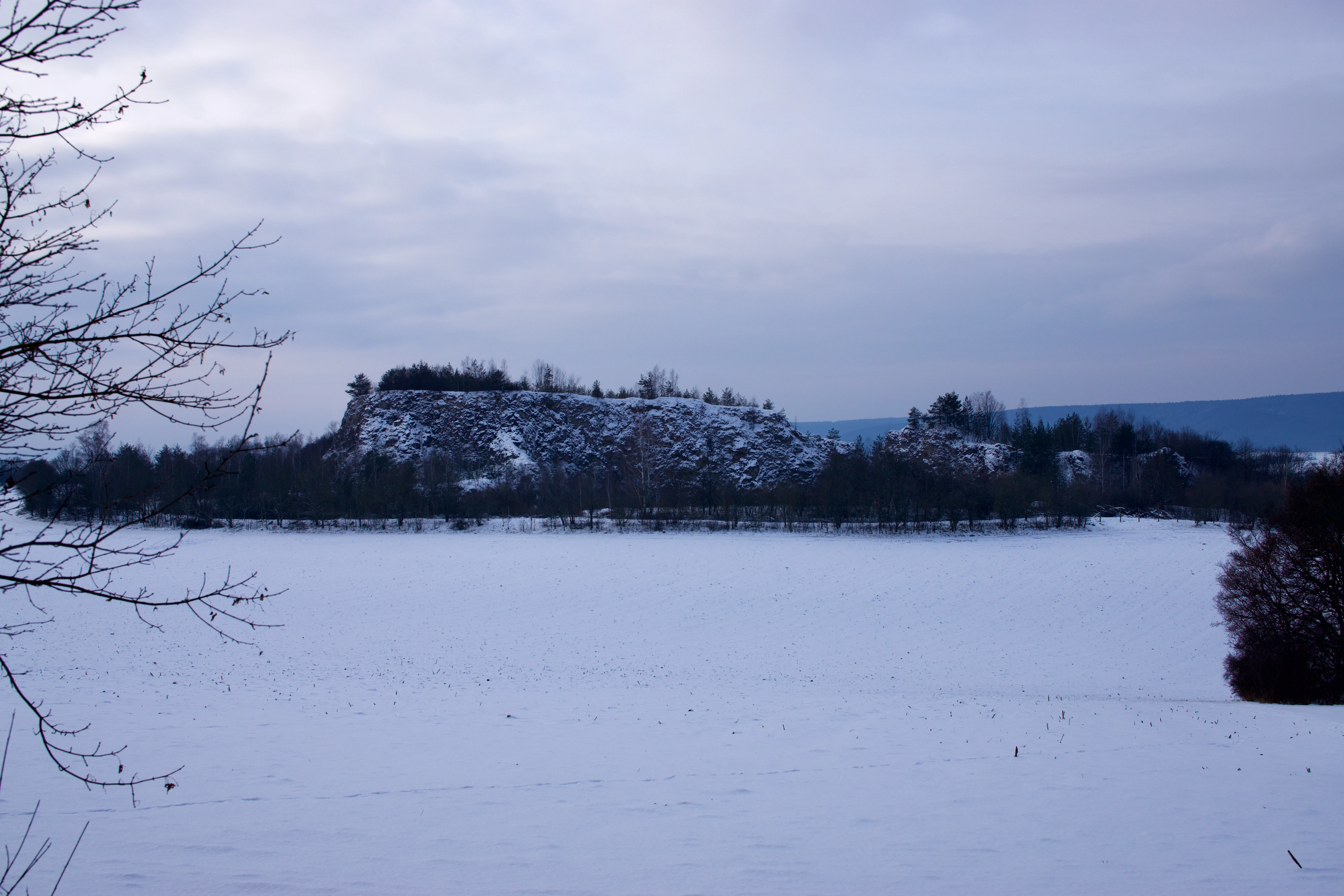
A wide, eye-level landscape shot of a snow-covered hill known as Buchenberg, set against a cloudy winter sky with a snowy field in the foreground.
View of Buchenberg near Krölpa, Thuringia, during winter.

Buchenberg bei Krölpa history and protected-area timeline

The history of Buchenberg bei Krölpa is closely tied to industrial and military use before the land became a nature reserve. From 1943 to 1978, the Buchenberg was actively quarried for limestone, supplying both steelworks lime and agricultural lime. After the quarrying era, the site was repurposed from 1978 to 1989 as a military training ground, putting further pressure on the terrain and limiting any natural recovery during that period.

Following the political changes in Germany in 1989, the area came under the Treuhandanstalt, the agency responsible for privatizing former state-owned assets in the eastern German states. In 1994 the technical installations associated with the old quarry were dismantled, marking the practical end of the site's industrial era. Formal nature protection followed in 1996, when the approximately 20-hectare area was designated as a Naturschutzgebiet with the designation number 275.

A defining step came in 2002, when ownership passed to the Arbeitskreis Heimische Orchideen Thüringens, the Thuringian working group of the native orchid conservation network. This transfer gave the reserve a clear conservation focus and an institutional custodian whose mission aligns with the habitat qualities that old limestone quarries can develop once disturbance ends.

Buchenberg bei Krölpa landscape and geographic character

The landscape of the Buchenberg bei Krölpa reserve is shaped above all by its quarrying history. Decades of limestone extraction left the hill with worked rock faces, ledges, scree, and altered slopes, and these geological features now form the structural backbone of the protected area. Rather than a smooth, continuous woodland or meadow landscape, the terrain has the broken, stepped character typical of a former extraction site, with exposed calcareous substrates, shallow soils, and pockets of vegetation that colonize the disturbed ground.

Within the broader regional setting, the reserve sits in a part of Thuringia where small valleys, low hills, and tributary streams define the countryside. The Kotschaubach, a left-bank tributary of the Orla, flows along the northern side of the area, while roads including the B 281 and the L 2367 mark nearby boundaries. This gives the site a clear, contained footprint within an otherwise traditionally rural Thuringian landscape.

The combination of exposed limestone, old quarry structures, and the gradual return of dry grassland and scrub gives the Buchenberg its distinctive visual character. The slopes and rock faces, once stripped by mining, are now a mosaic of regenerating vegetation that defines both the scenery and the ecological value of the place.
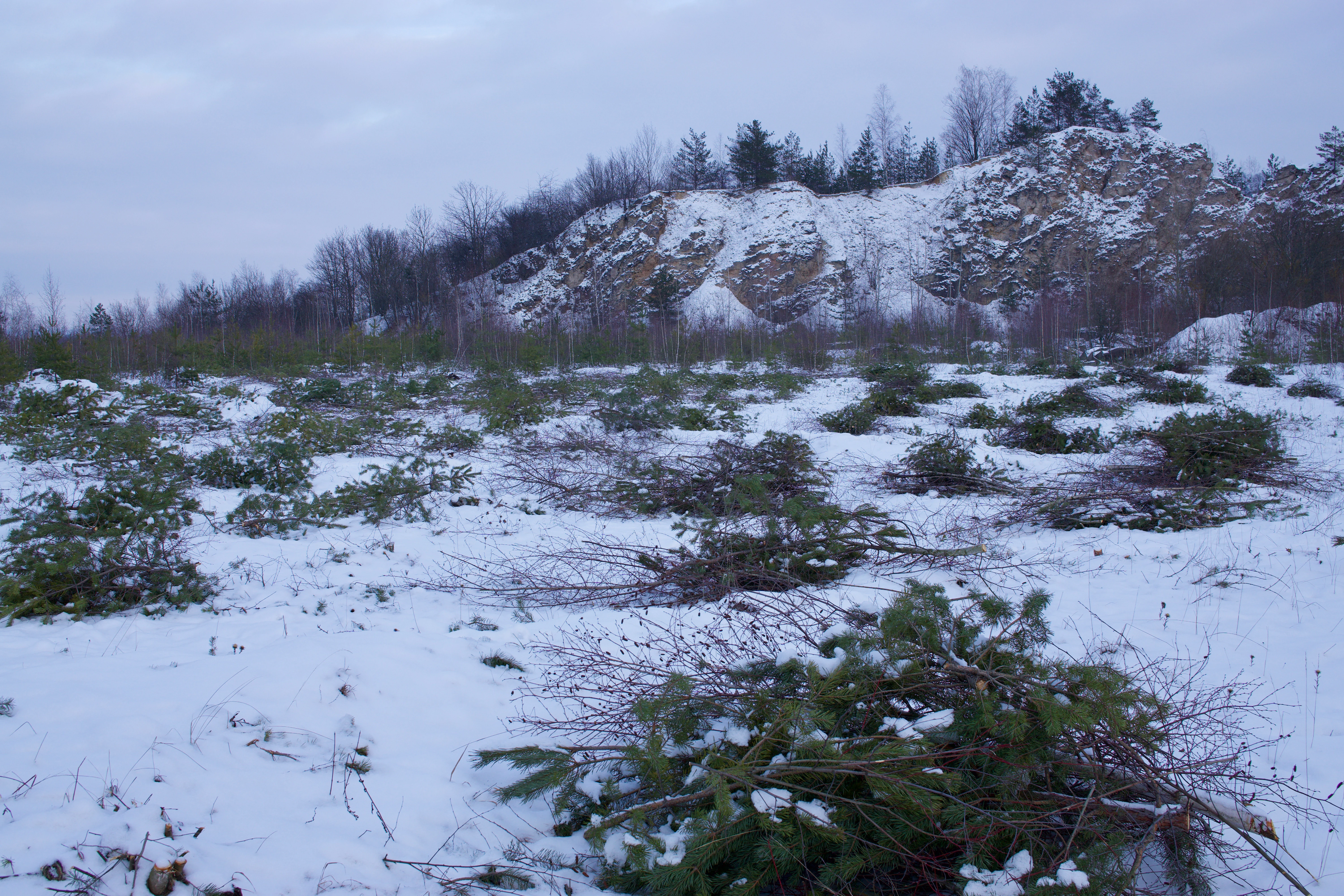
A snowy, open landscape in a nature reserve featuring scattered cut pine branches in the foreground and a rocky, snow-dusted hillside with trees in the background.
Winter landscape in the Buchenberg bei Krölpa nature reserve showing vegetation management.

Buchenberg bei Krölpa ecosystems, habitats, and plant life

Ecologically, the reserve is dominated by calcareous habitats that have developed on the former limestone quarry. Exposed limestone, thin soils, and warm rock surfaces create conditions favorable for dry grassland and specialized rock-community vegetation, while flatter areas allow scrub and low woodland to establish over time. Such habitat mosaics are characteristic of older quarry sites in central Germany and support a notable diversity of plants adapted to mineral-rich, drought-prone substrates.

The most distinctive ecological theme of the reserve is its importance for native orchids, which flourish in open, calcareous conditions. The site's ownership by the Thuringia branch of the Arbeitskreise Heimische Orchideen strongly suggests that orchid conservation, and the management of the dry grassland, scrub, and rock habitats they depend on, sits at the heart of the reserve's ecological identity.

The protected area status itself, classified as a Naturschutzgebiet under German law and as an IUCN Category IV Habitat/Species Management Area, reflects a management-oriented approach. Rather than being set aside as untouched wilderness, the Buchenberg is treated as an actively managed habitat complex, where interventions such as clearing, grazing, or targeted species support may be used to maintain the special flora on the old quarry slopes.

Buchenberg bei Krölpa wildlife and species highlights

Because the source material emphasizes the site's botanical and habitat-management profile rather than its fauna, detailed wildlife descriptions would be speculative. What can be said with confidence is that the mosaic of dry grassland, scrub, rock faces, and regenerating vegetation on the former quarry creates habitat structure typical for invertebrates, reptiles, and small mammals that use warm, open, calcareous terrain. Such sites in Thuringia often host characteristic butterfly, moth, and solitary bee communities, as well as reptile species that favor sun-exposed rocky slopes. The reserve's orchid-rich vegetation also implies an associated fauna of pollinators tied to these flowering plants.

Buchenberg bei Krölpa conservation status and protection priorities

The conservation significance of Buchenberg bei Krölpa lies in its role as a successful transition from industrial exploitation to habitat protection. The site's protection history, from post-1989 Treuhand custody through designation in 1996 to transfer to the Thuringia orchid working group in 2002, illustrates how former quarries and military areas can be redirected toward long-term ecological value. Under IUCN Category IV, the reserve is explicitly framed as a Habitat/Species Management Area, meaning conservation measures focus on maintaining particular habitats and the species associated with them rather than on preserving untouched natural processes.

The custodianship by the Arbeitskreis Heimische Orchideen Thüringens is a defining feature of the site's conservation profile. Working groups within the native orchid network typically focus on monitoring, habitat management, and public engagement around orchid-rich sites, so the reserve is likely to benefit from targeted management aimed at keeping canopy and scrub cover from overwhelming the open calcareous vegetation that orchids require.

In the wider regional context, the reserve forms part of the network of Naturschutzgebiete im Saale-Orla-Kreis, contributing to the broader pattern of protected sites in eastern Thuringia that together safeguard calcareous, grassland, woodland, and aquatic habitats across the district. As a compact but specialized quarry-site reserve, the Buchenberg adds a specific habitat type to this mosaic.

Buchenberg bei Krölpa cultural meaning and human context

The cultural context of the Buchenberg bei Krölpa reserve is modest and primarily industrial rather than traditional. The hill's identity was shaped by mid-twentieth-century limestone quarrying for steel and agriculture, followed by military use that effectively closed the area to the public for several decades. After 1989 and reunification, the transition of the land through the Treuhand privatization agency marked an important moment in the broader social and economic transformation of eastern Germany, with this hill becoming one of many former extraction and military sites repurposed into protected natural areas.

Local engagement today is reflected in the reserve's ownership by the Thuringian native orchid working group, an example of how regional specialist associations take direct responsibility for managing small but ecologically meaningful sites. This model of civil-society custodianship is part of the wider German tradition of organized nature conservation through dedicated working groups and volunteer associations.

Top sights and standout views in Buchenberg bei Krölpa

A former limestone quarry transformed into a compact, management-focused nature reserve in Thuringia. The site is notable for its calcareous habitats and strong association with native orchid conservation, with ownership held by the Thuringian branch of the native orchid working group since 2002. Its position in the Saale-Orla-Kreis near Ranis and Krölpa, combined with a history spanning quarrying, military use, and ecological recovery, makes it a regionally distinctive example of post-industrial habitat rehabilitation.

Best time to visit Buchenberg bei Krölpa

Given the reserve's emphasis on dry grassland and calcareous vegetation on warm rock slopes, late spring through early summer is generally the most rewarding period for observing the open habitats and any flowering orchid populations that the site is managed to support. Early visits in mild spring weather can also be pleasant for walking the terrain of the former quarry and appreciating the mosaic of rock, scrub, and developing grassland. Visitors should treat seasonality primarily as a matter of ecological and scenic interest rather than assuming any formal access arrangements, and they should respect that the reserve is primarily a conservation site rather than a public recreation area.

Monthly climate preview

Long-term representative point measurements tracking monthly averages across the protected terrain

Buchenberg bei Krölpa Climate Normals and Annual Temperature Rhythm

Representative coordinate records show measured temperature swings from sub-zero winter minimums to warm summer maximums alongside steady daily precipitation rates. Examining the full twelve-month profile provides deeper analytical context for long-term climatological trends across the protected area.
Annual mean8 °C
-2 °C18 °C
Jan-2°
Feb-1°
Mar
Apr
May12°
Jun16°
Jul18°
Aug18°
Sep13°
Oct
Nov
Dec-1°
Warmest month
July

18 °C

Coolest month
January

-2.1 °C

Wettest month
July

2.7 mm/day

Driest month
April

1.4 mm/day

Park location guide

Geography guide, regional context, and park location map for Buchenberg bei Krölpa

Buchenberg bei Krölpa park geography, regions, and map view in Germany

Understand where Buchenberg bei Krölpa sits in Germany through a broader geographic reading of the surrounding landscape, nearby location context, and its mapped position within the national park landscape.

How Buchenberg bei Krölpa fits into Germany

Germany is a federal republic in Western and Central Europe with a population of over 83 million across sixteen constituent states. It is Europe's largest economy by nominal GDP and a major global exporter and importer. The capital is Berlin, and the country borders Denmark, Poland, Czech Republic, Austria, Switzerland, France, Luxembourg, Belgium, and the Netherlands.

Wider geography shaping Buchenberg bei Krölpa in Germany

Germany is located in Western and Central Europe, spanning 357,022 km². It borders Denmark to the north, Poland and the Czech Republic to the east, Austria and Switzerland to the south, and France, Luxembourg, Belgium, and the Netherlands to the west. The country has coastlines on the Baltic Sea and North Sea to the north, with the Alps located in the southern region.

Map view of Buchenberg bei Krölpa

Use this park location map to pinpoint Buchenberg bei Krölpa in Germany, understand its exact geographic position, and read its mapped placement within the surrounding landscape more clearly.

Pigeon | © OpenStreetMap contributors

Location context for Buchenberg bei Krölpa

Thuringia

Visual exploration of limestone rock faces, calcareous habitats, and regenerating quarry terrain in Thuringia

Buchenberg bei Krölpa Photos and Landscape Scenery

Visual documentation captures the unique topography and ecological character of the protected area, highlighting exposed limestone ledges and recovering dry grassland slopes. Photographic records provide clear insight into the complex terrain and botanical habitats that define the former industrial landscape.

A wide, eye-level landscape shot of a snow-covered hill known as Buchenberg, set against a cloudy winter sky with a snowy field in the foreground.

A snowy landscape view of a nature reserve featuring sparse trees, small evergreen shrubs, and a forested horizon line under a pale overcast sky.

A snowy, open landscape in a nature reserve featuring scattered cut pine branches in the foreground and a rocky, snow-dusted hillside with trees in the background.

Park atlas

Discover related reserves and surrounding Thuringian landscapes for deeper comparison

Explore Protected Areas and Parks Near Buchenberg bei Krölpa

Compare Buchenberg bei Krölpa with other protected areas across the surrounding regional terrain. Broaden your geographic exploration by examining nearby nature reserves and habitat management zones.
A horizontal watercolor painting showing a soft, stylized landscape of rolling green hills, gentle slopes, and a calm body of water against a light pastel sky.
Nature reserveThuringia
About 12 km away#1 closest

East

Plothener Teiche Nature Reserve: Geographic Map and Protected Wetland Landscape Overview

Historic pond landscapes in the Saale-Orla-Kreis region of Thuringia

Plothener Teiche serves as a defining example of medieval-origin fishpond management in central Germany. This protected landscape combines open water basins, reed-lined margins, and woodland edges within the Thüringer Schiefergebirge and Obere Saale Nature Park. The area provides essential habitat for migratory bird populations and stands as a restored model of European wetland ecology.

Established
1967
IUCN
IV
Relief
Lowland
Climate
Temperate
A horizontal watercolor illustration showing green rolling hills, distant light green ridges, and sparse trees against a white background.
Nature reserveThuringia
About 20 km away#2 closest

North

Spitzenberg-Schießplatz Rothenstein-Borntal Nature Reserve and Saale Valley Geography

Protected forest and grassland terrain in Thuringia

Spitzenberg-Schießplatz Rothenstein-Borntal is a protected nature reserve in Thuringia, covering hundreds of hectares of forest slopes, plateaus, and open clearings. This reserve is recognized for its unusual structural diversity, ranging from closed valley woodland to sun-exposed semi-dry grassland, providing essential habitat within the middle Saale valley region.

Area
5.542 km²
Established
1961
IUCN
IV
A horizontal watercolor illustration showing soft green hills, forest patches, and distant pale pink mountains.
Nature reserveThuringia
About 20 km away#3 closest

Southeast

Kobersfelsen Nature Reserve: Silicate Cliff Geography and Protected Valley Landscapes

Geographic context for the Thuringian Slate Mountains protected area.

Kobersfelsen features a significant silicate rock outcrop rising above the Saale valley. As part of a larger Habitats Directive site, this nature reserve integrates cliffside forest with rare botanical communities. Users can examine the specific site boundaries and understand its role within the wider ecological network of the Thuringian region.

Area
0.06 km²
Established
1989
IUCN
IV
Relief
Upland
Protected landscapeBavaria
About 20 km away#4 closest

South

Naturpark Frankenwald: Geographic Profile of Bavaria's Forested Protected Landscape

A vast, interconnected upland spanning the Bavaria and Thuringia border

Naturpark Frankenwald functions as a large-scale managed nature preserve that integrates cultural heritage with ecological conservation. The terrain consists of gentle mountainous ridges, narrow river valleys, and extensive mixed forests that form a continuous landscape belt across northern Bavaria. This profile provides an overview of the regional geography, boundary extent, and the natural features that define this significant central German upland area.

Area
1,023 km²
Established
1973
Relief
Upland
Climate
Temperate
Nature reserveThuringia
About 21 km away#5 closest

North

Leutratal und Cospoth Nature Reserve: Mapping Calcareous Grasslands in Thuringia

A study of limestone slopes and orchid-rich habitats in central Germany

Leutratal und Cospoth serves as a prime example of protected Muschelkalk landscape in Thuringia. This reserve captures the complex transition between open grasslands, scrub, and beech forests within the middle Saale valley, offering deep insights into the region's unique geological and botanical heritage.

Area
5.829 km²
Established
1961
IUCN
IV
Relief
Upland
A soft watercolor painting of a green landscape with trees, rolling hills, and a body of water under a light sky.
Nature reserveThuringia
About 24 km away#6 closest

North

Jenaer Forst Nature Reserve: Mapping the Protected Limestone Plateau and Forest Terrain

Protected nature reserve in Thuringia, Germany

Jenaer Forst is a 540 hectare nature reserve in Thuringia, characterized by dry calcareous woodland and active restoration work. The site is a study in landscape recovery, balancing forest management with the protection of orchid-rich habitats on its limestone plateau. This detailed atlas entry provides insights into the park boundaries, geological features, and ecological significance of this peri-urban forest zone.

Area
5.411 km²
Established
2008
IUCN
IV
Nature reserveWeimarer Land
About 24 km away#7 closest

Northwest

Seeteich Blankenhain Nature Reserve: Geographic Map and Protected Area Context

Wetland landscape situated in the Weimarer Land district

Seeteich Blankenhain is a distinct nature reserve in Germany, characterized by its historic pond and surrounding moist lowland ecosystems. This site remains a focal point for ecological research and conservation, offering a layered landscape of reed zones and woodland that supports a diverse bird community. Its presence within the regional geography of Weimarer Land highlights the importance of small-scale wetland preservation in the Thuringian landscape.

Established
1991
Relief
Lowland
Access
Access unknown
Scope
Terrestrial
A soft watercolor illustration showing gentle, rolling green hills and a small patch of wildflowers in the foreground on a white background.
Protected areaThuringia
About 29 km away#8 closest

West

Großer Kalmberg Protected Area: Geography and Landscape of the Ilm-Saale-Platte

Examining the asymmetric summit and calcareous habitats in central Thuringia.

Großer Kalmberg rises as a focal point of the Ilm-Saale-Platte, offering a clear view into the geological history of the region. This summit integrates pine-forested slopes with protected dry grasslands and rocky outcrops, creating a complex mosaic of terrain that characterizes this part of Thuringia.

Area
2.64 km²
Established
1999
Relief
Mountain
Climate
Temperate

Common questions about visiting, size, designation, and location context for Buchenberg bei Krölpa

Buchenberg bei Krölpa FAQs for park facts, access, geography, and protected area context

Find quick answers about Buchenberg bei Krölpa, including protected-area facts, park geography, trail and visitor context, and how the park fits into its surrounding country and regional landscape.
MoriAtlas Explorer

Continue Your Protected Areas Search Across the Global Atlas

Deepen your exploration by continuing the structured search for national parks and protected areas worldwide. Utilize the comprehensive filtering capabilities to compare different conservation landscapes and refine your understanding of global park geography. Discover more about the distribution and characteristics of protected natural areas.

Global natural geography