Mori Atlas logo
National parkBui National Park

Discover the mapped boundaries and unique ecosystems of this significant national park in Ghana.

Bui National Park: Ghana's Protected Savanna Landscape and Black Volta River Geography

Bui National Park in Ghana offers a profound exploration of a protected savanna ecosystem dramatically carved by the Black Volta River. Spanning approximately 1,820 square kilometers across Ghana's Bono and Savannah Regions, this national park presents a unique geographic tapestry where riparian corridors meet woodland savanna. Users can discover the park's mapped boundaries, its significant hippopotamus populations congregating in the river's waters, and its vital status as an Important Bird Area for West African avifauna. The interplay of riverine landscapes, savanna terrain, and surrounding mountainous features makes Bui National Park a key destination for understanding Ghana's natural heritage from an atlas perspective.

National ParkGhanaSavannaBlack Volta RiverHippopotamusImportant Bird Area

Bui National Park

National park

Park overview

Structured park overview, official facts, and landscape profile for Bui National Park

Bui National Park park facts, protected area profile, and essential visitor context

Review the core facts for Bui National Park, including designation, size, terrain, visitor scale, habitats, and operating context in one park-focused overview.

About Bui National Park

Bui National Park represents one of Ghana's largest and most ecologically significant protected areas, encompassing a diverse landscape of woodland savanna, riparian forests, and the central channel of the Black Volta River. The park's location in central Ghana places it at a biogeographic crossroads, where West African savanna ecosystems meet more humid forest zones, creating a mosaic of habitats that supports remarkable biodiversity. The Black Volta River serves as the park's defining geographic feature, not only bisecting the protected area but also providing critical aquatic habitat for the park's famous hippopotamus population. Beyond its ecological significance, Bui National Park holds importance for regional conservation as part of a transboundary landscape that extends toward Ivory Coast. The construction of the Bui Dam between 2007 and 2013 introduced a significant new feature to the park, with the reservoir inundating portions of the protected area and creating additional aquatic habitat. This major infrastructure project altered the park's character but also created new opportunities for wildlife observation, as hippos and waterbirds now utilize the expansive reservoir.

Quick facts and research context for Bui National Park

Bui National Park covers 1,820 km² of central Ghana, straddling the Bono and Savannah Regions along the Black Volta River. The park was established in 1971 and is classified as an IUCN Category II protected area. It is renowned for its large hippopotamus population in the Black Volta and serves as a critical habitat for the endangered ursine colobus. The park's diverse avifauna includes species such as violet turacos, Senegal parrots, and bearded barbets, earning it Important Bird Area status. The Bui Dam, constructed between 2007 and 2013, created a reservoir that inundated a portion of the park, adding a significant lacustrine element to the protected landscape.

Protection and recognition

Documenting the official management scope, boundary status, and conservation framework of the park.

Bui National Park Protection Status and Conservation Designations

Bui National Park features a mixed protection scope that structures the conservation of its regional geography and native habitats. Reviewing official boundary designations and management frameworks provides essential context for understanding regional conservation efforts.

Protection details

Protection scope
Mixed
Transboundary protection
No
Park context

Deeper park guide and search-rich context for Bui National Park

Bui National Park history, landscape, wildlife, and travel context

Explore Bui National Park through its history, landscape character, ecosystems, wildlife, conservation priorities, cultural context, and seasonal travel timing in a structured park guide built for atlas discovery and search intent.

Why Bui National Park stands out

Bui National Park is best known for its exceptional hippopotamus population, which thrives in the waters of the Black Volta River that bisects the park. The savanna environment supports the endangered ursine colobus, a primate species of significant conservation concern. The park's designation as an Important Bird Area highlights its importance for West African birdlife, with species including violet turacos, red-throated bee-eaters, Senegal parrots, and Heuglin's masked weavers among the notable residents. The dramatic landscape, where the Black Volta cuts through woodland savanna surrounded by mountainous terrain, creates a visually striking protected area that combines riverine, savanna, and forest habitats.

Bui National Park history and protected-area timeline

Bui National Park was established in 1971 as Ghana's commitment to preserving its savanna ecosystems and the unique biodiversity they support. The park's creation reflected growing recognition during the mid-twentieth century of the need to protect West Africa's woodland savanna environments, which face pressures from agricultural expansion and human settlement. Initially spanning the full extent of its current territory, the park's history took a significant turn with the construction of the Bui Dam beginning in 2007. The hydroelectric dam, completed in 2013, created a large reservoir that flooded portions of the park, altering the landscape and creating a substantial artificial lake within the protected area. This development introduced new challenges for park management while also expanding aquatic habitats. The park's designation as an Important Bird Area by BirdLife International represents an important milestone in its conservation recognition, acknowledging the global significance of its bird populations.

Bui National Park landscape and geographic character

The landscape of Bui National Park is defined by the interplay between the Black Volta River and the surrounding woodland savanna terrain. The Black Volta, one of Ghana's major rivers, flows through the heart of the park, creating a riparian corridor that contrasts with the broader savanna environment. Along the riverbanks, denser vegetation zones provide habitat diversity, while the surrounding areas feature the characteristic mix of grasses, shrubs, and scattered trees typical of West African savanna. The park's terrain includes mountainous areas that rise from the savanna floor, with features like Sunshine Mountain offering panoramic views over the protected landscape. The creation of the Bui reservoir added a significant lacustrine element to the park, transforming portions of the floodplain into a vast expanse of open water surrounded by the park's rolling savanna and forested slopes.

Bui National Park ecosystems, habitats, and plant life

Bui National Park protects a representative sample of West African woodland savanna ecosystem, characterized by a mixture of grassland and deciduous woody vegetation adapted to the seasonal climate patterns of the region. The park's location straddles the boundary between Ghana's forest zone and the more open savanna environments to the north, creating ecological diversity within its boundaries. The Black Volta River and its associated wetlands provide riparian and aquatic habitats that contrast with the surrounding terrestrial savanna, supporting different ecological communities. The park's vegetation supports various mammal and bird species adapted to savanna environments, while the river system provides crucial water resources for wildlife throughout the dry season. The combination of terrestrial and aquatic habitats within a relatively intact savanna landscape makes Bui nationally significant for biodiversity conservation.

Bui National Park wildlife and species highlights

Bui National Park is renowned for its substantial hippopotamus population, which represents one of the park's most notable wildlife features. These large mammals congregate in the waters of the Black Volta River and the Bui reservoir, where they can be observed swimming and resting during daytime hours. The endangered ursine colobus represents a primate species of particular conservation significance within the park, inhabiting the more forested areas along the river corridors. The park supports diverse antelope species typical of West African savanna, providing important habitat for these herbivores within the protected landscape. The avian fauna is exceptionally diverse, with the park's Important Bird Area status reflecting the presence of significant populations of species including violet turacos, red-throated bee-eaters, bearded barbets, Senegal parrots, yellow-billed shrikes, Senegal eremomelas, oriole warblers, white-crowned robin-chats, and Heuglin's masked weavers. This rich bird community utilizes the various habitats within the park, from riverine zones to savanna woodlands.

Bui National Park conservation status and protection priorities

Bui National Park holds significance as a protected area preserving Ghana's woodland savanna ecosystems and the biodiversity they support. The park's designation as an Important Bird Area by BirdLife International acknowledges its international importance for bird conservation, particularly for West African species whose populations depend on intact savanna habitats. The presence of the endangered ursine colobus elevates the park's conservation importance, as this primate species faces significant population pressures across its range. The protected area serves as a refuge for wildlife in a region where savanna ecosystems face pressures from agricultural expansion and human development. Management of the park must balance conservation objectives with the reality of the Bui Dam's presence, as the reservoir both created new habitats and altered portions of the original ecosystem.

Bui National Park cultural meaning and human context

Bui National Park is situated in central Ghana among communities whose traditional livelihoods include agriculture and fishing. The local communities in the surrounding Bono and Savannah Regions maintain connections to the land that now falls within the protected area, though detailed information about specific cultural or historical relationships with the landscape is limited in available sources. The park's proximity to Ivory Coast places it in a border region where cross-border dynamics may influence both human activity and wildlife movement patterns.

Top sights and standout views in Bui National Park

The Black Volta River remains the defining highlight of Bui National Park, providing habitat for the park's celebrated hippopotamus population and creating a scenic waterway that bisects the savanna landscape. The mountainous terrain surrounding the reservoir offers elevated viewpoints such as Sunshine Mountain, from which visitors can appreciate the park's geographic character. The Bui reservoir itself has become a notable feature, allowing boat-based wildlife observation where hippos and waterbirds can be viewed in the lacustrine environment. The park's birdlife, recognized through its Important Bird Area designation, represents a major highlight for ornithologists and nature enthusiasts, with species like the violet turaco adding color to the savanna environment.

Best time to visit Bui National Park

The optimal time to visit Bui National Park falls within the dry season months from November to April, when wildlife tends to concentrate near the river and reservoir as surrounding water sources become scarce. This period offers the best opportunities for hippopotamus observation along the Black Volta, as the animals remain in the permanent water bodies. The dry season also provides more comfortable conditions for park exploration and wildlife viewing. The wet season from May to October transforms the landscape with fresh vegetation but can make some areas less accessible and wildlife more dispersed. Bird observation remains rewarding throughout the year, though the dry season may concentrate bird activity around water sources.
Monthly climate preview

Analyze long-term temperature averages and seasonal precipitation cycles across the reserve

Bui National Park Climate Normals and Monthly Weather Averages

Long-term measurements show a clear transition from hot, dry conditions with temperatures peaking near thirty degrees Celsius to a wetter interval peaking later in the annual cycle. Accessing the complete twelve-month climate profile reveals precise daily precipitation averages and temperature ranges mapped across the year.
Annual mean27 °C
25 °C30 °C
Jan27°
Feb29°
Mar30°
Apr29°
May28°
Jun27°
Jul26°
Aug25°
Sep26°
Oct26°
Nov27°
Dec26°
Warmest month
March

29.8 °C

Coolest month
August

25.4 °C

Wettest month
September

6.1 mm/day

Driest month
January

0.1 mm/day

Park location guide

Geography guide, regional context, and park location map for Bui National Park

Bui National Park park geography, regions, and map view in Ghana

Understand where Bui National Park sits in Ghana through a broader geographic reading of the surrounding landscape, nearby location context, and its mapped position within the national park landscape.

How Bui National Park fits into Ghana

Ghana, officially the Republic of Ghana, is a West African nation spanning approximately 240,000 km² along the Gulf of Guinea. It achieved independence from Britain in 1957, becoming the first Sub-Saharan colony to do so, and transitioned to a republic in 1960. The country has a population of over 35 million, with Accra as its capital and largest city. Ghana features diverse ecosystems from coastal savannas to tropical rainforests and is linguistically and ethnically rich, with English as the official language.

Wider geography shaping Bui National Park in Ghana

Ghana is located in West Africa along the Gulf of Guinea and Atlantic Ocean to its south. It borders Côte d'Ivoire to the west, Burkina Faso to the north, and Togo to the east. The country spans diverse ecologies including coastal savannas and tropical rainforests.

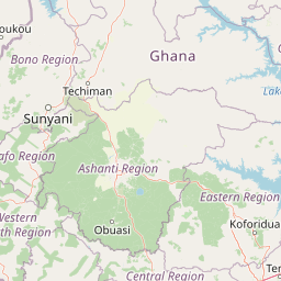
Map view of Bui National Park

Use this park location map to pinpoint Bui National Park in Ghana, understand its exact geographic position, and read its mapped placement within the surrounding landscape more clearly.

Pigeon | © OpenStreetMap contributors

Location context for Bui National Park

Bono RegionSavannah Region
Park atlas

Map the regional protected landscapes and compare national park geography within Ghana.

Discover More National Parks and Protected Areas Surrounding Bui National Park, Ghana

After exploring Bui National Park, browse other national parks and protected areas across Ghana, including reserves shaped by major rivers and diverse savanna ecosystems. Comparing these distinct protected landscapes reveals the broader conservation geography of West Africa, offering valuable insights into regional biodiversity and terrain.
Wildlife reserveBono East Region
About 96 km away#1 closest

Southeast

Boabeng-Fiema Monkey Sanctuary: Geographic Boundaries and Wildlife Reserve Context

Community-protected forest landscapes in Ghana

Boabeng-Fiema Monkey Sanctuary represents a rare community-based wildlife reserve located in central Ghana. Spanning 4.4 square kilometers between the villages of Boabeng and Fiema, the forest provides essential habitat for primate populations protected by generations of cultural tradition. This detail page offers geographic context, map exploration of the forest reserve, and insight into the unique intersection of woodland ecosystems and community-enforced conservation in the Bono East Region.

Area
4.4 km²
Established
1970
Relief
Lowland
Climate
Tropical
Watercolor illustration of a landscape with green fields, trees, and a body of water
National parkIvory Coast
About 100 km away#2 closest

Northwest

Comoé National Park: Geographic and Environmental Overview of the Ivory Coast Reserve

Mapping the transitions of West Africa's largest protected savanna ecosystem.

Comoé National Park serves as an ecological crossroads in north-eastern Ivory Coast, protecting 11,500 square kilometers of diverse terrain. The park hosts an extraordinary gradient of habitats, from dense gallery forests hugging the 230 kilometer stretch of the Comoé River to open, dry Sudanian savannas. Its geological foundation, featuring dramatic granite inselbergs and wide plains, supports a highly complex network of life, making it a cornerstone for understanding West African regional conservation and landscape ecology.

Area
11,500 km²
Established
1983
IUCN
II
Relief
Lowland
National parkIvory Coast
About 100 km away#3 closest

Northwest

Comoé National Park: Geographic Overview and Protected Landscape Analysis

Mapping the savanna and river corridors of Ivory Coast

Comoé National Park spans the northeastern reaches of Ivory Coast, providing a crucial protected space for West Sudanian savanna and gallery forests. This large-scale reserve is characterized by the hydrological influence of the Comoé River, which carves through the undulating plains to create seasonal floodplains and dense riverine corridors that serve as essential habitat for regional wildlife populations.

Area
11,491.5 km²
Established
1968
IUCN
II
Relief
Upland
National parkSavannah Region
About 102 km away#4 closest

North

Mole National Park: A Premier Protected Landscape in Ghana's Savannah Region

Explore mapped boundaries and Guinea savannah ecosystems.

Mole National Park represents a significant protected landscape within Ghana's Savannah Region, serving as the country's largest national park and a crucial conservation area for West African wildlife. The park's geography is defined by extensive Guinea savannah, characterized by grasslands with scattered woodlands and a prominent escarpment along its southern edge. Its vast expanse offers a unique opportunity to study mapped park boundaries and understand the ecosystem's role in regional conservation efforts. Discover the unique landscape context and protected area identity of this major West African wildlife refuge.

Area
4,840 km²
Established
1958
IUCN
II
Visitors
17.8K annual
Wildlife reserveUpper West Region
About 165 km away#5 closest

North

Wechiau Community Hippo Sanctuary: Protected River Landscapes and Savanna Wildlife Reserve

Upper West Region, Ghana: Riverine ecology and community-managed boundaries

Wechiau Community Hippo Sanctuary encompasses a protected stretch of the Black Volta, providing essential habitat for hippopotamuses in northwestern Ghana. This wildlife reserve features a diverse landscape of riverine forests, sandbanks, and savanna trails. The sanctuary demonstrates how local traditional governance maintains critical natural terrain while fostering an integrated cultural and ecological landscape.

Established
1999
Relief
Lowland
Scope
Terrestrial
Water
Major water bodies
Wildlife reserveGhana
About 194 km away#6 closest

Southeast

Bomfobiri Wildlife Sanctuary: Mapped Geography and Protected Landscapes in Central Ghana

A diverse habitat mosaic featuring forests, savanna, and waterfalls.

Bomfobiri Wildlife Sanctuary offers a compressed look at Ghana's natural diversity, where riverine corridors transition into open savanna. The protected area is recognized for its combination of dense forest, varied geological rock formations, and significant natural landmarks like the Lion Stone and local waterfalls, providing a clear perspective on the region's complex physical geography.

Area
53 km²
Established
1975
Wildlife reserveAshanti Region
About 211 km away#7 closest

Southeast

Bobiri Forest Reserve and Butterfly Sanctuary: Mapped Wildlife Reserve and Forest Geography

Ashanti Region protected landscape and butterfly habitat

Focusing on its status as a dedicated butterfly sanctuary, this protected forest reserve in Ghana offers a clear window into semi-deciduous ecology. Covering 54 square kilometers, the site is recognized for high insect biodiversity and its unique position as both an active research area and a managed wildlife reserve near the village of Kubease.

Area
54.65 km²
Established
1939
Relief
Upland
Climate
Tropical
Wildlife reserveUpper West Region
About 246 km away#8 closest

North

Gbele Resource Centre Wildlife Reserve: A Regional Atlas of Protected Savanna Landscapes

Mapped geography and protected woodland in Ghana

Gbele Resource Centre represents one of the most substantial protected savanna landscapes in northwestern Ghana, spanning over 500 square kilometres of Sudano-Sahelian woodland. The terrain is defined by the seasonal Kulpawn River and a distinct composition of African baobab and sycamore fig trees, which together anchor an important ecological corridor. This reserve provides a vital opportunity to map and understand the conservation geography and avian diversity that distinguish the Upper West Region from other parts of the country.

Area
565 km²
Relief
Lowland
Scope
Terrestrial
Water
Minor water

Common questions about visiting, size, designation, and location context for Bui National Park

Bui National Park FAQs for park facts, access, geography, and protected area context

Find quick answers about Bui National Park, including protected-area facts, park geography, trail and visitor context, and how the park fits into its surrounding country and regional landscape.
MoriAtlas Explorer

Continue Your Protected Areas Search Across the Global Atlas

Deepen your exploration by continuing the structured search for national parks and protected areas worldwide. Utilize the comprehensive filtering capabilities to compare different conservation landscapes and refine your understanding of global park geography. Discover more about the distribution and characteristics of protected natural areas.

Global natural geography