

Mori Atlas logo
Wildlife reserveCalauit Safari Park

A hybrid sanctuary blending open savannah habitat with tropical forest and coastal mangrove systems in the Calamian Islands.

Calauit Safari Park Wildlife Reserve: Protected Island Landscapes and Biodiversity in the Mimaropa Region

Calauit Safari Park occupies roughly 3,700 hectares on Calauit Island, serving as a distinct protected landscape within the Mimaropa region of the Philippines. The reserve is recognized for its unusual ecological mix, hosting both translocated African wildlife and native endemic species such as the Calamian deer and Philippine crocodile. This hybrid habitat features varied terrain ranging from open grasslands to forested hills, offering a unique look at island conservation and the recovery of local biodiversity.

island sanctuarywildlife safariAfrican ungulatesendemic Philippine wildlifeconservation successCalamian Islands

Calauit Safari Park

Wildlife reserve

Park overview

Structured park overview, official facts, and landscape profile for Calauit Safari Park

Calauit Safari Park park facts, protected area profile, and essential visitor context

Review the core facts for Calauit Safari Park, including designation, size, terrain, visitor scale, habitats, and operating context in one park-focused overview.

About Calauit Safari Park

Calauit Safari Park occupies the entirety of Calauit Island, a roughly 3,700-hectare landmass in the Calamian Islands chain off the western coast of Palawan. The park's identity is rooted in a paradoxical origin: it began as a personal game reserve for imported African wildlife but evolved into a sanctuary for some of the Philippines' most threatened native species.

The African animals, including giraffes, zebras, elands, impalas, waterbucks, topis, bushbucks, and Thomson's gazelles, were brought to the island between 1976 and 1977 from East Africa. The climate was selected to resemble Kenya, though the vegetation differed: the island's bamboo forests were cleared to make way for more open savannah-like terrain. Over the following decades, several of these antelope species disappeared due to habitat mismatch, disease, or poaching, leaving only giraffes and zebras as survivors of the original translocation program.

Starting in the 1980s, local conservation officials expanded the park's mission to include the protection of endemic Palawan and Calamian wildlife. The most dramatic success has been the recovery of the Calamian deer, which grew from about 25 individuals to more than 1,200 by 2016. The park now also shelters Palawan bearded pigs, Philippine crocodiles, porcupines, binturongs, and mouse-deer in dedicated conservation and breeding programs. Surrounding marine areas include recovering coral reefs, mangroves, and habitat for dugongs and sea turtles.

The park's human history adds another dimension. Before its establishment, Tagbanwa indigenous families lived on the island; their displacement and later recognition of ancestral land claims are central to contemporary discussions about the park. Today Calauit Safari Park operates as an eco-tourism destination managed by the Provincial Government of Palawan.

Quick facts and research context for Calauit Safari Park

Calauit Safari Park lies on Calauit Island in the Calamian Islands, off the coast of Palawan in the Mimaropa region of the Philippines. The island itself covers approximately 3,700 hectares and was declared a game preserve and wildlife sanctuary under Presidential Proclamation No. 1578 on August 31, 1976. The park combined an unusual mix of imported African ungulates and indigenous Philippine wildlife under a single protected-area framework.

Originally managed by a private conservation organization, the park's administration was transferred to the Provincial Government of Palawan in 2008, and it now operates as an eco-tourism attraction. Beyond the terrestrial animals, the surrounding marine environment includes recovered coral reefs, mangroves, and habitats for dugongs, sea turtles, and giant clams.

Protection and recognition

Examine the documented designation history and mixed protection scope of Calauit Safari Park.

Calauit Safari Park Protection Status and International Recognition Record

Calauit Safari Park maintains a documented protection scope and designation history established in 2008 without imported international recognition sources. Review structured administrative facts covering management scope and protected area records for this reserve.

Protection details

Protection scope
Mixed
Designated year
2008
Transboundary protection
No
Park context

Deeper park guide and search-rich context for Calauit Safari Park

Calauit Safari Park history, landscape, wildlife, and travel context

Explore Calauit Safari Park through its history, landscape character, ecosystems, wildlife, conservation priorities, cultural context, and seasonal travel timing in a structured park guide built for atlas discovery and search intent.

Why Calauit Safari Park stands out

Calauit Safari Park is best known for being one of the few places in Asia where African giraffes and zebras live in the wild outside their native continent. The sight of reticulated giraffes and Grevy's zebras grazing in a tropical Philippine island setting makes it a globally unusual wildlife destination. Equally significant is the park's conservation work for endemic species such as the Calamian deer, which recovered from near-extinction to over a thousand individuals, and the Philippine crocodile, one of the country's most critically endangered reptiles. The combination of African and Philippine fauna within one protected island ecosystem defines the park's distinctive identity.
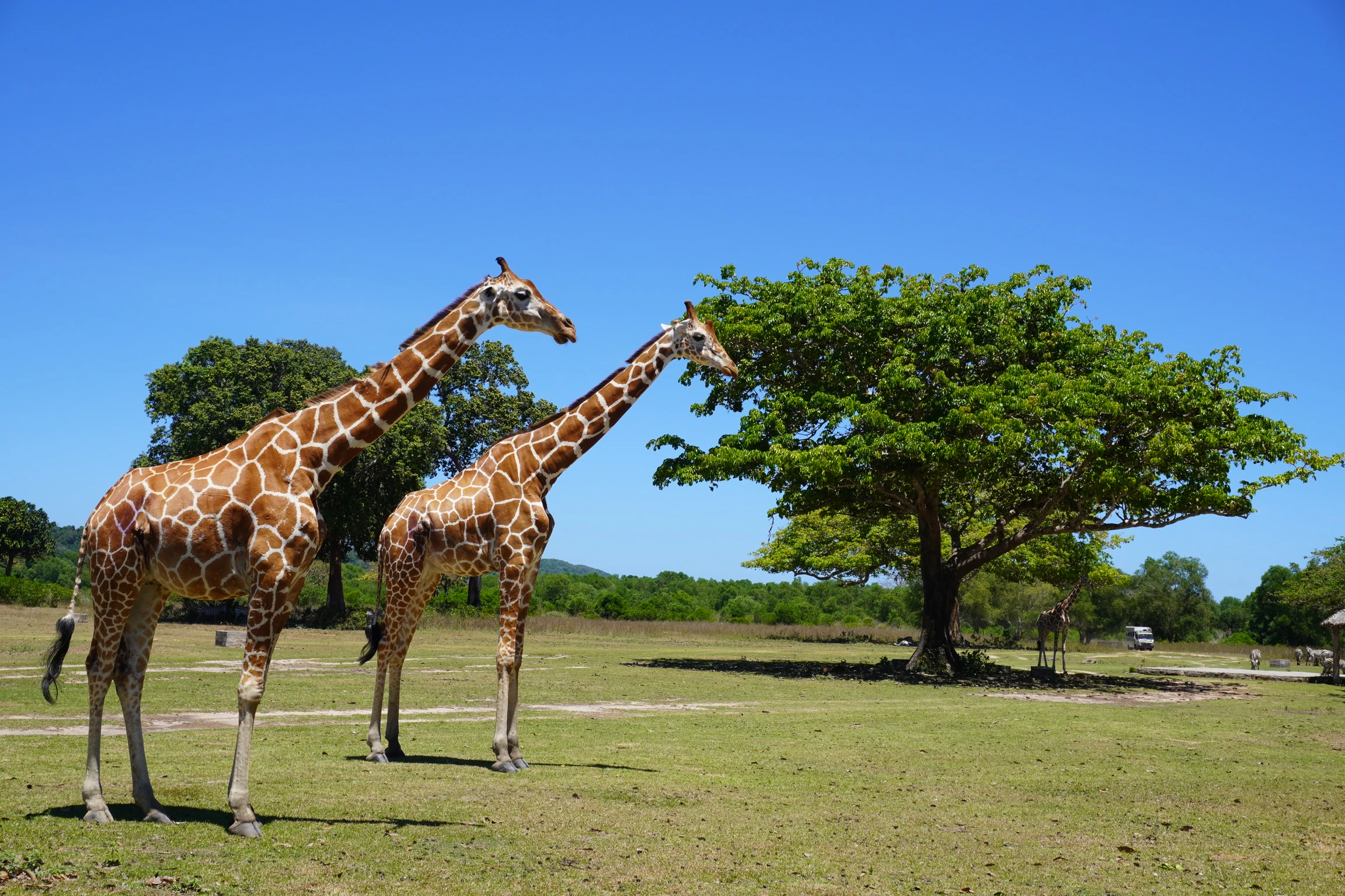
Calauit Safari Park
A wildlife sanctuary located in the Philippines.

Calauit Safari Park history and protected-area timeline

Calauit Safari Park was established under Presidential Proclamation No. 1578 on August 31, 1976, when President Ferdinand Marcos declared Calauit Island a game preserve and wildlife sanctuary. Marcos had approached British wildlife entrepreneur Tony Parkinson at the margins of the 1976 UNCTAD conference in Nairobi, hiring him to assemble and transport large African mammals to a Philippine island.

Before the park opened, an estimated 254 indigenous Tagbanwa families were evicted from Calauit and relocated to Halsey Island, a former leper colony. The relocation was carried out under martial law and remains a deeply contested chapter of the park's origin. Between May 1976 and August 1977, 104 African animals from eight species were translocated, arriving aboard the ship MV Salvador on March 4, 1977.

After the 1986 EDSA Revolution that ended the Marcos regime, the park became a symbol of government excess, and locals nicknamed it "Bongbong's Safari Park" after the president's son. In the same period, local officials redirected the park's mission toward conserving indigenous species, beginning what became its most enduring conservation legacy.

In 2008, Executive Order No. 722 transferred administration of the sanctuary to the Provincial Government of Palawan, and the park was rebranded as Calauit Safari Park. In 2010, the Philippine government formally recognized the Tagbanwa's ancestral land claims, issuing them a property title for the island and surrounding waters. Today the park is administered as both a conservation area and a tourism attraction.

Calauit Safari Park landscape and geographic character

Calauit Island is a roughly 3,700-hectare landmass in the Calamian Islands, characterized by a mix of tropical forest, cleared grasslands, mangrove-lined shores, and coastal terrain. The island's original vegetation included bamboo forests, which were cleared with tractors before African animals arrived to create more open, savannah-like habitat.

The terrain offered enough variety to support both introduced ungulates and native wildlife, with forest patches providing shade and cover for shy species such as porcupines and binturongs. The coastline includes mangrove systems and adjacent coral reefs that were once damaged by destructive fishing but have since shown significant recovery.

The island's physical isolation in the Calamian chain, surrounded by waters rich in marine biodiversity, contributes to its distinct ecological character. Inland hills and forested zones alternate with open grazing areas, creating a hybrid landscape that blends tropical island ecology with the open spaces originally designed for African herbivores.
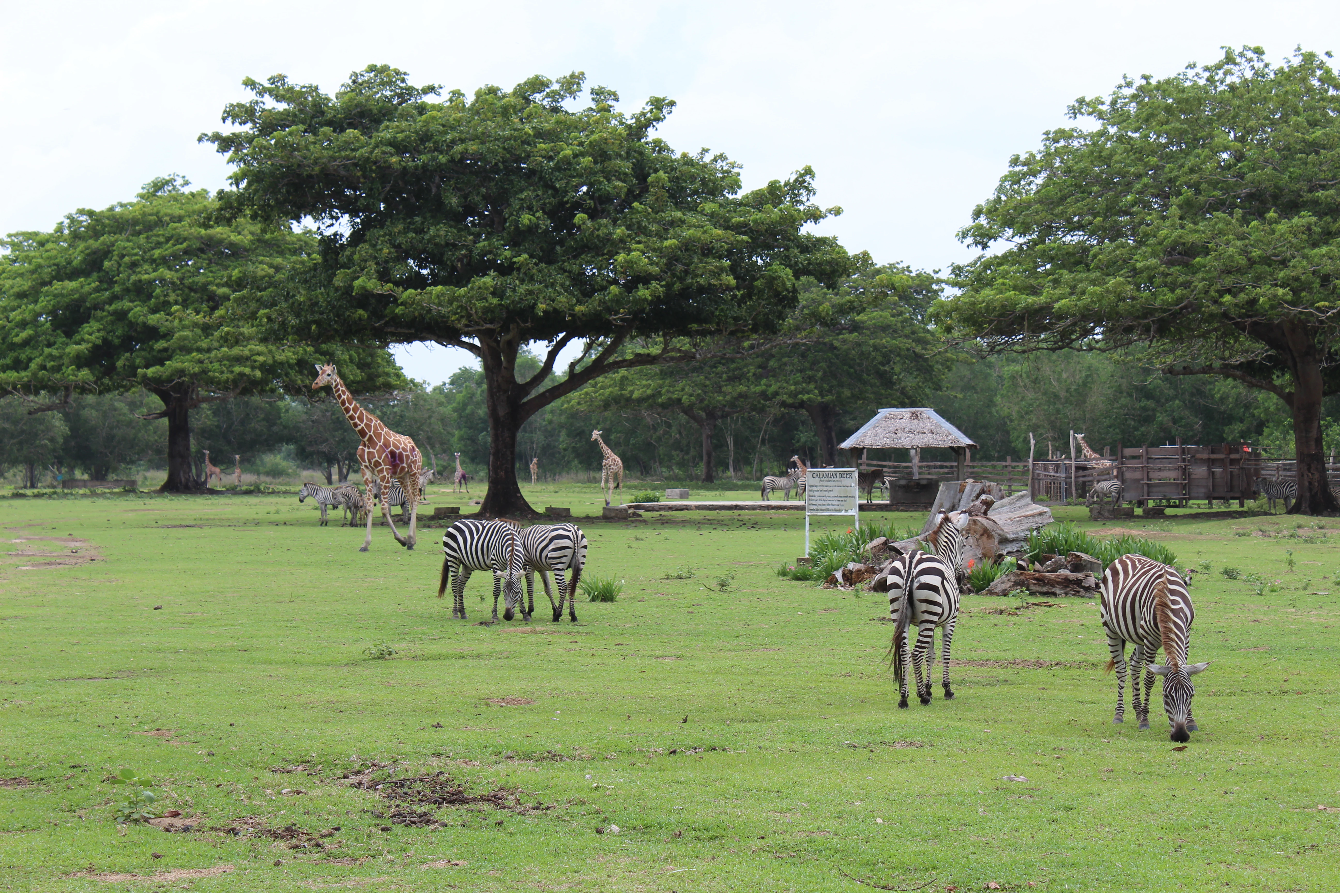
Calauit Safari Park view
Geographic coordinates of Calauit Safari Park: 12.2778 N, 119.8821 E

Calauit Safari Park ecosystems, habitats, and plant life

The ecological character of Calauit Safari Park blends introduced African savannah habitat with tropical island forest and coastal ecosystems. The cleared grasslands once designed for giraffes and antelopes now coexist with native Calamian vegetation, bamboo remnants, and regenerating forest patches that shelter endemic wildlife.

Wetlands and mangrove systems fringe the island, linking terrestrial habitats to marine environments that support dugongs, sea turtles, and giant clams. Recovery of the surrounding coral reefs has created renewed breeding grounds for fish and crustaceans, extending the park's ecological significance well beyond its ungulate populations.

The dual identity of the park, which is half managed savannah and half recovering tropical island ecosystem, makes it ecologically unusual. Conservation work focuses both on sustaining the African remnant populations and on restoring habitat for native Philippine species that had been pushed to the brink by deforestation and hunting.

Calauit Safari Park wildlife and species highlights

The wildlife of Calauit Safari Park is defined by its unusual mix of African and Philippine species. As of recent surveys, 18 reticulated giraffes and 27 Grevy's zebras survive as descendants of the original 1977 translocation. These populations face challenges from inbreeding and the absence of a full-time veterinarian, but they remain the park's most iconic residents.

The local conservation program has supported the recovery of several endemic species. The Calamian deer, once reduced to around 25 individuals, now numbers between 1,200 and 1,300 and has been downlisted from critically endangered to endangered by the IUCN. The park also maintains breeding and conservation efforts for the Philippine crocodile, Palawan bearded pig, Philippine porcupine, binturong, and Philippine mouse-deer.

Other native wildlife recorded on the island includes Palawan peacock pheasants, wildcats, scaly anteaters, pythons, and sea eagles. The surrounding waters host dugongs, sea turtles, and giant clams, while recovering coral reefs support diverse fish and crustacean populations.

Calauit Safari Park conservation status and protection priorities

Calauit Safari Park carries significant conservation importance for both its introduced African ungulates and, more substantially, for native Philippine species. The park's most measurable conservation success is the recovery of the Calamian deer, which grew from a handful of individuals to a thriving population of over 1,200, prompting an IUCN downlisting from critically endangered to endangered.

Breeding and care programs within the park support the critically endangered Philippine crocodile, the vulnerable Palawan bearded pig, the Philippine porcupine, and other endemic species. These efforts have positioned the park as an important reserve for Palawan's threatened fauna.

At a broader scale, conservation work extends to marine and forest habitats surrounding the terrestrial reserve. Recovery of coral reefs, protection of mangrove systems, and stewardship of ancestral waters contribute to ecosystem-level conservation that goes beyond the ungulate-focused origins of the sanctuary.

Calauit Safari Park cultural meaning and human context

The cultural dimension of Calauit Safari Park is inseparable from the experience of the Tagbanwa, the indigenous inhabitants of the Calamian Islands. Before the park's creation, Tagbanwa families lived on Calauit Island and relied on its land and forests. Their displacement to Halsey Island during the Marcos era remains a deeply consequential episode in the park's history.

In 2010, the National Commission on Indigenous Peoples formally recognized Tagbanwa ancestral domain rights, granting the community a property title for Calauit Island and 50,000 hectares of surrounding waters. This recognition reframed the park from a purely state-managed reserve into a landscape shared between conservation aims and indigenous heritage.

The park's modern identity as an eco-tourism destination, combined with ongoing dialogue about Tagbanwa land claims, gives it a layered cultural significance that extends beyond wildlife conservation.

Top sights and standout views in Calauit Safari Park

Calauit Safari Park offers the rare experience of observing African giraffes and Grevy's zebras in a tropical Philippine island setting, a legacy of the park's unusual 1970s origins.

The park is equally notable for its conservation successes with endemic species, especially the dramatic recovery of the Calamian deer from near-extinction to over a thousand individuals. Recovery of marine ecosystems, Tagbanwa ancestral recognition, and an evolving model of co-managed ecotourism round out the park's most distinctive qualities.

Best time to visit Calauit Safari Park

Calauit Safari Park sits in a tropical climate with warm temperatures year-round. The dry season, generally from late November through May, typically offers calmer seas for boat travel to Calauit Island from Busuanga and more predictable conditions for wildlife viewing in open areas. The wet season can bring heavier rainfall, though the park operates throughout the year.

Wildlife observation tends to be more reliable in the cooler and drier months, when animals concentrate near water sources and grazing areas. Travelers focused on the African giraffe and zebra populations often find the dry months most comfortable for extended time outdoors.
Monthly climate preview

Long-term representative point measurements tracking temperature and precipitation rhythm

Calauit Safari Park Climate Normals and Annual Weather by Month

Calauit Safari Park exhibits consistent multi-year temperature ranges alongside distinct shifts in monthly precipitation from minor dry-season totals to heavier wet-period averages. Examining the complete twelve-month climate profile reveals the full spectrum of measured averages recorded across the representative coordinate.
Annual mean28 °C
27 °C29 °C
Jan27°
Feb27°
Mar28°
Apr29°
May29°
Jun29°
Jul28°
Aug28°
Sep28°
Oct28°
Nov29°
Dec28°
Warmest month
May

29.3 °C

Coolest month
February

27.4 °C

Wettest month
July

16 mm/day

Driest month
February

0.8 mm/day

Park location guide

Geography guide, regional context, and park location map for Calauit Safari Park

Calauit Safari Park park geography, regions, and map view in Philippines

Understand where Calauit Safari Park sits in Philippines through a broader geographic reading of the surrounding landscape, nearby location context, and its mapped position within the national park landscape.

How Calauit Safari Park fits into Philippines

The Philippines, officially the Republic of the Philippines, is an archipelagic nation in Southeast Asia comprising approximately 7,641 islands categorized into three main geographical divisions: Luzon, Visayas, and Mindanao. Located in the western Pacific Ocean, it shares maritime borders with Taiwan, Japan, Palau, Indonesia, Malaysia, Vietnam, and China. Manila serves as the capital city, while Quezon City is the most populated city, both within Metro Manila.

Wider geography shaping Calauit Safari Park in Philippines

The Philippines is an archipelagic nation in Southeast Asia, positioned in the western Pacific Ocean. Its islands are bounded by the South China Sea to the west, Philippine Sea to the east, and Celebes Sea to the south. The country shares maritime borders with Taiwan to the north, Japan to the northeast, Palau to the east and southeast, Indonesia to the south, Malaysia to the southwest, Vietnam to the west, and China to the northwest.

Map view of Calauit Safari Park

Use this park location map to pinpoint Calauit Safari Park in Philippines, understand its exact geographic position, and read its mapped placement within the surrounding landscape more clearly.

Pigeon | © OpenStreetMap contributors

Location context for Calauit Safari Park

Mimaropa

Explore national park imagery capturing savannah terrain, tropical forests, and coastal habitats.

Calauit Safari Park Photos and Landscapes: Visualizing the Island Sanctuary

Visual documentation of Calauit Safari Park reveals the distinctive terrain where African ungulates graze alongside endemic Philippine wildlife. Examining these protected area photographs provides clear insight into the hybrid island environment, mangrove shores, and open grasslands.

Calauit Safari Park

Calauit Safari Park in Coron

Calauit Safari Park view

Park atlas

Compare nearby island sanctuaries, coastal reserves, and regional protected landscapes.

Other Parks Like Calauit Safari Park and Protected Areas in the Surrounding Region

Browsing other parks near Calauit Safari Park reveals connected island ecosystems, coastal mangroves, and diverse regional protected landscapes across the western Philippines. Comparing these neighboring wildlife sanctuaries provides a broader geographic perspective on tropical conservation and island biodiversity.
Protected areaPalawan
About 54 km away#1 closest

Southeast

Coron Island Protected Area: Mapping the Limestone Karst and Inland Lakes of Palawan

Karst terrain and marine protected landscapes in the Calamian Islands

Discover the geographic structure of Coron Island Protected Area, where towering limestone ridges and cliffs surround secluded freshwater lakes. The territory preserves a diverse ecosystem of coastal mangroves and marine waters within the Palawan province, illustrating a unique intersection of geological history and traditional indigenous stewardship.

Area
222.48 km²
Established
1998
Relief
Upland
Scope
Mixed
Marine protected areaPhilippines
About 73 km away#2 closest

Northeast

Apo Reef Marine Natural Park: Protected Coral Reef Atlas and Marine Geography

Marine protected area in the Mindoro Strait, Philippines

Apo Reef Marine Natural Park serves as a high-priority conservation landscape featuring two massive triangular coral banks and steep underwater drop-offs. This site provides a critical case study in marine geomorphology, characterized by its deep submarine trenches and unique atoll-like structure within the broader Philippine archipelagic geography.

Area
274.69 km²
Established
1996
Scope
Marine
Water
Water-dominated
Protected landscapePalawan
About 131 km away#3 closest

Southwest

El Nido-Taytay Managed Resource Protected Area: A Coastal Karst and Marine Landscape Atlas

Mapping the terrestrial and marine boundaries of northern Palawan.

An authoritative overview of the El Nido-Taytay Managed Resource Protected Area, detailing its extensive karst limestone islands, hidden lagoons, and diverse coastal ecosystems. This record maps the intersection of terrestrial forests and marine habitats that span the municipalities of El Nido and Taytay, providing a clear geographic context for this significant Philippine protected landscape.

Area
923.34 km²
Established
1998
Wildlife reserveOccidental Mindoro
About 142 km away#4 closest

North

Mount Calavite Wildlife Sanctuary: Regional Geography and Protected Habitat Mapping

A historic wildlife reserve in Occidental Mindoro

Located in northwestern Occidental Mindoro, Mount Calavite Wildlife Sanctuary preserves a distinct vertical sequence of habitats, from remnant rainforest to high-elevation grasslands. The area is defined by ancient metamorphic geology and serves as a vital stronghold for range-restricted birds and the endangered Tamaraw. This atlas entry provides structured insight into the sanctuary's boundaries, terrain, and its enduring role in Philippine conservation geography.

Area
181.5 km²
Established
1920
Relief
Mountain
Scope
Terrestrial
National parkMindoro
About 158 km away#5 closest

Northeast

Mounts Iglit, Baco National Park: Philippines Protected Landscape and Geographic Identity

Explore Mindoro's significant national park and its mapped natural terrain.

Delve into Mounts Iglit, Baco National Park, a protected national park located on the island of Mindoro. This entry offers a detailed geographic perspective, focusing on its mapped boundaries and its role within the archipelago's conservation landscape. Understand the park's specific regional geography and its identity as a distinct protected area.

Relief
Mountain
Scope
Terrestrial
National parkPhilippines
About 168 km away#6 closest

Northeast

Lake Naujan National Park: An Atlas of Volcanic Lakes and Wetland Geography

Mapped protected landscapes in the Philippines

Lake Naujan National Park occupies a unique geographic position on Mindoro Island, centering on a vast volcanic freshwater lake. The protected area integrates diverse terrain ranging from aquatic wetland zones and thermal springs to lowland forests and managed agricultural buffers, providing an essential study in human-modified conservation landscapes.

Protected landscapePalawan
About 174 km away#7 closest

South

Malampaya Sound Protected Landscape/Seascape: Geographic Atlas and Coastal Park Boundaries

A combined marine and terrestrial protected area in Palawan, Philippines

Gain insights into the geographic composition of Malampaya Sound Protected Landscape/Seascape. This expansive site on Palawan island encompasses sheltered bays, island chains, and mangrove-fringed shorelines. Examine the structural balance between brackish-water ecosystems, essential tidal flats, and local fishing barangays within a single managed maritime reserve.

Area
2,015.66 km²
Established
2000
Relief
Lowland
Scope
Mixed
National parkPhilippines
About 183 km away#8 closest

Northeast

Naujan Lake National Park: Philippines National Park Atlas and Protected Landscape

Explore its mapped boundaries and regional geographic context.

Naujan Lake National Park offers a focused exploration of a distinct protected landscape within the Philippines. This page details the park's specific geographic footprint and its characteristics as a national park. Understand its place within the archipelago's broader geography, providing a valuable entry point for atlas-based discovery of protected natural areas and their mapped extents across Southeast Asia.

Scope
Terrestrial
Water
Water-dominated

Common questions about visiting, size, designation, and location context for Calauit Safari Park

Calauit Safari Park FAQs for park facts, access, geography, and protected area context

Find quick answers about Calauit Safari Park, including protected-area facts, park geography, trail and visitor context, and how the park fits into its surrounding country and regional landscape.
MoriAtlas Explorer

Continue Your Protected Areas Search Across the Global Atlas

Deepen your exploration by continuing the structured search for national parks and protected areas worldwide. Utilize the comprehensive filtering capabilities to compare different conservation landscapes and refine your understanding of global park geography. Discover more about the distribution and characteristics of protected natural areas.

Global natural geography