
Natural springs
Park geography
A structured analysis of landscape, terrain, and regional geography in Utah
Canyonlands National Park: Detailed Geographic Profile, Mapped Boundaries, and Natural Features
Review the physical dimensions and environmental characteristics of Canyonlands National Park. This geography profile covers the 1,366 square kilometer expanse, including major natural features like canyons, plateaus, and riverine habitats that define the arid terrain of this Utah landscape.
Related tags
Desert LandscapeCanyon ParkColorado PlateauGeological FormationRiver Confluence
Vast desert canyon landscape carved by the Colorado and Green Rivers
Canyonlands National Park
Canyonlands National Park is a United States national park located in southeastern Utah near the town of Moab. The park preserves a colorful landscape eroded into numerous canyons, mesas, and buttes by the Colorado River, the Green River, and their respective tributaries. Established on September 12, 1964, when President Lyndon B. Johnson signed legislation creating the park, Canyonlands covers over 337,000 acres of high desert terrain. The park is divided into four distinct districts: Island in the Sky, the Needles, the Maze, and the combined rivers area. Each district offers a different character while sharing a primitive desert atmosphere that author Edward Abbey described as "the most weird, wonderful, magical place on earth—there is nothing else like it anywhere." The convergence of the Colorado and Green Rivers at the heart of the park creates one of the most dramatic river confluences in North America.
- Location
- United States of America
- Park type
- National park
- Established
- 1964
- Area
- 1,366.2 km²
Location overview
National park distribution within Utah and the United States
Geographic Setting and Location of Canyonlands National Park
Canyonlands National Park is situated within the state of Utah in the United States of America. Geographic records confirm its status as an inland protected area situated entirely within a single country.
- Countries
- United States of America
- Regions
- Utah
- Primary location
- Utah
- Geographic setting
- Inland
Boundary and coordinates
Exploring the 1,366 square kilometer coordinate extent and park limits
Boundary Map and Spatial Limits of Canyonlands National Park
Interactive boundary geometry provides essential spatial context for Canyonlands National Park. Accompanying dataset metrics outline calculated area, perimeter, and coordinate spans.
- Boundary area
- 1,352.7 km²
- Boundary perimeter
- 277.6 km
- Northernmost point
- 38.5081° N
- Southernmost point
- 37.9599° N
- Easternmost point
- 109.6638° W
- Westernmost point
- 110.2352° W
- Geographic centre
- 38.2451° N, 109.8801° W
- North–south span
- 60.8 km
- East–west span
- 50 km
Terrain and natural features
Explore recorded arches, springs, and canyons within the protected landscape
Canyonlands National Park Terrain and Named Natural Features
Canyonlands National Park features a mixed relief classification alongside recorded natural landmarks like Millard Canyon and Chesler Canyon. Linked feature cards supply official names, structural types, and spatial relationships for all documented features.
Selected named natural features
Streams
Millard Canyon
Natural arches
Anchor Arch 1
Viewpoints
Shafer Canyon Overlook
Natural arches
Handhold Arch
Streams
Upheaval Canyon
Environmental setting
Arid climate zones, sparse forest cover, and mixed relief across desert habitats
Canyonlands National Park Environmental Setting and Physical Geography Classifications
Recorded landscape features and habitat types provide complementary ways to read the physical setting of Canyonlands National Park. Connected categories link directly to relevant atlas destinations for regional environmental comparison.
- Relief
- Mixed relief
- Climate
- Arid
- Water
- Major water bodies
- Forest cover
- Sparse forest
- Seasonality
- Seasonal
Landscape features
Canyon · Plateau · Hills · Rivers · Cliffs · Grassland · Dunes
Habitat types
Desert habitat · Grassland · Shrubland · Riverine habitat
Park atlas
Compare the regional spread of protected areas, tracing diverse canyon and desert landscapes of the Colorado Plateau.
Explore National Parks and Protected Areas Adjacent to Canyonlands National Park, Utah
Explore a curated selection of national parks and protected areas situated within the high desert terrain and dramatic canyon systems surrounding Canyonlands National Park. Compare their distinct geological formations, river carved landscapes, and unique wilderness characters to deepen your understanding of the broader Colorado Plateau conservation geography.
Protected landscapeUnited States of America
Park boundaries overlap#1 closest
Southwest

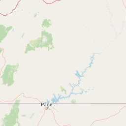
Glen Canyon National Recreation Area: Protected Landscape and High Desert Geography Map
Colorado Plateau canyons, sandstone strata, and reservoir environments
Explore the geological architecture of Glen Canyon National Recreation Area, a vast federal protected landscape. The area showcases towering Navajo Sandstone cliffs, deep blue reservoir arms, and remote backcountry canyons that exemplify the distinct high desert terrain of the Colorado Plateau in the United States.
- Area
- 5,075.23 km²
- Established
- 1972
- Visitors
- 5.2M annual
- Relief
- Upland

Protected landscapeUtah
3.2 km away#2 closest
Northwest
Manti, La Sal National Forest: Geographic Overview of Utah's Mountain and Canyon Landscapes
Mapped protected forest boundaries across the Colorado Plateau
Spanning over one million acres, Manti, La Sal National Forest defines a critical segment of Utah geography. This protected landscape encompasses diverse terrain including subalpine mountains, aspen-rich uplands, and deep canyon networks. Use this atlas to examine the distinct environmental characteristics that separate the northern forested plateaus from the southern wilderness canyons.
- Area
- 5,143.09 km²
- Established
- 1950
- IUCN
- V
- Visitors
- 900K annual
National parkUtah
17 km away#3 closest
North
Arches National Park: Utah National Park Protected Landscape Exploration
Explore mapped terrain and geographic context.
Delve into the specifics of Arches National Park, a protected national park located in Utah. This atlas-focused entry provides detailed insight into the park's protected landscape features and geographic distribution. Understand the mapped park boundaries and the unique natural terrain that shapes this significant conservation area within the United States' broader regional geography.
- Area
- 310.31 km²
- Established
- 1971
- IUCN
- II
- Visitors
- 1.5M annual
Protected landscapeColorado
76 km away#4 closest
East
San Juan National Forest: Geographic Overview of a Major Southern Colorado Protected Landscape
Mapped terrain across the Southern San Juan Mountains
San Juan National Forest represents a massive protected landscape in western Colorado, defined by its rugged alpine peaks, dense conifer forests, and glacial valleys. This atlas entry details the forest boundary, its position along the Continental Divide, and the surrounding transition into the Colorado Plateau. It provides a structured look at the terrain that connects diverse ecosystems, from high-altitude tundra to expansive mesa country, within one of the largest national forests in the American West.
- Area
- 7,603.42 km²
- Established
- 1905
- Relief
- Mountain
- Climate
- Alpine
National parkUtah
78 km away#5 closest
West
Capitol Reef National Park: Utah National Park Protected Landscape and Geography
Explore Capitol Reef National Park's mapped terrain and boundaries.
Delve into the protected landscape and geographic identity of Capitol Reef National Park, a key national park in Utah. This resource provides detailed context on its mapped terrain and regional setting, supporting a structured understanding of protected areas for atlas exploration. Discover the specific geographic features and park boundaries that define this protected natural area.
- Area
- 978.95 km²
- Established
- 1971
- IUCN
- II
- Visitors
- 1.4M annual
Protected landscapeColorado
91 km away#6 closest
Northeast
Grand Mesa National Forest: A Comprehensive Atlas of Colorado High-Plateau Geography
Mapping the basalt-capped flat-top mountain terrain
Grand Mesa National Forest stands as a primary protected landscape within the Colorado Rockies, characterized by its signature basalt-capped plateau. This forest unit serves as a vital geographic landmark, offering unique insights into high-altitude mountain terrain, subalpine water systems, and historical forest conservation. Learn about the boundaries and physical landscape features that define this massive elevated tableland above the surrounding dry valleys.
- Area
- 1,402.46 km²
- Established
- 1892
- Relief
- Highland
- Climate
- Alpine
Wildlife reserveColorado
108 km away#7 closest
Northeast
Dominguez Canyon Wilderness: Protected Sandstone Canyons of the Uncompahgre Plateau
An expansive BLM wilderness area in western Colorado.
Dominguez Canyon Wilderness protects a diverse landscape of sandstone cliffs, benches, and deep drainage systems that descend from the Uncompahgre Plateau. The geography spans high-desert mesa tops and lush riparian canyons, offering a significant protected area within the Dominguez-Escalante National Conservation Area framework.
- Area
- 268.2 km²
- Established
- 2009
- IUCN
- Ib
- Relief
- Upland
National parkMontezuma County
124 km away#8 closest
Southeast
Mesa Verde National Park: Protected Landscape Atlas and Geographic Identity
Discover the mapped terrain and regional context of this national park.
Mesa Verde National Park serves as a critical protected landscape within Montezuma County, offering distinct insights into regional geography and mapped terrain. This entry details the park's identity as a National Park, emphasizing its geographic setting and providing a foundation for atlas-driven exploration. Understand the park's place within the broader landscape context and its significance as a mapped protected area, ideal for focused geographic study.
- Area
- 212.4 km²
- Established
- 1906
- IUCN
- II
- Visitors
- 463.1K annual
MoriAtlas Explorer
Continue Exploring Canyonlands National Park's Geographic and Mapped Landscape
Discover more about the protected landscape and regional geography of Canyonlands National Park. This destination offers a unique perspective on Utah's vast natural terrain and its mapped boundaries, ideal for understanding protected areas within a detailed geographic atlas. Uncover the specific environmental context that defines this significant national park.
Browse next
Global natural geography
Explore related park routes
Explore MoriAtlas Global ParksBrowse All MoriAtlas ParksGlobal Park Map DiscoveryMoriAtlas: Browse All CountriesBrowse All MoriAtlas ContinentsNational Park Environment AtlasGrand Canyon National Park AtlasYellowstone National Park AtlasYosemite National Park Atlas and GeographySerengeti National Park AtlasGalápagos National Park Protected LandscapeBanff National Park Geography and AtlasKruger National Park Atlas EntryUluṟu-Kata Tjuṯa National Park AtlasExplore Uluru-Kata Tjuta National Park GeographyPlitvice Lakes National Park AtlasFiordland National Park Protected LandscapeGreat Smoky Mountains National Park AtlasAfghanistan National Parks and Protected AreasAlbania National Parks and Protected AreasAlgeria National Parks and Protected AreasAmerican Samoa National Parks and Protected AreasAndorra National Parks and Protected AreasAngola National Parks and Protected AreasAntarctica National Parks and Protected AreasAntigua and Barbuda Park List