

Mori Atlas logo
Nature reserveCap Island Conservation Park

Exploring the granite and calcarenite island geography, seabird breeding sites, and marine mammal haul-outs.

Cap Island Conservation Park: A Protected Nature Reserve within the South Australia Coastal Atlas

Cap Island Conservation Park represents a compact, ecologically vital protected island located approximately 7.5 kilometres off the Eyre Peninsula. This nature reserve, characterized by its distinctive granite base and eroded calcarenite mantle, functions as a critical refuge for diverse seabird populations and pinnipeds. The island terrain, defined by steep overhanging margins and salt-tolerant shrubland, provides essential habitat within the broader marine landscape of the southern coast.

offshore islandseabird breedingmarine mammal haul-outgranite islandcalcarenitesalt-tolerant shrubland

Cap Island Conservation Park

Nature reserve

Park overview

Structured park overview, official facts, and landscape profile for Cap Island Conservation Park

Cap Island Conservation Park park facts, protected area profile, and essential visitor context

Review the core facts for Cap Island Conservation Park, including designation, size, terrain, visitor scale, habitats, and operating context in one park-focused overview.

About Cap Island Conservation Park

Cap Island Conservation Park is a compact offshore island reserve in South Australia, sitting about 7.5 kilometres west of the Eyre Peninsula coastline near Mount Misery. Though it occupies only a few hectares, it carries the kind of ecological importance typically associated with much larger reserves, because it safeguards both a seabird breeding area and the haul-out sites of two marine mammal species: the Australian sea lion and the New Zealand fur seal.

The island's natural structure has shaped nearly every aspect of the park's conservation value. A granite base is overlain by a calcarenite mantle, and the margins of the island are steeply overhanging, eroded, and exposed to constant wave action. This rugged surface is unattractive to human access, which has likely helped the island retain its wildlife significance, while creating exactly the kind of cliff, ledge, and crevice environments that seabirds rely on for nesting, and that marine mammals use for resting and breeding ashore.

The vegetation reflects this harsh marine setting. The dominant plant community is a low nitre bush shrubland, adapted to salt spray, thin soils, and nutrient inputs from guano and marine detritus. Together with other halophytic and succulent plants recorded on the island, this shrubland forms a sparse but ecologically characteristic cover that defines the island's terrestrial habitats.

The reserve's formal protection has been longstanding. The island was first proclaimed as a Fauna Conservation Reserve in 1967, and then gazetted under its current name in 1972, giving it decades of continuous legal protection as one of South Australia's strict nature reserves (IUCN Category Ia). The result is a small but well-protected piece of the Eyre Peninsula's offshore island network, where seabirds and pinnipeds remain the dominant wildlife feature.

Quick facts and research context for Cap Island Conservation Park

Cap Island Conservation Park lies off the west coast of the Eyre Peninsula in South Australia, near the small town of Elliston. It protects a single island, Cap Island, in a strict nature reserve classification (IUCN Category Ia), and is administered by the South Australian Department for Environment and Water.

The island itself is geologically distinctive, formed from a granite base overlain by a calcarenite mantle, with steeply eroded margins that give the feature its cap-like profile. The reserve was first proclaimed in 1967 as a Fauna Conservation Reserve and later re-gazetted as a conservation park in 1972, with seabird breeding habitat and marine mammal haul-out areas as its primary conservation targets.

Protection and recognition

Documented protection scope and established designation records for Cap Island Conservation Park

Cap Island Conservation Park Protection Status and Designation History

Cap Island Conservation Park maintains a mixed protection scope established through records dating back to 1972. Structured data compiles official designation history and management parameters without international recognition sources.

Protection details

Protection scope
Mixed
Designated year
1972
Transboundary protection
No
Park context

Deeper park guide and search-rich context for Cap Island Conservation Park

Cap Island Conservation Park history, landscape, wildlife, and travel context

Explore Cap Island Conservation Park through its history, landscape character, ecosystems, wildlife, conservation priorities, cultural context, and seasonal travel timing in a structured park guide built for atlas discovery and search intent.

Why Cap Island Conservation Park stands out

Cap Island Conservation Park is best known as a seabird breeding and marine mammal refuge on the western Eyre Peninsula. Its cliffs and ledges support breeding populations of seabirds and provide haul-out habitat for Australian sea lions and New Zealand fur seals, giving a small offshore granite island an outsized ecological role in the region. Its distinctive geological structure, a granite base with a calcarenite cap, also defines both the visual character of the island and the kind of exposed, erosion-prone habitats where the native shrubland clings to thin soils.

Cap Island Conservation Park history and protected-area timeline

Cap Island Conservation Park has a relatively short but clearly documented formal protection history. Matthew Flinders, during his charting voyage along the southern Australian coast, named the island on 16 February 1802, referencing its topography, geology, and its distinctive cap-like profile when seen from the sea.

For more than a century and a half after that naming, the island remained outside any formal reserve system. In 1967 it was proclaimed a Fauna Conservation Reserve under South Australian legislation, recognising its importance as a wildlife refuge. Five years later, in 1972, the area was gazetted as Cap Island Conservation Park under the state's conservation park framework, consolidating its protection status and clarifying its management mandate.

The park is now classified as an IUCN Category Ia protected area, meaning it is managed as a strict nature reserve with conservation given primacy over other land uses. This long-running formal protection reflects the consistent recognition of the island's ecological value for seabird breeding and marine mammal haul-out habitat.

Cap Island Conservation Park landscape and geographic character

The landscape of Cap Island Conservation Park is dominated by a single, small offshore island rather than a broad terrestrial expanse. The island sits roughly 7.5 kilometres from the Eyre Peninsula coastline, west of Mount Misery, placing it firmly within the cold-water marine environment of the southern Great Australian Bight region.

Geologically, the island consists of a granite base overlain by a calcarenite mantle, a combination that results in a distinctive cap-like profile, the very feature that earned it its name. The margins of the island are steeply overhanging and heavily eroded, indicating active marine influence through wave undercutting and weathering. This rugged, sculpted edge gives the island sharp transitions between rocky shoreline, exposed cliff faces, and the open water surrounding it.

There are no inland water bodies, dunes, ridges, or forested zones; the island's topography is essentially compressed into one small rocky landmass. Its visual character is austere and exposed, with low shrub cover clinging to the plateau and slopes, and rocky outcrops dominating wherever vegetation thins. The result is a landscape defined less by scale than by contrast between the calm inland vegetation patterns and the active, erosive coastal perimeter.

Cap Island Conservation Park ecosystems, habitats, and plant life

Cap Island Conservation Park's ecological character is defined by the interaction of an exposed granite-and-calcarenite island with persistent marine influence. Soils are thin, salt-laden, and heavily affected by seabird nutrient enrichment, while freshwater input is minimal. These conditions produce a tightly adapted, halophyte-dominated plant community, with nitre bush shrubland as the most characteristic formation.

A modest range of salt-tolerant and coastal-adapted plant species has been recorded, including sea celery, rounded noon-flower, Australian sea-heath, thorny lawrencia, common ice plant, and other succulents and chenopods typical of South Australian offshore islands. Together, these species form a sparse but distinctive vegetation layer across the limited land surface.

The island's role within the broader Eyre Peninsula ecosystem is primarily as offshore refuge and breeding habitat. Its isolation from the mainland limits terrestrial predator pressure, while its cliff and ledge environments provide the structural habitat features needed by both seabirds and pinnipeds. This combination of isolation, exposure, and specialised vegetation gives the park a clear ecological identity as a marine-linked island ecosystem rather than a mainland terrestrial reserve.

Cap Island Conservation Park wildlife and species highlights

The wildlife profile of Cap Island Conservation Park is dominated by its role as an offshore breeding and resting site, with two clear faunal emphases: seabirds and marine mammals.

For marine mammals, Cap Island provides haul-out habitat used by both the Australian sea lion and the New Zealand fur seal. The combination of steep rocky margins, sheltered ledges, and nearby open water makes the island a predictable location for these species to come ashore, rest, and for sea lions in particular to maintain breeding groups.

On land and along the cliff faces, at least nine bird species have been recorded breeding or visiting the island. These include silver gull, sooty oystercatcher, welcome swallow, rock parrot, white-faced storm-petrel, white-fronted tern, fairy tern, common starling, and crested tern. The mix of terns, storm-petrels, and rocky-shore specialists underlines the island's function as a seabird breeding area, while the presence of species such as the rock parrot reflects the distinctive calcarenite habitat that the island provides.

The general absence of large terrestrial mammals and the dominance of seabird and pinniped activity mean wildlife observation from any nearby vessel or vantage point tends to focus on the airspace over the island and on animals hauled out along its rocky shoreline.

Cap Island Conservation Park conservation status and protection priorities

Cap Island Conservation Park was formally established to conserve an area of recognised ecological value, and its long conservation history underlines its role within South Australia's protected-area system. Originally proclaimed as a Fauna Conservation Reserve in 1967 and later re-gazetted as a conservation park in 1972, the area has been under formal protection for decades and is now classified as an IUCN Category Ia strict nature reserve, the highest level of protection in the IUCN system.

The park's conservation value centres on its function as a seabird breeding area and on the haul-out habitat it provides for Australian sea lions and New Zealand fur seals. These two marine mammal species are of considerable conservation interest, and the island's protected status helps shield the haul-out sites from activities that might disturb breeding or resting animals nearby.

Although the park is extremely small in area, its offshore island character, combined with the limited accessibility of its steep rocky margins, gives the reserve a high degree of natural protection. By formally securing this small fragment of coastal habitat, the park contributes to the broader conservation of seabird populations and pinniped habitat along the western Eyre Peninsula, where exposed granite islands provide only limited, scattered breeding and haul-out opportunities.

Cap Island Conservation Park cultural meaning and human context

Cap Island carries a modest but real cultural footprint through its place in the European charting history of the southern Australian coast. The island was named by Matthew Flinders on 16 February 1802 during his coastal survey voyage, with the name drawn directly from the island's topography, geology, and distinctive cap-like silhouette when seen from the sea. This makes the park part of the small group of South Australian geographic features whose naming is directly linked to early European maritime exploration.

The island's alternative name, Gap Island, and its older historical name, Rocky Island, suggest a long history of local and seafaring reference, with different communities and observers recording the same feature under different terms. There is limited source material describing deeper indigenous or community-level cultural associations with the island specifically, so the documented cultural context remains primarily navigational, explorative, and naming-based rather than narrative.

Top sights and standout views in Cap Island Conservation Park

Cap Island Conservation Park's standout quality is the disproportionate ecological value packed into a very small land area: it is simultaneously a seabird breeding reserve, a marine mammal haul-out, and the protected habitat of a geologically distinctive granite-and-calcarenite island.

Its flinders-named, cap-shaped profile, steeply eroded rocky margins, and nitre bush shrub cover collectively form an unusually concentrated example of South Australia's offshore island ecology. The combination of formal IUCN Category Ia protection, multi-decade reserve status, and a tightly adapted community of seabirds and pinnipeds makes the reserve a compact but representative example of marine-island conservation on the Eyre Peninsula.

Best time to visit Cap Island Conservation Park

The park is a remote offshore reserve, and the few visitors who see it typically encounter it from a vessel or from elevated coastal lookouts along the Eyre Peninsula. Conditions for any such viewing are best when seas are calmer, visibility is higher, and seabird and marine mammal activity is most likely to be observed at haul-out and breeding sites.

The southern Australian coastal climate means conditions can be highly variable, with stronger winds and rougher seas common in the cooler months. In general, milder conditions improve both offshore access and the chance of calm water close to the island's haul-out sites, although the park should be regarded primarily as a conservation reserve rather than a routine visitor destination.
Monthly climate preview

Trace monthly average temperatures and precipitation cycles across the protected landscape

Cap Island Conservation Park Climate Normals and Annual Weather Patterns

Long-term data records reveal distinct seasonal temperature swings and shifting precipitation averages across the representative park coordinate. Examining the complete monthly climate profile provides deeper context for researchers analyzing regional environmental conditions.
Annual mean17 °C
13 °C20 °C
Jan20°
Feb20°
Mar19°
Apr18°
May16°
Jun14°
Jul13°
Aug13°
Sep14°
Oct16°
Nov17°
Dec19°
Warmest month
February

20.1 °C

Coolest month
July

13.5 °C

Wettest month
June

1.9 mm/day

Driest month
January

0.5 mm/day

Park location guide

Geography guide, regional context, and park location map for Cap Island Conservation Park

Cap Island Conservation Park park geography, regions, and map view in Australia

Understand where Cap Island Conservation Park sits in Australia through a broader geographic reading of the surrounding landscape, nearby location context, and its mapped position within the national park landscape.

How Cap Island Conservation Park fits into Australia

Australia is a constitutional monarchy and federal parliamentary democracy comprising six states and ten territories. With a population of nearly 28 million, it is one of the world's most urbanised countries, with most people concentrated on the eastern seaboard. The country has a high Human Development Index and is known for its cultural diversity, ancient Aboriginal heritage, and unique wildlife.

Wider geography shaping Cap Island Conservation Park in Australia

Australia occupies the entire Australian continent, the island of Tasmania, and numerous smaller islands. It is the world's flattest and driest inhabited continent, featuring vast deserts in the interior (the Outback), tropical rainforests along the eastern coast, and a coastline bordering the Indian and Pacific Oceans.

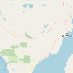
Map view of Cap Island Conservation Park

Use this park location map to pinpoint Cap Island Conservation Park in Australia, understand its exact geographic position, and read its mapped placement within the surrounding landscape more clearly.

Pigeon | © OpenStreetMap contributors

Location context for Cap Island Conservation Park

South Australia
Park atlas

Compare nearby coastal reserves and offshore island habitats across the region.

Other Parks Near Cap Island Conservation Park and Surrounding Protected Areas

Browse other parks near Cap Island Conservation Park to compare regional protected landscapes and coastal habitats. Expanding your view across surrounding coastal reserves reveals broader patterns in marine conservation and island geography.
National parkSouth Australia
About 54 km away#1 closest

South

Coffin Bay National Park: Protected Landscape and Geographic Context in South Australia

Explore the mapped boundaries and regional geography of this national park.

Coffin Bay National Park presents a distinct protected landscape within South Australia, offering a valuable point of entry for geographic discovery. This page details the park's national park designation and its mapped territory, crucial for understanding its role in Australia's atlas of natural areas. Delve into the park's specific geographic context and the outlines of its protected lands, providing a clear picture of its landscape within the state's broader terrain.

Area
309.76 km²
Established
1982
IUCN
II
Relief
Lowland
Wildlife reserveSouth Australia
About 57 km away#2 closest

East

Hincks Conservation Park: Protected Wildlife Reserve in South Australia

Mapping regional biodiversity and conservation landscapes

Hincks Conservation Park functions as a key protected area within the semi-arid coastal hinterland of the Eyre Peninsula. This reserve preserves an essential fragment of native vegetation against a surrounding backdrop of agricultural development. The site highlights the importance of managed land corridors in maintaining ecological connectivity across the central-eastern reaches of South Australia.

Area
8.78 km²
Established
1941
IUCN
VI
Relief
Lowland
Wildlife reserveSouth Australia
About 62 km away#3 closest

North

Dakalanta Sanctuary: A Private Wildlife Reserve on the Northern Eyre Peninsula

Mapped regional geography and conservation habitat profiles

Dakalanta Sanctuary provides a significant example of private land conservation in South Australia. Covering 130 square kilometres of low hills and stabilized dunes, this reserve focuses on restoring native vegetation after past pastoral use. The area is vital for safeguarding semi-arid habitats like mallee woodlands, playing an active role in regional biodiversity protection and habitat connectivity.

Area
130 km²
Established
2002
Relief
Upland
Access
Access unknown
Wildlife reserveSouth Australia
About 74 km away#4 closest

North

Cocata Conservation Park: Eyre Peninsula Protected Wildlife Reserve and Landscape Map

Geographic overview of South Australian conservation lands.

Cocata Conservation Park encompasses a vast semi-arid expanse on the Eyre Peninsula, characterized by gently undulating plains, calcrete-capped terrain, and open salt flats. Gain insights into the physical geography and habitat distribution of this important South Australian wildlife reserve through detailed regional mapping.

Area
167.62 km²
Established
1993
IUCN
VI
Scope
Terrestrial
Marine protected areaSouth Australia
About 76 km away#5 closest

Southwest

Western Eyre Marine Park: Geography and Marine Protected Area Atlas of South Australia

Explore offshore continental shelf zones and vast ocean boundaries

Western Eyre Marine Park represents a major commitment to marine conservation in the Great Australian Bight. This detailed atlas entry outlines the park's expansive management zones and its role within the broader South-West Marine Park Network. Observe the offshore terrain of the southern Australian continental shelf and the structural importance of this remote, cool-water oceanic reserve.

Area
57,946 km²
Established
2012
Relief
Lowland
Climate
Temperate
Nature reserveSouth Australia
About 82 km away#6 closest

South

Greenly Island Conservation Park: Geography and Protected Nature Reserve Map

Island protected area off the South Australian Eyre Peninsula.

This offshore nature reserve preserves an exposed, rocky island environment in the Southern Ocean. As a protected area for marine mammal haul-out sites, it provides a unique look at isolated coastal terrain and strict conservation management along the western shoreline of South Australia.

Area
1.68 km²
Established
1967
IUCN
Ia
Relief
Lowland
National parkSouth Australia
About 108 km away#7 closest

Southeast

Lincoln National Park National Park: Mapped Protected Area and Geographic Landscape Identity

South Australia's protected landscape with detailed park boundaries.

Gain a comprehensive atlas perspective on Lincoln National Park, a designated national park in South Australia. This resource details the park's mapped boundaries, offering clear geographic context and highlighting its role as a protected landscape. Understand its place within the regional geography of South Australia, providing essential data for landscape exploration and atlas-based research.

Area
216.38 km²
Established
1941
IUCN
II
Relief
Upland
Wildlife reserveSouth Australia
About 110 km away#8 closest

Northeast

Darke Range Conservation Park: A Protected Woodland Sanctuary in South Australia

Geographic landscape and regional habitat exploration

Located near Darke Peak, this wildlife reserve safeguards threatened native peppermint gum woodland. The park functions as an ecologically significant pocket of intact vegetation, providing a window into the natural ridge terrain of the Eyre Peninsula that remains distinct from the surrounding rural land.

Area
6.93 km²
Established
1985
IUCN
VI
Relief
Mountain

Common questions about visiting, size, designation, and location context for Cap Island Conservation Park

Cap Island Conservation Park FAQs for park facts, access, geography, and protected area context

Find quick answers about Cap Island Conservation Park, including protected-area facts, park geography, trail and visitor context, and how the park fits into its surrounding country and regional landscape.
MoriAtlas Explorer

Continue Your Protected Areas Search Across the Global Atlas

Deepen your exploration by continuing the structured search for national parks and protected areas worldwide. Utilize the comprehensive filtering capabilities to compare different conservation landscapes and refine your understanding of global park geography. Discover more about the distribution and characteristics of protected natural areas.

Global natural geography