
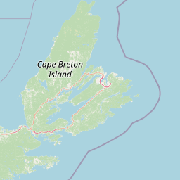
Viewpoints
Park geography
Analyzing the regional terrain, coastal landscape, and defined territorial dimensions of this protected area.
Comprehensive Geographic Profile and Mapped Boundaries of Cape Breton Highlands National Park
Explore the geographic framework of Cape Breton Highlands National Park, spanning 949 square kilometers of mountainous terrain in Nova Scotia. This profile tracks boundary coordinates, peak elevations reaching 533 meters, and diverse natural features ranging from inland waterfalls to rugged coastal capes.
Related tags
National ParksBoreal ForestsCoastal SceneryHiking TrailsWildlife Viewing
Where the mountains meet the sea on Canada's Atlantic coast
Cape Breton Highlands National Park
Cape Breton Highlands National Park is a rugged and ecologically diverse protected area spanning the northern plateau of Cape Breton Island in Nova Scotia, Canada. Established in 1936, it was the first national park in Canada's Atlantic provinces and remains one of the most distinctive landscapes in the region, where ancient mountains rise abruptly from the Atlantic Ocean coastline. The park encompasses approximately 949 square kilometers of boreal and Acadian forests, tundra-esque highlands, deep river valleys, and dramatic sea cliffs. White Hill, the highest point in Nova Scotia at 533.5 meters above sea level, marks the summit of this ancient plateau. The park is renowned for the Cabot Trail, a scenic highway that winds through its interior, offering travelers access to sweeping ocean views from steep coastal cliffs and passage through dense forested valleys. The park's ecological significance is underscored by its designation as an Important Bird Area and its role in protecting critical boreal forest habitat.
- Location
- Canada
- Park type
- National park
- Established
- 1936
- Area
- 949 km²
- Highest point
- 533 m
Location overview
Coastal protected area placement within Nova Scotia, Canada
Geographic Overview of Cape Breton Highlands National Park
Cape Breton Highlands National Park is located within the province of Nova Scotia, Canada. National designation records classify the territory as a coastal protected area managed entirely within domestic borders.
- Countries
- Canada
- Regions
- Nova Scotia
- Primary location
- Nova Scotia
- Geographic setting
- Coastal
Boundary and coordinates
Spatial limits and coordinate span across 949 square kilometers
Cape Breton Highlands National Park Boundary Map and Geographic Limits
Mapped boundaries trace the spatial footprint of Cape Breton Highlands National Park. Regional datasets define the total area of 949 square kilometers alongside estimated coordinates, spans, and center points.
- Boundary area
- 951.6 km²
- Boundary perimeter
- 186.3 km
- Northernmost point
- 46.8645° N
- Southernmost point
- 46.5957° N
- Easternmost point
- 60.3168° W
- Westernmost point
- 60.9648° W
- Geographic centre
- 46.7323° N, 60.6411° W
- North–south span
- 29.9 km
- East–west span
- 49.5 km
Elevation and terrain
Mountain relief metrics and recorded natural water features
Cape Breton Highlands National Park Terrain and Elevation Profile
Recorded elevation metrics outline a mountain relief reaching a maximum height of 533 meters across the protected area. Associated feature cards detail individual lakes, streams, peaks, and waterfalls situated within the park boundaries.
- Maximum elevation
- 533 m
- Highest point
- 533 m
Selected named natural features
Lakes
Boot Lake
Streams
Phillips Cove Brook
Lakes
Hardwood Hill Lake
Lakes
Clyburn Lake
Lakes
Beaver Lake
Environmental setting
Temperate climate zones, forested relief types, and regional habitat classifications
Cape Breton Highlands National Park Environmental Classifications and Physical Setting
Recorded landscape features and habitat types serve as interpretive categories for reading the physical setting of Cape Breton Highlands National Park. Connected taxonomy records link these environmental classifications directly to relevant regional atlas destinations.
- Relief
- Mountain
- Climate
- Temperate
- Water
- Minor water
- Forest cover
- Mostly forested
- Seasonality
- Year-round
Landscape features
Mountains · Valleys · Plateau · Cliffs · Forest · Rivers · Lakes · Beach · Coast
Habitat types
Temperate broadleaf forest · Boreal forest · Alpine meadow · Coastal habitat · Riverine habitat
Park atlas
Map the regional geography of other protected areas, exploring connected landscapes across Atlantic Canada.
Discover National Parks and Protected Areas Near Cape Breton Highlands National Park
Discover additional national parks and protected areas located in the vicinity of Cape Breton Highlands National Park, featuring diverse coastal scenery, boreal forests, and rugged mountain landscapes. Compare their unique geographic features, conservation efforts, and regional environmental importance through an atlas-style exploration of interconnected natural spaces.
Wildlife reserveNova Scotia
About 39 km away#1 closest
Southwest

Sea Wolf Island National Wildlife Area: Protected Sandstone Cliffs and Seabird Sanctuary
Coastal maritime geography and nesting habitats in Nova Scotia
Sea Wolf Island National Wildlife Area constitutes a remote sandstone sanctuary in the Gulf of St. Lawrence. Characterized by steep, eroded cliff faces and isolated terrain, this Canadian protected area remains a significant site for colonial seabird nesting, specifically supporting populations of Great Cormorants and Razorbills within the Atlantic marine ecosystem.
- Area
- 0.76 km²
- Established
- 1982
- IUCN
- Ia
Wildlife reserveFrance
About 44 km away#2 closest
Northeast

Réserve nationale de faune de l'Île-Saint-Paul Wildlife Reserve and Regional Geography
Mapping the protected landscapes of France
The Réserve nationale de faune de l'Île-Saint-Paul provides a focused look at isolated terrain and coastal environmental protection. As a designated wildlife reserve in France, it offers a distinct opportunity to study boundary-driven conservation and regional geography through a mapping perspective that highlights its remote natural character.
- Established
- 2025
- Relief
- Lowland
- Climate
- Temperate
- Access
- Access unknown
Wildlife reserveNova Scotia
About 63 km away#3 closest
Southeast
Réserve nationale de faune du Lac-Big Glace Bay: Coastal Geography and Protected Land Map
Wildlife reserve and coastal sanctuary in Nova Scotia
This protected area centers on a brackish coastal lagoon and a dynamic barrier beach system on the Atlantic coast of Nova Scotia. The reserve provides a critical migratory stopover for waterfowl, with terrain that transitions from exposed sandy shores to regenerated coastal forests on reclaimed land, offering a unique example of maritime ecological restoration.
- Area
- 3.9 km²
- Established
- 2022
- IUCN
- IV
- Relief
- Lowland
Wildlife reserveQuebec
About 98 km away#4 closest
Northwest
Réserve nationale de faune de la pointe de l'Est: Quebec Coastal Wildlife Reserve Atlas
A mapped complex of parabolic dunes, lagoons, and migratory bird habitats
Located on the Magdalen Islands, Réserve nationale de faune de la pointe de l'Est safeguards an exceptional coastal landscape defined by wind-shaped barrier spits and extensive sand dunes. This protected area offers critical insight into the geography of the Gulf of Saint Lawrence, protecting diverse habitats ranging from salt marshes to rare parabolic dune formations and freshwater wetlands.
- Area
- 7.2 km²
- Established
- 1978
- IUCN
- III
- Relief
- Lowland
National parkPrince Edward Island
131 km away#5 closest
West
Prince Edward Island National Park: A Mapped Protected Landscape within Canada's Maritime Region
Discover its geographic context and natural terrain.
Prince Edward Island National Park offers a distinct protected area for exploration within the Canadian Maritimes. As a national park, it represents a commitment to preserving specific natural landscapes and their geographic characteristics. This resource provides insight into its mapped boundaries, regional setting on Prince Edward Island, and its contribution to the broader atlas of protected lands.
- Area
- 27 km²
- Established
- 1937
- IUCN
- II
- Relief
- Lowland
Wildlife reserveNova Scotia
About 176 km away#6 closest
South
Réserve nationale de faune de l'Île-Country: Nova Scotia Coastal Protected Area Geography
Mapped island habitats and protected Atlantic coastal terrain
Explore the protected landscape of Réserve nationale de faune de l'Île-Country, a 21-hectare wildlife reserve off the coast of Nova Scotia. This detailed overview focuses on the island's coastal mosaic of cobble ridges, shrub thickets, and meadow habitats that form a vital refuge for migratory seabird colonies within the Canadian Atlantic maritime region.
- Area
- 0.21 km²
- Established
- 2024
- Relief
- Lowland
- Climate
- Temperate
National parkPrince Edward Island
About 223 km away#7 closest
West
Pituamkek National Park Reserve: Prince Edward Island National Park Atlas Exploration
Mapped protected area and regional geographic context.
Pituamkek National Park Reserve offers a unique opportunity for atlas-driven discovery, focusing on its protected status as a national park on Prince Edward Island. The page details the park's geographic setting and its role within the broader landscape context of Canada. Explore its specific mapped boundaries and understand its contribution to the network of protected natural areas, providing essential data for geographic research and landscape analysis.
- Area
- 30 km²
- Established
- 2024
- IUCN
- II
- Relief
- Lowland
Wildlife reserveNew Brunswick
About 226 km away#8 closest
West
Réserve nationale de faune du Cap-Jourimain: Protected Coastal Wetlands and Wildlife Maps
Essential geographic context for a strategic New Brunswick wildlife reserve
Examine the mapped boundaries and complex ecosystem transitions of Réserve nationale de faune du Cap-Jourimain. This federally protected area in New Brunswick offers a distinct look at coastal marshlands, tidal flats, and island topography situated at the narrowest point of the Northumberland Strait.
- Area
- 6.617 km²
- Established
- 1980
- IUCN
- IV
- Relief
- Lowland
MoriAtlas Explorer
Continue Exploring Cape Breton Highlands National Park's Geography and Boundaries
Dive deeper into the mapped context and protected landscape of Cape Breton Highlands National Park. Understanding its regional geography and specific natural terrain provides valuable insights for any atlas exploration. This structured approach to park discovery reveals the unique geographic characteristics and boundaries of this significant national park.
Browse next
Global natural geography
Explore related park routes
Explore MoriAtlas Global ParksBrowse All MoriAtlas ParksGlobal Park Map DiscoveryMoriAtlas: Browse All CountriesBrowse All MoriAtlas ContinentsNational Park Environment AtlasGrand Canyon National Park AtlasYellowstone National Park AtlasYosemite National Park Atlas and GeographySerengeti National Park AtlasGalápagos National Park Protected LandscapeBanff National Park Geography and AtlasKruger National Park Atlas EntryUluṟu-Kata Tjuṯa National Park AtlasExplore Uluru-Kata Tjuta National Park GeographyPlitvice Lakes National Park AtlasFiordland National Park Protected LandscapeGreat Smoky Mountains National Park AtlasAfghanistan National Parks and Protected AreasAlbania National Parks and Protected AreasAlgeria National Parks and Protected AreasAmerican Samoa National Parks and Protected AreasAndorra National Parks and Protected AreasAngola National Parks and Protected AreasAntarctica National Parks and Protected AreasAntigua and Barbuda Park List