

Mori Atlas logo
Nature reserveChadinga Conservation Park

A remote protected area featuring arid mallee vegetation and expansive salt lake terrain systems.

Chadinga Conservation Park: Mapping Coastal Dune Landscapes and Saline Environments in South Australia

Chadinga Conservation Park encompasses a vast coastal landscape in the far west of South Australia, characterized by the extensive Chadinga Dunes and salt lake systems. The area features undulating sand ridges, saline flats, and mallee scrub that provide a habitat for rare species like the dinosaur ant. As an undisturbed protected area, it offers a distinct view into the arid coastal geography of the Eyre Peninsula.

coastal dunessalt lakemallee scrubarid landscaperemote parkIUCN Category VI

Chadinga Conservation Park

Nature reserve

Park overview

Structured park overview, official facts, and landscape profile for Chadinga Conservation Park

Chadinga Conservation Park park facts, protected area profile, and essential visitor context

Review the core facts for Chadinga Conservation Park, including designation, size, terrain, visitor scale, habitats, and operating context in one park-focused overview.

About Chadinga Conservation Park

Chadinga Conservation Park is a relatively quiet and ecologically distinctive protected area on the far western edge of South Australia. It sits between the southern coastline of the Eyre Peninsula and a chain of inland salt lakes, with the dunes of Lake MacDonnell forming the heart of the reserve. The park covers approximately 118.54 square kilometres, most of which is made up of the Chadinga Dunes together with an adjacent salt lake and stretches of mallee vegetation. It was formerly known as the Chadinga Conservation Reserve before transitioning to its current designation, and it has been protected under South Australian conservation management since 11 November 1993.

The park is governed by the state's Department for Environment and Water and is classified internationally as an IUCN Category VI protected area. This classification reflects a balance between preserving natural values and permitting certain sustainable activities on the landscape. Within South Australia's broader network of parks, Chadinga fills a specific niche as a coastal and arid-zone reserve, sitting in a region where the transition between marine influence, dune systems, and inland saline flats creates unusual ecological conditions. Local people sometimes refer to the area as Tuckamore, a name that reflects longstanding familiarity with the dunes among nearby communities.

The setting near Penong places Chadinga in a sparsely populated part of the state, far from the major population centres of Adelaide and the Mount Lofty Ranges. Visitors approaching the park encounter a landscape characterized by exposed dunes, low mallee shrubs, and shimmering salt lakes, with road access passing through agricultural land and small service settlements. While the park lacks formal visitor infrastructure, its undeveloped character is part of its appeal: bush camping is permitted, and the open dune environment provides a sense of remoteness that is increasingly rare among South Australia's protected areas. The neighbouring salt lakes, including Red Lake and Blue Lake, add to the visual and ecological richness of the wider region beyond the park boundary.

Quick facts and research context for Chadinga Conservation Park

Chadinga Conservation Park is located in western South Australia near Penong, on the Chadinga Dunes west of Lake MacDonnell. It covers about 118.54 square kilometres of coastal dunes, mallee scrub, and salt lake environment. The park was established on 11 November 1993 and is managed by the Department for Environment and Water (South Australia). It is classified as an IUCN Category VI protected area, and the surrounding region includes several other notable salt lakes such as Red Lake and Blue Lake.

Protection and recognition

Terrestrial protected area designation and documented management scope

Chadinga Conservation Park Protection Status and Mapped Geography

Chadinga Conservation Park maintains a defined terrestrial protection scope within its regional landscape. Documented designation records and administrative boundaries provide baseline data for evaluating the protected area.

Protection details

Protection scope
Terrestrial
Transboundary protection
No
Park context

Deeper park guide and search-rich context for Chadinga Conservation Park

Chadinga Conservation Park history, landscape, wildlife, and travel context

Explore Chadinga Conservation Park through its history, landscape character, ecosystems, wildlife, conservation priorities, cultural context, and seasonal travel timing in a structured park guide built for atlas discovery and search intent.

Why Chadinga Conservation Park stands out

Chadinga is best known for its remoteness, its coastal dune and salt lake setting west of Lake MacDonnell, and its ecological significance for the dinosaur ant, a rare living-fossil species recorded within the park. The combination of mallee scrub habitats, inland-extending dune systems, and neighbouring saline lake systems gives the area a strongly arid and biologically specialized character.

Chadinga Conservation Park history and protected-area timeline

Chadinga Conservation Park was established as a protected area on 11 November 1993 under South Australian conservation legislation. Originally designated as the Chadinga Conservation Reserve, the area was later reclassified as a conservation park, reflecting its status in the state's system of protected area categories. Its protection was driven by the ecological values of the Chadinga Dunes and the adjacent lake and mallee systems, including the presence of rare and relictual fauna such as the dinosaur ant.

The reserve's establishment fits within a broader South Australian effort in the late twentieth century to formalize protection for coastal and arid-zone landscapes, many of which had previously been used for grazing or left as open crown land. Since its founding, the park has been managed by the Department for Environment and Water (South Australia), which oversees its ecological monitoring, access arrangements, and conservation programs. The IUCN Category VI classification applied to the park indicates that management is oriented toward maintaining natural ecosystems while also allowing low-intensity sustainable activities, a framework consistent with the park's permissive attitude toward bush camping and traditional land uses in the surrounding districts.

Chadinga Conservation Park landscape and geographic character

The landscape of Chadinga Conservation Park is dominated by the Chadinga Dunes, an extensive coastal dune system that lies on the western side of Lake MacDonnell. These dunes extend up to roughly three kilometres inland from the coast, forming an undulating terrain of sand ridges and swales that is shaped by prevailing winds and the proximity of the Southern Ocean. To the east of the dunes lies the park's salt lake, the largest of several saline lake systems in the area, flanked by extensive white saline flats that contrast sharply with the vegetated dune country.

Beyond the dunes and the lake, the surrounding region is characterized by low, scrubby vegetation and sandy soils typical of the arid edge of the Eyre Peninsula. Mallee woodlands and shrublands create a structurally distinctive plant cover across much of the area, with low-growing eucalypts and associated shrub species adapted to dry, sandy substrates and salt-influenced soils. The terrain is generally low-lying, without prominent hills or escarpments within the park itself, but the combination of dune ridges, salt lakes, and open scrub produces a landscape of notable visual variety.

The wider region around Chadinga includes further geological and hydrological features of interest, such as Red Lake, a small fragmented portion of Lake MacDonnell cut off by the road between Penong and Point Sinclair, and Blue Lake, a smaller saline lake to the south. Together, these lakes, the dunes, and the surrounding mallee give Chadinga a landscape identity rooted in coastal aridity and salt-influenced environments.

Chadinga Conservation Park ecosystems, habitats, and plant life

Chadinga Conservation Park lies within a transition zone between coastal dune ecosystems and arid inland habitats in far western South Australia. The dunes support vegetation communities adapted to shifting sands, salt-laden winds, and notably low rainfall, while the inland portions of the park are characterized by mallee woodlands and shrublands typical of the broader Eyre Peninsula arid zone.

The associated salt lake system adds another ecological dimension. Saline flats and seasonal water bodies create habitats distinct from those of the dune ridges, supporting specialized plant and invertebrate communities adapted to high salinity and periodic inundation. The proximity of multiple lake systems, including the main lake in the park and neighbouring lakes such as Red Lake and Blue Lake, increases the diversity of saline and arid habitats in the region.

Chadinga Conservation Park wildlife and species highlights

Although Chadinga Conservation Park is sparsely documented in popular wildlife literature, its dune and mallee habitats support a range of native fauna typical of far western South Australia. The dunes and surrounding scrub provide habitat for small ground-dwelling mammals adapted to sandy, arid environments, including the spinifex hopping mouse, which is recorded within the reserve.

The park's most famous wildlife inhabitant, however, is the dinosaur ant. This relictual invertebrate is regarded as a living fossil and has attracted scientific interest for its evolutionary position. Mallee woodlands and shrublands within the park are also likely to support typical small reptiles, birds, and invertebrates associated with arid South Australian habitats, although detailed species inventories are not broadly documented in available sources.

Chadinga Conservation Park conservation status and protection priorities

Chadinga Conservation Park's principal conservation significance lies in its protection of the Chadinga Dunes and adjacent lake and mallee environments in an otherwise heavily modified and grazed part of South Australia. By reserving a large block of coastal dune and saline lake habitat, the park contributes to maintaining ecological connectivity and habitat quality for species dependent on intact dune systems and arid scrub.

The IUCN Category VI designation indicates a management approach that emphasizes preserving natural ecosystems while permitting sustainable uses, in line with the park's permissive treatment of low-impact activities such as bush camping. The presence of rare and relictual species, including the dinosaur ant, gives the park a heightened conservation profile: protecting habitat for such species requires maintaining the dune and mallee conditions upon which they depend.

At a regional scale, Chadinga forms part of a broader network of protected and semi-protected landscapes on the far western Eyre Peninsula, complementing the conservation values of nearby coastline, lake, and scrubland areas. Management by the Department for Environment and Water ensures ongoing ecological monitoring and protection for the park's values, even in the absence of major tourism infrastructure.

Chadinga Conservation Park cultural meaning and human context

Chadinga Conservation Park carries modest but real cultural context tied to its local name and surrounding communities. Locals along this stretch of the Eyre Peninsula sometimes refer to the area as Tuckamore, a colloquial name that reflects long familiarity with the dunes among residents of Penong and nearby settlements. The park sits within a landscape that has historically been used for grazing and other low-intensity land activities, which continue in surrounding areas under compatible land-use frameworks.

Top sights and standout views in Chadinga Conservation Park

Chadinga Conservation Park's standout qualities include the long inland reach of the Chadinga Dunes, the visual contrast between white saline lake flats and vegetated dunes, and the presence of the dinosaur ant, one of Australia's most evolutionary distinctive insects. The park's undeveloped, low-facility character and roadside salt lake neighbours, including Red Lake and Blue Lake, round out a profile that emphasizes arid coastal scenery and biological rarity over visitor infrastructure.

Best time to visit Chadinga Conservation Park

Chadinga Conservation Park sits in a dry, wind-exposed part of South Australia where seasonal conditions strongly influence comfort and visibility. Cooler months between late autumn and early spring generally offer milder temperatures, calmer winds, and lower risk of extreme heat, making them more suitable for bush camping and longer walks across the dune terrain.

Warmer months bring higher temperatures and stronger drying winds, which can make extended time in the open dunes more demanding; they can also follow periods when salt lakes fluctuate and dune vegetation looks parched. Wildlife observation for small mammals and reptiles is often easier in the cooler parts of the day, while visitors interested in the salt lake scenery may find the strongest visual contrasts after dry spells, when the saline flats are at their brightest.
Monthly climate preview

Long-term representative measurements for average temperature and monthly precipitation

Chadinga Conservation Park Climate Normals and Annual Temperature Rhythm

Chadinga Conservation Park exhibits a measured annual temperature and precipitation rhythm based on multi-year NASA reference coordinates from South Australia. Reviewing the complete twelve-month climatology profile provides deeper insight into long-term monthly averages across the protected area.
Annual mean18 °C
13 °C23 °C
Jan23°
Feb22°
Mar21°
Apr19°
May16°
Jun13°
Jul13°
Aug13°
Sep15°
Oct18°
Nov20°
Dec21°
Warmest month
January

22.6 °C

Coolest month
July

12.7 °C

Wettest month
July

1.2 mm/day

Driest month
January

0.4 mm/day

Park location guide

Geography guide, regional context, and park location map for Chadinga Conservation Park

Chadinga Conservation Park park geography, regions, and map view in Australia

Understand where Chadinga Conservation Park sits in Australia through a broader geographic reading of the surrounding landscape, nearby location context, and its mapped position within the national park landscape.

How Chadinga Conservation Park fits into Australia

Australia is a constitutional monarchy and federal parliamentary democracy comprising six states and ten territories. With a population of nearly 28 million, it is one of the world's most urbanised countries, with most people concentrated on the eastern seaboard. The country has a high Human Development Index and is known for its cultural diversity, ancient Aboriginal heritage, and unique wildlife.

Wider geography shaping Chadinga Conservation Park in Australia

Australia occupies the entire Australian continent, the island of Tasmania, and numerous smaller islands. It is the world's flattest and driest inhabited continent, featuring vast deserts in the interior (the Outback), tropical rainforests along the eastern coast, and a coastline bordering the Indian and Pacific Oceans.

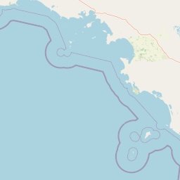
Map view of Chadinga Conservation Park

Use this park location map to pinpoint Chadinga Conservation Park in Australia, understand its exact geographic position, and read its mapped placement within the surrounding landscape more clearly.

Pigeon | © OpenStreetMap contributors

Location context for Chadinga Conservation Park

South Australia
Natural feature types

Explore the Natural Landscapes and Geographic Features of Chadinga Conservation Park

Investigate the specific landforms and water bodies that constitute the Chadinga Conservation Park ecosystem. MoriAtlas provides a clear spatial breakdown of the coastal dunes and salt lakes characterizing this remote South Australian protected area.
Park atlas

Compare adjacent coastal dune reserves, arid mallee scrub, and regional saline lake systems

Explore Parks Near Chadinga Conservation Park and Surrounding Protected Landscapes

Browse nearby national parks and protected areas sharing the arid coastal geography and remote saline habitats of Chadinga Conservation Park. Expanding the geographic scope allows for structured comparison of regional protected landscapes across the western Eyre Peninsula.
Nature reserveSouth Australia
27 km away#1 closest

West

Fowlers Bay Conservation Park: Coastal Protected Area and Regional Geography

A remote conservation landscape on the Great Australian Bight

Fowlers Bay Conservation Park stands as a vital protected area in South Australia, where vertical limestone cliffs meet horizontal chenopod plains. The park provides an essential look at the interaction between Southern Ocean maritime forces and the arid western Eyre Peninsula, offering a rare window into the transition zones of the Great Australian Bight coast.

Area
87.27 km²
Established
1993
IUCN
VI
Relief
Lowland
Nature reserveSouth Australia
About 28 km away#2 closest

Northwest

Boondina Conservation Park: Protected Landscapes and Regional Geography in South Australia

A remote nature reserve within the Yellabinna mallee woodland network.

Boondina Conservation Park is a 125 square kilometre nature reserve in far western South Australia. It forms part of the expansive Yellabinna Reserves, buffering semi-arid mallee woodland environments and supporting regional ecological processes. This IUCN Category VI area stands out for its co-management with the Far West Coast Aboriginal Corporation and its role as a preserved natural landscape where traditional land use continues.

Area
125.55 km²
Established
1993
IUCN
VI
Relief
Lowland
Marine protected areaSouth Australia
About 58 km away#3 closest

South

Murat Marine Park: Geography and Protected Marine Landscape of South Australia

Marine protected area atlas and bathymetric overview

Murat Marine Park represents an offshore sanctuary within the Great Australian Bight. This marine protected area features a blend of sediment-dominated shelf habitats and the submerged Yatala Reef, providing essential feeding grounds for diverse marine life. Explore the mapped territory and understand its placement within the wider South-west Marine Parks Network through a geographic and atlas-focused lens.

Area
937.77 km²
Established
2012
IUCN
II
Relief
Lowland
Marine protected areaSouth Australia
70 km away#4 closest

West

Great Australian Bight Marine National Park: Marine Protected Area Atlas and Geographic Context

Mapping the protected marine landscape of South Australia.

Delve into the geography and mapped boundaries of Great Australian Bight Marine National Park, a critical marine protected area located off the coast of South Australia. This resource provides an atlas-style view of the park, highlighting its geographic setting and significance as a protected marine environment. Understand the scope of this marine protected area and its place within the Australian geography, offering rich context for discovery and map exploration.

Area
1,233.22 km²
Established
1996
IUCN
II
Access
Access unknown
Nature reserveSouth Australia
137 km away#5 closest

Southeast

Eba Island Conservation Park: Coastal Landforms and Nature Reserve Geography in South Australia

A protected offshore sanctuary within Streaky Bay's coastal landscape.

Eba Island Conservation Park represents a key protected area within the coastal geography of South Australia. Composed primarily of calcarenite and limestone, the reserve features a diverse range of coastal landforms, including rugged jagged ridges, active blowholes, and sheltered coves, providing an essential habitat for seabird colonies.

Area
1.34 km²
Established
1966
IUCN
Ia
Relief
Lowland
Protected areaSouth Australia
151 km away#6 closest

Southeast

Cape Blanche Conservation Park: Eyre Peninsula Coastal Protected Landscape Map

Regional geography and conservation coastal terrain

Located on the remote western coast of the Eyre Peninsula, Cape Blanche Conservation Park serves as a dedicated sanctuary for coastal raptors and migratory birds. This protected area features a rugged intersection of limestone cliffs, sandy bays, and native coastal flora, providing an essential ecological corridor within the South Australian reserve system.

Area
810 km²
Established
2012
IUCN
III
Scope
Terrestrial
Nature reserveSouth Australia
About 163 km away#7 closest

Southeast

Calpatanna Waterhole Conservation Park: Protected Geography and Coastal Reserve Mapping

Nature reserve landscape within the South Australian Eyre Peninsula

Calpatanna Waterhole Conservation Park represents a specialized protected environment within South Australia. Centred on its namesake waterhole, the area preserves a distinctive mosaic of seasonal saline lagoons and hardy mallee eucalyptus scrub. This reserve highlights the ecological and geographic character of the Eyre Peninsula, where low undulating terrain supports unique, salt-adapted vegetation communities.

Area
36.44 km²
Established
1974
IUCN
Ia
Relief
Lowland
National parkSouth Australia
172 km away#8 closest

East

Lake Gairdner National Park: National Park with Unique South Australian Geography and Mapped Boundaries

South Australian protected area with distinct landscape characteristics.

Lake Gairdner National Park serves as a key protected area within the geographic expanse of South Australia. This national park offers a unique focus for atlas exploration, highlighting its specific landscape features and mapped boundaries. Users can delve into the park's protected status and its contribution to the regional geography, providing valuable context for understanding Australia's diverse natural protected lands and their cartographic representation.

Area
5,531.77 km²
Established
1991
IUCN
VI
Relief
Lowland

Common questions about visiting, size, designation, and location context for Chadinga Conservation Park

Chadinga Conservation Park FAQs for park facts, access, geography, and protected area context

Find quick answers about Chadinga Conservation Park, including protected-area facts, park geography, trail and visitor context, and how the park fits into its surrounding country and regional landscape.
MoriAtlas Explorer

Continue Your Protected Areas Search Across the Global Atlas

Deepen your exploration by continuing the structured search for national parks and protected areas worldwide. Utilize the comprehensive filtering capabilities to compare different conservation landscapes and refine your understanding of global park geography. Discover more about the distribution and characteristics of protected natural areas.

Global natural geography