

Mori Atlas logo
Nature reserveChocoyero-El Brujo Natural Reserve

A vertically defined nature reserve featuring cliff-nesting parakeets and critical hydrological landscapes.

Chocoyero-El Brujo Natural Reserve: Mapping Tropical Forest Watersheds and Biodiversity in Managua Department

Chocoyero-El Brujo Natural Reserve serves as a compact yet essential protected landscape on the Pacific slope of Nicaragua. The geography is characterized by deep ravines carved by the Chocoyero and El Brujo waterfalls, creating a lush, humid microclimate that supports dense forest cover and diverse wildlife populations. Beyond its ecological function, this reserve operates as a protected watershed that sustains the surrounding Managua Department with consistent freshwater resources.

tropical forestwaterfallwatershedbirdwatchingparakeet habitatwildlife reserve

Chocoyero-El Brujo Natural Reserve

Nature reserve

Park overview

Structured park overview, official facts, and landscape profile for Chocoyero-El Brujo Natural Reserve

Chocoyero-El Brujo Natural Reserve park facts, protected area profile, and essential visitor context

Review the core facts for Chocoyero-El Brujo Natural Reserve, including designation, size, terrain, visitor scale, habitats, and operating context in one park-focused overview.

About Chocoyero-El Brujo Natural Reserve

Chocoyero-El Brujo Natural Reserve is one of 78 protected areas in Nicaragua and one of the smallest by area, yet it punches above its size in both ecological and hydrological significance. Located in the municipality of Ticuantepe in the Managua department, it hugs the Pacific slope where steep topography and abundant rainfall create a remarkably lush tropical forest pocket. Declared a natural reserve in 1993 and administered by the Ministry of the Environment and Natural Resources (MARENA), the reserve has become a working example of how a small protected forest can deliver outsized benefits to a major urban area nearby.

The reserve's identity is built around two waterfalls, El Brujo and Chocoyero, which carve through the forest and create a network of wet microhabitats along their cliffs and pools. The waterfalls also give the reserve its name: the parrot-like birds known locally as chocoyos nest in the cliff walls surrounding the falls, especially Chocoyero. Beyond their tourist appeal, the falls and surrounding forest form part of a critical watershed that supplies a substantial portion of Managua's drinking water. This dual role as both a scenic natural attraction and a functional water source distinguishes Chocoyero-El Brujo from many similarly sized protected areas.

Ecologically, the reserve sits within the tropical forest biome of the Nicaraguan Pacific, where seasonal rains maintain a green canopy and dense understory. The combination of forest cover, water, and rugged terrain supports a wide range of wildlife, including mid-sized mammals, primates, reptiles, amphibians, and a particularly rich avifauna for such a small area. Despite its modest footprint, Chocoyero-El Brujo functions as a refuge of biodiversity immediately outside the capital region, and its closeness to Managua has helped shape it into a popular ecotourism stop for hiking, guided walks, birdwatching, cycling, and short overnight stays in the forest.

Quick facts and research context for Chocoyero-El Brujo Natural Reserve

Chocoyero-El Brujo is a 455-acre tropical forest reserve in the Ticuantepe municipality of the Managua department, Pacific Nicaragua, managed since 1993 under the Ministry of the Environment and Natural Resources (MARENA). The reserve protects two waterfalls whose cliff faces host green Pacific parakeets, the species for which the site is named. It supplies a significant share of Managua's drinking water, contributing an estimated 20 percent of the city's water consumption, and supports populations of howler and white-faced monkeys alongside a wide roster of birds, mammals, reptiles, amphibians, and plants.

Protection and recognition

Review documented terrestrial protection scope and international recognition records.

Chocoyero-El Brujo Natural Reserve Protection Status and Governance Data

Chocoyero-El Brujo Natural Reserve maintains a documented terrestrial protection scope within the regional conservation inventory. Fact records detail official designation history, management frameworks, and international recognition sources without external speculation.

Protection details

Protection scope
Terrestrial
Transboundary protection
No
Park context

Deeper park guide and search-rich context for Chocoyero-El Brujo Natural Reserve

Chocoyero-El Brujo Natural Reserve history, landscape, wildlife, and travel context

Explore Chocoyero-El Brujo Natural Reserve through its history, landscape character, ecosystems, wildlife, conservation priorities, cultural context, and seasonal travel timing in a structured park guide built for atlas discovery and search intent.

Why Chocoyero-El Brujo Natural Reserve stands out

Chocoyero-El Brujo is best known for being a small but ecologically rich tropical forest reserve wrapped around two scenic waterfalls that double as a key source of drinking water for nearby Managua. The cliffs around the Chocoyero and El Brujo falls host colonies of the green Pacific parakeet, locally called chocoyo, giving the reserve both its name and a defining visual and acoustic identity. Its combination of watershed function, parakeet habitat, and accessibility from the capital has made it a flagship example of urban-adjacent conservation in Nicaragua.

Chocoyero-El Brujo Natural Reserve history and protected-area timeline

Chocoyero-El Brujo was declared a natural reserve in 1993, formally placing the forested watershed under national protection in recognition of its ecological and water-supply value. Since then it has been administered by Nicaragua's Ministry of the Environment and Natural Resources, known as MARENA, as one of 78 protected areas across the country. The reserve's relatively small footprint, around 455 acres, was already a defining trait at the time of designation, yet protection has allowed its tropical forest cover and wildlife populations to remain intact in a region that is otherwise rapidly urbanizing toward Managua. Over the following decades it has also grown in reputation as a local ecotourism destination, eventually drawing an estimated 10,000 visitors per year by the mid-2000s.

Chocoyero-El Brujo Natural Reserve landscape and geographic character

The reserve's landscape is defined by steep, forested ravines carved by water on the Pacific slope of Nicaragua. Two named waterfalls, El Brujo and Chocoyero, drop through the forest along cliffs that are partly hollowed out and used as nesting sites by the parakeets that lend the area its name. Between the falls, wet rock faces, mossy ledges, and shaded pools create a microclimate within the reserve that contrasts with the drier lowlands typical of the surrounding Pacific region. The terrain is compact, dense, and vertically varied, with ridgelines, narrow trails, and stream channels weaving through a continuous tropical forest canopy.

Chocoyero-El Brujo Natural Reserve ecosystems, habitats, and plant life

Ecologically, Chocoyero-El Brujo is a tropical forest reserve shaped by water. Persistent humidity from rainfall and the waterfalls sustains a lush canopy and understory, allowing plant and animal communities to thrive in a small footprint. The reserve is among the smaller protected areas in Nicaragua, but the combination of forest cover, ravine habitat, and freshwater creates a layered ecosystem of cliffs, streams, and shaded interior forest. This ecological complexity supports a wide variety of plants and vertebrate life, much of which depends on the wet, sheltered conditions that the waterfalls and ravines maintain throughout the year.

Chocoyero-El Brujo Natural Reserve wildlife and species highlights

Wildlife is one of the reserve's strongest draws, supported by roughly 113 bird species, 29 mammal species, and 21 reptile and amphibian species. Birdwatchers commonly encounter toucans, hummingbirds, and the green Pacific parakeet, locally known as chocoyo, which nests in the cliff walls near the waterfalls and gives the reserve its name. Mammals regularly spotted include tigrillos, agoutis, and deer, while two monkey species are among the most visible residents: howler monkeys, recognizable by their vocalizations in the forest canopy, and smaller white-faced monkeys. Reptiles, amphibians, and a wide plant community round out a reserve that delivers a notably diverse vertebrate count for its small area.

Chocoyero-El Brujo Natural Reserve conservation status and protection priorities

Chocoyero-El Brujo is conserved primarily as a functioning watershed reserve, protecting forest cover that supplies an estimated 20 percent of Managua's water consumption and around twenty million gallons of water per day. Its 1993 designation as a natural reserve under MARENA recognized that ecological and hydrological value at a national level, anchoring the forest's protection against the urban pressures spreading out from the nearby capital. The reserve's combination of parakeet cliff habitat, primate populations, and rich plant and vertebrate communities also gives it ecological importance beyond its water role. By keeping a sliver of tropical forest intact in the metropolitan hinterland, Chocoyero-El Brujo helps anchor regional biodiversity while serving the everyday water needs of one of Nicaragua's largest cities.

Chocoyero-El Brujo Natural Reserve cultural meaning and human context

The reserve carries local cultural resonance through the name chocoyo, a widely recognized Nicaraguan term for the green Pacific parakeet, and through its long-standing role as a traditional point of contact with nature for residents of greater Managua. Before formal protections were established, the waterfalls and surrounding forest were already a familiar green escape for people in the capital region, and that relationship has carried forward into modern ecotourism. Local people also have an everyday stake in the reserve through its function as a community water source, linking forest conservation to household life well beyond park boundaries.

Top sights and standout views in Chocoyero-El Brujo Natural Reserve

The Chocoyero and El Brujo waterfalls are the visual centerpiece of the reserve, with cliff-nesting parakeets swarming around the rock faces and lending the site its defining sound and color. The dense tropical forest trails around the falls give visitors unusually close access to howler and white-faced monkeys, as well as toucans, hummingbirds, agoutis, and other forest wildlife within a short distance of Managua. Just as significant is what lies beneath the scenery: a protected watershed that delivers a substantial share of the capital's water and demonstrates how a small forest reserve can carry both ecological and human value.

Best time to visit Chocoyero-El Brujo Natural Reserve

Because Chocoyero-El Brujo sits in Nicaragua's tropical Pacific climate, the reserve tends to be green, humid, and biologically active year round, with the wet season bringing fuller waterfalls, thicker vegetation, and more active wildlife, and the drier months offering easier trail conditions and more reliable views. Birdwatchers will often find the parakeet colonies around the cliffs engaging in any season, while photographers may prefer clearer, less rainy windows. Visitors should generally expect tropical conditions regardless of timing and plan around rainfall rather than around a narrow peak window.
Monthly climate preview

Long-term representative temperature and precipitation patterns across the year

Chocoyero-El Brujo Natural Reserve Climate Normals and Weather by Month

Chocoyero-El Brujo Natural Reserve exhibits a measured annual cycle of temperature and precipitation based on long-term coordinates in Managua Department. The complete monthly climate record details complete averages across all twelve periods for comprehensive geographical study.
Annual mean28 °C
26 °C30 °C
Jan27°
Feb28°
Mar29°
Apr30°
May29°
Jun28°
Jul27°
Aug28°
Sep27°
Oct26°
Nov26°
Dec27°
Warmest month
April

30.2 °C

Coolest month
November

26.5 °C

Wettest month
September

8 mm/day

Driest month
January

0.1 mm/day

Park location guide

Geography guide, regional context, and park location map for Chocoyero-El Brujo Natural Reserve

Chocoyero-El Brujo Natural Reserve park geography, regions, and map view in Nicaragua

Understand where Chocoyero-El Brujo Natural Reserve sits in Nicaragua through a broader geographic reading of the surrounding landscape, nearby location context, and its mapped position within the national park landscape.

How Chocoyero-El Brujo Natural Reserve fits into Nicaragua

Nicaragua is a Central American country spanning 130,375 km² with a population of approximately 6.7 million. It borders Honduras, Costa Rica, the Caribbean Sea, and the Pacific Ocean. The official language is Spanish, and the currency is the Córdoba. Known for its agricultural productivity and cultural diversity, Nicaragua has a history dating back to indigenous civilizations before Spanish conquest in the 16th century.

Wider geography shaping Chocoyero-El Brujo Natural Reserve in Nicaragua

Nicaragua occupies a strategic position in Central America, bordered by Honduras to the north, the Caribbean Sea to the east, Costa Rica to the south, and the Pacific Ocean to the west. The country also shares maritime borders with El Salvador and Colombia. The terrain includes coastal plains, volcanic highlands, and interior valleys. Lake Managua and Lake Nicaragua are major freshwater bodies.

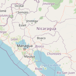
Map view of Chocoyero-El Brujo Natural Reserve

Use this park location map to pinpoint Chocoyero-El Brujo Natural Reserve in Nicaragua, understand its exact geographic position, and read its mapped placement within the surrounding landscape more clearly.

Pigeon | © OpenStreetMap contributors

Location context for Chocoyero-El Brujo Natural Reserve

Managua Department
Park atlas

Compare surrounding regional geography and connected tropical forest reserves

Other Parks and Protected Areas Near Chocoyero-El Brujo Natural Reserve

Visitors exploring Chocoyero-El Brujo Natural Reserve can browse adjacent protected areas across the surrounding region. Geographic comparison reveals broader patterns in Pacific slope conservation landscapes and regional watershed terrain.
National parkNicaragua
About 5.6 km away#1 closest

Southeast

Masaya Volcano National Park: Nicaragua National Park Atlas & Landscape Context

Explore the mapped boundaries of this unique volcanic terrain.

Masaya Volcano National Park offers a distinct focus for atlas exploration within Nicaragua's broader geographic framework. This page details the park's identity as a protected landscape, highlighting its volcanic terrain and mapped features. Understand its significance within the national park system and its contribution to the mapped natural heritage of Central America.

IUCN
II
Relief
Mountain
Access
Access unknown
A soft watercolor painting of a calm lake surrounded by rolling hills and distant mountains, with light vegetation in the foreground.
Nature reserveNicaragua
About 17 km away#2 closest

Southeast

Laguna de Apoyo Nature Reserve: Geographic Profile and Protected Volcanic Caldera

A study of volcanic lake hydrology and tropical dry forest terrain.

Laguna de Apoyo Nature Reserve is a prominent protected landscape in Nicaragua, centered on a deep crater lake of volcanic origin. This nature reserve protects a circular caldera filled by an endorheic lake, ringed by diverse tropical dry forest. The area serves as a significant site for understanding geological landforms and the specialized freshwater biodiversity found within its sheltered basin.

Area
35 km²
Established
1991
IUCN
IV
Relief
Mixed relief
National parkNicaragua
About 50 km away#3 closest

Southeast

Zapatera Archipelago National Park: Nicaragua National Park Atlas and Protected Landscape Explorer

Explore the mapped boundaries and regional geography.

Zapatera Archipelago National Park serves as a distinct national park within Nicaragua, offering a focused point for exploring protected landscapes and their geographic context. This entry details the park's mapped boundaries and its significance within the atlas of Central American natural areas. Users can understand its role as a protected entity and its contribution to the region's mapped geography, supporting structured discovery of its natural landscape identity.

IUCN
II
Climate
Tropical
Scope
Mixed
Water
Water-dominated
Nature reserveNicaragua
About 119 km away#4 closest

Northeast

Cerro Pancasan Natural Reserve: Geographic Overview of a Nicaraguan Protected Forest Hill

Exploring mountain-slope terrain and regional watershed conservation

As a significant hill reserve in western Nicaragua, Cerro Pancasan Natural Reserve protects essential tropical forest cover against agricultural encroachment. This entry provides a detailed look at the reserve's topography, its role in maintaining regional stream flow, and its place within the country-wide SINAP network of protected land.

Scope
Terrestrial
National parkGuanacaste Province
About 119 km away#5 closest

South

Santa Rosa National Park: Guanacaste Province National Park Protected Area

Mapped natural landscape and regional geography.

Santa Rosa National Park is a vital protected area within Costa Rica's Guanacaste Province. This detail page offers an atlas-focused view of the park, highlighting its geographic setting and mapped boundaries. It serves as a primary resource for understanding the park's protected landscape identity and its contribution to regional conservation geography, supporting structured exploration for users interested in natural areas.

Area
815.31 km²
Established
1966
IUCN
II
Climate
Tropical
National parkGuanacaste Province
About 124 km away#6 closest

Southeast

Guanacaste National Park: A Protected Landscape within Guanacaste Province's Geography

Explore mapped park boundaries and regional natural landscape context.

Delve into the protected landscape of Guanacaste National Park, a significant national park located within Guanacaste Province. This entry provides a focused view of its geographic features, mapped protected areas, and its role within the regional terrain. Understand the park's specific natural landscape character and its placement in the broader atlas of conservation lands.

Area
340 km²
Established
1991
IUCN
II
Relief
Mixed relief
Nature reserveChinandega Department
About 153 km away#7 closest

Northwest

Estero Padre Ramos Natural Reserve: Protected Coastal Estuary and Turtle Habitat in Nicaragua

Mangrove forests and tidal landscapes of the Pacific coast

Gain insights into the geography and protected status of Estero Padre Ramos Natural Reserve. This coastal sanctuary in the Chinandega Department features pristine estuarine channels, mudflats, and rocky reefs that define the local terrain and support international marine turtle conservation efforts.

Area
91.57 km²
Established
1983
IUCN
IV
Relief
Lowland
National parkGuanacaste Province
About 166 km away#8 closest

Southeast

Rincón de la Vieja National Park: Costa Rican National Park Atlas Entry

Mapped protected landscape and regional geography.

Gain a structured understanding of Rincón de la Vieja National Park as a key protected area within Guanacaste Province. This detail page offers an atlas-focused perspective, highlighting its mapped boundaries and regional geographic significance. Explore how this national park contributes to the protected landscapes of Costa Rica, providing essential context for geographic discovery.

Area
141.61 km²
Established
1973
IUCN
II
Climate
Tropical

Common questions about visiting, size, designation, and location context for Chocoyero-El Brujo Natural Reserve

Chocoyero-El Brujo Natural Reserve FAQs for park facts, access, geography, and protected area context

Find quick answers about Chocoyero-El Brujo Natural Reserve, including protected-area facts, park geography, trail and visitor context, and how the park fits into its surrounding country and regional landscape.
MoriAtlas Explorer

Continue Your Protected Areas Search Across the Global Atlas

Deepen your exploration by continuing the structured search for national parks and protected areas worldwide. Utilize the comprehensive filtering capabilities to compare different conservation landscapes and refine your understanding of global park geography. Discover more about the distribution and characteristics of protected natural areas.

Global natural geography
