Mori Atlas logo
Protected landscapeCiśniańsko-Wetliński Park Krajobrazowy

Examining the ecological buffers, ridge topography, and mountain forest layers of this Bieszczady region.

Ciśniańsko-Wetliński Park Krajobrazowy: A Mapped Analysis of Carpathian Protected Landscapes

Ciśniańsko-Wetliński Park Krajobrazowy represents a vast, 51,000-hectare protected area in southeastern Poland, serving as a vital western buffer zone for the Bieszczady mountain range. This region acts as a transboundary conservation corridor, extending into Slovakia and forming an integral part of the Eastern Carpathians Biosphere Reserve. The terrain is defined by its layered altitudinal vegetation, from mixed beech forests to subalpine ridges approaching 1,200 meters in elevation.

landscape parkWestern BieszczadyCarpathian mountainsbuffer zonebiodiversitylarge carnivores

Ciśniańsko-Wetliński Park Krajobrazowy

Protected landscape

Park overview

Structured park overview, official facts, and landscape profile for Cisna-Wetlina Landscape Park

Cisna-Wetlina Landscape Park park facts, protected area profile, and essential visitor context

Review the core facts for Cisna-Wetlina Landscape Park, including designation, size, terrain, visitor scale, habitats, and operating context in one park-focused overview.

About Cisna-Wetlina Landscape Park

Cisna-Wetlina Landscape Park occupies a central position within the protected-area network of the Bieszczady Mountains. Although not a national park, it plays a strategically important role: it surrounds the western approaches to Bieszczady National Park, absorbing and extending conservation values outward from the strictly protected core. Because the park spans the communes of Komańcza, Zagórz, Cisna, Baligród, Solina, and Czarna, it crosses much of the populated, tourism-rich western Bieszczady, where small mountain villages, pastoral valleys, and forested ridges together form the cultural backdrop of the mountains.

The landscape is shaped by the flysch geology typical of the Outer Carpathians, with alternating sandstone and shale layers producing ridges, valleys, and deeply incised river courses. Elevations within the park rise to nearly 1,200 meters, and the altitudinal gradient generates a clearly visible vegetation zonation: deciduous foothill forests give way to mixed and coniferous montane forests, and in the highest parts of the park these give way to subalpine grasslands and windswept summits. This vertical layering is one of the defining characteristics of the park's natural environment.

Ecologically, the park's value lies both in the continuity of its forest cover and in its position within a larger Carpathian ecosystem. Forests account for roughly 83 percent of the park's area, and much of this woodland remains in a relatively natural state, providing habitat for the full guild of large Carpathian mammals. The park is also significant for its exceptional populations of common yew (Taxus baccata), a species that has become rare across much of Europe, with two dedicated nature reserves protecting ancient yew individuals.

Culturally, the park preserves a landscape marked by the complex history of the Polish-Slovak borderland. The region was once a flourishing interwar tourist destination, with pensions in Cisna and Jabłonki and a separate resort district in Komańcza. The upheavals of the mid-twentieth century emptied the area, but mountain villages and scattered hamlets remain characteristic features of the park's inhabited valleys today. Together with the neighboring protected areas, Cisna-Wetlina Landscape Park forms one of the cornerstones of conservation in the Polish Carpathians and a key element of the broader Eastern Carpathians Biosphere Reserve.

Quick facts and research context for Cisna-Wetlina Landscape Park

Cisna-Wetlina Landscape Park lies in the Podkarpackie Voivodeship of southeastern Poland, within the Western Bieszczady mezoregion. It was established in 1992 by regulation of the voivode of Krosno and now covers approximately 51,461 hectares, with forest cover at roughly 83 percent. The park designates the landscape buffer for the Bieszczady National Park on its western flank and is jointly listed, with the national park and the San River Valley Landscape Park, as part of the International Biosphere Reserve 'Eastern Carpathians.' To the south it borders Slovakia's Eastern Carpathians Protected Landscape Area and Poloniny National Park.

Protection and recognition

Explore documented terrestrial protection frameworks and management data.

Ciśniańsko-Wetliński Park Krajobrazowy Protection Status and Recognition

Ciśniańsko-Wetliński Park Krajobrazowy features a documented terrestrial protection status within its regional landscape. Structured records compile available designation details and management scope for thorough natural area research.

Protection details

Protection scope
Terrestrial
Transboundary protection
No
Park context

Deeper park guide and search-rich context for Cisna-Wetlina Landscape Park

Cisna-Wetlina Landscape Park history, landscape, wildlife, and travel context

Explore Cisna-Wetlina Landscape Park through its history, landscape character, ecosystems, wildlife, conservation priorities, cultural context, and seasonal travel timing in a structured park guide built for atlas discovery and search intent.

Why Cisna-Wetlina Landscape Park stands out

The park is best known as the forested western buffer of the Bieszczady National Park and as a core component of the transboundary Eastern Carpathians Biosphere Reserve. It is recognized for the layered, altitudinal arrangement of Carpathian forest vegetation across peaks that approach 1,200 meters, and for the presence of two protected yew reserves that preserve one of the largest natural yew populations in Poland. Its wildlife profile also sets it apart. Cisna-Wetlina supports a complete set of large Carpathian predators, including brown bears, wolves, Eurasian lynx, and European wildcat, sustained by the park's extensive, lightly managed forests and its position as a transboundary habitat between Poland and Slovakia.
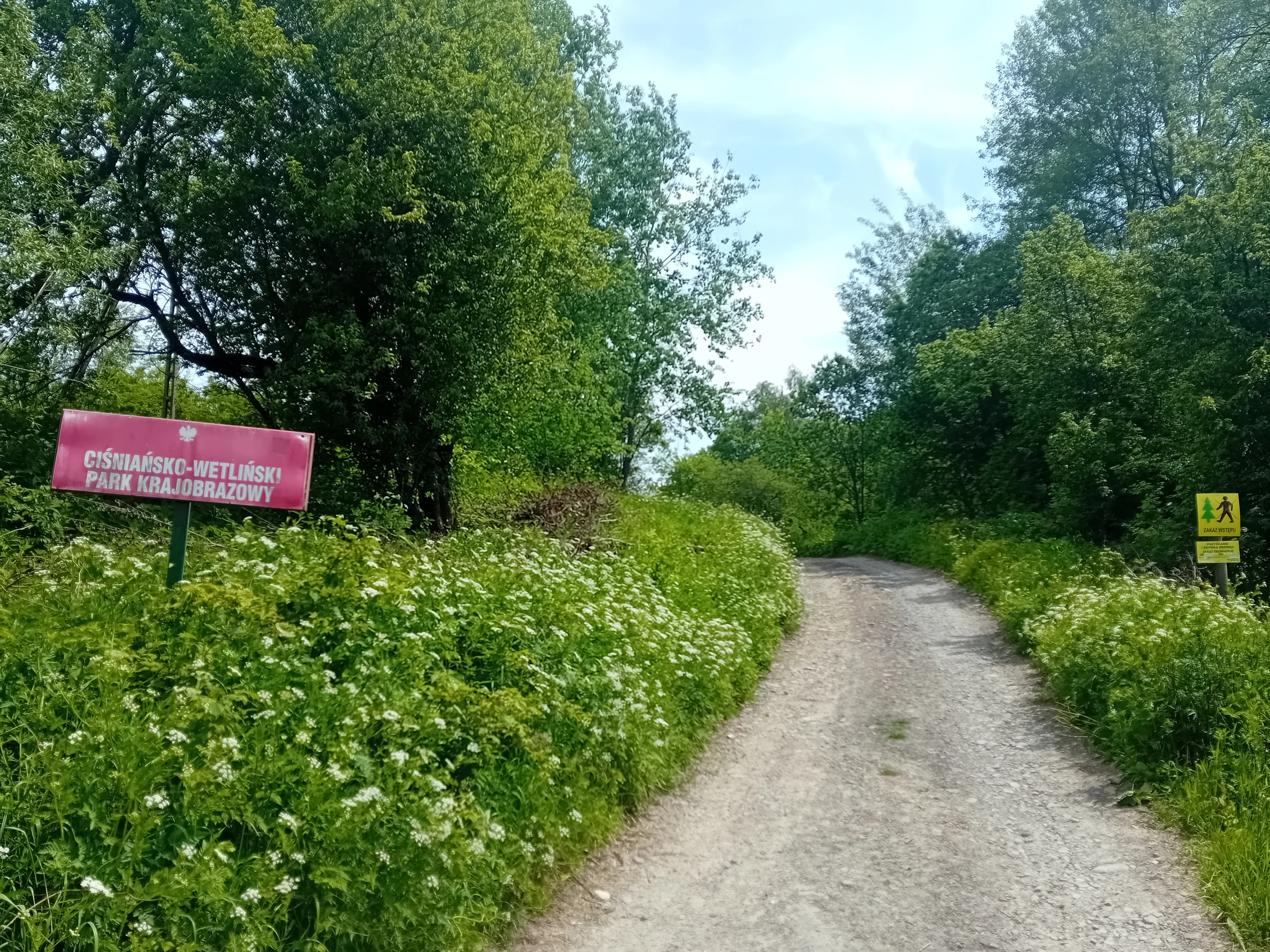
A dirt path leading into a green forest with a red park entrance sign on the left and a small yellow trail marker on the right.
Park entrance sign for Ciśniańsko-Wetliński Park Krajobrazowy located along a gravel trail.

Cisna-Wetlina Landscape Park history and protected-area timeline

The area that is now the Cisna-Wetlina Landscape Park has a long pre-park history shaped by tourism and demographic change. Even before any formal protection existed, this part of the Bieszczady was a recognized and developed tourist region in the 1930s. Pensions operated in Cisna and Jabłonki, and Komańcza had its own distinct summer-resort district, with a network of marked hiking trails connecting the main localities. In both summer and winter, the area drew large numbers of vacationers, hikers, and skiers.

This pattern was broken by the Second World War and the turbulent years that followed it. Events in 1945 and 1947 led to the depopulation of large parts of the western Bieszczady. The loss of population halted not only tourism but also much of the region's broader development. For several years the area was thinly inhabited and largely abandoned in everyday terms. It was only in the 1950s that interest in the Bieszczady resumed, with the first post-war expeditions, sometimes escorted by border-guard soldiers, drawing national attention and attracting large numbers of visitors. University students were among the earliest returnees and helped to establish a network of tent bases at places such as Łopiennik, Bystre, Przysłup, and Komańcza, laying informal groundwork for the area's later tourist revival.

The formal conservation history of the landscape began in 1992. The park was established on 27 March 1992 by Regulation No. 17 of the Voivode of Krosno, bringing a coherent system of landscape-level protections to the populated western Bieszczady. Since that year, the park has also formed part of the International Biosphere Reserve 'Eastern Carpathians,' linking it institutionally and ecologically with neighboring protected areas in Slovakia, including the Eastern Carpathians Protected Landscape Area and Poloniny National Park.

Cisna-Wetlina Landscape Park landscape and geographic character

The landscape of Cisna-Wetlina Landscape Park is a classic expression of the flysch Outer Carpathians. Layers of Carpathian sandstone and shale alternating across the terrain have been cut by rivers and streams into a pattern of parallel ridges and valleys, producing the characteristic corrugated skyline of the Bieszczady. Elevations within the park approach nearly 1,200 meters above sea level, with summit ridges often broad and grassy rather than sharp, in the manner typical of the range.

The valleys are deeply incised and contain some of the park's most distinctive features. The Osława River, for example, cuts through a narrow, dramatic gorge near Duszatyn, preserved as a landscape nature reserve. Water-driven erosion has also shaped boulder fields and rock formations such as those at the Gołoborze geological reserve. These landforms contrast with the gentler, forested slopes and high-mountain meadows that occupy much of the park's interior.

Across this varied terrain, vegetation follows elevation in clearly readable tiers. Lower slopes carry mixed deciduous forests of beech, oak, and sycamore; mid-elevations are dominated by beech and fir stands; and higher ridges support spruce forest and, near the summits, subalpine grasslands and dwarf-shrub communities. The combination of alternating ridge and valley topography, deeply cut river gorges, boulder fields, and a fully developed altitudinal vegetation sequence gives the park a strongly layered visual identity.

Cisna-Wetlina Landscape Park ecosystems, habitats, and plant life

Ecologically, the Cisna-Wetlina Landscape Park is dominated by forest. Roughly 83 percent of its area is wooded, and great swathes of this forest remain in a relatively natural condition. The altitudinal gradient within the park produces a textbook sequence of Carpathian forest types, from foothill deciduous woodlands through mixed and coniferous stands to subalpine communities near the highest summits.

Beech forests are a central feature of the park's forest belt and occupy much of the middle elevations, often in combination with fir on more sheltered slopes. Higher up, spruce takes over as the dominant conifer. Along the park's rivers and streams, floodplain and gallery forests are also well represented, including the alder swamp forest protected in the Olszyna Łęgowa w Kalnicy reserve near Kalnica, one of the few remaining examples of its kind in the Polish Bieszczady.

A particularly distinctive element of the park's nature is its population of common yew (Taxus baccata). Two nature reserves, Cisy na Górze Jawor and Woronikówka, protect ancient yew trees and associated mixed stands, preserving one of the most important native yew refuges in Poland. The park's mix of well-preserved forest communities, boulder and scree habitats, river gorges, and high-mountain grasslands gives it a high overall habitat diversity within the Carpathian system.

Cisna-Wetlina Landscape Park wildlife and species highlights

Cisna-Wetlina Landscape Park is one of the last places in Poland where the full set of large Carpathian mammals remains present. Brown bears roam the park's forested valleys and ridges, and the park's extensive woodlands also support stable populations of gray wolves. The Eurasian lynx, one of the rarest cats in Europe, is found here as well, taking advantage of the unbroken forest cover that extends across the border into Slovakia.

Equally significant is the presence of the European wildcat, which remains at the western edge of its European range in this part of the Carpathians. The continued coexistence of these four large-mammal predators within a single protected-area complex is unusual within Poland and reflects the park's combination of large, contiguous forest tracts, low human density, and connection to transboundary habitats.

Beyond the headline predators, the park supports a wide range of typical Carpathian wildlife, including red deer, roe deer, and wild boar across its forested ridges and valleys. The mix of forest, meadow, river, and rocky habitats provides niches for a broad spectrum of smaller mammals, birds, and other fauna. Its role as a refuge for large carnivores, however, is the single most defining element of the park's wildlife identity and a central reason for its inclusion in the Eastern Carpathians Biosphere Reserve.

Cisna-Wetlina Landscape Park conservation status and protection priorities

The park's conservation significance rests on both its national and its transboundary role. At the Polish level, it functions as the landscape-scale buffer surrounding the western flank of the Bieszczady National Park, extending protection beyond the strictly managed core into the populated valleys, traditional villages, and working forests of the western Bieszczady. This buffer function is essential for the long-term viability of species that require large, contiguous habitats and that do not respect park boundaries.

At the international level, the park is a core component of the International Biosphere Reserve 'Eastern Carpathians,' a designation that links protected areas on both sides of the Polish-Slovak border. To the south, the park adjoins Slovakia's Eastern Carpathians Protected Landscape Area and Poloniny National Park, creating a continuous Carpathian conservation corridor in which animal populations, forest communities, and ecological processes operate across national boundaries.

The presence of seven nature reserves adds a finer-grained layer to the park's conservation value. These reserves protect specific natural features that are exceptional even by Carpathian standards, including ancient yew stands, old-growth alder forests, the Osława River gorge, boulder fields, and an unusual abiotic reserve at Zwiezło. Together, the landscape-level protection of the park and the strict protection within these reserves make Cisna-Wetlina one of the most ecologically significant areas in the Polish mountains.

Cisna-Wetlina Landscape Park cultural meaning and human context

The cultural context of the park is shaped by the distinctive history of the western Bieszczady. In the 1930s, the area was a lively mountain-tourist region with pensions, summer resorts, and marked hiking trails. Komańcza in particular had a dedicated resort district. The mid-twentieth-century upheavals associated with the Second World War and the events of 1945 to 1947 emptied much of the region, and only parts of that earlier settlement pattern survive in the form of present-day villages, hamlets, and scattered mountain settlements.

From the 1950s onward, the area was gradually re-peopled and re-discovered as a tourist destination, in large part through the activity of university students who set up tent bases in places such as Łopiennik, Bystre, Przysłup, and Komańcza. Today the park overlaps with an inhabited, working mountain landscape of small villages and rural communities, a feature that distinguishes it from the strictly protected core of the neighboring national park and reinforces its identity as a lived-in Carpathian landscape under conservation management.

Top sights and standout views in Cisna-Wetlina Landscape Park

Among the park's most notable features are its two yew reserves, Cisy na Góry Jawor and Woronikówka, which protect some of Poland's most important native yew populations. The park also contains the landscape reserves of the Osława River gorge near Duszatyn and Sine Wiry, the old-growth alder swamp forest of Olszyna Łęgowa w Kalnicy, the boulder-field geological reserve at Gołoborze, and the abiotic reserve at Zwiezło. Together these reserves showcase the park's unusually wide range of habitats, from river gorges and boulder fields to ancient forests and yew stands.

Beyond its reserves, the park's defining highlights are its position as the western buffer of the Bieszczady National Park, its membership in the Eastern Carpathians Biosphere Reserve, and its function as a transboundary habitat connecting Poland with Slovakia's Eastern Carpathians Protected Landscape Area and Poloniny National Park. Few landscape parks in Poland combine such a strong altitudinal vegetation sequence, such rich large-mammal fauna, and such a clear international conservation role.

Best time to visit Cisna-Wetlina Landscape Park

The park's character changes significantly with the seasons, and the most rewarding periods typically align with late spring, summer, and early autumn. In late spring and early summer, the deciduous forests of the lower slopes are in full leaf, the beech stands of the mid-elevations are particularly vivid, and wildflower meadows at higher elevations come into bloom. Summer brings the warmest conditions for hiking across the altitudinal vegetation belts and into the high-mountain grasslands near the park's upper summits, while also providing the best opportunities to encounter the park's extensive forest landscapes.

Autumn, with its cooler weather and changing forest colors, is also well suited to exploring the park's wooded valleys, rivers, and the landscape reserves of Sine Wiry and the Osława gorge. The higher elevations can experience early snow and harsher conditions, and winter conditions generally make the more remote parts of the park suitable only for experienced visitors. In general, the warmer months offer the most reliable access to the park's full range of landscapes and ecosystems.

Monthly climate preview

Long-term temperature ranges and precipitation averages across twelve recorded months

Ciśniańsko-Wetliński Park Krajobrazowy Climate Normals and Weather by Month

Representative coordinates record distinct annual temperature swings and precipitation patterns across the protected landscape. Examining the full monthly climatology profile provides deeper insight into measured baseline conditions at elevation.
Annual mean7 °C
-6 °C18 °C
Jan-6°
Feb-4°
Mar
Apr
May13°
Jun16°
Jul18°
Aug18°
Sep13°
Oct
Nov
Dec-4°
Warmest month
July

18.2 °C

Coolest month
January

-5.5 °C

Wettest month
July

3.3 mm/day

Driest month
March

1.7 mm/day

Park location guide

Geography guide, regional context, and park location map for Cisna-Wetlina Landscape Park

Cisna-Wetlina Landscape Park park geography, regions, and map view in Poland

Understand where Cisna-Wetlina Landscape Park sits in Poland through a broader geographic reading of the surrounding landscape, nearby location context, and its mapped position within the national park landscape.

How Cisna-Wetlina Landscape Park fits into Poland

Poland, officially the Republic of Poland, is a Central European country spanning from the Baltic Sea in the north to the Carpathian Mountains in the south. It borders Germany, Czech Republic, Slovakia, Ukraine, Belarus, Lithuania, and Kaliningrad Oblast. The country has a temperate climate, diverse landscapes, and is known for its rich history, cultural heritage, and strong economic position within the EU.

Wider geography shaping Cisna-Wetlina Landscape Park in Poland

Poland occupies 312,696 km2 in Central Europe, extending from the Baltic Sea coast in the north to the Sudetes and Carpathian Mountains in the south. It borders Germany to the west, Czech Republic and Slovakia to the south, Ukraine and Belarus to the east, and Lithuania and Kaliningrad Oblast to the northeast. The landscape includes lowland plains, uplands, and mountain ranges.

Map view of Cisna-Wetlina Landscape Park

Use this park location map to pinpoint Cisna-Wetlina Landscape Park in Poland, understand its exact geographic position, and read its mapped placement within the surrounding landscape more clearly.

Pigeon | © OpenStreetMap contributors

Location context for Cisna-Wetlina Landscape Park

Podkarpackie Voivodeship
Natural feature types

Explore the Natural Features of Ciśniańsko-Wetliński Park Krajobrazowy

Examine the detailed landscape features, geological sites, and forest zones that shape the environment of Ciśniańsko-Wetliński Park Krajobrazowy. Utilize this geographic data to understand the landform distribution and mountain terrain patterns characteristic of the Western Bieszczady region.
Recorded earthquake history

Examine the Seismic History of Ciśniańsko-Wetliński Park Krajobrazowy

Review the recorded seismic activity associated with the mountain terrain of this protected landscape. MoriAtlas maintains a clear, map-oriented catalogue of historical earthquake events that occurred within proximity to the park boundaries for research and geographic reference.

Ciśniańsko-Wetliński Park Krajobrazowy Earthquakes

Catalogued events

4 events

Strongest magnitude

Magnitude 5

Most recent event

Oct 9, 2023

This history includes earthquakes recorded inside the park or within 50 km of its borders

Visual reference for Carpathian ridges, river gorges, and forest habitats

Ciśniańsko-Wetliński Park Krajobrazowy Photos and Mountain Landscapes

Visual documentation of Ciśniańsko-Wetliński Park Krajobrazowy reveals the alternating ridges, deep river gorges, and layered vegetation zones characteristic of the Western Bieszczady. Examining protected area imagery provides concrete insight into the terrain, forest habitats, and topography that define this transboundary mountain region.

A dirt path leading into a green forest with a red park entrance sign on the left and a small yellow trail marker on the right.

Park atlas

Compare adjacent mountain reserves and transboundary conservation areas across the region.

Parks Near Ciśniańsko-Wetliński Park Krajobrazowy and Surrounding Protected Landscapes

Visitors exploring Ciśniańsko-Wetliński Park Krajobrazowy can browse nearby national parks and connected forest reserves within the surrounding region. Comparing adjacent protected landscapes provides valuable context on regional mountain geography, transboundary wildlife corridors, and shared Carpathian terrain.
National parkSubcarpathian Voivodeship
Park boundaries overlap#1 closest

East

Bieszczady National Park: A Protected Landscape of the Eastern Carpathians

Explore mapped terrain, alpine meadows, and old-growth forests.

Discover Bieszczady National Park, a significant national park located in the Subcarpathian Voivodeship of Poland, within the Eastern Carpathian mountain range. This protected area is renowned for its vast expanses of old-growth beech forests, the characteristic połoniny alpine meadows, and its status as a UNESCO World Heritage Site, underscoring its global conservation importance. The park's wild character and dramatic mountain geography make it a key destination for atlas-driven exploration of protected landscapes.

Area
292.02 km²
Established
1973
IUCN
II
Relief
Mountain
A horizontal watercolor painting depicting a soft, layered landscape of green rolling hills and mountain ridges under a bright, clear sky.
National parkPodkarpackie Voivodeship
Park boundaries overlap#2 closest

Southeast

Bieszczadzki Park Narodowy: Geographic Atlas of Poland's High Carpathian Grasslands and Forests

Protected mountain terrain in the Podkarpackie Voivodeship

Bieszczadzki Park Narodowy represents one of Poland's most significant protected landscapes, encompassing the unique połoniny highland plateaus and extensive tracts of old-growth forest. This detailed overview traces the park boundaries, mapping the transitions between forested valleys and the treeless summits that characterize this distinctive Carpathian region.

Area
292.02 km²
Established
1973
Visitors
388K annual
Relief
Mountain
National parkPrešov Region
Park boundaries overlap#3 closest

Southeast

Poloniny National Park: Carpathian Protected Landscape and Regional Geography Exploration

Mapped terrain and unique mountain meadows in Slovakia's Eastern Carpathians.

Delve into Poloniny National Park, a protected national park located in the Prešov Region of Slovakia. This entry focuses on the park's distinct protected landscape identity, featuring its extensive primeval beech forests that form part of a UNESCO World Heritage site, and its characteristic polonina meadows. Understand its geographic positioning within the Bukovské vrchy mountains and its role as a transboundary protected area, offering a unique lens for atlas-based discovery of Carpathian natural heritage.

Area
406.88 km²
Established
1997
IUCN
II
Relief
Mountain
Protected areaPodkarpackie Voivodeship
1.4 km away#4 closest

Northwest

Ostoja Jaśliska Protected Area: Carpathian Forest Landscapes and Ecological Geography

Exploring Natura 2000 boundaries in Podkarpackie Voivodeship

The Ostoja Jaśliska protected area sits within the Beskid Niski range, offering a deep look into Carpathian beech forest communities and rare peatland habitats. The region holds nine distinct nature reserves and provides essential connectivity for apex predator populations. This geographic profile details the terrain and environmental importance of this expansive protected polygon in southeastern Poland.

Area
292.521 km²
Established
2009
Relief
Mountain
Climate
Temperate
Watercolor illustration of a mountainous landscape with forests, lakes, and rolling hills under a light sky
National parkUkraine
7.9 km away#5 closest

Southeast

Uzh National Nature Park: Primeval Beech Forests and Protected Landscape in Ukraine

Explore its mapped boundaries and Carpathian geography.

Uzh National Nature Park, a protected national park in Ukraine's Carpathian Mountains, safeguards a crucial segment of the Primeval Beech Forests of the Carpathians, a UNESCO World Heritage site. This atlas-focused exploration reveals the park's mapped terrain, defined by river valleys and ancient forest ecosystems, offering essential geographic context for this significant protected landscape. Discover the natural heritage preserved within its boundaries, showcasing exceptional biodiversity and the unique character of the Eastern Carpathians.

Area
391.593 km²
Established
1999
IUCN
II
Relief
Mountain
Protected areaPodkarpackie Voivodeship
11 km away#6 closest

Northeast

Ostoja Góry Słonne: Geographic Analysis of Protected Carpathian Forest and Foothills

Mapping natural boundaries in the Podkarpackie Voivodeship

Ostoja Góry Słonne represents a significant protected area within the Polish Carpathians, characterized by its dense beech forest cover and high biodiversity. This site serves as a vital refuge for large mammals and diverse riparian species, with its landscape of forested ridges and river valleys providing essential habitat connectivity across the Słonne Mountains and Przemyskie Foothills.

Area
460.715 km²
Established
2009
Relief
Mountain
Climate
Temperate
A soft watercolor painting of a mountain landscape with rolling green hills and a pinkish sky.
Biosphere reservePoland
About 12 km away#7 closest

Southeast

East Carpathian Biosphere Reserve: Mapping the Protected Landscapes of the Eastern Carpathians

Transboundary protected area and mountain ridge geography

The East Carpathian Biosphere Reserve represents a critical junction of mountain geography and protected-area cooperation. Spanning significant forest ecosystems and ridgelines in the Bieszczady mountains, this reserve functions as a continuous environmental corridor. Access detailed insights into its terrain, from high-altitude polonyna meadows to the dense beech forests that define its protected status.

Area
2,080.89 km²
Established
1992
Watercolor illustration of green and purple mountains with pine trees and flowering shrubs in the foreground
National parkLviv Oblast
15 km away#8 closest

East

Boikivshchyna National Nature Park: National Park Protected Landscape Exploration

Lviv Oblast geographic context and mapped terrain

Dive into the protected landscape of Boikivshchyna National Nature Park, a key national park located in Lviv Oblast. MoriAtlas facilitates structured discovery of its mapped boundaries, regional geography, and the unique natural terrain it encompasses. This entry is designed for users interested in the specific park identity, its geographic setting within Ukraine, and detailed atlas-based understanding of protected natural areas.

Area
317 km²
Established
2019
IUCN
II
Relief
Mountain

Common questions about visiting, size, designation, and location context for Cisna-Wetlina Landscape Park

Cisna-Wetlina Landscape Park FAQs for park facts, access, geography, and protected area context

Find quick answers about Cisna-Wetlina Landscape Park, including protected-area facts, park geography, trail and visitor context, and how the park fits into its surrounding country and regional landscape.
MoriAtlas Explorer

Continue Your Protected Areas Search Across the Global Atlas

Deepen your exploration by continuing the structured search for national parks and protected areas worldwide. Utilize the comprehensive filtering capabilities to compare different conservation landscapes and refine your understanding of global park geography. Discover more about the distribution and characteristics of protected natural areas.

Global natural geography