Mori Atlas logo
National parkBoikivshchyna National Nature Park

Detailed map context and geographic setting for this national park

Boikivshchyna National Nature Park: A Protected Landscape in Lviv Oblast, Ukraine

(National Nature Park Boikivshchyna)

Boikivshchyna National Nature Park stands as a significant protected area within Lviv Oblast, Ukraine. As a national park, its boundaries define a distinct natural landscape offering rich opportunities for geographic discovery. MoriAtlas provides structured data and map-based exploration to understand the park's protected status, its relation to the regional geography of Lviv Oblast, and its place within Ukraine's network of natural conservation areas. Explore the mapped terrain and protected land context to gain a comprehensive view of this important natural entity.

Carpathian MountainsConiferous ForestsEastern BeskidsMountain ParksUkraine National ParksAlpine Landscapes
Stylized illustration of green forests, rocky terrain, and distant mountain peaks under a light blue sky with clouds.

Boikivshchyna National Nature Park

National park

Park overview

Structured park overview, official facts, and landscape profile for Boikivshchyna National Nature Park

Boikivshchyna National Nature Park park facts, protected area profile, and essential visitor context
Review the core facts for Boikivshchyna National Nature Park, including designation, size, terrain, visitor scale, habitats, and operating context in one park-focused overview.

About Boikivshchyna National Nature Park

Boikivshchyna National Nature Park occupies a significant position within the Carpathian Mountain system, representing the eastern reaches of the Beskids range in western Ukraine. The park was established in 2019 through a presidential decree signed by Petro Poroshenko, making it one of the more recent additions to Ukraine's network of protected areas. The creation of the park was motivated by the need to preserve the unique Carpathian montane ecosystems, which host a combination of temperate forest species and more localized alpine vegetation adapted to the high-elevation conditions. The park's territory includes the upper portions of several river valleys that feed into the Dniester River system, one of the major watercourses of Eastern Europe. The landscape is dominated by forested mountain slopes rising from the valley floors, with the highest peaks reaching into alpine zones where coniferous forests give way to subalpine meadows and rocky terrain.

Quick facts and research context for Boikivshchyna National Nature Park

Boikivshchyna National Nature Park covers approximately 12,240 hectares in the Carpathian montane conifer forests ecoregion. The park lies in the Eastern Beskids subregion of the Carpathian Mountains, primarily within Sambir and Stryi raions of Lviv Oblast, with a smaller portion extending into Mukachivskyi Raion of Zakarpattia Oblast. The area features extensive spruce and fir forest communities across its mountain slopes and valleys. The park was established by Presidential decree in April 2019 and is managed by the State Agency of Forest Resources of Ukraine. Pikui, the tallest peak in Lviv Oblast at 1,705 meters, rises within the park's boundaries.

Park context

Deeper park guide and search-rich context for Boikivshchyna National Nature Park

Boikivshchyna National Nature Park history, landscape, wildlife, and travel context
Explore Boikivshchyna National Nature Park through its history, landscape character, ecosystems, wildlife, conservation priorities, cultural context, and seasonal travel timing in a structured park guide built for atlas discovery and search intent.

Why Boikivshchyna National Nature Park stands out

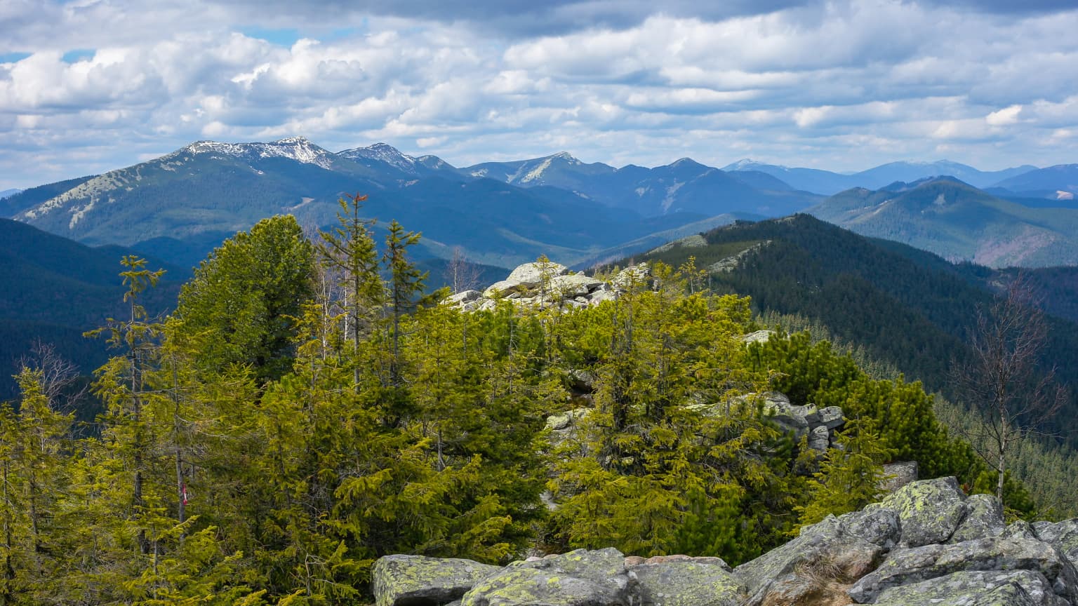
Boikivshchyna is best known for its protection of Carpathian montane conifer forests in the Eastern Beskids, a region characterized by temperate forest ecosystems that extend across eastern Romania and western Ukraine. The park encompasses the headwaters of the Stryi River and preserves the upper Dniester valley landscape. Its territory includes Pikui, the highest mountain in Lviv Oblast, offering alpine terrain above the tree line. The area is noted for its forest cover dominated by Norway spruce and European silver fir, representing some of the most intact coniferous forest communities in the Ukrainian Carpathians.

Panoramic landscape showing snow-capped mountain peaks in the distance, forested hills and rocky outcrops in the foreground, under a partly cloudy sky
Panoramic view of snow-capped mountain peaks in Boikivshchyna National Nature Park with forested hills in the foreground

Boikivshchyna National Nature Park history and protected-area timeline

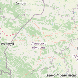
Boikivshchyna National Nature Park was officially established on April 11, 2019, when President Petro Poroshenko signed Presidential Decree No. 130/2019, creating the protected area in the Carpathian region of Lviv Oblast. The park was originally situated within Turka Raion, which was abolished during Ukrainian administrative reforms in 2020, with its territory subsequently incorporated into Sambir Raion. The decree mandated the development of a management plan for the park, the allocation of approximately 10,623 hectares of land for permanent use, and the preparation of organizational and boundary documentation between 2019 and 2021. The park was created with the explicit purpose of preserving the genetic, species, and landscape diversity of the Ukrainian Carpathians, recognizing the ecological importance of this mountain region for biodiversity conservation and ecosystem services.

Boikivshchyna National Nature Park landscape and geographic character

The terrain of Boikivshchyna National Nature Park is characterized by the mountainous topography typical of the Carpathian Beskids, with elevations ranging from approximately 400 meters in the lower valleys to over 1,700 meters at the summit of Pikui, the highest point in Lviv Oblast. The landscape consists of steep mountain slopes carved by glacial valleys, with the forest-covered ridges forming the watersheds between the Stryi River basin and other tributaries of the Dniester system. The Vododilnyi Range traverses the park area, providing the backdrop for the upper Dniester valley. The combination of elevation gradient, aspect variations, and valley morphology creates a diverse landscape of forest-covered slopes, rocky outcrops, and riparian corridors along the mountain streams. The Stryi River originates within the park boundaries, fed by springs and small tributaries descending from the higher terrain.

Boikivshchyna National Nature Park ecosystems, habitats, and plant life

Boikivshchyna lies within the Carpathian montane conifer forests ecoregion, a temperate forest ecosystem that dominates the mountainous areas of the Carpathian Mountains across multiple countries. The park's forests are primarily composed of Norway spruce and European silver fir, forming dense coniferous stands across the mountain slopes and valleys. These forest communities represent some of the more intact examples of Carpathian montane forests in Ukraine. The park supports more than 30 species of herbaceous plants, including rare species such as common clubmoss, hairy-fruited aconite, perennial honesty, smooth pea, and snowdrop. The vegetation zonation reflects the elevation gradient, with montane forests giving way to subalpine communities at higher elevations and riparian vegetation along watercourses.

Boikivshchyna National Nature Park conservation status and protection priorities

The establishment of Boikivshchyna National Nature Park represents Ukraine's effort to protect significant portions of its Carpathian forest ecosystems within a formal protected area framework. The park falls under IUCN Category II, reflecting its designation as a national park focused on ecosystem conservation and protection of natural landscapes. The Carpathian montane conifer forests are recognized as an important ecoregion for biodiversity, hosting species with both European and more restricted Carpathian distributions. The park contributes to the protection of watershed areas that feed into the Dniester River system, providing ecosystem services related to water regulation and soil conservation in the mountain catchments. The inclusion of forest lands previously under various management regimes into a coordinated protected area aims to ensure more consistent conservation of these mountain forest ecosystems.

Boikivshchyna National Nature Park cultural meaning and human context

The park is named for the Boikivshchyna region, a historical cultural region in the Carpathian foothills of western Ukraine. This area has been traditionally inhabited by Boiky, an ethnic subgroup of Ukrainians known for their distinct cultural traditions and pastoral land-use practices in the mountain and foothill zones. The landscape has been shaped by centuries of human activity, including seasonal grazing and forest resource use, though the core mountain areas maintained significant natural cover. The park's territory spans across administrative boundaries, with portions in both Lviv Oblast and Zakarpattia Oblast, reflecting the geographic continuity of the Carpathian landscape beyond modern political divisions.

Top sights and standout views in Boikivshchyna National Nature Park

The park protects Pikui, the highest mountain in Lviv Oblast, offering the most elevated terrain within the protected area with alpine character above the tree line. The source of the Stryi River is accessible via maintained walking trails within the park, providing visitors with the opportunity to visit one of the principal Carpathian rivers at its origin. The extensive spruce and fir forests represent some of the finest examples of Carpathian montane conifer forests in the region. The combination of high mountain peaks, forest-covered valleys, and watershed headwaters creates a coherent mountain landscape that exemplifies the Carpathian Beskids character.

Best time to visit Boikivshchyna National Nature Park

The Carpathian region experiences distinct seasons that affect visit conditions throughout the year. Summer months from June through August offer the warmest conditions for hiking and feature the most accessible trail conditions, with forest foliage providing shade along mountain paths. Autumn brings colorful foliage displays as the coniferous and deciduous species change, creating scenic landscapes within the forest. Winter transforms the park into a snowy mountain environment suitable for winter recreation but with more challenging access conditions. Spring allows observation of early flowering plants as snow retreats from lower elevations, though trail conditions may remain wet or muddy during the snowmelt period.

Park location guide

Geography guide, regional context, and park location map for Boikivshchyna National Nature Park

Boikivshchyna National Nature Park park geography, regions, and map view in Ukraine
Understand where Boikivshchyna National Nature Park sits in Ukraine through a broader geographic reading of the surrounding landscape, nearby location context, and its mapped position within the national park landscape.

How Boikivshchyna National Nature Park fits into Ukraine

Ukraine is a sovereign nation in Eastern Europe, bordered by Russia, Belarus, Poland, Slovakia, Hungary, Romania, Moldova, and the Black Sea. It is the second-largest country in Europe by area. Kyiv is the capital and largest city, followed by Kharkiv, Odesa, and Dnipro. The official language is Ukrainian. Ukraine has a population of approximately 32.9 million and operates as a unitary semi-presidential republic.

Wider geography shaping Boikivshchyna National Nature Park in Ukraine

Ukraine occupies 603,628 km² in Eastern Europe, making it the second-largest country in Europe. It shares borders with Russia, Belarus, Poland, Slovakia, Hungary, Romania, and Moldova. The country has a southern coastline along the Black Sea and Sea of Azov. The terrain includes plains, steppes, and the Carpathian Mountains in the west.

Map view of Boikivshchyna National Nature Park

Use this park location map to pinpoint Boikivshchyna National Nature Park in Ukraine, understand its exact geographic position, and read its mapped placement within the surrounding landscape more clearly.

Pigeon | © OpenStreetMap contributors

Location context for Boikivshchyna National Nature Park

Lviv Oblast

Discover the diverse alpine terrain, coniferous forests, and watershed habitats of the Eastern Beskids through comprehensive imagery.

Boikivshchyna National Nature Park Photos: Explore Carpathian Mountain Landscapes
Browse an extensive gallery of Boikivshchyna National Nature Park photos, showcasing its distinctive Carpathian mountain landscapes, dense coniferous forests, and diverse valley habitats in western Ukraine. These protected area views provide essential visual context, helping users understand the park's unique ecological character and its significance within the Eastern Beskids region.

Panoramic landscape showing snow-capped mountain peaks in the distance, forested hills and rocky outcrops in the foreground, under a partly cloudy sky

Park atlas

Discover additional Carpathian mountain parks and protected landscapes across Lviv Oblast and western Ukraine, building on the unique ecology of Boikivshchyna.

Explore More National Parks and Protected Areas Near Boikivshchyna National Nature Park
Explore other national parks and protected areas in Ukraine's Carpathian Mountains and the Lviv Oblast region, extending your discovery beyond Boikivshchyna National Nature Park. Compare diverse forest ecosystems, alpine landscapes, and watershed protection areas, providing a comprehensive understanding of regional conservation through mapped park geography.
National parkUkraine

Skole Beskids National Nature Park: Protected Landscape Atlas and Geographic Context in Ukraine

Explore the mapped boundaries and regional geography of this Ukrainian national park.

Delve into the specifics of Skole Beskids National Nature Park, a designated national park contributing to Ukraine's protected lands. This detail page offers a structured atlas view, focusing on the park's geographic positioning, its mapped natural landscape features, and its significance within the regional context. Understand the core identity of this protected area through detailed geographic and landscape data, enabling focused map exploration.

Area
357 km²
Established
1999
IUCN
II
Relief
Mountain
Watercolor illustration of a mountainous landscape with forests, lakes, and rolling hills under a light sky
National parkUkraine

Uzh National Nature Park: Primeval Beech Forests and Protected Landscape in Ukraine

Explore its mapped boundaries and Carpathian geography.

Uzh National Nature Park, a protected national park in Ukraine's Carpathian Mountains, safeguards a crucial segment of the Primeval Beech Forests of the Carpathians, a UNESCO World Heritage site. This atlas-focused exploration reveals the park's mapped terrain, defined by river valleys and ancient forest ecosystems, offering essential geographic context for this significant protected landscape. Discover the natural heritage preserved within its boundaries, showcasing exceptional biodiversity and the unique character of the Eastern Carpathians.

Area
391.593 km²
Established
1999
IUCN
II
National parkSubcarpathian Voivodeship

Bieszczady National Park: A Protected Landscape of the Eastern Carpathians

Explore mapped terrain, alpine meadows, and old-growth forests.

Discover Bieszczady National Park, a significant national park located in the Subcarpathian Voivodeship of Poland, within the Eastern Carpathian mountain range. This protected area is renowned for its vast expanses of old-growth beech forests, the characteristic połoniny alpine meadows, and its status as a UNESCO World Heritage Site, underscoring its global conservation importance. The park's wild character and dramatic mountain geography make it a key destination for atlas-driven exploration of protected landscapes.

Area
292.02 km²
Established
1973
IUCN
II
Relief
Mountain
National parkZakarpattia Oblast

Synevyr National Nature Park: National Park Protected Landscape in Zakarpattia Oblast

Mapped geographic context and protected area identity

Delve into Synevyr National Nature Park, a designated national park situated in the diverse geography of Zakarpattia Oblast, Ukraine. This page provides essential atlas-driven context, detailing the park's mapped boundaries and its significance as a protected landscape within the Carpathian region. Understand its unique place in Ukraine's network of natural areas and explore its regional geographic setting for a comprehensive overview.

Area
404 km²
Established
1974
Relief
Mountain
Climate
Temperate
National parkZakarpattia Oblast

Zacharovanyi Krai National Nature Park: Protected Landscape Atlas Entry

National park within Zakarpattia Oblast, Ukraine

Navigate Zacharovanyi Krai National Nature Park, a designated national park offering vital insights into protected landscapes and regional geography. This entry provides core information about the park's protected area status and its geographic setting within Zakarpattia Oblast, essential for structured atlas discovery and understanding the mapped natural terrain of western Ukraine.

Area
61.01 km²
Established
2009
IUCN
II
Relief
Mountain
National parkIvano-Frankivsk Oblast

Syniohora National Nature Park: Protected Carpathian Landscape and Geographic Context

Explore the mapped terrain and protected area boundaries within the Gorgany mountains.

Syniohora National Nature Park, located in Ivano-Frankivsk Oblast, is a vital protected area safeguarding a significant portion of the Gorgany mountain massif. This park offers a unique opportunity to explore the mapped geography and natural landscape characteristic of the Ukrainian Carpathians. Its establishment as a national park underscores the importance of preserving the region's mountain terrain, protected forest ecosystems, and distinctive natural heritage for structured geographic discovery.

Area
108.66 km²
Established
2009
IUCN
II
Scope
Terrestrial
National parkLviv Oblast

Yavoriv National Nature Park: Protected Landscape and Regional Geography in Lviv Oblast

Mapped protected area boundaries and natural terrain context.

Yavoriv National Nature Park is a designated national park within Lviv Oblast, Ukraine. This page provides detailed geographic information, focusing on the park's protected landscape identity and its mapped terrain. Understanding its location in Western Ukraine, near the Carpathian gateway, offers valuable context for atlas-based exploration of protected areas and natural features within the region.

Area
71.08 km²
Established
1998
IUCN
II
Relief
Highland
Watercolor illustration showing a landscape with rolling hills, green trees, and distant mountains under a light sky
National parkSubcarpathian Voivodeship

Magura National Park: Mapped Protected Landscape & Carpathian Geography Atlas

Explore unique sandstone formations and mapped natural terrain.

Magura National Park, located in the Subcarpathian Voivodeship of Poland, offers a rich focus for protected-area exploration and geographic discovery. This national park is distinguished by its dramatic sandstone rock formations, forested Carpathian ridges, and its ecological importance as a transitional zone. Users engaging with Magura National Park can examine its mapped boundaries, understand its specific landscape context, and appreciate its role within the broader regional geography.

Area
194.39 km²
Established
1995
IUCN
II
Visitors
40K annual

Common questions about visiting, size, designation, and location context for Boikivshchyna National Nature Park

Boikivshchyna National Nature Park FAQs for park facts, access, geography, and protected area context
Find quick answers about Boikivshchyna National Nature Park, including protected-area facts, park geography, trail and visitor context, and how the park fits into its surrounding country and regional landscape.
MoriAtlas Explorer

Continue Your Protected Areas Search Across the Global Atlas

Deepen your exploration by continuing the structured search for national parks and protected areas worldwide. Utilize the comprehensive filtering capabilities to compare different conservation landscapes and refine your understanding of global park geography. Discover more about the distribution and characteristics of protected natural areas.

Global natural geography