

Mori Atlas logo
National parkCocoparra National Park

Discover the mapped geography and distinct semi-arid terrain of this important national park.

Cocoparra National Park: A Rugged Protected Landscape in Australia's Riverina Region

Cocoparra National Park, situated in New South Wales' Riverina region, represents a significant protected natural area. This national park encompasses approximately 8,357 hectares of unique semi-arid woodland and rugged hill country, distinguished by landmarks like Bingar Mountain and Brogden Mountain. Its landscape offers a stark visual contrast to the surrounding flat agricultural plains, characterized by rocky sandstone ridges and diverse native flora. As an Important Bird Area, Cocoparra National Park plays a crucial role in conserving avian populations within its distinctive inland terrain.

National ParkNew South WalesSemi-arid LandscapeImportant Bird AreaProtected WoodlandHill Country

Cocoparra National Park

National park

Park overview

Structured park overview, official facts, and landscape profile for Cocoparra National Park

Cocoparra National Park park facts, protected area profile, and essential visitor context

Review the core facts for Cocoparra National Park, including designation, size, terrain, visitor scale, habitats, and operating context in one park-focused overview.

About Cocoparra National Park

Cocoparra National Park represents a significant protected area in the semi-arid interior of New South Wales, providing sanctuary for native wildlife and preserving a distinctive landscape character that contrasts sharply with the surrounding agricultural plains of the Riverina. The park's location, approximately 25 kilometres northeast of Griffith and 457 kilometres southwest of Sydney, places it within one of Australia's most productive farming regions, making the protected hill country and woodland of Cocoparra an important ecological refuge. The terrain is characterized by a series of low but rugged hills that break the otherwise flat landscape, with rocky sandstone ridges and steep-sided valleys supporting vegetation communities adapted to the semi-arid conditions. The park's name comes from the Aboriginal word "cocupara," referring to the kookaburra, indicating the long human association with this landscape. Adjacent to the national park to the north lies the Cocoparra Nature Reserve, which was dedicated in 1963 and together with the national park forms a contiguous protected area complex that enhances habitat connectivity and conservation effectiveness in the region.

Quick facts and research context for Cocoparra National Park

Cocoparra National Park encompasses 8,357 hectares (20,650 acres) of semi-arid terrain in inland New South Wales. The park features prominent hill formations, with Bingar Mountain reaching 455 metres and Brogden Mountain at 390 metres above sea level. The area experiences a semi-arid climate and supports vegetation communities including wattle, orchids, ironbark, and blue-tinged cypress pines. The underlying geology consists of Upper Devonian sandstones, siltstones, and conglomerates. The park contains day-use picnic areas and a campground at Woolshed Flat.

Protection and recognition

Documenting terrestrial boundary frameworks and historical conservation status records.

Official Protection Status and Protected Area Designation of Cocoparra National Park

National park atlas records track the formal terrestrial protection status and environmental designation history of Cocoparra National Park since its establishment in 1969. Understanding verified conservation frameworks helps geographers and researchers map the historical protection levels of regional ecosystems.

Protection details

Protection scope
Terrestrial
Designated year
1969
Transboundary protection
No
Park context

Deeper park guide and search-rich context for Cocoparra National Park

Cocoparra National Park history, landscape, wildlife, and travel context

Explore Cocoparra National Park through its history, landscape character, ecosystems, wildlife, conservation priorities, cultural context, and seasonal travel timing in a structured park guide built for atlas discovery and search intent.

Why Cocoparra National Park stands out

Cocoparra National Park is best known for its status as an Important Bird Area, recognized by BirdLife International for supporting significant populations of the near-threatened painted honeyeater, with up to 50 individuals recorded in the Binya-Cocoparra area, as well as the distinctive diamond firetail. The park is also notable for its rugged hill country rising from the flat Riverina plains, offering a distinctive semi-arid landscape character within a region that is predominantly agricultural. The combination of rocky sandstone ridges, woodland habitats, and isolated hilltop vegetation creates ecological diversity unusual for this part of inland New South Wales.
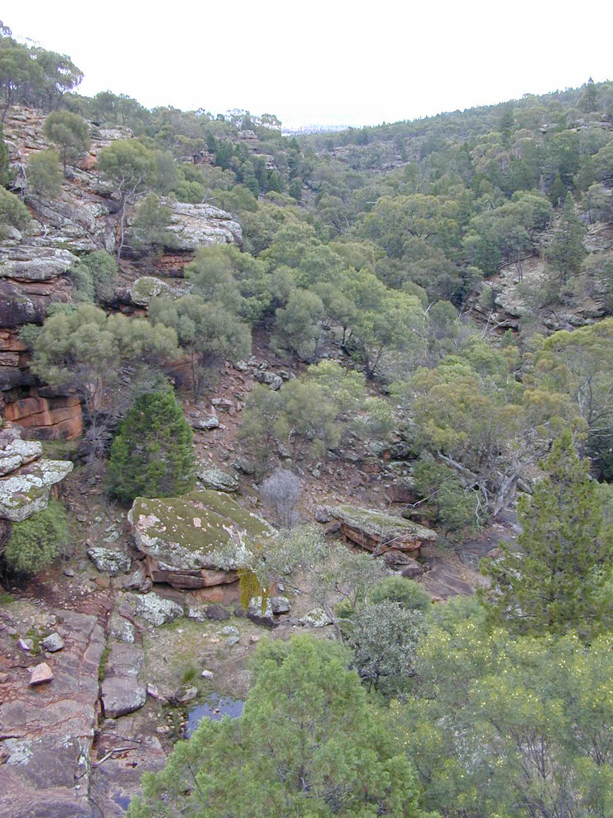
Rocky valley landscape with scattered trees, red rock formations, and a small creek
Valley view within Cocoparra National Park showing rocky terrain and Store Creek

Cocoparra National Park history and protected-area timeline

Cocoparra National Park was officially gazetted on 3 December 1969, establishing formal protected area status for this semi-arid hill country in the Riverina region of New South Wales. The adjacent Cocoparra Nature Reserve, which shares a boundary with the national park to the north, was dedicated earlier in 1963 and covers an additional 4,647 hectares, creating a combined protected area of significant scale. The establishment of the park reflected growing recognition in the late 1960s of the need to preserve representative examples of New South Wales' diverse terrestrial environments, including the semi-arid woodland and hill country of the inland regions. The park's name derives from the Aboriginal term "cocupara," which translates to kookaburra in English, preserving the indigenous heritage and naming tradition of the region.

Cocoparra National Park landscape and geographic character

The landscape of Cocoparra National Park is defined by a prominent range of hills that rise abruptly from the surrounding flat agricultural plains of the Riverina. Bingar Mountain reaches 455 metres above sea level, while Brogden Mountain stands at 390 metres, providing the most elevation change in an otherwise uniformly flat region. The hills are characterized by rocky sandstone ridges, steep-sided valleys, and exposed rock outcrops. The underlying geology comprises Upper Devonian sandstones, siltstones, and conglomerates, representing ancient sedimentary formations dating back hundreds of millions of years. The combination of rugged hill terrain with the semi-arid surrounding plains creates a landscape of strong visual contrast, where the park's dark timbered ridges stand out against the lighter-coloured farmland that dominates the broader region.

Cocoparra National Park ecosystems, habitats, and plant life

The semi-arid climate of Cocoparra National Park shapes distinctive vegetation communities adapted to relatively low rainfall and variable temperatures. The park supports woodland formations dominated by wattle (Acacia species) and ironbark trees, with an understory that includes numerous orchid species. Blue-tinged cypress pines (Callitris) add to the characteristic vegetation profile, forming dense stands on some ridgelines and slopes. The rugged terrain creates multiple microhabitats, from rocky exposed ridges to shaded valleys, supporting plant species with varying moisture and sun exposure requirements. The semi-arid woodland environment, while less biodiverse than tropical or temperate forests, supports specialized species adapted to these conditions and provides important habitat connectivity in a landscape largely transformed by agriculture.

Cocoparra National Park wildlife and species highlights

Cococoparra National Park is recognized internationally for its birdlife significance, with the Binya-Cocoparra area designated as an Important Bird Area by BirdLife International due to the presence of species of conservation concern. The park supports a relatively large population of the near-threatened painted honeyeater, with up to 50 individuals recorded in the area, making it one of the more significant populations of this species in New South Wales. The diamond firetail, a striking small finch species, is also present in good numbers. These species are associated with the semi-arid woodland and shrubland habitats found within the park. The rocky hill country and woodland environments provide nesting sites, feeding resources, and shelter for a range of bird species, making the park an important habitat in the otherwise heavily cleared Riverina agricultural landscape.

Cocoparra National Park conservation status and protection priorities

Cocoparra National Park plays an important conservation role in the Riverina region of New South Wales, preserving semi-arid woodland and hill country habitats that have been largely cleared for agriculture across the broader landscape. The park's designation as an Important Bird Area by BirdLife International highlights its significance for conservation, particularly for the near-threatened painted honeyeater. The combined protected area complex formed by the national park and adjacent Cocoparra Nature Reserve provides substantial habitat for native species and supports ecological processes in a region where remaining natural vegetation is highly fragmented. The preservation of the park's rocky ridges, woodland, and riparian corridors contributes to biodiversity conservation in an area where the semi-arid environment and historical land clearing have significantly reduced native habitat extent.

Cocoparra National Park cultural meaning and human context

The Cocoparra area holds indigenous heritage significance, as evidenced by the park's name deriving from the Aboriginal term "cocupara," meaning kookaburra in the local indigenous language. This naming connection preserves the cultural association between the landscape and the traditional custodians of the land. The semi-arid hills and woodlands of the Riverina region have been inhabited by Aboriginal peoples for thousands of years, with the Cocoparra hills likely serving as important reference points, resource areas, and cultural sites within the broader indigenous landscape of the region. The preservation of the Aboriginal place name in the national park's title maintains this cultural connection as part of the park's identity.

Top sights and standout views in Cocoparra National Park

The distinctive hill country of Cocoparra National Park, rising from the flat Riverina plains, provides a dramatic landscape contrast that defines the park's character. Bingar Mountain and Brogden Mountain offer elevated viewpoints over the surrounding agricultural landscape. The semi-arid woodland, with its ironbark, wattle, and cypress pine communities, creates a characteristic Australian inland scenery. The Important Bird Area designation highlights the park's significance for conservation of the near-threatened painted honeyeater and diamond firetail. The adjacent Cocoparra Nature Reserve expands the protected area, creating a larger conservation complex. The park provides accessible semi-arid nature experiences with picnic areas and camping facilities at Woolshed Flat.

Best time to visit Cocoparra National Park

The best time to visit Cocoparra National Park is during the cooler months of autumn and spring, when temperatures are more comfortable for exploring the hill tracks and woodland areas. Winter months (June to August) offer mild daytime temperatures and typically clear skies, making it a pleasant season for walking and wildlife observation, though nights can be cold. Summer (December to February) in this semi-arid region can bring very hot conditions, so early morning or late afternoon visits are advisable during this period. The park's vegetation and birdlife can be observed year-round, though spring flowering of orchids and wattles adds particular seasonal interest.
Monthly climate preview

Compare long term monthly temperature patterns and average precipitation in the Riverina.

Annual Climate Profile and Weather by Month for Cocoparra National Park

Long-term weather records at the representative elevation of 176 meters show extreme hot peaks exceeding 40 degrees alongside a dry annual precipitation rhythm. Accessing the complete monthly climatology dataset reveals detailed multi-decade temperature spreads and precipitation variations across the Riverina.
Annual mean17 °C
9 °C27 °C
Jan27°
Feb26°
Mar22°
Apr17°
May13°
Jun10°
Jul
Aug10°
Sep13°
Oct17°
Nov21°
Dec24°
Warmest month
January

27 °C

Coolest month
July

8.6 °C

Wettest month
February

1.4 mm/day

Driest month
April

0.8 mm/day

Park location guide

Geography guide, regional context, and park location map for Cocoparra National Park

Cocoparra National Park park geography, regions, and map view in Australia

Understand where Cocoparra National Park sits in Australia through a broader geographic reading of the surrounding landscape, nearby location context, and its mapped position within the national park landscape.

How Cocoparra National Park fits into Australia

Australia is a constitutional monarchy and federal parliamentary democracy comprising six states and ten territories. With a population of nearly 28 million, it is one of the world's most urbanised countries, with most people concentrated on the eastern seaboard. The country has a high Human Development Index and is known for its cultural diversity, ancient Aboriginal heritage, and unique wildlife.

Wider geography shaping Cocoparra National Park in Australia

Australia occupies the entire Australian continent, the island of Tasmania, and numerous smaller islands. It is the world's flattest and driest inhabited continent, featuring vast deserts in the interior (the Outback), tropical rainforests along the eastern coast, and a coastline bordering the Indian and Pacific Oceans.

Map view of Cocoparra National Park

Use this park location map to pinpoint Cocoparra National Park in Australia, understand its exact geographic position, and read its mapped placement within the surrounding landscape more clearly.

Pigeon | © OpenStreetMap contributors

Location context for Cocoparra National Park

New South WalesRiverina

View the iconic hill country and semi-arid woodland scenery, offering insight into the park's distinct protected landscape within the Riverina region.

Cocoparra National Park Photos: Explore Rugged Hill Landscapes, Semi-arid Woodland, and Protected Habitats

Explore a visual collection showcasing the rugged hill country, sandstone ridges, and diverse semi-arid woodland habitats unique to Cocoparra National Park. These curated images offer essential insights into the protected area's distinct landscape character, illustrating its dramatic elevation, bird environments, and visual contrast with the surrounding flat Riverina plains.

Rocky valley landscape with scattered trees, red rock formations, and a small creek

Park atlas

Trace the regional spread of protected landscapes and compare adjacent park geography in the Riverina.

Explore Other National Parks and Protected Areas Near Cocoparra National Park

Discover national parks and protected areas similar to Cocoparra National Park, tracing the unique semi-arid woodland and hill country landscapes across New South Wales. Compare the geographic context of these conservation sites, mapping their regional spread within the Riverina and understanding their distinct ecological features.
Nature reserveNew South Wales
About 14 km away#1 closest

Northwest

Pulletop Nature Reserve: Mapping the Mallee Woodlands of New South Wales

Protected semi-arid landscapes and malleefowl habitat

Pulletop Nature Reserve stands as a preserved fragment of the extensive mallee woodland that once dominated inland New South Wales. Within the Cobar Peneplain, this nature reserve offers a look at dry-country ecosystems, featuring diverse eucalypt species and habitat for the malleefowl in a flat, undisturbed geographic setting.

Area
1.45 km²
Established
1963
IUCN
Ia
Relief
Lowland
National parkNew South Wales
About 56 km away#2 closest

South

Murrumbidgee Valley National Park: National Park with Mapped Protected Boundaries in New South Wales

Regional geography and landscape context for this protected area.

Murrumbidgee Valley National Park is recognized as a national park, offering critical insights into protected land distribution within New South Wales. This destination facilitates an atlas-style exploration of its geographic identity, mapped boundaries, and its role as a defined natural landscape within the broader region. Understanding this park's protected status and geographic placement is key for detailed map-based discovery.

Area
477.03 km²
Established
2010
IUCN
II
Relief
Lowland
Nature reserveNew South Wales
About 81 km away#3 closest

East

Charcoal Tank Nature Reserve: Mapped Protected Landscapes and Regional Geography in New South Wales

Critical mallee-broombush woodland and avian refuge in a fragmented agricultural corridor

Charcoal Tank Nature Reserve stands as a vital 86-hectare protected site in central western New South Wales, preserving rare mallee and mallee-broombush woodland that has been largely cleared elsewhere. This documentation maps the reserve's unique position within the regional agricultural matrix, detailing its significance as an long-studied avian habitat and a sanctuary for native species struggling in a fragmented, semi-arid environment.

Area
0.86 km²
Established
1966
IUCN
Ia
Relief
Lowland
National parkNew South Wales
97 km away#4 closest

Southwest

Oolambeyan National Park National Park: Discover its Mapped Geography and Protected Landscape

Explore the protected area and regional context of New South Wales.

Delve into Oolambeyan National Park, a key national park within New South Wales, Australia. This entry provides essential geographic context, detailing the park's mapped boundaries and its identity as a protected landscape. It serves as a foundation for understanding the park's contribution to the regional atlas and offers a distinct perspective on the natural geography of the area.

Area
222.31 km²
Established
2001
IUCN
II
Access
Moderate access
Nature reserveNew South Wales
About 107 km away#5 closest

Southeast

Ingalba, Big Bush and Pucawan Nature Reserves: Regional Geography and Protected Woodland Map

Inland New South Wales conservation complex within the Lachlan Fold Belt

These three nature reserves function as one of the most substantial surviving remnants of mugga ironbark and western grey box woodland in southern inland New South Wales. Located west of Temora, the reserves protect forty-nine square kilometres of distinct woodland and dry heathland communities that provide essential habitat corridors across a heavily cleared agricultural region. The mapping highlights the unique topography and geological variety that sustains this protected landscape.

Area
49.27 km²
IUCN
Ia
Relief
Upland
Climate
Temperate
Nature reserveNew South Wales
About 118 km away#6 closest

South

Lake Urana Nature Reserve: Geographic Atlas and Protected Area Mapping in Riverina

Inland salt-lake systems and dry box-pine woodland habitats

Lake Urana Nature Reserve functions as a representative protected zone within the Riverina region of New South Wales. The landscape transitions from the ephemeral salt-lake shoreline to native box-pine forests. This atlas entry details the protected boundaries and ecological characteristics of these arid-adapted inland plant communities and their role within the wider plains habitat network.

Area
3.02 km²
Established
1996
IUCN
Ia
Relief
Lowland
Nature reserveNew South Wales
About 123 km away#7 closest

East

Boginderra Hills Nature Reserve: Protected Granite Landscapes in New South Wales

An ecological map of the Riverina woodland refuge.

Boginderra Hills Nature Reserve protects a distinct granite ridge that remains largely intact amidst the heavily modified plains of the Riverina. This site functions as a strictly managed conservation area, preserving a mosaic of native eucalypt and cypress pine communities that provide essential habitat for regional woodland bird species and other native fauna.

Area
7.56 km²
Established
1982
IUCN
Ia
Relief
Upland
National parkNew South Wales
135 km away#8 closest

Northwest

Willandra National Park: National Park Protected Landscape & Geographic Context

Discover mapped boundaries within this New South Wales protected area.

Willandra National Park is a designated national park in New South Wales, Australia, offering focused opportunities for understanding protected landscapes. This entry provides essential geographic context and highlights the importance of mapped park boundaries for atlas-driven exploration. Users can engage with the park's specific landscape identity and its contribution to the broader regional geography of New South Wales through structured data.

Area
193.86 km²
Established
1972
IUCN
II
Relief
Lowland

Common questions about visiting, size, designation, and location context for Cocoparra National Park

Cocoparra National Park FAQs for park facts, access, geography, and protected area context

Find quick answers about Cocoparra National Park, including protected-area facts, park geography, trail and visitor context, and how the park fits into its surrounding country and regional landscape.
MoriAtlas Explorer

Continue Your Protected Areas Search Across the Global Atlas

Deepen your exploration by continuing the structured search for national parks and protected areas worldwide. Utilize the comprehensive filtering capabilities to compare different conservation landscapes and refine your understanding of global park geography. Discover more about the distribution and characteristics of protected natural areas.

Global natural geography