Why Murrumbidgee Valley National Park stands out
Murrumbidgee Valley National Park is best known for protecting the world's largest continuous river red gum forest, a defining feature of the Murrumbidgee floodplain. The park preserves critically endangered river red gum woodlands and associated wetlands that represent some of the most threatened ecosystems in Australia. These forested wetlands occur only in riverine corridors and floodplains on rich alluvial soils, making them rare and ecologically significant. The park also serves as a carbon sequestration stronghold in a heavily cleared agricultural region.
Murrumbidgee Valley National Park history and protected-area timeline
Murrumbidgee Valley National Park was established on July 1, 2010, making it a relatively recent addition to Australia's national park system. The park was created through the incorporation of several former state forests that had been managed for timber production but were identified as having high conservation value. The establishment of the national park reflected a growing recognition that the river red gum forests of the Murrumbidgee floodplain required formal protection as national park estate rather than continued management as production forests. The creation of the park also acknowledged the ecological significance of these forests as some of the last substantial remnants of a once extensive ecosystem that has been largely cleared from the region. The park was incorporated into the NSW national parks system and is managed by the NSW National Parks and Wildlife Service.
Murrumbidgee Valley National Park landscape and geographic character
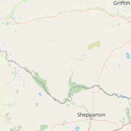
The landscape of Murrumbidgee Valley National Park is defined by the Murrumbidgee River and its associated floodplain, a flat to gently undulating terrain characterized by river channels, permanent waterways, and seasonal wetlands. The park consists of narrow, elongated precincts that follow the river corridor, with the river red gum forests forming dense stands along the water's edge and extending onto the adjacent floodplains. The alluvial soils of the floodplain are rich and fertile, historically supporting extensive woodlands before much of the surrounding landscape was cleared for agriculture. The terrain is relatively low-lying, with subtle elevation changes between the river channels and the surrounding plains. The park contains a mix of permanently inundated forest, periodically flooded wetlands, and drier woodland fringes that transition into the surrounding agricultural countryside.
Murrumbidgee Valley National Park ecosystems, habitats, and plant life
The river red gum forests of Murrumbidgee Valley National Park represent a distinctive Australian ecosystem type found along inland river systems in southeastern Australia. These forests occur along river corridors and floodplains where the combination of regular flooding and fertile alluvial soils supports dense stands of Eucalyptus camaldulensis, the river red gum. The park also protects wetlands, woodlands, and grasslands that together form a complex mosaic of habitats dependent on the flood regime of the Murrumbidgee River. These ecosystems are widely acknowledged as among the most threatened in Australia because they occur on productive alluvial soils that have been extensively cleared for agriculture. The river red gum forests contribute valuable ecosystem services, including carbon sequestration, in a bioregion that has been heavily modified by human activity. The floodplain ecosystem depends on periodic flooding to maintain its ecological character, though natural hydrological patterns have been significantly altered by water extraction and irrigation infrastructure in the catchment.
Murrumbidgee Valley National Park wildlife and species highlights
The river red gum forests and wetlands of Murrumbidgee Valley National Park support a range of wildlife adapted to Australia's inland river environments. The permanent water bodies and seasonally inundated wetlands provide habitat for waterbirds, including species that rely on the floodplain for breeding and foraging. The hollows within mature river red gums offer nesting sites for hollow-nesting birds and arboreal mammals. The forest canopy supports a variety of bird species, while the understory and ground layer provide resources for mammals, reptiles, and invertebrates. The wetlands are particularly important for migratory waterbirds that move through the Murray-Darling Basin, utilizing the flooded habitats as feeding and resting areas during their seasonal movements. The park's position within the Murrumbidgee River corridor provides connectivity for wildlife movement through a largely cleared agricultural landscape.
Murrumbidgee Valley National Park conservation status and protection priorities
The protection of Murrumbidgee Valley National Park is significant because it conserves some of the last substantial remnants of river red gum forest and associated wetlands in the Murray-Darling Basin. These ecosystems are among the most threatened in Australia, occurring only in narrow riverine corridors and floodplains on soils that have been highly valued for agriculture and therefore extensively cleared. The inclusion of these forested wetlands in the national park system represents recognition of their ecological importance and their vulnerability to ongoing environmental pressures. The park plays a critical role in preserving biodiversity in a bioregion that has been heavily transformed by agricultural development, providing refuge for species dependent on river red gum woodland and wetland habitats. The carbon sequestration capacity of these forests adds to their environmental significance in the context of climate change mitigation.
Murrumbidgee Valley National Park cultural meaning and human context
The Murrumbidgee River holds cultural significance for Aboriginal peoples who have lived along its banks for thousands of years. The Riverina region was traditionally inhabited by various Aboriginal groups who utilized the river's resources for food, water, and cultural practices. The floodplain and its associated wetlands and forests would have supported traditional hunting and gathering activities. While the specific Aboriginal connections to the land now within the national park are not extensively documented in the available source material, the broader Riverina region contains Aboriginal heritage values associated with the river system. The landscape has been subject to European settlement and agricultural development since the nineteenth century, with the former state forests within the park reflecting historical timber extraction use.
Top sights and standout views in Murrumbidgee Valley National Park
The world's largest continuous river red gum forest dominates Murrumbidgee Valley National Park, a globally significant remnant of Australia's riparian woodlands. The park protects critically endangered forested wetlands that occur only on the fertile floodplains of inland river systems. Multiple precincts spread along 250 kilometres of river corridor preserve a spectrum of habitats from permanent water channels to seasonal wetlands and woodland fringes. The park serves as a biodiversity refuge in the heavily cleared Riverina agricultural region, providing habitat for waterbirds, hollow-nesting species, and woodland fauna. The conservation of these ecosystems is significant given their threatened status and their importance for ecosystem services including carbon storage.
Best time to visit Murrumbidgee Valley National Park
The best time to visit Murrumbidgee Valley National Park depends on seasonal conditions and the experience sought. The cooler months from late autumn through winter into early spring typically offer more comfortable conditions for exploring the park, with milder daytime temperatures. Spring can bring increased bird activity as waterbirds utilize the wetlands during the breeding season, and the surrounding landscape may display wildflower displays following winter rains. Summer months can be hot in the Riverina, though the river red gum forests along the waterways can provide shaded areas. Visitors interested in wildlife viewing should consider how seasonal water levels affect habitat availability, as the floodplain ecosystem responds to variations in river flow and rainfall patterns.