

Mori Atlas logo
National parkMurrumbidgee Valley National Park

Explore mapped boundaries and the regional geographic context of this New South Wales national park.

Murrumbidgee Valley National Park: National Park, New South Wales Protected Landscape & Geography

Murrumbidgee Valley National Park represents a significant protected area within New South Wales, Australia. This page provides an atlas-focused view, detailing the park's geographic setting and mapped boundaries. Understand its place within the regional landscape and how this national park contributes to the protected lands of New South Wales, offering a distinct point of geographic discovery.

River red gum forestWetlandsRiverinaNational parkAustralian protected areaFloodplain ecosystem

Murrumbidgee Valley National Park

National park

Park overview

Structured park overview, official facts, and landscape profile for Murrumbidgee Valley National Park

Murrumbidgee Valley National Park park facts, protected area profile, and essential visitor context
Review the core facts for Murrumbidgee Valley National Park, including designation, size, terrain, visitor scale, habitats, and operating context in one park-focused overview.

About Murrumbidgee Valley National Park

Murrumbidgee Valley National Park is located in the Riverina, a predominantly agricultural region in inland New South Wales. The park protects a chain of precincts spread along the Murrumbidgee River corridor, extending approximately 250 kilometres from Collingullie, some 30 kilometres west of Wagga Wagga, to the town of Hay. The national park was created to safeguard one of Australia's most ecologically significant forest types, the river red gum woodlands that once dominated the floodplain waterways of inland southeastern Australia. The park is complemented by the adjacent Murrumbidgee Valley Nature Reserve, together forming a contiguous conservation network that preserves the biological diversity of this highly modified river system. The landscape consists of narrow strips of riparian forest following the river channels, surrounded by agricultural land that has been extensively cleared for cropping and grazing. The conservation of these remaining forest fragments is critical given that the Riverina bioregion has been heavily transformed by human activity, with much of its original vegetation cleared for agriculture.

Quick facts and research context for Murrumbidgee Valley National Park

The Murrumbidgee Valley National Park occupies 477.03 square kilometres within the Riverina bioregion of New South Wales. It is administered by the NSW National Parks and Wildlife Service and was established in 2010 to protect river red gum forests, wetlands, woodlands, and grasslands. The park encompasses several former state forests that have been incorporated into the national park system. The Murrumbidgee River itself has been heavily modified by irrigation activities in the surrounding region, which has significantly altered natural flooding patterns that historically supported the floodplain ecosystem.

Park context

Deeper park guide and search-rich context for Murrumbidgee Valley National Park

Murrumbidgee Valley National Park history, landscape, wildlife, and travel context
Explore Murrumbidgee Valley National Park through its history, landscape character, ecosystems, wildlife, conservation priorities, cultural context, and seasonal travel timing in a structured park guide built for atlas discovery and search intent.

Why Murrumbidgee Valley National Park stands out

Murrumbidgee Valley National Park is best known for protecting the world's largest continuous river red gum forest, a defining feature of the Murrumbidgee floodplain. The park preserves critically endangered river red gum woodlands and associated wetlands that represent some of the most threatened ecosystems in Australia. These forested wetlands occur only in riverine corridors and floodplains on rich alluvial soils, making them rare and ecologically significant. The park also serves as a carbon sequestration stronghold in a heavily cleared agricultural region.

Murrumbidgee Valley National Park history and protected-area timeline

Murrumbidgee Valley National Park was established on July 1, 2010, making it a relatively recent addition to Australia's national park system. The park was created through the incorporation of several former state forests that had been managed for timber production but were identified as having high conservation value. The establishment of the national park reflected a growing recognition that the river red gum forests of the Murrumbidgee floodplain required formal protection as national park estate rather than continued management as production forests. The creation of the park also acknowledged the ecological significance of these forests as some of the last substantial remnants of a once extensive ecosystem that has been largely cleared from the region. The park was incorporated into the NSW national parks system and is managed by the NSW National Parks and Wildlife Service.

Murrumbidgee Valley National Park landscape and geographic character

The landscape of Murrumbidgee Valley National Park is defined by the Murrumbidgee River and its associated floodplain, a flat to gently undulating terrain characterized by river channels, permanent waterways, and seasonal wetlands. The park consists of narrow, elongated precincts that follow the river corridor, with the river red gum forests forming dense stands along the water's edge and extending onto the adjacent floodplains. The alluvial soils of the floodplain are rich and fertile, historically supporting extensive woodlands before much of the surrounding landscape was cleared for agriculture. The terrain is relatively low-lying, with subtle elevation changes between the river channels and the surrounding plains. The park contains a mix of permanently inundated forest, periodically flooded wetlands, and drier woodland fringes that transition into the surrounding agricultural countryside.

Murrumbidgee Valley National Park ecosystems, habitats, and plant life

The river red gum forests of Murrumbidgee Valley National Park represent a distinctive Australian ecosystem type found along inland river systems in southeastern Australia. These forests occur along river corridors and floodplains where the combination of regular flooding and fertile alluvial soils supports dense stands of Eucalyptus camaldulensis, the river red gum. The park also protects wetlands, woodlands, and grasslands that together form a complex mosaic of habitats dependent on the flood regime of the Murrumbidgee River. These ecosystems are widely acknowledged as among the most threatened in Australia because they occur on productive alluvial soils that have been extensively cleared for agriculture. The river red gum forests contribute valuable ecosystem services, including carbon sequestration, in a bioregion that has been heavily modified by human activity. The floodplain ecosystem depends on periodic flooding to maintain its ecological character, though natural hydrological patterns have been significantly altered by water extraction and irrigation infrastructure in the catchment.

Murrumbidgee Valley National Park wildlife and species highlights

The river red gum forests and wetlands of Murrumbidgee Valley National Park support a range of wildlife adapted to Australia's inland river environments. The permanent water bodies and seasonally inundated wetlands provide habitat for waterbirds, including species that rely on the floodplain for breeding and foraging. The hollows within mature river red gums offer nesting sites for hollow-nesting birds and arboreal mammals. The forest canopy supports a variety of bird species, while the understory and ground layer provide resources for mammals, reptiles, and invertebrates. The wetlands are particularly important for migratory waterbirds that move through the Murray-Darling Basin, utilizing the flooded habitats as feeding and resting areas during their seasonal movements. The park's position within the Murrumbidgee River corridor provides connectivity for wildlife movement through a largely cleared agricultural landscape.

Murrumbidgee Valley National Park conservation status and protection priorities

The protection of Murrumbidgee Valley National Park is significant because it conserves some of the last substantial remnants of river red gum forest and associated wetlands in the Murray-Darling Basin. These ecosystems are among the most threatened in Australia, occurring only in narrow riverine corridors and floodplains on soils that have been highly valued for agriculture and therefore extensively cleared. The inclusion of these forested wetlands in the national park system represents recognition of their ecological importance and their vulnerability to ongoing environmental pressures. The park plays a critical role in preserving biodiversity in a bioregion that has been heavily transformed by agricultural development, providing refuge for species dependent on river red gum woodland and wetland habitats. The carbon sequestration capacity of these forests adds to their environmental significance in the context of climate change mitigation.

Murrumbidgee Valley National Park cultural meaning and human context

The Murrumbidgee River holds cultural significance for Aboriginal peoples who have lived along its banks for thousands of years. The Riverina region was traditionally inhabited by various Aboriginal groups who utilized the river's resources for food, water, and cultural practices. The floodplain and its associated wetlands and forests would have supported traditional hunting and gathering activities. While the specific Aboriginal connections to the land now within the national park are not extensively documented in the available source material, the broader Riverina region contains Aboriginal heritage values associated with the river system. The landscape has been subject to European settlement and agricultural development since the nineteenth century, with the former state forests within the park reflecting historical timber extraction use.

Top sights and standout views in Murrumbidgee Valley National Park

The world's largest continuous river red gum forest dominates Murrumbidgee Valley National Park, a globally significant remnant of Australia's riparian woodlands. The park protects critically endangered forested wetlands that occur only on the fertile floodplains of inland river systems. Multiple precincts spread along 250 kilometres of river corridor preserve a spectrum of habitats from permanent water channels to seasonal wetlands and woodland fringes. The park serves as a biodiversity refuge in the heavily cleared Riverina agricultural region, providing habitat for waterbirds, hollow-nesting species, and woodland fauna. The conservation of these ecosystems is significant given their threatened status and their importance for ecosystem services including carbon storage.

Best time to visit Murrumbidgee Valley National Park

The best time to visit Murrumbidgee Valley National Park depends on seasonal conditions and the experience sought. The cooler months from late autumn through winter into early spring typically offer more comfortable conditions for exploring the park, with milder daytime temperatures. Spring can bring increased bird activity as waterbirds utilize the wetlands during the breeding season, and the surrounding landscape may display wildflower displays following winter rains. Summer months can be hot in the Riverina, though the river red gum forests along the waterways can provide shaded areas. Visitors interested in wildlife viewing should consider how seasonal water levels affect habitat availability, as the floodplain ecosystem responds to variations in river flow and rainfall patterns.
Park location guide

Geography guide, regional context, and park location map for Murrumbidgee Valley National Park

Murrumbidgee Valley National Park park geography, regions, and map view in Australia
Understand where Murrumbidgee Valley National Park sits in Australia through a broader geographic reading of the surrounding landscape, nearby location context, and its mapped position within the national park landscape.

How Murrumbidgee Valley National Park fits into Australia

Australia is a constitutional monarchy and federal parliamentary democracy comprising six states and ten territories. With a population of nearly 28 million, it is one of the world's most urbanised countries, with most people concentrated on the eastern seaboard. The country has a high Human Development Index and is known for its cultural diversity, ancient Aboriginal heritage, and unique wildlife.

Wider geography shaping Murrumbidgee Valley National Park in Australia

Australia occupies the entire Australian continent, the island of Tasmania, and numerous smaller islands. It is the world's flattest and driest inhabited continent, featuring vast deserts in the interior (the Outback), tropical rainforests along the eastern coast, and a coastline bordering the Indian and Pacific Oceans.

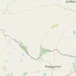
Map view of Murrumbidgee Valley National Park

Use this park location map to pinpoint Murrumbidgee Valley National Park in Australia, understand its exact geographic position, and read its mapped placement within the surrounding landscape more clearly.

Pigeon | © OpenStreetMap contributors

Location context for Murrumbidgee Valley National Park

New South Wales
Park atlas

Trace the Mapped Geography of Protected Landscapes Across New South Wales' Riverina Region

Find Related National Parks and Protected Areas Beyond Murrumbidgee Valley National Park
Browse other national parks and protected areas situated within the Riverina region and broader New South Wales, revealing diverse protected landscapes. Compare different conservation efforts and mapped terrain features across the continuous Murrumbidgee River corridor and surrounding agricultural plains.
National parkRiverina

Cocoparra National Park: Semi-Arid Hill Country and Protected Landscape in Riverina

Explore mapped geography and key natural features of this Australian national park.

Cocoparra National Park is an essential protected natural area within Australia's Riverina region, noted for its striking semi-arid landscape. The park features a prominent range of low hills, including Bingar Mountain, rising from the predominantly flat terrain. This distinctive geography, characterized by rocky sandstone ridges and characteristic woodland communities, offers valuable insights into the region's natural heritage. As an Important Bird Area, Cocoparra National Park also holds significant conservation value for its avian populations and their unique inland habitat.

Area
83.57 km²
Established
1969
IUCN
II
Relief
Mixed relief
National parkNew South Wales

Oolambeyan National Park National Park: Discover its Mapped Geography and Protected Landscape

Explore the protected area and regional context of New South Wales.

Delve into Oolambeyan National Park, a key national park within New South Wales, Australia. This entry provides essential geographic context, detailing the park's mapped boundaries and its identity as a protected landscape. It serves as a foundation for understanding the park's contribution to the regional atlas and offers a distinct perspective on the natural geography of the area.

Area
222.31 km²
Established
2001
IUCN
II
Access
Moderate access
National parkNew South Wales

Livingstone National Park: National Park Protected Landscape and Geographic Context

Mapped terrain and protected area discovery for this New South Wales park.

Investigate Livingstone National Park as a key protected natural area in New South Wales. This detail entry offers insights into its mapped boundaries, regional geographic setting, and landscape character. Explore how this national park contributes to the broader atlas of Australian protected lands and understand its distinct natural terrain through detailed geographic data.

Area
19.19 km²
Established
2001
IUCN
II
Relief
Mixed relief
National parkNew South Wales

Benambra National Park: New South Wales Protected Area and Great Yambla Range Map

Explore mapped terrain and woodland ecosystems.

Benambra National Park serves as a key protected area in New South Wales, preserving crucial white box and Red Box woodland communities against a backdrop of the Great Yambla Range's dramatic topography. This national park is significant for its role in conserving habitat for at least twelve threatened bird species and its unique geological features, including cliff faces and flat-topped peaks. Understanding the park's mapped boundaries and its place within the South West Slopes region offers valuable context for geographic discovery and the study of Australia's natural landscapes.

Area
13.99 km²
Established
2001
IUCN
II
Relief
Mixed relief
Watercolor illustration of a river landscape with green hills, trees, and pink reeds
National park

Barmah National Park National Park: World's Largest River Red Gum Forest Landscape

Explore Mapped Boundaries and Wetland Geography

Barmah National Park in Victoria, Australia, is renowned for protecting the largest river red gum floodplain forest on Earth, a globally significant Ramsar-listed wetland. This protected area's landscape is defined by majestic eucalypts bordering freshwater marshes along the Murray River. Dive into its distinct geography, mapped terrain, and the protected status of this remarkable ecosystem, offering unparalleled opportunities for understanding regional natural landscapes and conservation.

Area
285.21 km²
Established
2010
IUCN
II
Relief
Lowland
Watercolor depiction of a river, trees, and rolling hills in a landscape
National parkNew South Wales

Jindalee National Park: New South Wales National Park Protecting Cypress Pine Woodlands

Explore unique mapped terrain and regional conservation landscape.

Jindalee National Park represents a vital conservation effort in New South Wales, safeguarding remaining cypress pine woodlands and Critically Endangered grassy woodland ecosystems. Situated in the South West Slopes region, its undulating terrain and drainage lines form a distinctive natural landscape. The park's designation as a national park underscores its importance for preserving threatened species habitats and offers a focused point for atlas-driven discovery of its unique protected-area character and geographic context.

Area
10.76 km²
Established
2011
IUCN
II
Relief
Lowland
National parkNew South Wales

Woomargama National Park: National Park Protected Area with Mapped Landscape Identity

Discover the geographic context and park boundaries.

Woomargama National Park serves as a distinct entity for geographic exploration within New South Wales. As a designated national park, its protected landscape identity is integral to understanding the regional map. This profile facilitates detailed study of its position, natural terrain context, and role within Australia's network of conservation areas, providing structured data for atlas-based discovery.

Area
241.85 km²
Established
2001
IUCN
II
Relief
Upland
National park

Warby-Ovens National Park: Protected Landscape and Geographic Atlas Entry

Discover its Box-Ironbark forests and mapped regional terrain.

Warby-Ovens National Park is a protected national park situated in northeastern Victoria, Australia, covering 14,655 hectares of distinctive landscape. It is internationally recognized as an Important Bird Area, primarily for its significant Box-Ironbark forest ecosystem that supports numerous threatened woodland bird species. The park's geography features low granite hills and rolling terrain, with the Ovens River flowing through its northern section. This detail page provides structured information on its protected boundaries, natural landscape characteristics, and its place within regional geography.

Area
146.55 km²
Established
2010
IUCN
II
Relief
Upland

Common questions about visiting, size, designation, and location context for Murrumbidgee Valley National Park

Murrumbidgee Valley National Park FAQs for park facts, access, geography, and protected area context
Find quick answers about Murrumbidgee Valley National Park, including protected-area facts, park geography, trail and visitor context, and how the park fits into its surrounding country and regional landscape.
MoriAtlas Explorer

Continue Your Protected Areas Search Across the Global Atlas

Deepen your exploration by continuing the structured search for national parks and protected areas worldwide. Utilize the comprehensive filtering capabilities to compare different conservation landscapes and refine your understanding of global park geography. Discover more about the distribution and characteristics of protected natural areas.

Global natural geography