Mori Atlas logo
Nature reserveColne Estuary

Examining the complex tidal mosaic, saltmarsh boundaries, and intertidal habitats of the Essex coast

Colne Estuary Nature Reserve: A Detailed Atlas of Coastal Wetland Geography in Essex, England

(Colne Estuary Site of Special Scientific Interest)

Colne Estuary stands as a significant coastal protected area where the River Colne meets the North Sea in Essex. This site features a dynamic landscape composed of vast intertidal mudflats, expansive saltmarshes, and shingle spits that provide critical habitat for migratory waterbirds. Beyond its contemporary ecological role, the area preserves important Pleistocene geological deposits that offer insight into past climates. The region serves as a benchmark for understanding tidal coastal processes and the complex stratification of conservation-protected lands in eastern England.

estuarycoastal wetlandsaltmarshmudflatsshingle coastinternational wetland

Colne Estuary

Nature reserve

Park overview

Structured park overview, official facts, and landscape profile for Colne Estuary

Colne Estuary park facts, protected area profile, and essential visitor context

Review the core facts for Colne Estuary, including designation, size, terrain, visitor scale, habitats, and operating context in one park-focused overview.

About Colne Estuary

Colne Estuary occupies a strategic position on the Essex coast where the River Colne broadens into a tidal system before entering theNorth Sea near Brightlingsea. The protected area extends across several thousand hectares of intertidal and coastal habitat, encompassing the active channels of the estuary, broad expanses of saltmarsh, exposed mudflats, shingle ridges, and fragments of reclaimed land that now contain restored wetland features such as former gravel pits. The result is a varied and interconnected coastal landscape in which terrestrial, freshwater, and marine influences continually interact.

The site holds a remarkable concentration of overlapping conservation designations. In addition to its status as a Site of Special Scientific Interest, notified in 1989, Colne Estuary is a National Nature Reserve, a Nature Conservation Review site, a Ramsar wetland of international importance, a Special Protection Area under the European Birds Directive, a Special Area of Conservation, and a Geological Conservation Review site. This multilayered recognition reflects the site's combined ecological, ornithological, and geological significance.

Habitats across the estuary are highly diverse for a single SSSI. Saltmarsh communities fringe large sections of the tidal channels, while expansive mudflats are revealed at low tide, providing rich feeding areas for waders and wildfowl. Shingle spits and beach formations add a contrasting hard-coast element, and former gravel pits within the wider site now support freshwater and brackish wetland habitats. The Essex Wildlife Trust actively manages three areas within the site, Colne Point, Fingringhoe Wick, and Howlands Marsh, helping to maintain the variety of conditions that support the site's wildlife.

The estuary is of particular importance for birds, functioning both as a wintering area and as a staging point on migratory routes. It qualifies under international criteria for dark-bellied brent geese and black-tailed godwits, while six further species are recognized as nationally important, including little terns among the breeding birds of the site. Saltmarshes and transition zones also support rich invertebrate communities and specialised plant assemblages, with golden samphire and shrubby seablite among the notable botanical features. The presence of a peat seam at St Osyph Marsh, dated to around 4,280 years before present, adds geoarchaeological interest, and Pleistocene sections at East Mersea provide valuable evidence of warm-climate conditions during one or more post-Anglian interglacials, underscoring the site's broader scientific value beyond its living ecosystems.

Quick facts and research context for Colne Estuary

Colne Estuary is a 2,915 hectare Site of Special Scientific Interest located near Brightlingsea on the Essex coast of eastern England. It was notified as an SSSI in 1989 and is recognized for both biological and geological interest. The estuary carries a notably dense cluster of overlapping designations, including National Nature Reserve, Ramsar wetland, Special Protection Area, Special Area of Conservation, Nature Conservation Review, and Geological Conservation Review status.

The site centers on the tidal lower reaches of the River Colne and the surrounding saltmarshes, mudflats, shingle spits, and reclaimed or restored wetland areas. Three constituent parts of the site, Colne Point, Fingringhoe Wick, and Howlands Marsh, are actively managed by the Essex Wildlife Trust.

Protection and recognition

Documented conservation status, designation history, and Ramsar recognition records

Colne Estuary Protection Status and International Recognition Data

Colne Estuary protection status details span a mixed management scope established in 1994, alongside official international recognition from Ramsar data sources. Official records outline the formal designation framework and international listings associated with the protected area landscape.

International recognition

Protection details

Protection scope
Mixed
Designated year
1994
Transboundary protection
No
Park context

Deeper park guide and search-rich context for Colne Estuary

Colne Estuary history, landscape, wildlife, and travel context

Explore Colne Estuary through its history, landscape character, ecosystems, wildlife, conservation priorities, cultural context, and seasonal travel timing in a structured park guide built for atlas discovery and search intent.

Why Colne Estuary stands out

Colne Estuary is best known internationally as a wintering and passage site for migratory waterbirds, particularly dark-bellied brent geese and black-tailed godwits, which use the saltmarshes and mudflats in very large numbers. The site is also distinguished by its unusually rich layering of conservation designations, reflecting the exceptional wildlife value of its tidal habitats. In addition to its bird importance, the estuary is recognized for its rare coastal plant communities, including golden samphire and shrubby seablite, and for Pleistocene geological deposits at East Mersea that provide evidence of post-Anglian warm climate conditions. The combination of large-scale intertidal habitat, rare flora, and Quaternary geology gives the site a distinctive identity among British estuarine protected areas.
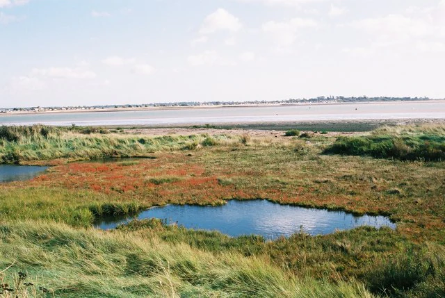
Coastal wetland landscape showing a small tidal lagoon surrounded by green and reddish saltmarsh vegetation, with a wide estuary and distant shoreline under a partly cloudy sky.
View south across the Colne Estuary towards Brightlingsea with tidal lagoons and saltmarsh in the foreground.

Colne Estuary history and protected-area timeline

Colne Estuary was formally notified as a Site of Special Scientific Interest in 1989, marking its official recognition within the British system of national nature conservation designations. The site's significance was subsequently reinforced through international and European designations, including its listing as a Ramsar wetland site of international importance in 1994, and its classification as a Special Protection Area and Special Area of Conservation under European Union nature legislation.

Over time, the accumulated designation record reflects a steadily broadening acknowledgment of the estuary's ecological and geological importance. The site's inclusion in the Nature Conservation Review and the Geological Conservation Review placed its wildlife and Earth science value within national frameworks of site selection, while National Nature Reserve status added a specific layer of active conservation management. The involvement of the Essex Wildlife Trust in managing key constituent areas, including Colne Point, Fingringhoe Wick, and Howlands Marsh, has become an important part of the site's modern conservation identity.

Scientific interest in the estuary has extended beyond its living habitats. The peat seam recorded at St Osyph Marsh, dated to roughly 4,280 years before present, has contributed to understanding of Holocene coastal evolution, while Pleistocene investigations at East Mersea have opened a window into warm-climate interglacial conditions following the Anglian glaciation, establishing the site as a reference location for Quaternary research in eastern England.

Colne Estuary landscape and geographic character

The physical landscape of Colne Estuary is defined by the tidal interaction between the River Colne and the southern North Sea. Broad intertidal mudflats flank the estuary's channels, exposed at low tide and submerged at high tide, and these are fringed by extensive saltmarshes that grade gradually inland. The result is a soft, dynamic coastline shaped by sediment deposition, tidal scour, and long-term coastal accretion.

Along the seaward edge of the estuary, shingle spits and barrier formations introduce a contrasting hard-coast element, while former gravel pits within the broader site have created localized depressions that now hold freshwater and brackish conditions. These pits add micro-topographic variety to the landscape, supporting different wetland communities from the open estuary itself.

The estuary's inland fringe incorporates reclaimed and semi-natural land, including active marshes such as St Osyph Marsh, where coastal processes continue to build and reshape the surface. The varied terrace of habitats, ranging from open water and mud through low marsh to higher marsh, dry shingle, and relict wetland basins, gives Colne Estuary its distinctive layered coastal scenery and underpins its ecological complexity.

Colne Estuary ecosystems, habitats, and plant life

Colne Estuary supports a notably rich mosaic of coastal and estuarine habitats within a single protected site. The fundamental ecological character is set by the intertidal zone, where extensive mudflats and saltmarshes form the productive base of the food web that sustains the site's waterbird populations. Tidal cycles continually rework these habitats, maintaining the open sediment conditions favored by invertebrates and the specialist plants adapted to saline, periodically flooded conditions.

Saltmarsh communities form a major habitat type, transitioning from low marsh colonised by pioneer species through to higher marsh with more diverse vegetation structure. These areas support specialised plants such as golden samphire and shrubby seablite, both of which are notable features of the site. Shingle formations along parts of the coast add a separate habitat type with its own characteristic flora.

Inland from the active estuary, former gravel pits have been incorporated into the protected area and now contribute freshwater and transitional wetland habitats, broadening the ecological range beyond purely marine and saline conditions. Combined, these elements produce a habitat complex in which marine, brackish, and freshwater influences coexist, supporting a wide variety of invertebrates, plants, and the bird populations that depend on them.

Colne Estuary wildlife and species highlights

The wildlife significance of Colne Estuary is dominated by its international importance for waterbirds. The estuarine mudflats and saltmarshes provide feeding and roosting habitat for large numbers of wintering and migratory species, with dark-bellied brent geese and black-tailed godwits reaching population levels that qualify the site under international Ramsar and Special Protection Area criteria. Six additional bird species are recognized as being of national importance at the site, including little terns, which breed in suitable sections of the coastal strip.

Beyond the bird interest, the estuary is recognized for important invertebrate assemblages associated with its saltmarshes, mudflats, and transition habitats. These invertebrates underpin the food chains that support the site's waders and wildfowl, and they also contribute to the site's broader recorded biodiversity. The combination of specialist coastal plants, varied sediments, and dynamic tidal processes supports an unusually wide range of invertebrate groups across a relatively compact geographic area.

The complex of freshwater and brackish wetland habitats in the inland parts of the site, including former gravel pits and managed marshes, adds further wildlife value, supporting different bird and invertebrate communities from those of the open estuary. The overall wildlife character is therefore one of high productivity and strong seasonal turnover, with very large numbers of birds present at certain times of year and a resident underpinning of invertebrates and plants maintained by the diversity of habitats.

Colne Estuary conservation status and protection priorities

Colne Estuary holds an unusually dense cluster of conservation designations, reflecting both its national and international ecological importance. As a Site of Special Scientific Interest, it forms part of the core network of protected wildlife sites in England, while its National Nature Reserve status indicates focused conservation management. Listing as a Ramsar wetland site of international importance acknowledges the estuary's significance under the global convention on wetlands, particularly in relation to its waterbird populations.

The Special Protection Area and Special Area of Conservation designations bring European-level recognition of the site's importance for birds and for broader habitat conservation, respectively. Inclusion in the Nature Conservation Review situates the estuary within a systematic national assessment of key wildlife sites, while its Geological Conservation Review status recognizes the scientific importance of its Pleistocene exposures. Together, these designations frame the estuary as a site of multiple, overlapping conservation interests rather than a single-feature protected area.

At a local level, the Essex Wildlife Trust's management of Colne Point, Fingringhoe Wick, and Howlands Marsh provides a practical conservation presence within the site, supporting habitat management, monitoring, and public engagement with the estuary's wildlife. The breadth of designations and active management together underline the estuary's role as a major reference site for estuarine conservation in Essex and more widely in eastern England.

Colne Estuary cultural meaning and human context

Colne Estuary sits within a long-established coastal and estuarine landscape of eastern Essex, where the River Colne and adjoining waterways have shaped local communities, economies, and traditional land use for centuries. The estuary's saltmarshes, mudflats, and grazing marshes form part of the cultural as well as the natural heritage of the region, contributing to the working coastal character that historically supported fishing, small-scale trade, and coastal land management.

Although the site is overwhelmingly valued for its natural features rather than built heritage, its position near Brightlingsea places it within a coastal community whose identity is closely tied to the estuary. The managed nature reserve areas, including Colne Point, Fingringhoe Wick, and Howlands Marsh, have also become familiar landscape features in the local area, and the presence of long-running archaeological and palaeoenvironmental records, such as the dated peat seam at St Osyph Marsh, reflects the deep historical layering of human and natural history along this stretch of coast.

Top sights and standout views in Colne Estuary

Colne Estuary's distinctive strengths lie in the combination of very large tidal habitat area, internationally important bird populations, and multiple overlapping conservation designations. The site is a benchmark location for wintering dark-bellied brent geese and black-tailed godwits in eastern England, and its saltmarshes and mudflats also support nationally important populations of species such as little terns.

The estuary's botanical and invertebrate richness adds a further layer of distinction, with specialist plants like golden samphire and shrubby seablite, and important invertebrate assemblages associated with varied saltmarsh and transition habitats. The Pleistocene exposures at East Mersea and the dated peat record at St Osyph Marsh introduce a geological and palaeoenvironmental dimension that broadens the site's significance beyond its living ecosystems, making Colne Estuary a site of scientific as well as ecological value.

Best time to visit Colne Estuary

Colne Estuary has a strongly seasonal wildlife character, with the most dramatic wildlife concentrations occurring during the winter months, when large flocks of brent geese, godwits, and other waders and wildfowl use the mudflats and saltmarshes. Late autumn through to early spring is therefore typically the most rewarding period for visitors focused on seeing the estuary's internationally important bird populations at peak numbers.

Spring and summer bring a different but complementary character, with breeding seabirds such as little terns active along suitable sections of the coast, and saltmarsh plants and invertebrates at their most visible. Conditions across the estuary can be exposed and changeable at any time of year, and tidal cycles strongly influence which areas of mudflat and saltmarsh are visible during a visit, so planning around the tides generally enhances the experience across all seasons.

Monthly climate preview

Review long-term representative point measurements and historical weather by month for Essex

Colne Estuary Climate Normals: Measured Annual Temperature and Precipitation Rhythm

Representative coordinate records show historical annual temperature ranges and monthly precipitation averages across the protected area. Examining the complete twelve-month climate profile reveals detailed long-term trends for this location.
Annual mean11 °C
5 °C17 °C
Jan
Feb
Mar
Apr
May12°
Jun15°
Jul17°
Aug17°
Sep15°
Oct12°
Nov
Dec
Warmest month
August

17.4 °C

Coolest month
February

4.7 °C

Wettest month
October

2.4 mm/day

Driest month
April

1.4 mm/day

Park location guide

Geography guide, regional context, and park location map for Colne Estuary

Colne Estuary park geography, regions, and map view in United Kingdom

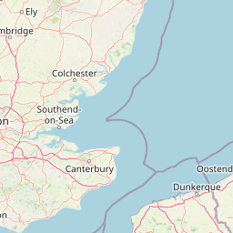
Understand where Colne Estuary sits in United Kingdom through a broader geographic reading of the surrounding landscape, nearby location context, and its mapped position within the national park landscape.

How Colne Estuary fits into United Kingdom

The United Kingdom is a parliamentary constitutional monarchy located in northwestern Europe, consisting of four constituent countries: England, Scotland, Wales, and Northern Ireland. As a major global power with over 69 million residents, it maintains significant international influence in politics, economics, and culture.

Wider geography shaping Colne Estuary in United Kingdom

The United Kingdom is an island nation located in northwestern Europe, surrounded by the Atlantic Ocean, North Sea, English Channel, Celtic Sea, and Irish Sea. It shares a land border with the Republic of Ireland to the west. The territory includes the island of Great Britain, the northeastern portion of Ireland, and most of the smaller British Isles islands.

Map view of Colne Estuary

Use this park location map to pinpoint Colne Estuary in United Kingdom, understand its exact geographic position, and read its mapped placement within the surrounding landscape more clearly.

Pigeon | © OpenStreetMap contributors

Location context for Colne Estuary

EnglandEssex
Recorded earthquake history

Review the Historical Catalogue of Recorded Earthquakes Near Colne Estuary

Examine the logged seismic history of the region surrounding Colne Estuary through this dedicated data collection. MoriAtlas provides a filtered overview of recorded earthquakes to support better understanding of the seismic context for this significant coastal protected area.

Colne Estuary Earthquake History

Catalogued events

2 events

Strongest magnitude

Magnitude 3.4

Most recent event

Nov 5, 1994

This history includes earthquakes recorded inside the park or within 50 km of its borders

Visual reference collection showcasing tidal habitats, saltmarshes, and coastal terrain.

Colne Estuary Photos, Scenery, and Protected Landscape Imagery

Visual documentation captures the dynamic coastal morphology of Colne Estuary, revealing expansive mudflats, saltmarshes, and intertidal wetland habitats. Examining these protected-area photographs provides deeper insight into the ecological character and physical geography of the Essex coast.

Coastal wetland landscape showing a small tidal lagoon surrounded by green and reddish saltmarsh vegetation, with a wide estuary and distant shoreline under a partly cloudy sky.

Park atlas

Compare adjacent coastal wetlands, regional reserves, and tidal habitats

Exploring Other Protected Areas and Parks Near Colne Estuary

Browse nearby protected landscapes and coastal reserves that share similar estuarine environments with Colne Estuary. Extending the geographic review helps map broader regional conservation networks and connected wildlife habitats across eastern England.
A soft watercolor illustration showing rolling green hills and wetlands against a light, pale sky.
Nature reserveEssex
1.8 km away#1 closest

West

Abberton Reservoir: Mapped Landscape and Protected Area Context in Essex, England

Freshwater reservoir, wetland, and historic site

Abberton Reservoir stands as a landmark of regional geography in Essex. This entry maps the site's transition from an engineered water-supply facility to a mosaic of reedbeds, marshes, and open water, providing essential habitat for migratory wildfowl and wintering bird populations.

Area
7 km²
Established
1939
Relief
Lowland
Climate
Temperate
Marine protected areaEssex
About 6.2 km away#2 closest

South

Blackwater, Crouch, Roach and Colne Estuaries Marine Conservation Zone Geography and Map

A comprehensive look at England's largest inshore marine protected area.

Covering 284 square kilometers of the Essex coast, this marine conservation zone integrates four tidal estuaries and North Sea coastal frontage into a single protected system. Recognized for its unique native oyster beds and vast intertidal mudflats, the area provides essential habitat for waterfowl. Explore the mapped terrain and overlapping conservation boundaries that define this vital estuarine landscape.

Area
284 km²
Relief
Lowland
Climate
Temperate
Scope
Marine
Nature reserveSuffolk
About 32 km away#3 closest

Northeast

Martlesham Wilds Nature Reserve: Suffolk Wetland and Protected Landscape Geography

Examining the ecological corridor along the River Deben estuary

Martlesham Wilds represents a significant lowland rewilding effort in eastern England. The 117 hectare reserve, managed by the Suffolk Wildlife Trust, creates a vital connection between ancient woodlands, tidal marshes, and freshwater wetland scrapes. Explore the geographic layout and protected boundaries of this developing sanctuary on the Deben Estuary.

Area
1.17 km²
Established
2023
Relief
Lowland
Climate
Temperate
Watercolor painting showing grassy wetlands and distant hills with a sunset sky
National parkUnited Kingdom
73 km away#4 closest

Northeast

The Broads National Park: Wetland Landscape, Rivers, and Regional Geography Atlas

Explore mapped waterways and protected reedbed ecosystems.

The Broads National Park offers a singular protected wetland landscape with over 200 kilometers of navigable waterways across its numerous shallow lakes, or 'broads.' Shaped by medieval peat excavations and natural processes, this area presents a unique geography of reedbeds and grazing marshes, punctuated by historic windmills. Discover the mapped extent of this protected landscape, its river systems, and its vital role in regional geography through structured atlas data.

Area
303 km²
Established
1989
IUCN
V
Relief
Lowland
Nature reserveSurrey
About 107 km away#5 closest

West

Wraysbury Reservoir: An Engineered Nature Reserve and Vital Wetland Habitat in Surrey

Examining infrastructure, ecology, and sonar testing geography.

Wraysbury Reservoir stands as a unique example of late-twentieth-century industrial landscape design, serving as both a primary London water resource and a protected Ramsar wetland. Its earthen embankments enclose a specialized environment where sonar research and ecological conservation coexist within the wider context of the Thames Valley. This record details the site's boundaries, its function as a wintering bird refuge, and its specialized role in UK marine testing.

Area
2.05 km²
Established
1970
Relief
Lowland
Climate
Temperate
A horizontal watercolor painting showing a soft coastal scene with rolling dunes, sparse grasses, and a calm shoreline under a light sky.
Nature reservePas-de-Calais
108 km away#6 closest

Southeast

Réserve naturelle nationale du Platier d'Oye: Protected Coastal Landscape and Wetland Geography

Coastal dunes and migratory bird habitats in Pas-de-Calais

Located along the Opal Coast, the Réserve naturelle nationale du Platier d'Oye represents a complex mosaic of tidal flats, mobile sand dunes, and humid polder meadows. This protected area offers unique insight into the ecological intersection of maritime forces and terrestrial environments, functioning as a primary staging ground for diverse migratory species within the Hauts-de-France coastal region.

Area
3.91 km²
Established
1987
IUCN
IV
Relief
Lowland
A horizontal watercolor painting showing a soft landscape with green vegetation, pink accents, and a winding body of water leading towards distant hills.
Nature reserveFrance
About 109 km away#7 closest

Southeast

Réserve naturelle régionale du mont de Couple: Protected Chalk Escarpment and Coastal Viewpoint

A limestone ridge sanctuary in the northern French Boulonnais region

Spanning a rare chalk cuesta in northern France, this protected area balances ecological conservation with distinct geological features. The reserve provides critical habitat for orchids and protected flora while serving as a strategic viewpoint across the Straits of Dover and the surrounding Opal Coast terrain.

Area
0.136 km²
Established
1997
Relief
Upland
Climate
Temperate
Nature reserveHauts-de-France
About 113 km away#8 closest

Southeast

Réserve naturelle régionale de la forteresse de Mimoyecques: Regional Nature Reserve Geography

Protected subterranean habitat and wartime heritage in Hauts-de-France.

Located in the rolling lowlands of the Pas-de-Calais, the Réserve naturelle régionale de la forteresse de Mimoyecques is a uniquely managed protected area. Its landscape integrates historical military architecture with modern biodiversity conservation, focusing on the protection of rare underground roosting environments for diverse bat species within the regional Hauts-de-France terrain.

Area
0.016 km²
Established
2012
Relief
Lowland
Climate
Temperate

Common questions about visiting, size, designation, and location context for Colne Estuary

Colne Estuary FAQs for park facts, access, geography, and protected area context

Find quick answers about Colne Estuary, including protected-area facts, park geography, trail and visitor context, and how the park fits into its surrounding country and regional landscape.
MoriAtlas Explorer

Continue Your Protected Areas Search Across the Global Atlas

Deepen your exploration by continuing the structured search for national parks and protected areas worldwide. Utilize the comprehensive filtering capabilities to compare different conservation landscapes and refine your understanding of global park geography. Discover more about the distribution and characteristics of protected natural areas.

Global natural geography