Mori Atlas logo
Biosphere reserveReserva Biológica Colonso-Chalupas

A critical biological corridor spanning the vertical transition from high Andean peaks to Amazonian foothills.

Reserva Biológica Colonso-Chalupas: Mapping Protected Landscapes in the Ecuadorian Andes

Reserva Biológica Colonso-Chalupas functions as a massive, continuous protected block within the Napo region, bridging the gap between high-altitude cordillera crests and the humid Amazon basin. This biosphere reserve encompasses a dramatic vertical gradient that includes cold mountain highlands, dense cloud forests, and lowland tropical terrain. By safeguarding the headwaters of the upper Napo River system, the reserve serves as an essential ecological link between major conservation units in the eastern Andes.

biological reserveAndean-Amazon corridoreastern Andescloud foresttropical foresthigh-altitude páramo

Reserva Biológica Colonso-Chalupas

Biosphere reserve

Park overview

Structured park overview, official facts, and landscape profile for Reserva Biológica Colonso-Chalupas

Reserva Biológica Colonso-Chalupas park facts, protected area profile, and essential visitor context

Review the core facts for Reserva Biológica Colonso-Chalupas, including designation, size, terrain, visitor scale, habitats, and operating context in one park-focused overview.

About Reserva Biológica Colonso-Chalupas

Reserva Biológica Colonso-Chalupas is one of Ecuador's newer biological reserves, created specifically to protect a critical transition zone where the Andes descend into the Amazon basin. The reserve occupies the outer, eastern slopes of the Cordillera Oriental in Napo Province, within the cantons of Archidona and Tena, and links directly to two of Ecuador's most important existing protected areas: the Reserva Ecológica Antisana to the north and Parque Nacional Llanganates to the south. Together, these three areas form a continuous arc of conservation land that wraps around the upper watershed of the Napo River.

The reserve's defining characteristic is its extraordinary altitudinal range, which climbs from roughly 560 meters above sea level in lower, Amazon-influenced zones to over 4,400 meters on the high ridges of the eastern Andean cordillera. This nearly 4,000-meter vertical drop encompasses an entire spectrum of Andean to Amazonian environments, with corresponding shifts in temperature, precipitation, and ecological character. Annual rainfall varies sharply across this gradient, from moderate levels on the cooler upper elevations to very high totals in the warmer lowland forests, while average annual temperatures shift from near-freezing conditions in the highest zones to warm tropical values in the lowest areas.

Within this gradient, the reserve protects six major ecosystem types, each with native forest and vegetation in a high degree of conservation. These ecosystems collectively support substantial biological and genetic potential, sustain ecological functions such as watershed regulation and habitat connectivity, and provide a buffer against the degradation of surrounding landscapes. The reserve's design reflects a recognition that the long-term integrity of the upper Napo basin depends on protecting complete elevational sequences rather than isolated fragments.

Quick facts and research context for Reserva Biológica Colonso-Chalupas

Reserva Biológica Colonso-Chalupas is located in Napo Province, Ecuador, covering parts of the cantons of Archidona and Tena. It is a category of biological reserve within Ecuador's national protected areas system, oriented toward conservation of natural processes and genetic resources.

The reserve spans roughly 93,000 hectares on the eastern slope of the Ecuadorian Andes, with elevations ranging from around 560 meters in the lower Amazon-influenced zones to over 4,400 meters on the higher Andean crests. Its position between Antisana Ecological Reserve and Llanganates National Park gives it strong connectivity value within the upper Napo watershed.

Protection and recognition

Documented conservation scope and official designation details

Reserva Biológica Colonso-Chalupas Protection Status and Terrestrial Boundaries

Reserva Biológica Colonso-Chalupas maintains a documented terrestrial protection scope within the regional conservation network. Structured facts compile the official designation history and administrative parameters for this protected area.

Protection details

Protection scope
Terrestrial
Transboundary protection
No
Park context

Deeper park guide and search-rich context for Reserva Biológica Colonso-Chalupas

Reserva Biológica Colonso-Chalupas history, landscape, wildlife, and travel context

Explore Reserva Biológica Colonso-Chalupas through its history, landscape character, ecosystems, wildlife, conservation priorities, cultural context, and seasonal travel timing in a structured park guide built for atlas discovery and search intent.

Why Reserva Biológica Colonso-Chalupas stands out

Colonso-Chalupas is especially known for its remarkable elevational range, which compresses Andean highlands, cloud forests, and Amazonian lowlands into a single protected area. The reserve functions as a biological corridor linking Antisana Ecological Reserve with Llanganates National Park, reinforcing the conservation value of the entire upper Napo basin. Its dramatic bioclimatic gradient produces a sequence of contrasting ecosystems within relatively close geographic proximity, from cold páramo-like environments at the highest elevations to hot and humid tropical forests descending toward the Amazon plain.
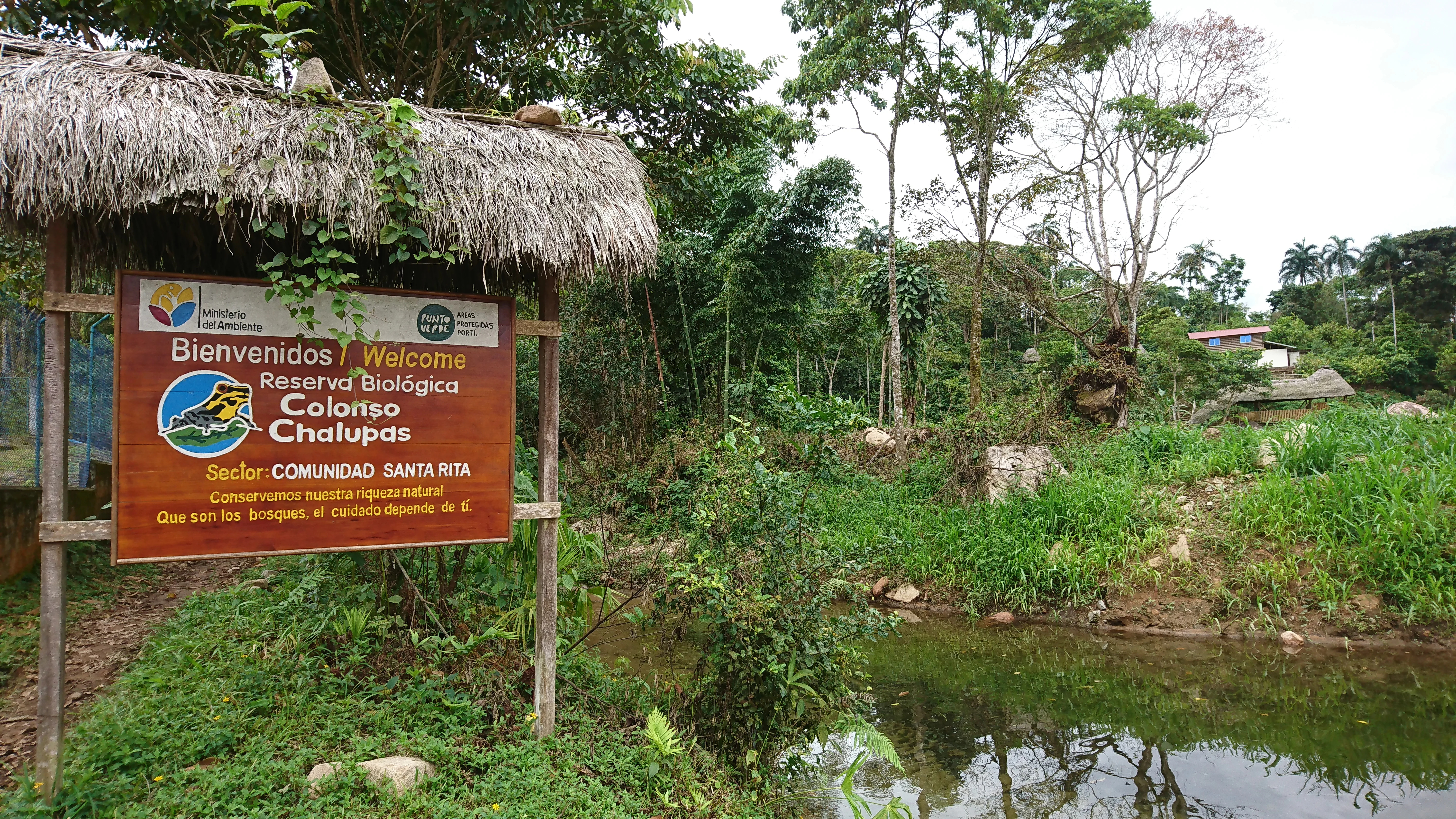
A wooden sign under a thatched roof structure welcomes visitors to the Reserva Biológica Colonso-Chalupas in the Santa Rita community, situated near trees and a small pond.
Welcome sign at the Santa Rita community entrance to the Reserva Biológica Colonso-Chalupas in Ecuador.

Reserva Biológica Colonso-Chalupas history and protected-area timeline

Reserva Biológica Colonso-Chalupas was formally established as a biological reserve on February 26, 2014, through Interministerial Agreement No. 011. The reserve was incorporated into Ecuador's Sistema Nacional de Áreas Protegidas, the national framework responsible for managing the country's protected natural areas.

Its creation reflected a deliberate conservation strategy focused on two priorities: safeguarding ongoing natural ecological processes, and preserving genetic resources within a region of exceptional biological diversity. The reserve was also conceived as a connective piece of a broader conservation landscape, joining Antisana Ecological Reserve and Llanganates National Park to maintain ecological continuity across the upper Napo watershed. By formalizing protection of the eastern Andean slopes and their transition into Amazonian forests, the establishment of Colonso-Chalupas completed a significant corridor in one of Ecuador's most ecologically important regions.

Reserva Biológica Colonso-Chalupas landscape and geographic character

The landscape of Reserva Biológica Colonso-Chalupas is defined by an extreme vertical gradient along the eastern face of the Ecuadorian Andes. High ridges and cold crests of the Cordillera Oriental mark the upper end of the reserve, while the lower elevations descend into foothills that grade into the Amazon basin. Rivers draining these slopes feed into the upper Napo River system, and their valleys shape much of the terrain's internal geography.

At the highest elevations, the terrain takes on the character of cold Andean highlands, with exposed slopes, high-altitude grasslands, and rocky crests subject to low temperatures. Moving downward, the landscape transitions through mid-elevation mountain slopes, increasingly vegetated with cloud forest and humid montane forest. In the lower portion of the reserve, the land softens into warmer foothills, with deeper valleys, denser vegetation cover, and the beginning of the characteristic humid tropical forest environment associated with the western edge of the Amazon basin.

Reserva Biológica Colonso-Chalupas ecosystems, habitats, and plant life

The reserve's nature is shaped by its position across virtually the full ecological spectrum between the eastern Andes and the Amazon basin. The combination of high precipitation, steep slopes, and an immense altitudinal range has produced a sequence of six distinct ecosystem types within the reserve's boundaries.

At the upper limit, ecosystems reflect cold and relatively drier conditions, with sparse vegetation adapted to low temperatures and strong elevation. As elevation decreases, vegetation becomes denser and more stratified, transitioning through montane and cloud forests characterized by persistent humidity and frequent mist. Lower in the reserve, ecosystems shift into the humid, species-rich tropical forests at the western edge of Amazonia, where high annual rainfall and warm temperatures support dense, multi-layered forest cover.

Because these ecosystems remain largely intact, the reserve preserves a continuous vertical transect of native vegetation, allowing ecological processes such as species migration along elevation gradients, watershed regulation, and nutrient cycling to function across the landscape rather than in isolated fragments.

Reserva Biológica Colonso-Chalupas wildlife and species highlights

The altitudinal and climatic diversity of the reserve supports wildlife patterns typical of both Andean and Amazonian environments, although the available source material does not detail specific species inventories. The reserve's combination of high-altitude, cold environments and lowland, humid tropical forest provides habitat for species associated with páramo and montane forest habitats as well as those typical of western Amazonian forests.

Because the reserve connects Antisana Ecological Reserve to Llanganates National Park, it also functions as a movement corridor for wildlife that depends on extensive, connected habitat across elevation gradients. This connectivity value, rather than any single species, is one of the reserve's most important wildlife-related contributions to the broader regional conservation landscape.

Reserva Biológica Colonso-Chalupas conservation status and protection priorities

Reserva Biológica Colonso-Chalupas is a conservation-focused protected area, with its biological reserve designation specifically aimed at safeguarding natural processes and genetic resources. Its inclusion in Ecuador's national system of protected areas institutionalizes that role and places it within the country's broader strategy for preserving representative samples of its ecosystems.

The reserve's most significant conservation contribution is its function as a corridor between Antisana Ecological Reserve and Llanganates National Park. By occupying the geographic space between these two larger protected areas, Colonso-Chalupas helps maintain ecological connectivity across a vast elevational and climatic gradient in the upper Napo basin. This connectivity is essential for species that move seasonally or ontogenetically across elevation zones, and for the long-term resilience of forested watersheds that supply the lower basin.

The protection of six intact major ecosystems within a single reserve also reduces fragmentation, supports watershed stability, and preserves genetic resources that depend on continuous, healthy populations across environmental gradients. Together, these qualities give Colonso-Chalupas substantial regional conservation importance well beyond the boundaries of the reserve itself.

Top sights and standout views in Reserva Biológica Colonso-Chalupas

Reserva Biológica Colonso-Chalupas stands out for one quality above all: it is one of the few protected areas in Ecuador that captures, in a single continuous unit, almost the entire ecological transition from high Andes to Amazon basin. Few reserves combine an elevational range of nearly 4,000 meters with the intact forest cover and institutional protection status needed to make that gradient meaningful for conservation.

The reserve also serves as a critical connective link among three of Ecuador's major Andean-Amazonian reserves, making it a key structural element of the country's upper Napo conservation landscape rather than an isolated natural area.

Best time to visit Reserva Biológica Colonso-Chalupas

The reserve spans climates ranging from cold Andean highlands to warm Amazonian lowlands, so optimal conditions vary by elevation. Generally, the lower Amazon-influenced areas are warm and wet year-round, while higher elevations are cooler and can experience more variable conditions. Because the reserve covers such a wide climatic gradient, the best timing depends largely on which part of the reserve and which ecosystems a visitor intends to experience.
Monthly climate preview

Long-term representative monthly temperature and precipitation data for Napo

Reserva Biológica Colonso-Chalupas Climate Normals and Annual Temperature Rhythm

Representative coordinate measurements track the recorded annual temperature range and precipitation totals for Reserva Biológica Colonso-Chalupas across twelve distinct months. Examining the complete monthly climate profile reveals specific long-term averages for daily minimum and maximum values.
Annual mean13 °C
11 °C14 °C
Jan13°
Feb13°
Mar13°
Apr13°
May13°
Jun12°
Jul11°
Aug11°
Sep12°
Oct13°
Nov14°
Dec13°
Warmest month
November

13.7 °C

Coolest month
July

11.1 °C

Wettest month
April

6.7 mm/day

Driest month
August

3.1 mm/day

Park location guide

Geography guide, regional context, and park location map for Reserva Biológica Colonso-Chalupas

Reserva Biológica Colonso-Chalupas park geography, regions, and map view in Ecuador

Understand where Reserva Biológica Colonso-Chalupas sits in Ecuador through a broader geographic reading of the surrounding landscape, nearby location context, and its mapped position within the national park landscape.

How Reserva Biológica Colonso-Chalupas fits into Ecuador

Ecuador is a presidential republic located in northwestern South America, with Quito as its capital and Guayaquil as its largest city. The country spans 283,561 km² and encompasses the Galápagos Islands, a volcanic archipelago famous for unique wildlife that helped shape Darwin's theory of evolution. Ecuador is a plurinational state with Spanish as the official language, though Kichwa and Shuar are recognized for indigenous peoples.

Wider geography shaping Reserva Biológica Colonso-Chalupas in Ecuador

Ecuador is located in northwestern South America along the Pacific coast. It shares borders with Colombia to the north and Peru to the east and south. The country includes the Galápagos Islands, a volcanic archipelago in the Pacific Ocean approximately 1,000 km west of the mainland. The territory encompasses diverse terrain including the Amazon rainforest in the east, the Andean highlands in the center, and coastal plains along the Pacific.

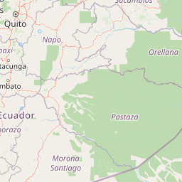
Map view of Reserva Biológica Colonso-Chalupas

Use this park location map to pinpoint Reserva Biológica Colonso-Chalupas in Ecuador, understand its exact geographic position, and read its mapped placement within the surrounding landscape more clearly.

Pigeon | © OpenStreetMap contributors

Location context for Reserva Biológica Colonso-Chalupas

Napo

Explore protected area photography capturing extreme elevational gradients, cloud forests, and high-altitude habitats.

Reserva Biológica Colonso-Chalupas Photos and Scenery: Visualizing the Andean-Amazonian Landscape

Visual documentation provides direct insight into the rugged terrain and dramatic ecological transitions defining Reserva Biológica Colonso-Chalupas. Examining field photography reveals the complex physical structure of upper Napo watershed habitats, from cold Andean ridges down to humid tropical forest environments.

A wooden sign under a thatched roof structure welcomes visitors to the Reserva Biológica Colonso-Chalupas in the Santa Rita community, situated near trees and a small pond.

Park atlas

Compare adjacent Andean Amazon reserves and connected conservation corridors

Parks Near Reserva Biologica Colonso Chalupas and Surrounding Protected Landscapes

Browsing other parks near Reserva Biologica Colonso Chalupas reveals connected conservation lands along the eastern Andean slope. Comparing these adjacent protected areas provides deeper insight into the upper Napo River basin and regional mountain ecosystems.
Watercolor illustration of a winding path through a green landscape with snow capped mountains in the distance against a pink sky.
National parkNapo
About 4.7 km away#1 closest

Northeast

Parque nacional Antisana: Volcanic Terrain and Andean Protected Area Geography

High-altitude ecosystems spanning Napo and the Andean corridor

Spanning the rugged Cordillera Real, Parque nacional Antisana protects a vast sweep of volcanic terrain dominated by its central stratovolcano. From glacial fields to the water-retention capacity of its páramo wetlands, the area represents a crucial node in Ecuador's conservation network, providing a sanctuary for Andean condors and diverse montane species.

Area
1,205.81 km²
Established
1993
IUCN
Ia
Relief
Mountain
National parkEcuador
About 14 km away#2 closest

South

Llanganates National Park: Detailed Atlas Entry for Ecuador's Protected Landscape

Explore the mapped geography and regional context of this Ecuadorian national park.

Llanganates National Park is a designated national park offering rich opportunities for geographic and landscape exploration. As a significant protected area in Ecuador, it provides crucial context for understanding the country's natural terrain and the distribution of its conservation landscapes. This entry is designed to facilitate an atlas-style discovery of the park's location, boundaries, and its role within the broader geography of the region.

Area
2,197.07 km²
Established
1996
IUCN
II
Relief
Mountain
National parkCotopaxi Province
About 26 km away#3 closest

West

Cotopaxi National Park: Ecuador's Mapped Protected Landscape and Regional Geography

Explore the geographic context of this national park.

Cotopaxi National Park represents a key protected landscape within Ecuador, located in Cotopaxi Province. This page facilitates detailed exploration of the park's mapped boundaries and its contribution to the regional geography. Understand the specific characteristics of this national park as part of a broader atlas of protected areas and natural terrains.

Area
333.93 km²
Established
1975
IUCN
II
Relief
Mountain
National parkEcuador
About 40 km away#4 closest

Northeast

Sumaco Napo-Galeras National Park: Ecuador's Volcanic National Park Landscape

Explore protected areas and biodiversity in the Andean-Amazon transition.

Sumaco Napo-Galeras National Park protects a dramatic volcanic landscape in Ecuador, showcasing a significant elevation gradient that supports diverse cloud forest and Amazonian rainforest habitats. This national park is recognized for its endemic species and rich avifauna, offering a compelling case study for understanding protected land geography and ecological transitions within South America.

Area
2,067.49 km²
Established
1994
IUCN
II
Relief
Mountain
A pale, minimalist watercolor painting showing a wide, grassy field leading to distant, low mountain hills under a bright, light sky.
Wildlife reservePichincha
About 54 km away#5 closest

Northwest

Refugio de Vida Silvestre Pasochoa: Volcanic Crater and Andean Forest Protected Area

Geographic atlas of the Pichincha volcanic highlands

Located in the Pichincha province, Refugio de Vida Silvestre Pasochoa protects an essential highland habitat defined by its steep volcanic crater walls and dense bamboo stands. This area provides a scientific reference for inter-Andean vegetation, featuring a sharp contrast between forested inner slopes and surrounding agricultural landscapes. Map the ecological gradient of this protected refuge and explore its role within the broader northern Andean geographic context.

Area
9.799 km²
Established
1996
IUCN
Ib
Relief
Mountain
A wide watercolor illustration showing a misty landscape with green trees in the midground and faint mountain peaks in the background.
Nature reserveEcuador
About 58 km away#6 closest

West

Reserva Ecológica Los Illinizas: Geographic Atlas and Andean Protected Nature Reserve

Volcanic terrain and cloud forest ecosystems in central Ecuador

Spanning across the provinces of Cotopaxi, Pichincha, and Santo Domingo de los Tsáchilas, Reserva Ecológica Los Illinizas preserves a significant vertical gradient of Andean ecosystems. The reserve protects the western flanks of the Illiniza volcanoes, Quilotoa, and El Corazón, offering a detailed look at high-altitude biodiversity and the transition from rugged mountain peaks to lush western cloud forests.

Area
1,342.33 km²
Established
1996
IUCN
Ia
Relief
Mountain
Watercolor illustration showing a mountain landscape with a snow-capped peak, a lake, and green hills.
National parkEcuador
About 78 km away#7 closest

South

Sangay National Park: Ecuador's National Park for Mapped Landscape and Geographic Discovery

Explore Ecuador's protected area boundaries and regional terrain.

Sangay National Park serves as a crucial protected landscape within Ecuador, offering rich opportunities for atlas and geography exploration. This page details the park's specific mapped boundaries and its natural terrain, providing essential context for understanding its place within South America's broader geographic tapestry. Investigate Sangay National Park's identity as a protected national park and its value for focused landscape and regional discovery.

Area
5,177.65 km²
Established
1979
IUCN
II
A soft watercolor painting of a hilly, grassy landscape with distant mountains in muted greens and pinks.
Wildlife reserveChimborazo
About 89 km away#8 closest

Southwest

Reserva de Producción de Fauna Chimborazo: Volcanic Landscapes and Andean Wildlife Reserve

High-altitude watershed and páramo geography in central Ecuador.

Spanning from glacial summits to arid puna plains, the Reserva de Producción de Fauna Chimborazo represents a complex Andean ecosystem. This wildlife reserve protects vital watersheds, glacial meltwater sources, and native camelid habitats within the shadows of Ecuador's tallest peaks, offering a detailed look at high-altitude conservation and volcanic terrain.

Area
526.83 km²
Established
1987
IUCN
IV
Relief
Mountain

Common questions about visiting, size, designation, and location context for Reserva Biológica Colonso-Chalupas

Reserva Biológica Colonso-Chalupas FAQs for park facts, access, geography, and protected area context

Find quick answers about Reserva Biológica Colonso-Chalupas, including protected-area facts, park geography, trail and visitor context, and how the park fits into its surrounding country and regional landscape.
MoriAtlas Explorer

Continue Your Protected Areas Search Across the Global Atlas

Deepen your exploration by continuing the structured search for national parks and protected areas worldwide. Utilize the comprehensive filtering capabilities to compare different conservation landscapes and refine your understanding of global park geography. Discover more about the distribution and characteristics of protected natural areas.

Global natural geography